Browse Listings in Europe > Germany > German Provinces
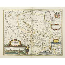
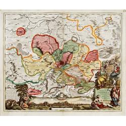
Osnabrugensis episcopatus.
A beautiful map of Munster centered on the city of Osnabruck. Prepared by Joannes Michael Gigas (1580-1650+), a doctor, mathematician and geographer. Showing an inset wit...
Place & Date: Amsterdam, 1638
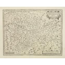
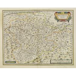
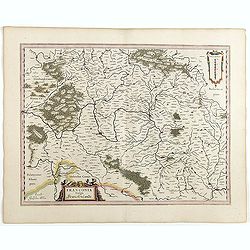
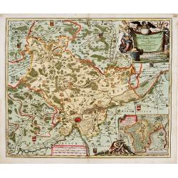
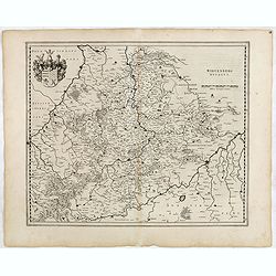
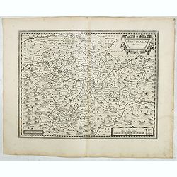
Westphalia Ducatus.
Extremely rare first edition of this beautiful map of Westphalia.Jodocus Hondius Jr. planned to produce a new modern atlas less dependent on the Mercator plates that his ...
Place & Date: Amsterdam, 1629
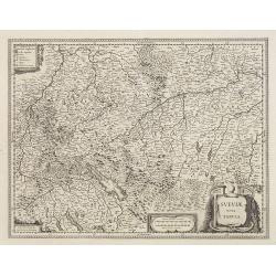
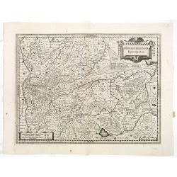
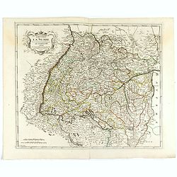
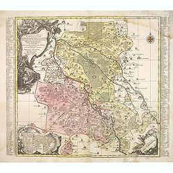
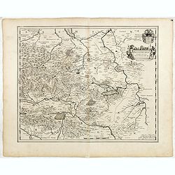
Sueviae Nova Tabula.
Extremely rare first edition of this beautiful map of Swaben, including Ulm, Augsburg, Stuttgart, Zurich, Lucerne and Lake Constance.Jodocus Hondius Jr. planned to produc...
Place & Date: Amsterdam, 1629
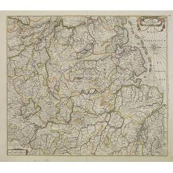
Nova Totius Westphaliae descriptio.
Map of the northern provinces of Germany, including the Wad islands. West to the top. Including Bremen, Hildesheim, Kassel, Düsseldorf, etc. Also including the Dutch pro...
Place & Date: Amsterdam, 1680
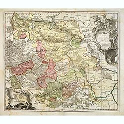
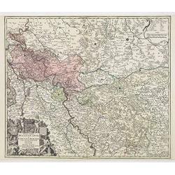
Principatus Halberstadiensis, abbat : Quedlinburgens cum Comitatu Wernigerodano, ad hodiernum verum statum ex acta prodiit ex officina geogr. . .
Detailed map showing principality Halberstadt, Abtei Quedlinburg and the county Wernigerode. Including the towns of Osterwieck, Stollberg, Aschersleben and Oschersleben.
Place & Date: Augsburg, 1750
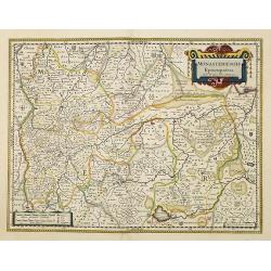
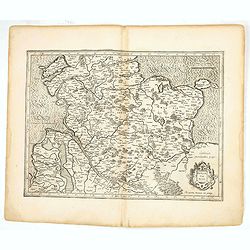
Monasteriensis Episcopatus.
The extremely rare first edition of this beautiful map of Munster.Jodocus Hondius Jr. planned to produce a new modern atlas less dependent on the Mercator plates that his...
Place & Date: Amsterdam, 1629
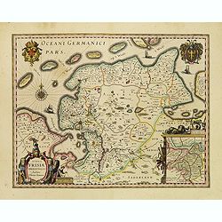
Typus Frisiae Orientalis.
Finely engraved map of east Frisia in Germany with the Watten islands. With inset map of the area south of Emden. Prepared by Ubbo Emmius (1547-1625). A very decorative t...
Place & Date: Amsterdam, 1635
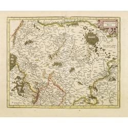
Palatinatus Rheni.
Map depicting part of Germany provinces.
Place & Date: Amsterdam, 1630
Nova et Accurata Ducatus Cliviae et Comitatus Marchiae.
With an elaborate -uncolored- title cartouche.
Place & Date: Augsburg, 1728
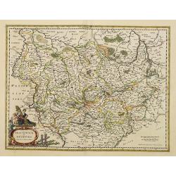
Westphalia Ducatus.
Elegantly engraved map of Westphalia including Hamm and Lippstadt. The mountainous topography is graphically depicted and several small coats of arms dot the map. Strapwo...
Place & Date: Amsterdam, 1638
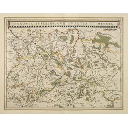
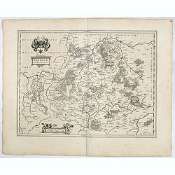
Saxonia Superior, cum Lusatia et Misnia.
Finely engraved and detailed map of Saxony including Halle, Leipzig, Meissen, and Dresden. Filled with forests and tiny villages. It presents Prague close to the centre o...
Place & Date: Amsterdam, 1638
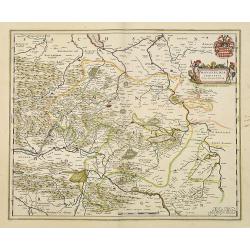
Mansfeldia Comitatus. . .
Centered on Mansfield and prepared by Telemann Stella (1527-1589) a German cartographer who made maps of Germany and the Holy Land.As Willem Blaeu died in 1638 most of hi...
Place & Date: Amsterdam, 1638
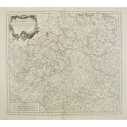
Cours du Danube, Feuille 1 contenant LA SUABE . . .
Fine map of part of the River Danube, including the southern German province of Swaben.From his rare atlas "Theatre de la Guerre en Allemagne, contenant toutes les O...
Place & Date: Paris, 1744
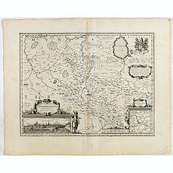
Franconia vulgo Franckenlandt.
Fine copy centered on Bamberg, Nuremberg, Würzburg, and Nuremberg. French text on verso. Würzburg is the main city in Franconian wine country. Grapevines cover the stee...
Place & Date: Amsterdam, 1635
Bravnswyck et Meydburg. . .
As Willem Blaeu died in 1638 most of his maps are actually published by his son Joan. This maps carries his (engraved) signature and was actually published in volume II o...
Place & Date: Amsterdam, 1638
Westphalia Ducatus.
Originally engraved for Jodocus Hondius II, at his death in August 1629 this map was, among 39 other copper plates, purchased by Willem Blaeu who deleted Hondius' name an...
Place & Date: Amsterdam, 1645
Monasteriensis Episcopatus.
A very detailed map of Germany centered on Munster and Linge. Also showing Wessel to the top of the map and Oldenburg to the right. North to the right. The map is adorned...
Place & Date: Amsterdam, 1638
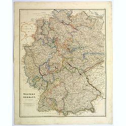
Western Germany.
A lovely, large steel engraved map of Western Germany. Some of the states engraved are: Holstein, Hannover, Mecklenburg, Saxony, Bavaria, Württemberg and Nassau. An extr...
Place & Date: London, 1839
Geographica descriptio Montani cujusdam districtus in ..
Detailed map including the towns of Thurnau, Bayreuth, Culmbach, etc. With fine panoramic view of Thurnau. Upper left and right splendid title cartouches.The map is paint...
Place & Date: Nurenberg, 1710
Waldeck Comitatus.
FIRST EDITION, FIRST ISSUE OF THIS MAP. From the 1634 edition of Blaeu's Atlas Novus, the first edition of this work.Important early map of Waldeck. Attractive coat of ar...
- $100 / ≈ €94
Place & Date: Amsterdam, 1634
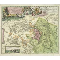
Nova Territorii Erfordien in suas praefecturas..
"Showing the area of Erfurt. In the lower part, there is a panoramic view of the town. Lower left and right splendid cartouches.The cartouches are painted in a stron...
- $300 / ≈ €281
Place & Date: Nurenberg, 1740
Nova et accurata Territorii Ulmensis cum dominio Wainensi..
"Showing the area of Ulm. In lower part inset map of property ""zu Wein"". Upper right splendid title cartouche.The map is painted in strong and ...
- $500 / ≈ €468
Place & Date: Nurenberg 1720
Electoratus saxonici praefecturae annaburgensis pretzschens torgaviensis schweinicensis. . .
Highly detailed map showing the regions of Annaburg, Pretzsch, Schweinitz in Sachsen-Anhalt, Torgau in Sachen and Mühlberg an der Elbe in Brandenburg. In the center of t...
- $60 / ≈ €56
Place & Date: Augsburg, 1750
Cercle de Haute Saxe.
Finely and crisply engraved map of Germany, centered on Leipzig .Venetian edition of Giles Didier Robert De Vaugondy's map from Atlas Universel printed in 1776-84.Ornamen...
- $150 / ≈ €140
Place & Date: Venice, 1776 - 1784
Wirtenberg Ducatus.
FIRST EDITION, FIRST ISSUE OF THIS MAP. From the 1634 edition of Blaeu's Atlas Novus, the first edition of this work. PROOF STATE with blank upper right corner, only incl...
- $100 / ≈ €94
Place & Date: Amsterdam, 1634
![Partie septentrionale du cercle de Haute Saxe [...] Brandebourg.](/uploads/cache/33211-250x250.jpg)
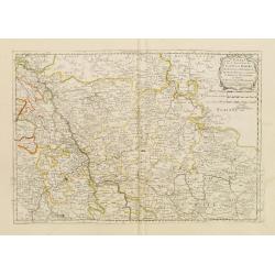
Partie septentrionale du cercle de Haute Saxe [...] Brandebourg.
Finely and crisply engraved map of north eastern part of Germany, including part of Poland. With inset map of Brandenburg. Map by Giles Didier Robert De Vaugondy with era...
- $150 / ≈ €140
Place & Date: Paris, c. 1760
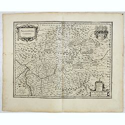
Nassovia comitatus.
Elegantly engraved map of the region including Koblenz, Sigen and Dillenburg. The mountainous topography is graphically depicted and there is a coats of arms in the corne...
- $100 / ≈ €94
Place & Date: Amsterdam, 1634
Mansfeldia Comitatus. . .
FIRST EDITION, FIRST ISSUE OF THIS MAP. From the 1634 edition of Blaeu's Atlas Novus, the first edition of this work.Centered on Mansfeld and its surrounding region, this...
- $100 / ≈ €94
Place & Date: Amsterdam,1634
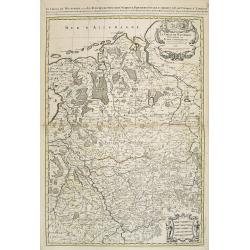
Haute Partie de la Basse Saxe..
Fine map of the northeastern part of Germany, including Hamburg and the rivers Wesel and Elbe. This edition carries the date 1679. Nicolas Sanson was to bring about th...
- $75 / ≈ €70
Place & Date: Paris, 1679
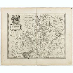
Hassia Landgraviatus.
FIRST EDITION, FIRST ISSUE OF THIS MAP. From the 1634 edition of Blaeu's Atlas Novus, the first edition of this work.Important map of Hesse in Germany, centered on the to...
- $100 / ≈ €94
Place & Date: Amsterdam, 1634
Estats de la Succession de Cleves/ Iuliers..
Fine map of western Germany.This edition carries the date 1650 and the publishers address A PARIS chez l'Autheur aux Galleries du Louvre. Nicolas Sanson was to bring abou...
- $60 / ≈ €56
Place & Date: Paris 1650
Holsatia ducatus.
Map of Holsatia. Including the town of Hamburg.Mercator was born in Rupelmonde in Flanders and studied in Louvain under Gemma Frisius, Dutch writer, astronomer and mathem...
- $150 / ≈ €140
Place & Date: Amsterdam, 1606
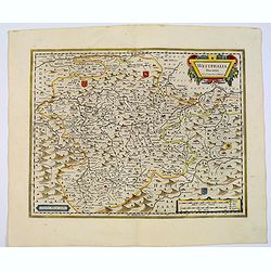
Westphalia Ducatus.
Originally engraved for Jodocus Hondius II, at his death in August 1629 this map was, among 39 other copper plates,purchased by Willem Blaeu who deleted Hondius' name and...
- $100 / ≈ €94
Place & Date: Amsterdam, 1634
Osnabrugensis Episcopatus.
Originally engraved for Jodocus Hondius II, at his death in August 1629 this map was, among 39 other copper plates, purchased by Willem Blaeu who deleted Hondius' name an...
- $150 / ≈ €140
Place & Date: Amsterdam, 1634
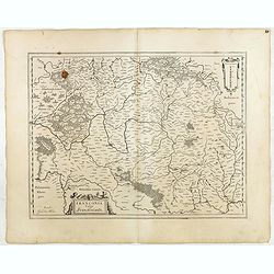
Franconia vulgo Franckenlandt.
FIRST EDITION, FIRST ISSUE OF THIS MAP. From the 1634 edition of Blaeu's Atlas Novus, the first edition of this work.Map highlights all the major cities of this region li...
- $100 / ≈ €94
Place & Date: Amsterdam, 1634
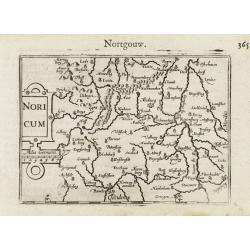
Noricum.
A miniature map showing a part of Bavaria, including the cities of Bamberg and Nuremberg. Title cartouche on the left side.First published in 1598 in his Caert-Thresoor, ...
- $50 / ≈ €47
Place & Date: Amsterdam / Frankfurt, 1609
Le Cercle de Westphalie . . .
Fine map of the Westphalia Duchy with a decorative cartouche and small scale of miles.Alexis-Hubert Jaillot (1632-1712), was a French cartographer. He joined the Sanson...
- $150 / ≈ €140
Place & Date: Amsterdam, 1692
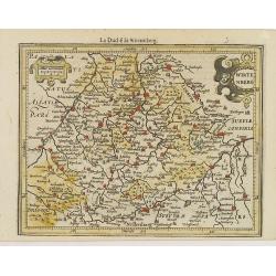
Wirtenberg.
Detailed map centered on Baden-Württemberg. With major cities of the area named.From the first French-text edition of Jodocus Hondius' Atlas Minor. Shortly after the p...
- $40 / ≈ €37
Place & Date: Amsterdam, 1608
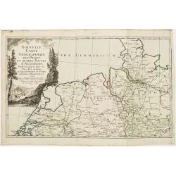
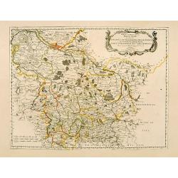
Nouvelle carte géographique des postes et autres routes d'Allemagne. . .
Map showing the northern provinces in Germany and part of the Netherlands. Decorative title cartouche in the upper left corner. A so-called post road maps.
- $80 / ≈ €75
Place & Date: Paris, 1766
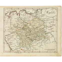
Westphalen.
Nice small map of Westphalia in Germany by Johannes Walch in his rare Allgemeiner Atlas Nach den bewährsten Hülfsmitteln und astronomischen Ortsbestimungen…, edition ...
- $50 / ≈ €47
Place & Date: Augsburg, 1812