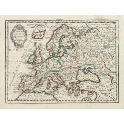
L' Europe Dressée sur les Observations de Mrs. de l' Academie Royale des Sciences..
Charming small map of Europe, including Iceland and the Mediterranean. Based on the geography of Guillaume Delisle.From Le Nouveau et Curieux Atlas Geographique et Histor...
Place & Date: Paris, 1719
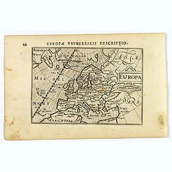
Europa.
A lovely miniature map of the continent of Europe, published by Petrus Bertius, in Amsterdam at the beginning of the seventeenth century.Engraved by J. Hondius, it has a ...
Place & Date: Amsterdam, 1606

Gallia.
Extremely rare map of France, Netherlands, Southern England, Switzerland, and Northern Spain. This map was never regularly included in the Theatrum; Denuce mentions the i...
Place & Date: Antwerp, ca 1598
Lumen Historiarum Per Occidentem ex Conatibus Fran. Haraei Antverpia.'
Showing Europe.Cartographical sources: Frans van Haren [more commonly called Haraeus] who was born circa 1555 and died in 1631. He flourished between about 1615 and 1624,...
Place & Date: Antwerp, 1624
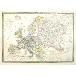
Nouvelle carte physique et politique de l'Europe. Les limites d'états.
Very large, uncommon updated version of the map of Europe prepared by H. Brué and updated by A. Vuillemin. In lower margin "Nouvelle edition" and a date (1875)...
Place & Date: Paris, 1875

Carte d'Europe divisée en ses Empires et Royaumes.
Uncommon and decorative wall map of Europe, prepared by Clouet. Superb decoration including a wonderful rococo border with vignettes describing historical scenes. Below t...
Place & Date: Paris, Mondhare, 1788
![Grande prefecture des Gavels. [de l'Europe / Figure LX] 135](/uploads/cache/38436-250x250.jpg)
Grande prefecture des Gavels. [de l'Europe / Figure LX] 135
A fine and uncommon early 17th-century map of Europe.From the French text edition of "Description d'Univers," 1683. by Allain Manneson Mallet (1630-1706), a wel...
- $30 / ≈ €28
Place & Date: Paris, 1683
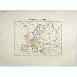
Carta generale di Europa (Tav IV)
This large-format Europe map is finely engraved and beautifully colored and was prepared by Girolamo Petri, a lawyer who served as a senior official within the Vatican’...
- $750 / ≈ €702
Place & Date: Rome, 1858
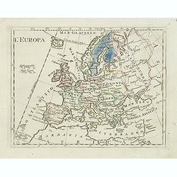
L'Europa.
Charming map of Europe from the rare atlas Atlante Tascabile o sia Serie di Num. XXI Cartine Geografiche nelle quali si rappresenta in ristretto lo Stato Attuale di tutte...
- $60 / ≈ €56
Place & Date: Rome, 1823
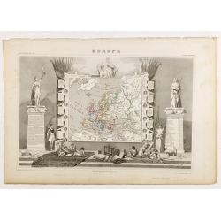
Europe.
While the map itself is quite simple without a great deal of detail, the surrounding engravings make this one of the most decorative 19th century maps. The map is frame...
- $150 / ≈ €140
Place & Date: Paris 1850