Search Listings matching "blaeu" in Europe > Belgium > Belgium Provinces
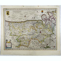
Flandria et Zeelandia Comitatus.
Includes Flanders and Zeeland. The map originally engraved in 1641 for Sanderus 'Flandria Illustrata', was used several times in Blaeu's atlases.More about maps by Willem...
- $250 / ≈ €215
Date: Amsterdam, 1645
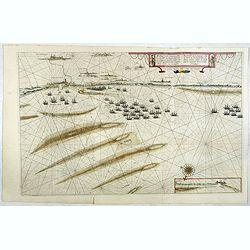
Afbeeldinge vande vermaerde seehaven .. Duynkerken..
Blaeu's map of the coast of the French coast from Duinkerk till Waldamme. In an inset, lower right the continuation till Calais. Many ships offshore Duinkerk, with soundi...
- $500 / ≈ €429
Date: Amsterdam, 1645