Search Listings matching "levasseur" in Europe
![Dépt. De L'Aude. N°10. [ Carcassonne ]](/uploads/cache/27089-250x250.jpg)
Dépt. De L'Aude. N°10. [ Carcassonne ]
Map of the Aude region, centered on the town of Carcassonne. Reaching to the right till the Mediterranean.Lovely map from one of the last decorative atlases of the ninete...
Date: Paris, A. Combette, 1852
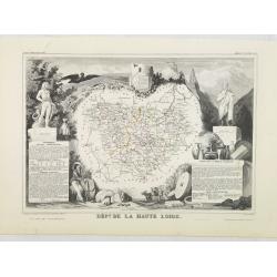
Dépt. De La Haute Loire. N°42.
Map of the Upper Loire region in France.Lovely map from one of the last decorative atlases of the nineteenth century.The rather simple map is framed by medallion portrait...
- $50 / ≈ €43
Date: Paris, A. Combette, 1852
![Dépt. du Morbihan. N°. 55. [ Morbihan, Belle-Ile ]](/uploads/cache/43041-250x250.jpg)
Dépt. du Morbihan. N°. 55. [ Morbihan, Belle-Ile ]
Map of the Morbihan region in Brittany. Including "Belle-Ile".Lovely map from one of the last decorative atlases of the nineteenth century.The rather simple map...
Date: Paris, A. Combette, 1852
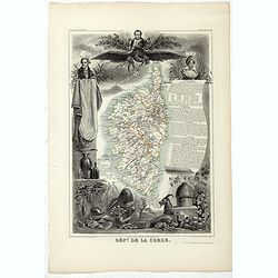
Dépt. De La Corse. N°19.
Map of the Corsica island.Lovely map from one of the last decorative atlases of the nineteenth century.The rather simple map is framed by elaborate border showing regiona...
- $150 / ≈ €129
Date: Paris, A. Combette, 1852