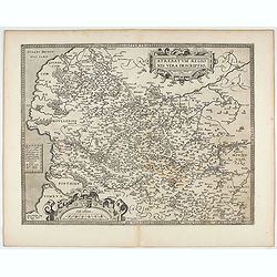
Search Listings matching "dare" in Europe
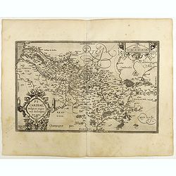
Picardiae Belgicae regionis descriptio
From Theatrum Orbis Terrarum [Atlas of the Whole World]. Prepared by Jean Surhon.Dare to go in Black. All early maps were printed in black and white, and many were kept t...
Place & Date: Antwerp, 1590
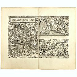
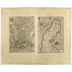
Carinthiae et Goritiae .. / Histria / Zarae / Serebenici. . .
Three maps on one sheet. The left hand is centered on the eastern part of Austria. The right upper hand map is centered on northern Yugoslavia, and the last map is center...
Place & Date: Antwerp, 1598

Hollandiae Antiquorum Catthorum..
This map shows Holland in great detail, including small towns, walled cities, rivers and lakes (many of which were reclaimed in the 17th century, and no longer exist). A ...
Place & Date: Antwerp, 1598

Artois. Atrebatum Regionis Vera Descripto.
Prepared by Jacob Surhon, who made a manuscript map of Artois for which he received 36 Livres from Charles V in 1554. For security reasons, the map was not published. Onl...
Place & Date: Antwerp, 1598

Romaniae, (quae olim Thracia dicta) ..
Very fine map centered on the Danube area. The map is based on the double sheet map by Jacob Gastaldi. Abraham Ortelius (1527-1598) was a cartographer and publisher, who ...
Place & Date: Antwerp, 1598
Moraviae.
This early map of Slovakia was prepared by Paul Fabritius in 1569, centered on the city of Brno. Title cartouche on the upper left corner. Abraham Ortelius (1527-1598) wa...
Place & Date: Antwerp, 1598

Silesiae typus..
Fine and early map of Silesia after Martin Helwig (1516-1574) and used by A.Ortelius in his atlas 'Theatrum Orbis Terrarum [Atlas of the Whole World].Only included in the...
Place & Date: Antwerp, 1598
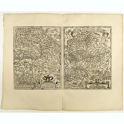
Helvetiae Descriptio . . .
A fine map based upon a map by the Swiss cartographer Aegidicus Tschudi of 1538.Dare to go in Black. All early maps are printed in black and white and many were kept that...
Place & Date: Antwerp, 1598

Florentini Dominii Fidelissima et nova descriptio.
The map is centered on the city of Florence and extends to Liguria, the Apennine Mountains, the Adriatic Coast, Siena and Lago di Perugia. The map is based upon Stefano B...
Place & Date: Anvers, 1598
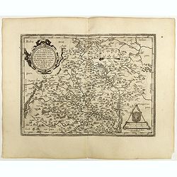
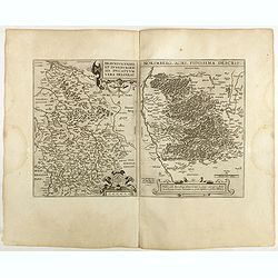
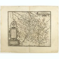
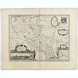
Regionis Biturigum... Per Ioannem Calamaeum. / Limaniae Topographia Gabriele Symeoneo Auct.
Two maps on one sheet. Biturigum. The Loire river is on the right in central France. Neuers (Nevers) is at the middle of the right margin. Bourges is near the center, and...
Place & Date: Antwerp, 1598
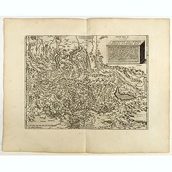
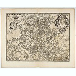
Mansfeldiae Comitatus.
A very fine map centered on the city of Mansfelt . A very nice title cartouche in the upper right corner. Signed by the engraver Franz Hogenberg lower left. Abraham Ortel...
- $75 / ≈ €64
Place & Date: Antwerp, 1598
Basiliensis territorii descriptio nova./Circulus sue Liga. . .
Left-hand map centered on Basel, east to top. With credit to Sebastian Münster in the title cartouche. Right-hand map with Boden See, Strasbourg and Augsburg. The map wa...
- $300 / ≈ €256
Place & Date: Antwerp, 1598
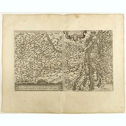
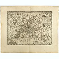
Palatinatvs Bavariae . . . / Argentoratensis agri . . .
From 'Theatrum Orbis Terrarum [Atlas of the Whole World]. The left-hand map of Bavaria is after Erhart Reych's 4-sheet map of 1540. Including the towns of Regensburg, Nü...
- $100 / ≈ €85
Place & Date: Antwerp, 1598
![Larii Lacus Vulgo Comensis Descriptio . . . [and] Terretorii Romani Descrip. [and] Fori Iulii Vulgo Frivli Typus. . .](/uploads/cache/41008-250x250.jpg)
Larii Lacus Vulgo Comensis Descriptio . . . [and] Terretorii Romani Descrip. [and] Fori Iulii Vulgo Frivli Typus. . .
Set of 3 maps of Lake Como, the region around Rome and the region around the Upper Adriatic, centered on Udinese from 'Theatrum Orbis Terrarum [Atlas of the Whole World]'...
Place & Date: Antwerp, 1598
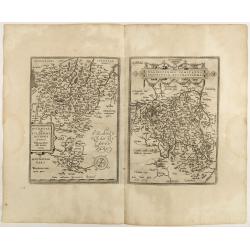
Patavini territorii../ Tarvisini agri typus.. (2 maps on one sheet)
Two maps on one sheet. Map to the left is a detailed map including Venice and the area north of it, including Padua and Vincenza. Very fine map after Giacomo Gastaldi. Th...
- $300 / ≈ €256
Place & Date: Antwerp, 1598
Braunsvicensis et Luneburgensis . . . (together with) Norimberg Agri,..
Two maps on one sheet, showing the regions of Braunschweig and Nuremberg from 'Theatrum Orbis Terrarum [Atlas of the Whole World]': published in Antwerp.Dare to go in Bla...
- $125 / ≈ €107
Place & Date: Antwerp, 1598
Buchaviae / Waldeccensis Comitatus.
Two maps on one sheet. The map on the left is based on Wolfgang Regerwyl's 1574 single fulda map. The map of Waldeck is based on Joist Moers map of 1572. Abraham Ortelius...
- $100 / ≈ €85
Place & Date: Antwerp, 1598
![Blaisois Blesiensis Territorii. . . [together with] - Lemovicum totius et confinium provinciarum. . .](/uploads/cache/40963-250x250.jpg)
Blaisois Blesiensis Territorii. . . [together with] - Lemovicum totius et confinium provinciarum. . .
The map on the left is centered on the Loire with the town of Blois. The right-hand map is centered on Limoges. Dare to go in Black. All early maps were printed in bla...
Place & Date: Antwerp, 1598
Anjou. Andegavensium Ditionis Vera et Integra Descriptio. Licimo Guijeto Andegavense auctore.
Beautiful map of the Anjou region of western France along the Loire River. Include the city of Angers in the center. Accompanying French text on verso. Dare to go in B...
Place & Date: Antwerp, 1598
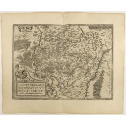
Lutzenburgen sis Ducatus Veriss. Descript.
An attractive map of Luxembourg: title cartouche on the lower left corner. From 'Theatrum Orbis Terrarum [Atlas of the Whole World]'.Iacobo Surhonio Montano auctore. D...
Place & Date: Antwerp, 1598

Gelriae, Cliviae, Finitimorumque Locorum Verissima..
East to the top. Fine map of Geldria and Limburg, prepared by Christian s'Grooten. Very fine title cartouche lower right with painter's utensils around the cartouche. ...
Place & Date: Antwerp, 1598
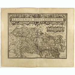
Leodiensis Diocesis Typus.
East to the top. Centered on Liege, including the southern part of Dutch Limburg. Prepared by Jan van Schille.Dare to go in Black. All early maps were printed in black an...
Place & Date: Antwerp, 1598
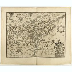
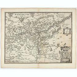
Namurcum Comitatus.
Prepared by Jacques Surhon in 1555. His manuscript map was, for security reasons not published. Only in 1579, when Antwerp was independent for a short time, Ortelius used...
Place & Date: Antwerp, 1598

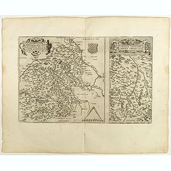
Angliae, scotiae, et Hiberniae, sive Britannicar:insularum.
Fine general map of the British Isles and Ireland on horizontal projection with north to right of page. Derived from Mercator's 1564 map of the British Isles.Dare to go i...
Place & Date: Anwerp, 1598

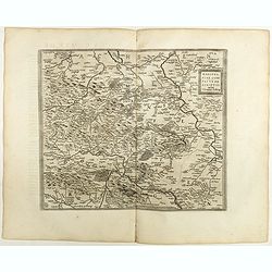
Angliae Regni florentissimi nova descriptio..
Fine general map of England derived from Mercator's 1564 map of the British Isles in 8 sheets.Dare to go in Black. All early maps were printed in black and white; many we...
Place & Date: Antwerp, 1598
Burgundiae inferioris quae Ducatus Nomine Censetur, Des.
Map centered on the province of Burgundy, from 'Theatrum Orbis Terrarum'.Dare to go in Black. All early maps were printed in black and white; many were kept that way for ...
- $100 / ≈ €85
Place & Date: Antwerp, 1598

Regionis Biturigum... Per Ioannem Calamaeum. / Limaniae Topographia Gabriele Symeoneo Auct.
Two maps on one sheet. Biturigum. The Loire river is at the right in central France. Neuers (Nevers) is at the middle of the right margin. Bourges is near the center, an...
- $125 / ≈ €107
Place & Date: Antwerp, ca. 1598

Die Zyp / La Zype.
A miniature map showing the polder of De Zype. Title cartouche in the upper side.First published in 1598 in his Caert-Thresoor, the plates were executed by the most famou...
Place & Date: Amsterdam / Frankfurt, 1609

Hydrograhica descriptio
This very rare chart is important as the first printed sea chart of the Mediterranean coast of Spain, Gibraltar, also depicting the northern coast of Marocco.Willem Bar...
Place & Date: Amsterdam, W.Blaeu, 1612

Flandria.
Very decorative, egg-shaped map. This is the last and very rare third state with the signature Theodorus Galle. The fortifications along the Scheldt River are added and t...
- $1000 / ≈ €855
Place & Date: Antwerp, after 1612
Namurcum Comitatus.
Prepared by Jacques Surhon in 1555. His manuscript map was for security reason not published. Only in 1579, when Antwerp was independent for a short time, Ortelius used a...
- $500 / ≈ €427
Place & Date: Antwerp, after 1612
Artois. Atrebatum Regionis Vera Descripto.
Prepared by Jacob Surhon who made a manuscript map of Artois for which he received 36 Livres from Charles V in 1554. For security reasons the map was not published. Only ...
- $500 / ≈ €427
Place & Date: Antwerp, after 1612

DELFT. Delphium urbs Hollandiae cultissima. . .
A bird's-eye view of the town of Delft. From the first Dutch translation of Guicciardini's description of the Netherlands. In this town-plan, three buildings, still domin...
Place & Date: Amsterdam, 1612
Osnabrugensis Episcopatus.
Originally engraved for Jodocus Hondius II, at his death in August 1629 this map was, among 39 other copper plates, purchased by Willem Blaeu who deleted Hondius' name an...
- $150 / ≈ €128
Place & Date: Amsterdam, 1634
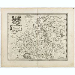
Hassia Landgraviatus.
FIRST EDITION, FIRST ISSUE OF THIS MAP. From the 1634 edition of Blaeu's Atlas Novus, the first edition of this work.Important map of Hesse in Germany, centered on the to...
- $100 / ≈ €85
Place & Date: Amsterdam, 1634

Amstelodamum, Celebre Emporium Forma Plana.
Second state of this rare and decorative plan of Amsterdam with Visscher's imprint. With a panoramic view seen from the IJ and further insets of Council House, The Exchan...
Place & Date: Amsterdam, c. 1636
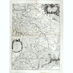
Nobilis Hannoniae Comitatus Descrip.
Fine map of Hannonia (Hainaut), with ornate cartouches, two coats of arms, etc. Showing the cities of Charleroi, Mons, Ath, Tournay, Valenciennes, Maubeuge, etc. in Belgi...
- $600 / ≈ €513
Place & Date: Antwerp, 1612-1641

Pascaart van de west cust van Engeland en Wales Van S. Davids Point tot de Moul van Dalway.
Rare Doncker's sea chart of the Irish Sea with the west Coast of England (Liverpool), the Island of Man and the western-most tip of Northern Ireland (Bangor) and Souther...
Place & Date: Amsterdam, 1660-1668
Il Ducato di Silesia et il Marchesato di Moravia
Scarce two-sheet map of the region along the River Oder in Poland, including parts of Chez Republic and Hungary. Excellent detail throughout. Large and decorative title a...
- $1200 / ≈ €1026
Place & Date: Rome, 1692
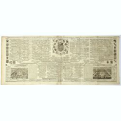
Carte genealogique de la famille Royale de Brunswick . .
A very detailed composite sheet with a genealogical table of the German royal families of Brunswick, Luneburg and Hanover, with descriptive French textZacharie Chatelain ...
- $50 / ≈ €43
Place & Date: Amsterdam, ca. 1720
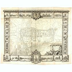
Plan général de Reims et de ses Environs Dédié au Roi.
Rare wall map of a plan of Reims engraved by Jean Lattré. Central cartouche included in the lower border, composed of the coat of arms of France and Navarre, surmounted ...
- $2500 / ≈ €2137
Place & Date: Paris, Lattré, 1769