Browse Listings
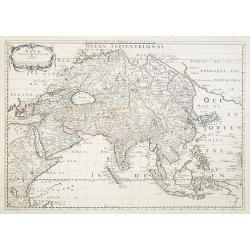
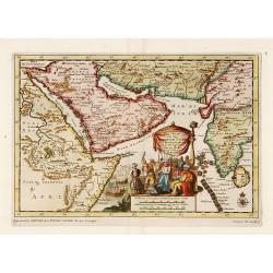
Asie.
Map of Asia still showing Corey as an island. Including Americas West coast.More about Western mapping of Korea maps. [+]
- $500 / ≈ €468
Place & Date: Paris, 1650
![Oceanie. [Manuscript on paper]](/uploads/cache/01830-250x250.jpg)
Oceanie. [Manuscript on paper]
Decorative manuscript map on paper covering South East Asia, Australia and New Zealand.
Place & Date: France ?, ca. 1850
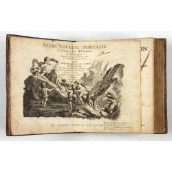
Introduction a la Geographie
Engraved title, with 91 double-page engraved maps mostly including European nations, but including World and continents, Turkey, the Holy Land, Persia, China, Japan, Egyp...
- $3000 / ≈ €2807
Place & Date: Paris, 1756

A chart of the northern part of the Indian Ocean..
Chart of the northern part of the Indian Ocean, including part of Arabia, India and Sri Lanka prepared by D'Apré de Mannevillette and published in London by Laurie and W...
- $750 / ≈ €702
Place & Date: London 1794

Poli Arctici, et circumiacentium terrarum descriptio novissima. . .
A re-issue of the Hondius' plate. A particularly decorative map of the North Pole with Iceland. Several Dutch names in Labrador. The toponymy in Canada reflects the conti...
Place & Date: Amsterdam, 1660

Account of a voyage of discovery to the west coast of Corea.
BRITAIN'S FIRST ACCURATE ACCOUNT OF KOREA & OKINAWANS. With an appendix containing charts and various hydrographical and scientific notices by captain Basil Hall and ...
Place & Date: London, 1818
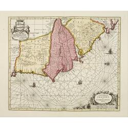
Genehoa Jaloffi et Sierraliones regna.
Decorative and detailed map of the West African Coast, from Senegal to Sierra Leone. In the center the river Gambia to the mouth in the Atlantic. Upper left a dedication ...
Place & Date: Amsterdam, 1670 / 1720
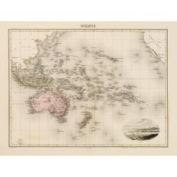
Océanie.
In lower right hand corner a view of Nouméa. Showing the Pacific including California. Engraved by L.Smith.
- $90 / ≈ €84
Place & Date: Paris, 1874

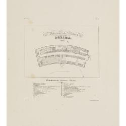
Manuscript map of the Bay of Nagasaki.
An extremely rare manuscript chart in brown ink and wash color on a printed sheet of paper with a system of rhumblines and latitude scales. This chart shows the Bay of Na...
Place & Date: Amsterdam, 1750
-250x250.jpg)
Lyste vande prysen der goederen ingekoft by de Kamer. . .
Rare price list of meat, bacon, wheat, rye, butter, cheese, olive oil, Spanish wines, Bordeaux, brandy etc.On front page in letter press Lyste Van de Pryfen der Goederen,...
Place & Date: Amsterdam, 1685
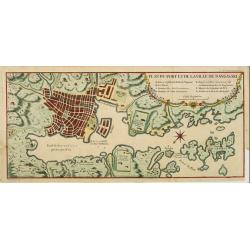
Plan du port et de la ville de Nangasaki.
This plan originates from Charlevoix's work Histoire et description Générele du Japon . His first in 1715 published work was the Histoire de l'etablissement du christia...
- $600 / ≈ €561
Place & Date: Paris, 1760

Manuscript plan of Havana harbour.
Manuscript chart with good nautical detail and soundings of Havana harbour.
Place & Date: Spain c.1820

Bernoise.
A decorative costume print from "Costume de div. Pays", No.17. Engraved by Getine after Lanté.
- $80 / ≈ €75
Place & Date: Paris, c. 1827
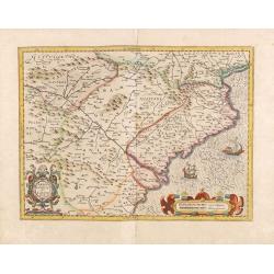
Arragonia et Catalonia.
Aragon and Catalonia. Decorative map with mountain relief and river. 2 finely engraved sailing boats.Mercator was born in Rupelmonde in Flanders and studied in Louvain un...
- $250 / ≈ €234
Place & Date: Amsterdam, 1628
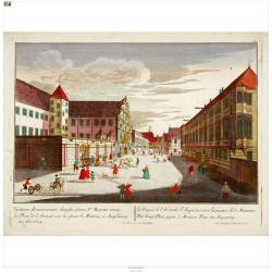
Der Zeug=Platz gegen S.Morizen Plaz zu Augspurg.
A well-known publisher of optical prints, established in Augsburg.In the eighteenth and nineteenth centuries there were many popular speciality establishments in Paris, A...
- $200 / ≈ €187
Place & Date: Augsburg, 1760
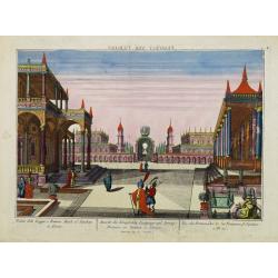
Vue des Promenades et les Fontaines d'Ispahan.
Carmine was a well-known publisher of optical prints, established in Augsburg.In the eighteenth and nineteenth centuries there were many popular specialty establishments ...
- $250 / ≈ €234
Place & Date: Augsburg 1770
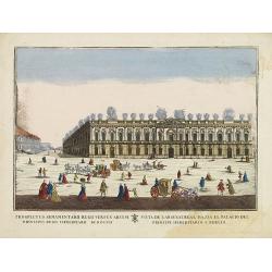
(Berlin) Prospectus Armamentarii regnii versus arcem principis regis haereditarii Berolini.
A square in Berlin. In the eighteenth and nineteenth centuries there were many popular speciality establishments in Paris, Augsburg and London which produced optical view...
- $200 / ≈ €187
Place & Date: Italy, 1770
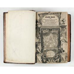
Cruydt-Boeck van Remberus Dodonaeus. . .
Scarce, the last edition of Dodoens' Cruydt-Boeck, one of the most influential and important botanical works of the 16th and 17th centuries. With richly engraved frontisp...
Place & Date: Leyden, 1612

A ship's hour glass
The element common to celestial position-finding, the calculation of speed for dead reckoning and even everyday life at sea is the time: hence ways of determining and kee...
Place & Date: ca. 1790
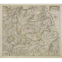
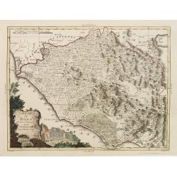
Nova Totius Westphaliae descriptio.
Map of the northern provinces of Germany, including the Wad islands. West to the top. Including Bremen, Hildesheim, Kassel, Düsseldorf, etc. Also including the Dutch pro...
Place & Date: Amsterdam, 1680

Hassia Landgraviatus.
Centered on the town of Kassel.
Place & Date: Amsterdam, 1650

Tabula comitatus Hollandiae. . .
Fine map of the provinces of North and South Holland. In upper left hand corner an inset with the islands of Texel and Vlieland.
Place & Date: Augsburg 1760
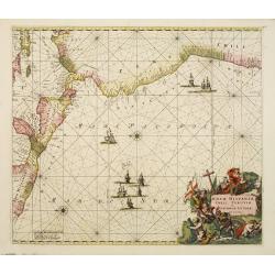
Nova Hispaniae, Chili, Peruviae, et Guatimalae Littorae..
A superbly decorative chart, oriented with north to the left of the sheet, covering the coasts of Central America, Peru, Chile, Jamaica and part of Cuba and Porto Rico. S...
- $1000 / ≈ €936
Place & Date: Amsterdam, 1660
Nederlandsche Factory DEZIMA 1828.
Bird's-eye view of the manmade island of Deshima, a trading post of the V.O.C. from 1641 onward.Underneath the map a legend in Dutch and German with names of all the buil...
Place & Date: Leiden, 1832-1852
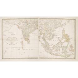
Charte von Ostindien Diesseits Und Jenseits Des Ganges / nach den neuesten astronomischen Beobachtungen auch andern sichern Hülfsmitteln neu entworfen. . .
Prepared by I.C.M.Reinecke giving good detail in India, Indonesia and the Philippines.
- $800 / ≈ €749
Place & Date: Weimar, 1822

Carte de la Manche. . .
Decorative chart showing the Chanel, with the coastline of France from La Baie de Douarnenez to Dunkerque, and the coastline of England from Stroble head to Manning Tree....
Place & Date: Amsterdam, 1692
Carte d'Amerique dressée par Pierre Tardieu. . .
Detailed map prepared by Pierre Tardieu. With good detail on Alaska. Including New Zealand.
- $450 / ≈ €421
Place & Date: Paris, 1831
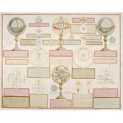
Analytique des différentes positions de la Sphère, des différens systemes, des révolutions et des distances des Planètes, &c
Containing "Globe Celeste", "Sphere de Copernic", "Globe Terrestre", "Systeme de Ptolomee" ; including diagrams of the solar syste...
Place & Date: Paris, 1780

Carte de la Baye et du Port de Trinquemalay dans L'Isle de Ceylan.
Chart showing the bay of Trincomalee, Ceylon (Sri Lanka). Trincomalee is natural deep water port on the east coast of Sri Lanka, about 110 miles northeast of Kandy. It is...
- $250 / ≈ €234
Place & Date: Paris, 1775
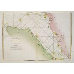
Carte Plate de la partie Septentrionale du Detroit de Malac, depuis de la rade d'Achem jusqu'a Malac.
French chart of the Island of Sumatra and the Malay Peninsula separated by the strait of Malacca in Indonesia.Latitude and longitude scales, compass rose and system of rh...
- $500 / ≈ €468
Place & Date: Paris, ca. 1775

Belgium Foederatum emendate auctum et novissimé editum.
Fine detailed map of the area of the modern Netherlands less the southern part of Limburg. Title cartouche representing the commerce, the arts and the sciences. The Lion ...
Place & Date: Amsterdam, 1680
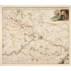
Comitatus Namurci Tabula in Lucem. . .
Centered on Namen, with decorative title cartouche upper right.
Place & Date: Amsterdam, 1680
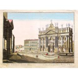
Tempum S.Joannis in Laterano Romae. . .
A so-called optical print. In the eighteenth and nineteenth centuries there were many popular specialty establishments in Paris, Augsburg and London which produced optica...
- $150 / ≈ €140
Place & Date: Italy, ca.1780
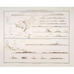
Küstenansichten von Japan bis Capstadt und St. Helena in 5 Blättern.
Prepared by Officer S.M.S. Arcona during the German expedition of 1860-1861 to South East Asia. Lithographed by Lippold and printed by C.Ulrich of Berlin. Sheet 2 from a ...
Place & Date: Berlin, 1863
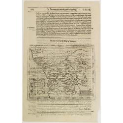
Congi regnu.
Samuel Purchas' edition of the Mercator/Hondius Atlas Minor . Early map of Congo published in his famous collection of voyages His Pilgrimes . With descriptive text in En...
- $100 / ≈ €94
Place & Date: London, 1645
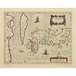
Japoniae Nova Descriptio.
The map is identical in cartographic detail to the Hondius map of 1606 but newly designed ornate cartouches have been added. The three main islands of Japan are shown wit...
- $1800 / ≈ €1684
Place & Date: Amsterdam 1650
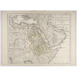
Carte de L'Egypte de la Nubiede L'Abissinie. . .
Including the Arabian Peninsula. Giving good detail on Egypt. Engraved by Desrosiers.More about Mapping of Arabia [+]
- $300 / ≈ €281
Place & Date: Paris, 1707
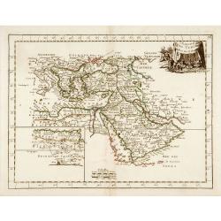
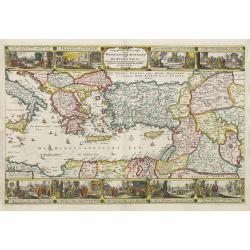
L'Empire des Turcs.
With decorative title cartouche upper right. Good detail in the Arabian peninsula.More about Mapping of Arabia [+]
- $240 / ≈ €225
Place & Date: Paris, 1767
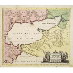
Maris Assoviensis vel de Zabache et Paludis Maeotidis. . .
A very detailed map showing the Black Sea, Azow and Rostow area.
Place & Date: Augsburg, 1720
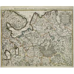
Carte de Moscovie. . .
Centred on Moscow, including Lapland. With fine uncolored title cartouche.
Place & Date: Amsterdam, 1720
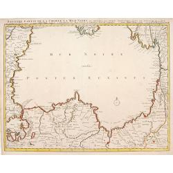
Seconde partie de la Crimee la Mer Noire. . .
The lower part of a set of two maps from the observations of Guillaume Delisle focuses on the Black Sea with wonderful detail of the surrounding regions. Includes Constan...
- $500 / ≈ €468
Place & Date: Amsterdam, 1720
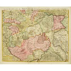
Partie Meridionale de Moscovie..
Centered on Moscow, including Azow in the bottom part of the map.The Amsterdam publishing firm of Covens and Mortier (1721 - c. 1862) was the successor to the extensive p...
- $300 / ≈ €281
Place & Date: Amsterdam 1720
Zee-Togt van den Grooten Turk Uyt het Roode Meyr Tegen de Portugy fen na Indien tot aan Kaap Comorin Ondernomen.
Map of the Arabian peninsula, with Saudi Arabia, the Indian Ocean and India and Ceylon.Although not renowned for the originality of his work, Pieter van der Aa is highly ...
- $600 / ≈ €561
Place & Date: Leiden, 1706
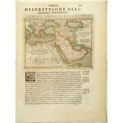
Turcici Imperii descriptio.
Finely and early map of the Turkish Empire giving good detail in the Arabian Peninsula. From Isolario, engraved by Girolamo Porro.Read more about Mapping of Arabia and o...
Place & Date: Padua, 1620
Selling price: $300
Sold in 2008
Geographische Beschryvinghe van de wandeling der apostelen ende De Reysen Pauli. . .
In upper and lower part 9 vignettes showing scenes from Paul's wanderings.
- $500 / ≈ €468
Place & Date: Amsterdam, 1660
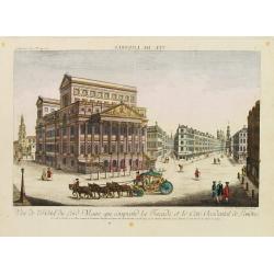
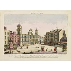
Vue de l'Hotel du Lord Maire, qui comprend.. (London)
In the eighteenth and nineteenth centuries there were many popular speciality establishments in Paris, Augsburg and London which produced optical viewing devices and spec...
- $300 / ≈ €281
Place & Date: Augsburg 1750
Vue de la Maison de Northumberland a Charing Cross. . .
In the eighteenth and nineteenth centuries there were many popular speciality establishments in Paris, Augsburg and London which produced optical viewing devices and spec...
- $300 / ≈ €281
Place & Date: Augsburg 1750
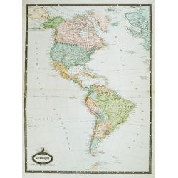
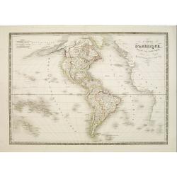
Amérique. . .
Very detailed map from Atlas Sphérodidal & Universel de géographie , Prepared by F.A.Garnier and edited by Jules Renouard, rue de Tournon, Paris. With decorative ti...
- $300 / ≈ €281
Place & Date: Paris, 1861
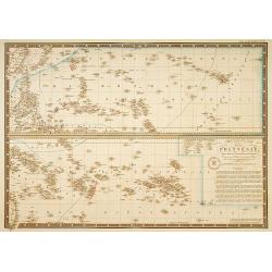
Les divers archipels de L'Oceanie.
Very detailed map from Atlas Sphéroïdal & Universel de geographie , Prepared by F.A.Garnier and edited by Jules Renouard, rue de Tournon, Paris. Uncommon map with d...
- $150 / ≈ €140
Place & Date: Paris, 1861

Les Provinces confederées du Pais-Bas
The first wall map of the Seven Provinces of 1651, re-issued as 'Stoel des Oorlogs' by Covens & Mortier. The first issue of the present wall-map is known to be includ...
Place & Date: Amsterdam, c. 1740
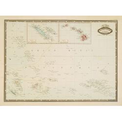
Carte particuliere de la Polynesie. . .
Prepared by A.Brué in 1826 and published by Charles Piquet. Two maps on one sheet, showing the Polynesian islands. In upper left an inset map of Formosa and the coast o...
- $150 / ≈ €140
Place & Date: Paris, 1834
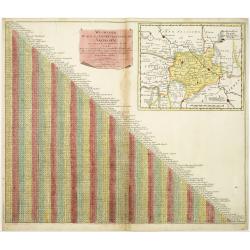
Wegweiser duch das Chiurfurstenthumb Sachen.
Showing distances in-between towns in Saxen, Germany. In upper right hand corner inset map of Saxen, showing Leipzig, Dresden, Prague.More about cartographical curiositie...
- $75 / ≈ €70
Place & Date: Amsterdam 1720
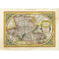
Comitatus Hannonia.
Detailed map of the Belgium province Hainault or Henegouwen. Including the towns of Mons, Geraadsbergen, etc.Uncommon and decorative oval map in a rectangular frame, the ...
- $100 / ≈ €94
Place & Date: Amsterdam, 1616
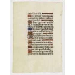
Leaf on vellum from a manuscript Book of Hours.
VERSO: one 2-line illuminated initial showing a bird in fine detail in liquid gold on colored ground, seven 1-line initials and line-fillers in same.RECTO: Seven 1-line i...
Place & Date: France, c. 1520

Lion and Bull made of terracotta.
Very fine terracotta figure of a lion symbolizing the continent of Africa. The Bull symbolizing Europe.The items will be dispatched in 4 wooden crates from Belgium. Pleas...
Place & Date: Netherlandisch , 1780~1800

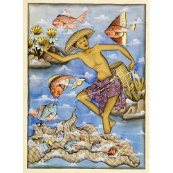
Balinees watercolor on paper, fishermen.
Decorative export painting from Bali of a more than average quality.
- $150 / ≈ €140
Place & Date: Bali, ca 1960

Balinees watercolor on paper, fisherman.
Decorative export painting from Bali of a more than average quality.
- $150 / ≈ €140
Place & Date: Bali, ca 1960
Balinees watercolor on paper, fishermen.
Decorative export painting from Bali of a more than average quality.
- $150 / ≈ €140
Place & Date: Bali, ca 1960

Vue de L'Hotel de Batavie. . .
A so-called optical print of Fatahillah Square in Jakarta, Indonesia, prepared for use in a light-box or an amusing light-show. This richly hand colored print is much per...
Place & Date: Augsburg, 1750
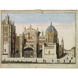
Vüe de L'Eglise Cathedrale de Tolede.
A so-optical print of a church in Toledo, Spain, prepared for use in a light-box or an amusing light-show. This richly hand colored print is much perforated, windows are ...
Place & Date: Italy ca 1780

Launa vulgo Laun Bohemiae civitas.
Bird's-eye views of Louny in Bohemia by G. Hoefnagel. The copperplate was made for Braun and Hogenberg's town book. However there the print has been transformed by the en...
Place & Date: The Hague, 1700

Schlanium vulgo Schlani Bohemiae oppidum.
Very decorative and rare panoramic town view of Schlan, Schlanium s. Slany.The engraver and publisher of prints, Mrs. Anna Beek of the Hague, enlarged this print, origina...
Place & Date: The Hague, 1700
Campagna di Roma Di nuova Projezione. . .
A very striking map of the area south east of Rome, engraved by G.Pitteri embellished with an colored pictorial title cartouche.
Place & Date: Venice, 1798
Selling price: $200
Sold in 2015
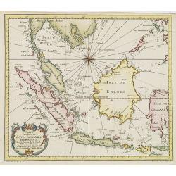
Carte Des Isles de Java, Sumatra, Borneo.. Malaca et Banca..
Jacques Nicolas Bellin (1703-1772) was one of the most important and proficient French cartographers of the mid-eighteenth century. He was appointed the first Ingenieur H...
- $300 / ≈ €281
Place & Date: Paris, 1752
India Orientalis.
The rare Samuel Purchas' edition of the Mercator/Hondius Atlas Minor atlas map. Thisearly map of the East Indies was published in his famous collection of voyages His Pil...
- $300 / ≈ €281
Place & Date: London, 1625
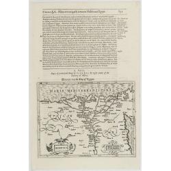
Aegyptus.
The rare Samuel Purchas' edition of the Mercator/Hondius Atlas Minor atlas map. Early map of Egypt published in his famous collection of voyages His Pilgrimes . With desc...
- $150 / ≈ €140
Place & Date: London, 1625
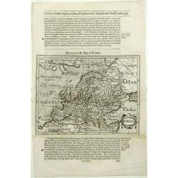
Europa.
The rare Samuel Purchas' edition of the Mercator/Hondius Atlas Minor atlas map. Early map of Europe published in his famous collection of voyages His Pilgrimes . With des...
- $150 / ≈ €140
Place & Date: London, 1625
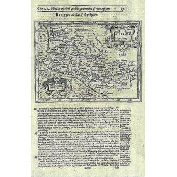
Hispania Nova.
The rare Samuel Purchas' edition of the Mercator/Hondius Atlas Minor atlas map. This was the standard map of the area for a generation. The map shows an area correspondin...
- $100 / ≈ €94
Place & Date: London, 1625
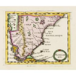
Magellani Que.
Uncommon miniature map of Argentina and Strait of Magellan from Pierre Duval's La Geographie Universeille dated 1676. Following his Cartes de geographie in 1657, Pierre D...
- $200 / ≈ €187
Place & Date: Paris, 1676
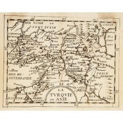
La Turquie en Asie.
Uncommon miniature map of Turkey, Cyprus, Palestine, Iran, and Iraq. From Pierre Duval's "La Geographie Universeille" dated 1676. Following his "Cartes de ...
- $75 / ≈ €70
Place & Date: Paris, 1676
![Noweav Mexiqve [California as an Island]](/uploads/cache/03796-250x250.jpg)
Noweav Mexiqve [California as an Island]
Uncommon miniature map of California as a island, from Pierre Duval's La Geographie Universeille in a second state. The map is derived from Audience de Guadalajara (1657)...
Place & Date: Paris, 1663
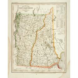
Neueste Karte von New Hampshire und Vermont.
Detailed map of New Hampshire and Vermont with numerous physical and political features including mines, settlements, trails/roads, forts and Indian areas. From Meijers H...
- $150 / ≈ €140
Place & Date: Hildburghausen/ Philadelphia, 1846
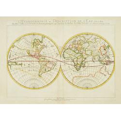
L'Hydrographie ..la Surface du Globe Terrestre.
An unusual double hemisphere hydrological map of the world - the earliest of the world prepared by the great French mapmaker Nicolas Sanson. Of particular interest is the...
- $750 / ≈ €702
Place & Date: Paris, 1652

Slusa, Teutonicae Flandriae opp. . . (Sluis)
Bird'eye view of the town of Sluis.From the greatest publication in this genre!. The Civitates was compiled and written by George Braun, Canon of Cologne Cathedral. Braun...
Place & Date: Cologne, 1580
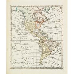
Amerika
Scarce miniature map of the Western Hemisphere.
- $200 / ≈ €187
Place & Date: Augsburg, 1824
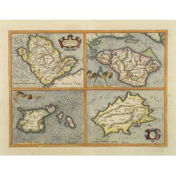
Anglesey. / Iarsay. / Carnesay. / Wight Vectis Olim.
Four maps on one sheet depicting the English islands Jersey, Guernsey, Wright and Alderney.
Place & Date: Amsterdam, 1629

Vue du Magazin de la Compagnie des Indes Orientales. . .
So-called optical print of the formerly the V.O.C. warehouse and arsenal for the Admiralty of Amsterdam, now-a-days the Scheepvaartmuseum (Maritime Museum).In the eightee...
Place & Date: France, 1780
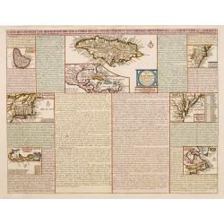
Carte qui contient..Iles & Terres..L'Amerique..Jamaique..
Eight maps on one sheet. From Chatelain's Atlas Historique et Méthodique . Including maps of Bermuda, Jamaica, New England with Long Island, Carolina, Chesapeake and Del...
Place & Date: Amsterdam, 1728
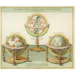
Sphaera Artificialium Typica repraesentatio.
Stunning engraving of terrestrial and celestial globes and armillary sphere, all with highly ornamented stands. Brief explanatory text. The plate was based on a design by...
Place & Date: Augsburg, 1730
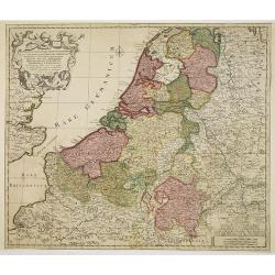
Septendecm. Provinciae Germaniae Inferior. . .
A general map of the Netherlands, Luxembourg and Belgium. Fine title cartouche showing Mercury, Neptune, globe, etc. Lower right coat of arms of 17 Provinces.
- $150 / ≈ €140
Place & Date: Amsterdam, 1700