Browse Listings in Australia & Oceania
![[Australia and Polynesia].](/uploads/cache/46141-250x250.jpg)
[Australia and Polynesia].
Alexey Afinogenovich Ilyin was a lieutenant general and cartographer (1832-1889). In 1856, after graduating from the Academy of the General Staff, he was at the military ...
- $150 / ≈ €140
Place & Date: St. Petersburg, 1899
![Terre de Diemen. Bara-Ourou. [plate VIII]](/uploads/cache/46271-250x250.jpg)
Terre de Diemen. Bara-Ourou. [plate VIII]
A portrait of the Tasmanian Aboriginal Bara-Ourou, after the original sketches by Lesueur, from Voyage de découvertes aux terres Australes by François Péron, 1824.The ...
- $150 / ≈ €140
Place & Date: Paris, 1824
![Terre de Diemen. Ourlaga. [plate IX]](/uploads/cache/46272-250x250.jpg)
Terre de Diemen. Ourlaga. [plate IX]
A portrait of the female Tasmanian Aboriginal Ourlaga, after the original sketches by Lesueur, from Voyage de découvertes aux terres Australes by François Péron, 1824....
- $150 / ≈ €140
Place & Date: Paris, 1824
![Terre de Diemen. Grou-Agara. [plate X]](/uploads/cache/46273-250x250.jpg)
Terre de Diemen. Grou-Agara. [plate X]
A portrait of the Tasmanian Aboriginal Grou-Agara, after the original sketches by Lesueur, from Voyage de découvertes aux terres Australes by François Péron, 1824.The ...
- $100 / ≈ €94
Place & Date: Paris, 1824
![Terre de Diemen. Paraberi. [plate XI]](/uploads/cache/46274-250x250.jpg)
Terre de Diemen. Paraberi. [plate XI]
A portrait of the Tasmanian Aboriginal Paraberi, after the original sketches by Lesueur, from Voyage de découvertes aux terres Australes by François Péron, 1824.The Fr...
- $200 / ≈ €187
Place & Date: Paris, 1824
![Terre de Diemen. Arra-Maida. [plate XII]](/uploads/cache/46275-250x250.jpg)
Terre de Diemen. Arra-Maida. [plate XII]
A portrait of a female Tasmanian Aboriginal Arra-Maida, after the original sketches by Lesueur, from Voyage de découvertes aux terres Australes by François Péron, 1824...
- $100 / ≈ €94
Place & Date: Paris, 1824
![Terre de Diemen. Habitations. [plate XV].](/uploads/cache/46278-250x250.jpg)
Terre de Diemen. Habitations. [plate XV].
An aboriginal camp fire, near the ruins of an old wooden fence, and a dead tree, after the original sketches by Lesueur, from Voyage de découvertes aux terres Australes ...
- $200 / ≈ €187
Place & Date: Paris, 1824
![Terre de Diemen. Tombeaux des naturels. [plate XVI]](/uploads/cache/46279-250x250.jpg)
Terre de Diemen. Tombeaux des naturels. [plate XVI]
An aboriginal campfire, near the ruins of an old wooden fence, and a dead tree, after the original sketches by Lesueur, from Voyage de découvertes aux terres Australes b...
Place & Date: Paris, 1824
![Nouvelle-Hollande. Gnoung-A-Gnougn-A, Mour-Re-Mour-Ga ( Dit Collins). [plate XVII]](/uploads/cache/46280-250x250.jpg)
Nouvelle-Hollande. Gnoung-A-Gnougn-A, Mour-Re-Mour-Ga ( Dit Collins). [plate XVII]
A portrait of a male Tasmanian Aboriginal Gnoung-A-Gnougn-A, Mour-Re-Mour-Ga ( Dit Collins) by Lesueur, from Voyage de découvertes aux terres Australes by François Pér...
- $100 / ≈ €94
Place & Date: Paris, 1824
![Nouvelle-Hollande - Y-Erran-Gou-La-Ga. [plate XIX]](/uploads/cache/46341-250x250.jpg)
Nouvelle-Hollande - Y-Erran-Gou-La-Ga. [plate XIX]
A portrait of a male Tasmanian Aboriginal Y-Erran-Gou-La-Ga by Lesueur, from Voyage de découvertes aux terres Australes by François Péron, 1824.The French expedition u...
- $150 / ≈ €140
Place & Date: Paris, 1824
![Nouvelle-Hollande: Nelle Galles du sud - Norou-Gal-Derri s'avancant pour combattre. [plate XX]](/uploads/cache/46342-250x250.jpg)
Nouvelle-Hollande: Nelle Galles du sud - Norou-Gal-Derri s'avancant pour combattre. [plate XX]
A portrait of a male Tasmanian Aboriginal Norou-Gal-Derri by Lesueur, from Voyage de découvertes aux terres Australes by François Péron, 1824.The French expedition und...
- $200 / ≈ €187
Place & Date: Paris, 1824
![Nouvelle-Hollande: Nelle. Galles du sud - Navigation. [plate XXIII]](/uploads/cache/46345-250x250.jpg)
Nouvelle-Hollande: Nelle. Galles du sud - Navigation. [plate XXIII]
An aboriginal camp fire, with a pirogue and two men navigating , after the original sketches by Lesueur, from Voyage de découvertes aux terres Australes by François Pé...
- $300 / ≈ €281
Place & Date: Paris, 1824
![Nouvelle-Hollande: Terre dEndracht - Cabane des naturels de la Presqu'Ile de Péron. [plate XXIV]](/uploads/cache/46346-250x250.jpg)
Nouvelle-Hollande: Terre dEndracht - Cabane des naturels de la Presqu'Ile de Péron. [plate XXIV]
An aboriginal camp fire, after the original sketches by Lesueur, from Voyage de découvertes aux terres Australes by François Péron, 1824.The French expedition under Ni...
- $300 / ≈ €281
Place & Date: Paris, 1824
![Nouvelle-Hollande: Ile Bernier. - Kanguroo a Bandes [plate XXVII]](/uploads/cache/46349-250x250.jpg)
Nouvelle-Hollande: Ile Bernier. - Kanguroo a Bandes [plate XXVII]
Plate illustrating Kanguroo a Bandes by Lesueur, from Voyage de découvertes aux terres Australes by François Péron, 1824.The French expedition under Nicolas Baudin, wa...
- $300 / ≈ €281
Place & Date: Paris, 1824
![Nouvelle-Hollande: Ile King. - L'Eléphant -marin ou Phoque à trompe. [plate XXXII]](/uploads/cache/46354-250x250.jpg)
Nouvelle-Hollande: Ile King. - L'Eléphant -marin ou Phoque à trompe. [plate XXXII]
Plate illustrating seals by Lesueur, from Voyage de découvertes aux terres Australes by François Péron, 1824.The French expedition under Nicolas Baudin, was commission...
- $300 / ≈ €281
Place & Date: Paris, 1824
![Nouvelle-Hollande: Nouvelle Galles du sud. -Dasyure à longue queue. [plate XXXIII]](/uploads/cache/46355-250x250.jpg)
Nouvelle-Hollande: Nouvelle Galles du sud. -Dasyure à longue queue. [plate XXXIII]
Plate illustrating the Dasyure, who lives in Tasmania and south-eastern Australia. Plate by Lesueur, from Voyage de découvertes aux terres Australes by François Péron,...
- $200 / ≈ €187
Place & Date: Paris, 1824
![Nouvelle-Hollande Nelle Galles du sud. Vue d'une partie de la ville de Sydney capitale des Colonies Anglaises aux Terres Australes . . . [plate XXXVII]](/uploads/cache/46359-250x250.jpg)
Nouvelle-Hollande Nelle Galles du sud. Vue d'une partie de la ville de Sydney capitale des Colonies Anglaises aux Terres Australes . . . [plate XXXVII]
Important view of Sydney Cove from Dawes Point looking eastward from Voyage de découvertes aux terres Australes by François Péron, 1824. This is one of the earliest de...
- $1100 / ≈ €1029
Place & Date: Paris, 1824
![Nouvelle-Hollande: Ile Decrès. - Détails du Casoar de la Nouvelle Hollande. [plate XLL]](/uploads/cache/46362-250x250.jpg)
Nouvelle-Hollande: Ile Decrès. - Détails du Casoar de la Nouvelle Hollande. [plate XLL]
Plate illustrating Casoar, by Lesueur, from Voyage de découvertes aux terres Australes by François Péron, 1824.The French expedition under Nicolas Baudin, was commissi...
- $75 / ≈ €70
Place & Date: Paris, 1824
![Plan de la partie sud des Iles Furneaux [with] Carte générale de la Partie Sud-Est de la Terre de Diémen . . .](/uploads/cache/46365-250x250.jpg)
Plan de la partie sud des Iles Furneaux [with] Carte générale de la Partie Sud-Est de la Terre de Diémen . . .
Two maps on one sheet, on top a map of the southern portion of Cape Barren Island, Clarke Island, and islets in the southern part of the Furneaux Group.With in lower part...
- $200 / ≈ €187
Place & Date: Paris, 1824
![Plan d'une partie de la Terre Napoléon [with] Plan des Iles Joséphine et de la Baie Murat.](/uploads/cache/46367-250x250.jpg)
Plan d'une partie de la Terre Napoléon [with] Plan des Iles Joséphine et de la Baie Murat.
Two maps showing Descartes Bay and Bridgewater Bay in Victoria and Murat Bay in South Australia showing French discoveries prepared by Louis Freycinet during his voyage u...
- $100 / ≈ €94
Place & Date: Paris, 1807-1816
![Plan des Iles Jérôme [with] Plan des Iles Berthier [with] Plan du Comté de Cumberland.](/uploads/cache/46370-250x250.jpg)
Plan des Iles Jérôme [with] Plan des Iles Berthier [with] Plan du Comté de Cumberland.
Three maps on one sheet, Jérôme islands, Berthier islands and Cumberland county, from Voyage de découvertes aux terres Australes by François Péron, 1824. The French ...
- $100 / ≈ €94
Place & Date: Paris, 1807-1816
![Plan du Port du Roi-George [with] Plan de la Baie du Geographe.](/uploads/cache/46371-250x250.jpg)
Plan du Port du Roi-George [with] Plan de la Baie du Geographe.
Two maps on one sheet, King George Sound and Geographe Bay, now Busselton and Dunsborough area and the earliest chart of this area, from Voyage de découvertes aux terres...
- $500 / ≈ €468
Place & Date: Paris, 1807-1816
![Plan de la Baie Laplace [with] Esquisse du Port Western [with] Plan des Iles Forestier [with] Esquisse du Port Champagny.](/uploads/cache/46372-250x250.jpg)
Plan de la Baie Laplace [with] Esquisse du Port Western [with] Plan des Iles Forestier [with] Esquisse du Port Champagny.
Four maps on one sheet, Laplace Bay, Western Harbour, Forestier islands and Champagny Harbour, from Voyage de découvertes aux terres Australes by François Péron, 1824....
- $200 / ≈ €187
Place & Date: Paris, 1824

Kaart Van Nieuw Zeeland in de Jaaren 1769 en 1770 bezogt door den Luitenant J. Cook met het Schip De Endeavour.
A uncommon issue of this key map of New Zealand from the Dutch edition of Cook's map of New Zealand, published in 'Reize rondom de Waereld door James Cook', a Dutch editi...
Place & Date: Leyden, Amsterdam & The Hague: Honcoop, Allart & van Cleef, 1795-1801
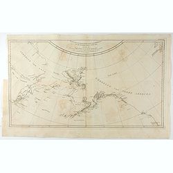
Kaart van de Noord-West kust van Amerika en de Noord-Oost kust van Asia. . .
A uncommon issue of this important map of the Northern Pacific and contiguous coasts of America and Asia, published in 'Reize rondom de Waereld door James Cook', a Dutch ...
- $1000 / ≈ €936
Place & Date: Leyden, Amsterdam & The Hague: Honcoop, Allart & van Cleef, 1795-1801
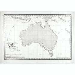
Carte Generale de la Nouvelle Hollande.
Fine map of the continent of Australia prepared by Louis Freycinet during his voyage under Captain Thomas Baudin in 1800-1803. Freycinet's map of New Holland was the firs...
- $5000 / ≈ €4679
Place & Date: Paris, Imprimerie Royale, 1811
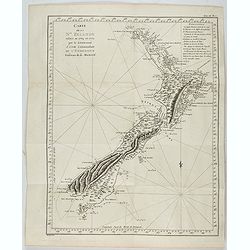
Carte de la Nouvelle-Zelande visitée en 1769 et 1770 par le Lieutenant J. Cook.
Original French Edition of James Cook's Chart of New Zealand, from the First French Edition of Hawkesworth's Voyages. Map of New Zealand, engraved by Bernard. The most im...
Place & Date: Paris, 1774
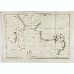
Carte de l'Entrée de Norton, et du Detroit de Bhering ou Von vou le Cap le plus oriental de l'Asie, et la Pointe la plus occidentale de l'Amerique.
Early detailed map of the passage between Asia and the NW Coast of America, including nice topographical details and the day by day tracks of Cook through the region in 1...
- $300 / ≈ €281
Place & Date: Paris, 1785

Voyage de découvertes aux Terres Australes. Historique. Atlas Deuxième partie.
First edition of the second part of the atlas by Freycinet, part of his important book "Voyage de découvertes aux Terres Australes". Illustrated with two foldi...
- $7500 / ≈ €7018
Place & Date: Paris, Langlois, 1811
![[Collection of six maps of Australia and New Zealand.]](/uploads/cache/48412-250x250.jpg)
[Collection of six maps of Australia and New Zealand.]
Collection of maps including 6 engraved maps by 19th century German, French and English cartographers depicting Australia and New Zealand.This made to order atlas contain...
Place & Date: Germany, 1832-1852
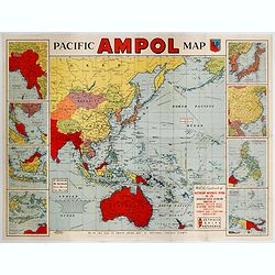
Pacific AMPOL Map
A large and very colorful World War II era map of the Pacific Ocean produced with the complements of the Australian Motorists Petrol Co. Ltd. The map itself shows the Pac...
- $1000 / ≈ €936
Place & Date: Australia, ca 1942
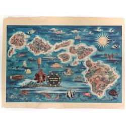
The Dole Map of the Hawaiian Islands.
A terrific, colorful poster of the Hawaiian Islands by Joseph Feher, commissioned for the Hawaiian Pineaple Co. The poster displays all eight of the major islands in the ...
- $250 / ≈ €234
Place & Date: USA, 1950