Browse Listings in Atlases

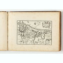
Composite atlas of the Low Countries.
A composite atlas comprising 18 double-page engraved maps by or after Hessel Gerritsz, Theodoor Galle, Jacob van Deventer, Gerard Mercator, Peter Verbiest, Jean Surhon, C...
Place & Date: [Antwerp, c. 1633
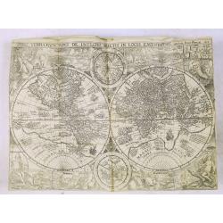
Carte Generalles des Royaumes & Provinces, de la haute et basse Allemagne, Reveües et Corigées, par le Sr. Tassin, Geographe Ordinaire de Sa Ma.té.
Illustrated with 51 (of 52) maps of The Netherlands, Belgiem, Germany, France, Poland, Bohemia...Christophe Tassin, who was active from 1633 till 1655, was appointed 'roy...
Place & Date: Paris, [Sébastien Cramoisy], 1633
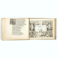
La Flamboyante Colomne des Pays-Bas. Autrement dict les XVII Provinces. Chez Jacob Colom.
Rare atlas of the Low Countries, by Jacob Colom, in an early – first- French edition. The atlas was first printed in Dutch (1635) and than in 1636 in French, using the ...
- $3000 / ≈ €2807
Place & Date: Amsterdam, 1636
Histoire de la Navigation.
A fine example of Linschoten's classic illustrated travelogue to the East and West Indies, termed by Lach “the most important of the firsthand accounts published indepe...
Place & Date: Amsterdam, Evert Cloppenburgh, 1638
![[Two vomlumes, with two Leo maps] De Bello Belgico, Decas Prima / Decas Secunda.](/uploads/cache/48779-250x250.jpg)
[Two vomlumes, with two Leo maps] De Bello Belgico, Decas Prima / Decas Secunda.
With 2 engraved titles of the 'Leo Belgicus', with one paw resting on a shield bearing the title, large woodcut printer's device on the colophons, and 30 richly engraved ...
Place & Date: Rome, Franciscus Corbelletus, 1632-1647
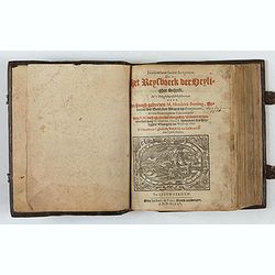
Itinerarium Sacrae Scripturae, dat is, Het Reysboeck der heyligher Schrift
This is a scarce 1648 Dutch edition of Büntings "Itinerarium Sacrae Scripturae" printed in Leeuwarden. The book includes 6 folding maps and 2 plates. The book ...
- $3000 / ≈ €2807
Place & Date: Leeuwarden, de Vries, Jan Jansz., 1648

Chorographica descriptio provinciarum, et conventum fratrum minorum S. Francisci Capucinorum...
All maps are good and dark impressions. Several maps with slight foxing and browning, the folding map with 2 splits (top right part 10 cm and lower left part 6 cm into en...
Place & Date: Turin, 1649
Geographisches-Toneel, Of uitgezochte kaarten, Tot gemak der Officieren, Reisigers en Liefhebbers.
Pocket atlas, not in Koeman, but similar to Koeman III, p. 99 (Rat 1) of which our atlas is a later edition.Illustrated with 41 engraved maps, of which two are in origina...
- $2000 / ≈ €1871
Place & Date: Amsterdam, D. Weege, 1653
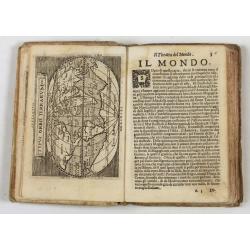
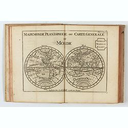
Theatro del Mondo di Abrahamo Ortelio..
Including maps of the world (Shirley, World 214): Europe; Asia; America (Burden, America 126, Marchetti 1598); Africa; England; Scotland; Ireland; Tercera; Spain (4); Por...
Place & Date: Venice, G. Turrini, 1655
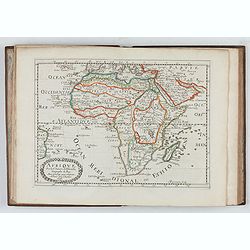
L'Affrique En Plusieurs Cartes Nouvelles, et exactes, &c.
Edition illustrated with 18 maps in original outline colors dated 1656. No date and title page and maps not numbered (according to Pastoureau 1 C, maps are numbered).Nico...
Place & Date: Paris, l'Auteur, after 1662