Browse Listings in Asia > Tartary / Siberia
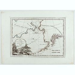
Le Coste Nord Ovest Dell'America e Nord Est dell'Asia Delineate sulle ultime Osservazioni del Cap. Cook
Cassini’s splendid early map of Cook's exploration of the Bering Strait, made on his Third and final voyage. The title is within a decorative title cartouche depicting ...
Place & Date: Rome, Calcography, 1798-before 1839
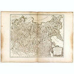
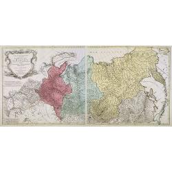
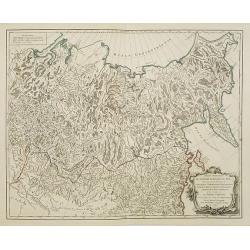
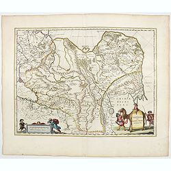
Partie Orientale de l'Empire de Russie en Asie.. et les Confins de la Tatarie Chinoise. . .
Large map with mostly topographical detail of mountains, deserts, rivers and forests. Covers the region from Tomsk eastward and includes Sakhal from his "Atlas Unive...
Place & Date: Paris, 1750
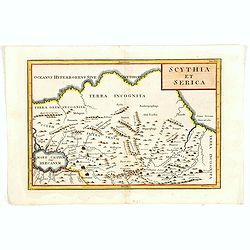
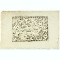
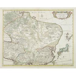
Scythia et Serica.
Covering the region between the Caspian and the Sea of China, much of which is Terra Incognita in the North and East. With title in upper right corner.Engraved by W.H.Tom...
Place & Date: London, 1755
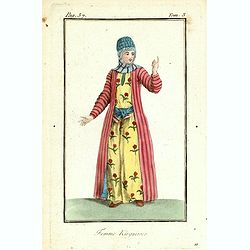
Femme de nord ets de l'Asie.
Originally hand-colored mezzotint of a woman from Nord West Asia engraved by Félix Mixelle and Lachaussée Jeune after Jacques Grasset de Saint-Sauveur.As an etcher, dra...
Place & Date: Paris,1801-1806
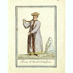
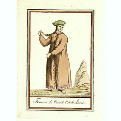
Femme du nord est de l'Asie.
Originally hand-colored mezzotint of a woman from Nord East Russia engraved by Félix Mixelle and Lachaussée Jeune after Jacques Grasset de Saint-Sauveur.As an etcher, d...
Place & Date: Paris,1801-1806
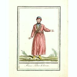
Femme Tattare de Kazan.
Originally hand-colored costume mezzotint of a Kazakhstan women engraved by Félix Mixelle and Lachaussée Jeune after Jacques Grasset de Saint-Sauveur.As an etcher, draw...
Place & Date: Paris,1801-1806
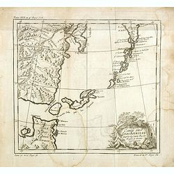
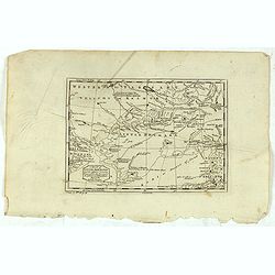
Carte des Isles Kouriles, d'après la carte Russe dréssée et gravée par Laurent.
An interesting map of the Kuril Islands, northeast from Hokkaido, Japan, to Kamchatka, Russia, separating the Sea of Okhotsk from the North Pacific Ocean.Prepared by Jacq...
Place & Date: Paris, 1738-1775
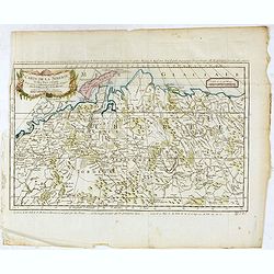
Carte de la sibérie et des Pays voisins.
An interesting detailed map of Siberia, extending from the White Sea and the Caspian Sea in the west to Irkuckoi Province .Prepared by Jacques Nicolas Bellin after Dutch ...
Place & Date: Paris, 1738-1775

Impery sino Tartarici Supremus Monarcha.
Decorative costume plate showing Kam Hi son of the Shunzhi Emperor of China [1638 - 1661?], the second emperor of the Manchu Qing dynasty, who apparently supported the fo...
Place & Date: Amsterdam, 1668
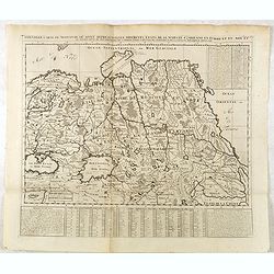
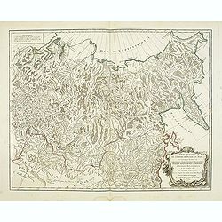
Carte géographique contenant le royaume de Sibérie . . .
Scarce and highly detailed map of Siberia subdivided into three provinces, namely Tobolsk, Jenissejesk, Irkutsk, and outer parts of the Tartary.In upper right corner inse...
Place & Date: Augsburg, c. 1770-1780
Carte de La Tartarie Orientale..
Uncommon edition of this fine map of Tartary with the Island of Sakhalin. In lower right engraved 21b.From Atlas Portatif pour servir a l'intelligence de l'Histoire Philo...
Place & Date: Amsterdam, 1773
Nouvelle Carte de Moscovie où sont representés les differents etats de sa Maiesté Czarienne..
Map of Russia Tartary and part of China with key tables to the towns. Depicting the different states belonging to the Czar in Asia and Europe, showing the path of one of ...
- $200 / ≈ €187
Place & Date: Amsterdam, ca. 1732
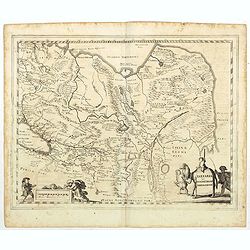
Carte de Tartarie.
Covering north east Asia, Tibet, Korea and part of "Terre d'Eso". Nova Zembla joined with the mainland.With good detail in Korea, several cities a labeled: Ch...
- $300 / ≈ €281
Place & Date: Paris, 1706
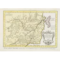
A Map of Western Tartary Drawn from the Survey of the Jesuits and Mr. Kyrillow's Map of the Russian Empire.
Uncommon map of the Gobi Desert and the eastern portion of the Silk Route region by Thomas Kitchin. Covers from Lake Baikal in the north as far south as Beijing, east to ...
- $110 / ≈ €103
Place & Date: London, 1745-1747
Partie Orientale de l'Empire de Russie en Asie.
Detailed map of the north-eastern part of Russia, including Siberia.
- $400 / ≈ €374
Place & Date: Paris 1752
A Map of Little Bochara, and the Adjacent Countrys Drawn from the Survey of the Jesuits and Mr. Kyrillows Map of the Russian Empire.
An uncommon map of the Gobi Desert and Bochara region. Engraved by Thomas Kitchin - with his signature in the lower bottom.From Astley, Thomas, "A New General Collec...
- $110 / ≈ €103
Place & Date: London, 1745-1747
Tartaria sive Magnichami Imperiorum.
Stretching from the Caspian Sea in the west to the top of the island Korea . Decorated with finely engraved mountains and the Chinese wall.
- $175 / ≈ €164
Place & Date: Frankfurt, 1650
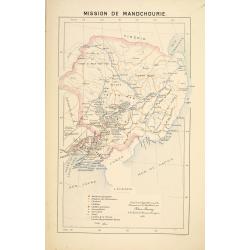
Mission de Mandchourie.
Important missionary map showing Manchuria in Russia and China, prepared by Adrien Launay, who was a French Missionary and later chronicler of the history of the French M...
- $100 / ≈ €94
Place & Date: Lille, 1890
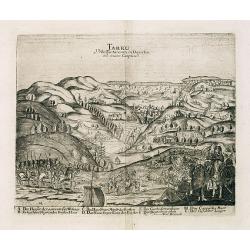
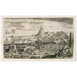
Tarku Urbs Tartaroum in Dagestan ad mare Caspium.
An early of Tarku, in the Republic of Dagestan. From the scarce Hamburg edition "Viel Vermehrte Moscowitische und Persianische Reisebeschreibung" by Adam Olear...
- $500 / ≈ €468
Place & Date: Hamburg, 1696
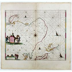
Noordoost Cust van Asia van Japan tot Nova Zemla.
An eye-catching chart of Hokkaido and the Islands to the North of Japan. Ships navigate the seas around the Siberian, Chinese and Japanese coasts extending as far west as...
- $2500 / ≈ €2339
Place & Date: Amsterdam, 1666
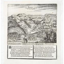
Tarku Urbs Tartaroum in Dagestan ad mare Caspium.
An early view of Tarku, in the Republic of Dagestan. From "Voyages en Moscovie, Tartarie et Perse, par Adam Olearius".Adam Olearius was a seventeenth-century G...
- $400 / ≈ €374
Place & Date: Paris, Abraham de Wicquefort , 1656
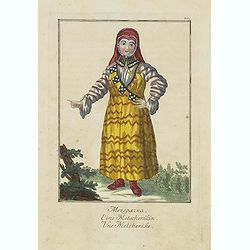
Une Metcherèke.
Uncommon copper engraved costume plate from the French translation of Johann Gottlieb Georgi "Beschreibung aller Nationen des russischen Reichs" (1776), the wor...
- $50 / ≈ €47
Place & Date: St. Petersbourg, C.G. Müller, 1776-1777
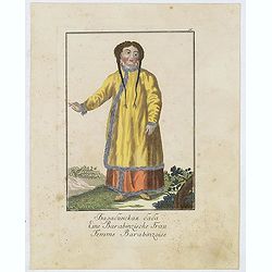
Une Baskirienne.
Uncommon copper engraved costume plate from the French translation of Johann Gottlieb Georgi "Beschreibung aller Nationen des Russischen Reichs" (1776), the wor...
- $50 / ≈ €47
Place & Date: St. Petersbourg, C.G. Müller, 1776-1777
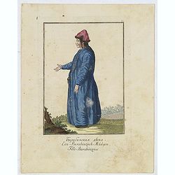
Fille Barabinzoise.
Uncommon copper engraved costume plate from the French translation of Johann Gottlieb Georgi "Beschreibung aller Nationen des Russischen Reichs" (1776), the wor...
- $50 / ≈ €47
Place & Date: St. Petersbourg, C.G. Müller, 1776-1777
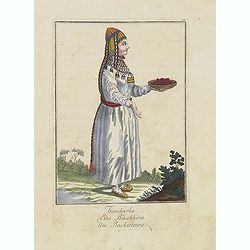
Femme Barabinzoise.
Uncommon copper engraved costume plate from the French translation of Johann Gottlieb Georgi "Beschreibung aller Nationen des Russischen Reichs" (1776), the wor...
- $50 / ≈ €47
Place & Date: St. Petersbourg, C.G. Müller, 1776-1777
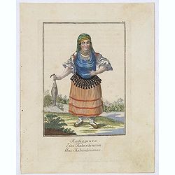
Une Kabardinienne.
Uncommon copper engraved costume plate from the French translation of Johann Gottlieb Georgi "Beschreibung aller Nationen des Russischen Reichs" (1776), the wor...
- $50 / ≈ €47
Place & Date: St. Petersbourg, C.G. Müller, 1776-1777
View of Derbendt an der Persischen Grentze.
An early view of Derbent, in the Republic of Dagestan. From "Voyages en Moscovie, Tartarie et Perse, par Adam Olearius".Adam Olearius was a seventeenth-century ...
- $400 / ≈ €374
Place & Date: Paris, Abraham de Wicquefort , 1656
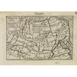
Tartaria.
A miniature map showing China, Korea and Russia. Title cartouche on the upper left corner.First published in 1598 in his Caert-Thresoor, the plates were executed by the m...
- $300 / ≈ €281
Place & Date: Amsterdam, 1609
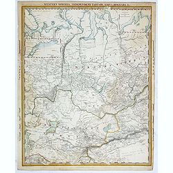
Western siberia, independent tartary, khiva, bokhara.....
This map was originally published by The Society for the Diffusion of Useful Knowledge in 1838, this date is printed on the map. This edition of the map was printed and p...
- $75 / ≈ €70
Place & Date: London, 1848
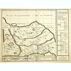
Grande Tartarie vers l'orient où sont le Turquestan, la Tartarie septentrionale, et la Tartarie du Kin. . .
Early edition of this rare map of Tartary which incorporates Turkestan (including East Turkestan), Greater Mongolia, Giacathai.The Great Wall is shown in the lower center...
- $750 / ≈ €702
Place & Date: Paris, 1677
Nieuwe kaart van Tartarie.
A map of Tartary, Korea and part of Japan. The map is most notable for the confusion between Kamchatka and Iesso. Hokaido labelled Compagnie LandFrom: Nieuwe en Beknopte ...
- $450 / ≈ €421
Place & Date: Amsterdam 1750
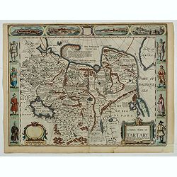
A newe mape of Tartary.
An early edition of one of the most decorative maps of Tartary, known for its figured borders with costume figures, while above are vignettes of the cities of Astrakhan, ...
- $2000 / ≈ €1871
Place & Date: London, 1676
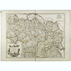
Partie Orientale de l'Empire de Russie en Asie.
Detailed map of the north-eastern part of Russia, including Siberia, Kamchatka, the island of Sakhalin.
- $200 / ≈ €187
Place & Date: Paris, 1752

Great or Asiatick Tartary, Agreable to Modern History.
Map of Tartary to Peking. The eastern coastline of Asia is almost flat, with no attempt to mark Kamchatka.
- $275 / ≈ €257
Place & Date: London, 1727
Tabula Tartariae et majoris partis regni Chinae.
Stretching from the Caspian Sea in the west to Formosa in the south-east. Including the peninsula of Korea, Japan and the east coast of Yedso. Decorated with finely engra...
- $800 / ≈ €749
Place & Date: Amsterdam, 1680
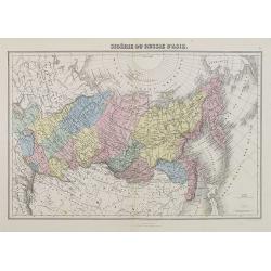
Sibérie ou Russie d'Asie.
A decorative map of Siberia from Géographie Universelle, Atlas Migeon. published by J. Migeon.From one of the last decorative atlases published in the 19th century.
- $50 / ≈ €47
Place & Date: Paris, 1874
Tartaria sive Magni Chami Imperium.
A detailed and decorative map of Tartary and the northern part of China. The very northern tip of Korea included. The Chinese Great Wall is depicted, with Central Asia, e...
- $500 / ≈ €468
Place & Date: Amsterdam, 1644
Femme Kirguisses.
Originally hand-colored mezzotint of Native Tartary lady engraved by Félix Mixelle and Lachaussée Jeune after Jacques Grasset de Saint-Sauveur. From 'Costumes civils ac...
- $25 / ≈ €23
Place & Date: Paris,1801-1806
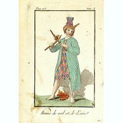
Homme du nord est de l'Asie.
Originally hand-colored mezzotint of a native from North Eastern Russia engraved by Félix Mixelle and Lachaussée Jeune after Jacques Grasset de Saint-Sauveur. From 'Cos...
- $50 / ≈ €47
Place & Date: Paris,1801-1806
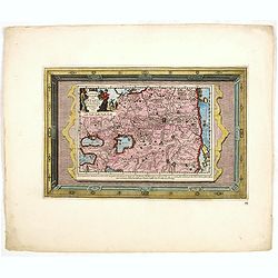
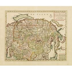
Naaukeurige Kaart Van Tartaryen . . .
This attractive map of Tartary is formed of two separate engravings, first is the map itself (23 x 16 cm) and second is the engraved framework border. Map detail extends ...
- $500 / ≈ €468
Place & Date: Amsterdam, 1713