Browse Listings in Asia > Tartary / Siberia
Tabula Tartariae et majoris partis regni Chinae.
Stretching from the Caspian Sea in the west to Formosa in the south-east. Including the peninsula of Korea, Japan and the east coast of Yedso. The Great Wall of China is ...
- $650 / ≈ €608
Place & Date: Amsterdam, 1680

Noordoost Cust van Asia van Japan tot Nova Zembla.
Important for its early depiction of Hokkaido and the Islands to the North of Japan. Ships navigate the seas around the Siberian, Chinese and Japanese coast extending as ...
- $3000 / ≈ €2807
Place & Date: Amsterdam, 1666

Carte des parties Nord et est de l'Asie.. (5 maps on one sheet)
Five maps on one sheet, showing California, Alaska and Syberia, Korea and Japan. South to Korea the island "Quelpaerts".The map is from Diderot's "Encyclop...
- $200 / ≈ €187
Place & Date: Paris, 1772
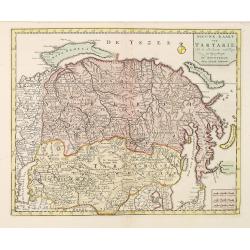
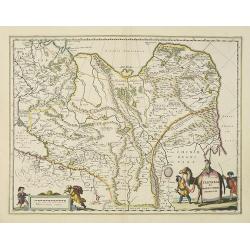
Nieuwe kaart van Tartarie.
A map of Tartary, Korea and part of Japan. The map is most notable for the confusion between Kamchatka and Iesso.Engraved by J.Keyser in 1731.
- $250 / ≈ €234
Place & Date: Amsterdam, 1731 / 1750
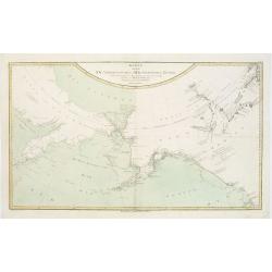
Karte von den N.W. Amerikanischen und N.OE. Asiatischen Kusten nach den Untersuchungen des Kapit. Cook...
A detailed large-scale map showing the Bering Strait, Kamchatka, Alaska and much of North America. While the Russian coastline is shown with reasonable accuracy. Showin...
- $450 / ≈ €421
Place & Date: Vienna, 1788
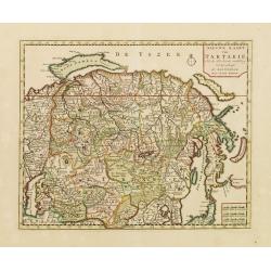
Nieuwe kaart van Tartarie.
A map of Tartary, Korea and part of Japan. The map is most notable for the confusion between Kamchatka and Iesso. Hokaido labelled Compagnie LandFrom: Nieuwe en Beknopte ...
- $450 / ≈ €421
Place & Date: Amsterdam 1750
Partie Orientale de l'Empire de Russie en Asie.
Detailed map of the north-eastern part of Russia, including Siberia.
- $400 / ≈ €374
Place & Date: Paris 1752

Noordoost Cust van Asia van Japan tot Nova Zemla.
An eye-catching chart of Japan, Hokkaido and the Islands to the North of Japan. In the lower left Korea and part of northern China. Korea has three names mentioned: "...
- $2000 / ≈ €1871
Place & Date: Amsterdam, 1666
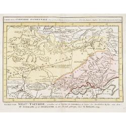
Carte de la Tartarie Occidentale.
Uncommon issue of this finely engraved map showing China's capital city of Peking inland from the Gulf of Lyau-tong. The map locates northeastern China to the border of R...
- $150 / ≈ €140
Place & Date: Amsterdam, 1749

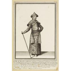
Impery sino Tartarici Supremus Monarcha.
Decorative costume plate showing Kam Hi son of the Shunzhi Emperor of China [1638 - 1661?], the second emperor of the Manchu Qing dynasty, who apparently supported the fo...
Place & Date: Amsterdam, 1668
Kam Hi Fils de Chien chi Empereur des Tartares orientaux?.plusieurs titres d'honneur Ecrits de sa propre main.
Very rare and decorative costume plate. Underneath the plate a descriptive text in French. Bears the address AParis Chez Nolin rue St. Jacques à l'Enseigne de la Place d...
- $300 / ≈ €281
Place & Date: Paris ca. 1690
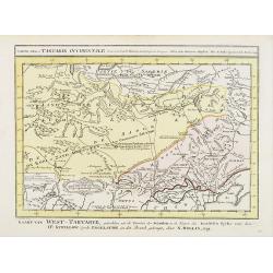
Carte de la Tartarie Occidentale.
Uncommon issue of this finely engraved map shows China's capital city of Peking, inland from the Gulf of Lyau-tong.The map locates in northeastern China to the border of ...
- $100 / ≈ €94
Place & Date: Amsterdam, 1749
Carte de La Tartarie Orientale..
Uncommon edition of this fine map of Tartary with the Island of Sakhalin. In lower right engraved 21b.From Atlas Portatif pour servir a l'intelligence de l'Histoire Philo...
Place & Date: Amsterdam, 1773
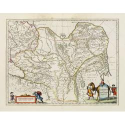
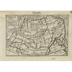
Tartaria sive Magni Chami imperium.
Detailed and decorative map of Tartary and Northern part of China, and the Chinese Great Wall is depicted. Including the Caspian Sea and the Volga River east as far as th...
- $575 / ≈ €538
Place & Date: Amsterdam, 1658
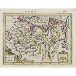
Tartaria.
Very fine and decorative engraving showing China, Korea and the northern Pacific coast of America.The two continents are separated by the Straits of Anian. From the first...
- $100 / ≈ €94
Place & Date: Amsterdam, 1608
Grande Tartarie et Isles du Japon Suivant les rélations les plus authentiques. . .
Attractive map of Russia, northern Asia, China, Tibet, Turkistan, and Japan, with decorative rococo-style cartouche.Flanked by two columns of French text containing geogr...
- $150 / ≈ €140
Place & Date: Paris, 1790

Carte des parties Nord et est de l'Asie..
Five maps on one sheet show the Northern Russian territories in Europe and Asia, including the western coastline from Siberia, Japan, and Korea with the island of "Q...
Place & Date: Paris, 1779
![[Fauna and flora - Siberia].](/uploads/cache/25815-250x250.jpg)
[Fauna and flora - Siberia].
Aquatint depicting a donkey, a weasel and a squirrel, and three botanical plants in Siberia engraved by C.A.Raineri, after drawings by C. Bottigella. Plate N° 22.From Gi...
- $50 / ≈ €47
Place & Date: Milan, 1827
![[Tartares Katschins ].](/uploads/cache/25818-250x250.jpg)
[Tartares Katschins ].
Aquatint depicting people from Tartary engraved by Cantelli, after drawings by C. Bottigella. Plate N° 26.From Giulio Ferrario's work Le Costume Ancien et Moderne ou His...
- $50 / ≈ €47
Place & Date: Milan, 1827
![[Ostiaks ].](/uploads/cache/25822-250x250.jpg)
[Ostiaks ].
Aquatint depicting a Ostiaks people engraved by D.K. Bonatti, after drawings by C. Bottigella.The Ostiak people are a tribe who inhabit the basin of the Ob in western Sib...
- $50 / ≈ €47
Place & Date: Milan, 1827
![[Samoyedes ].](/uploads/cache/25823-250x250.jpg)
[Samoyedes ].
Aquatint depicting Samoyedes warming up around a camp fire engraved by D.K. Bonatti, after drawings by C. Bottigella. The Samoyedes is a tribe of the Ural-Altaic group, s...
- $50 / ≈ €47
Place & Date: Milan, 1827
![[Yakuts ].](/uploads/cache/25825-250x250.jpg)
[Yakuts ].
Aquatint depicting Yakuts in traditional dress engraved by D.K. Bonatti, after drawings by C. Bottigella.The Yakuts live in the Republic of Sakha (YakutiaYakutia), Khabar...
- $75 / ≈ €70
Place & Date: Milan, 1827
![[Taoism religion of the Callmoucks].](/uploads/cache/25834-250x250.jpg)
[Taoism religion of the Callmoucks].
Aquatint depicting six Taoist deities engraved by D.K. Bonatti, after drawings by C. Bottigella. Plate N° 43. The Tatars people which live almost all in the north of Asi...
- $45 / ≈ €42
Place & Date: Milan, 1827
![[ Tartars ].](/uploads/cache/25836-250x250.jpg)
[ Tartars ].
Aquatint depicts a group of Tartars in traditional attire, engraved by D.K. Bonatti, after drawings by G.Gattina. Plate N° 45 From Giulio Ferrario's work Le Costume Anci...
- $45 / ≈ €42
Place & Date: Milan, 1827

La Tartaria Chinese.
With decorative title cartouche. Covering north eastern part of China, with good detail in Korea and a curious shape for Hokkaido (here called Jeso-Gasima ).Engraved by G...
Place & Date: Venice, 1784
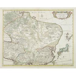
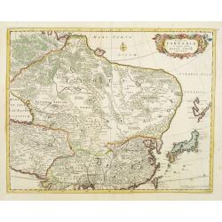
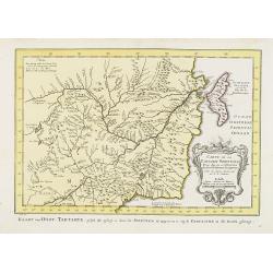
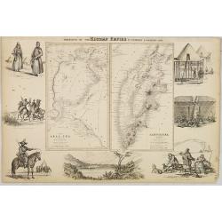
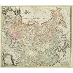
Tabula Tartariae et majoris partis regni Chinae.
Stretching from the Caspian Sea in the west to Formosa in the south-east. Including the peninsula of Korea, Japan and the east coast of Yedso. Decorated with finely engra...
- $800 / ≈ €749
Place & Date: Amsterdam, 1680
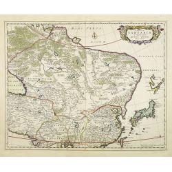
Tabula Tartariae et majoris partis regni Chinae.
Stretching from the Caspian Sea in the west to Formosa in the south-east. Including the peninsula of Korea, Japan, Taiwan and the east coast of Yedso. Decorated with fine...
- $900 / ≈ €842
Place & Date: Amsterdam, 1680
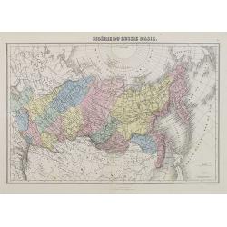
Sibérie ou Russie d'Asie.
A decorative map of Siberia from Géographie Universelle, Atlas Migeon. published by J. Migeon.From one of the last decorative atlases published in the 19th century.
- $50 / ≈ €47
Place & Date: Paris, 1874
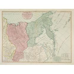
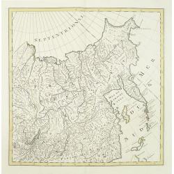
The Asiatic Part of the Russian Empire. . .
Large map of Asiatic Russia and some of the Aleutians recently discovered. Many details and speculations. Features the important discoveries of Vitus Behring (or Bering),...
- $500 / ≈ €468
Place & Date: London, 1794
Portions of the Russian Empire in eastern & western Asia.
Two maps on one sheet. Components: The Aral Sea according to Khanikoff -- Kamchatka according to A. Erman. Relief is shown by hachures and spot heights. No. 8 from Fullar...
- $200 / ≈ €187
Place & Date: London, 1860

A newe mape of Tartary.
Early edition of one of the most decorative "carte à figures"- map of Tartary, known for its figured borders with costume figures, while above are vignettes of...
Place & Date: London, 1627

La Tartaria Chinese.
With decorative title cartouche. Covering north eastern part of China, Korea and Hokkaido (here called Jeso-Gasima, Tartary including the Gobi Desert; also Peking and the...
Place & Date: Venice, 1784
Tartaria sive Magni Chami imperium.
Detailed and decorative map of Tartary and Northern part of China. Northern tip of Korea included. The Chinese Great Wall is depicted, with Central Asia, extending from M...
- $500 / ≈ €468
Place & Date: Amsterdam, 1638
Tartaria.
A miniature map showing China, Korea and Russia. Title cartouche on the upper left corner.First published in 1598 in his Caert-Thresoor, the plates were executed by the m...
- $300 / ≈ €281
Place & Date: Amsterdam, 1609
No title (Carte générale de l'empire de Russie).
The right hand sheet of a map of the Empire of Peter the Great.This important map is based on maps from the Bering expedition and on De L'Isle's Akademiia nauk Atlas of 1...
- $800 / ≈ €749
Place & Date: Amsterdam, ca.1748
Imperii Russici et Tartariae Universae tam majoris Afiaticæ quam minoris et EuropæTabula.
The map is of interest for the use of Mere Orientale Minus Corea for the sea between Korea and Japan.Decorative map covering Russia, Tibet, China, Tartary, Korea, Taiwan ...
Place & Date: Nuremberg, 1739
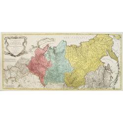
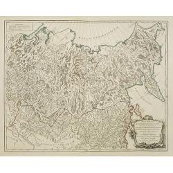
Carte géographique contenant le Royaume de Siberie . . .
Very rare and highly detailed map of Siberia subdivided in three provinces, namely Tobolsk, Jenissejesk, Irkutsk, and outer parts of the Tartary. In upper right corner in...
- $800 / ≈ €749
Place & Date: Augsburg, 1770- 1780
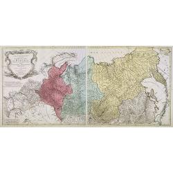
Carte géographique contenant le royaume de Sibérie . . .
Scarce and highly detailed map of Siberia subdivided into three provinces, namely Tobolsk, Jenissejesk, Irkutsk, and outer parts of the Tartary.In upper right corner inse...
Place & Date: Augsburg, c. 1770-1780
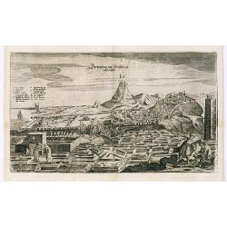
View of Derbendt an der Persischen Grentze.
An early view of Derbent, in the Republic of Dagestan. From "Voyages en Moscovie, Tartarie et Perse, par Adam Olearius".Adam Olearius was a seventeenth-century ...
- $400 / ≈ €374
Place & Date: Paris, Abraham de Wicquefort , 1656
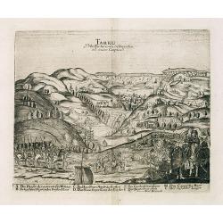
Tarku Urbs Tartaroum in Dagestan ad mare Caspium.
An early view of Tarku, in the Republic of Dagestan. From "Voyages en Moscovie, Tartarie et Perse, par Adam Olearius".Adam Olearius was a seventeenth-century G...
- $400 / ≈ €374
Place & Date: Paris, Abraham de Wicquefort , 1656