Browse Listings in Asia
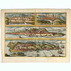
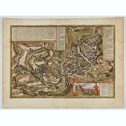
Casablanca (Anfa) - Azemmour (Azamor) - Diu - Old Goa (Velha Goa)
Four fine coastal views of these harbors cities which were important to Portuguese trade. Goa and Diu on the western coast of India, together with Anfa (Casablanc) and Az...
- $450 / ≈ €421
Place & Date: Cologne, 1618
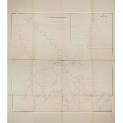
Plan de la rivierè de Saigon et de ses affluents dressé par ordre de M. le capitaine de vaisseau d'Ariès, gouverneur de Saigon, d'après les documents fournis par MM. Lespès. . .
A huge folded map the Saigon river prepared after Léo de Lespès, Rieunier Narac. Inset map of "Carte de Banc de Corail, levée d' après les ordres de Mr. le Capta...
- $750 / ≈ €702
Place & Date: St Joseph, Saigon, after 1860
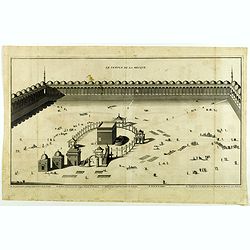
Le Temple de la Mecque.
Striking view of the Temple at Mecca, showing the Kaaba at the center of Islam's most sacred mosque, that is Al-Masjid Al-?aram, in Mecca, Hejaz, Saudi Arabia.The engravi...
- $1000 / ≈ €936
Place & Date: The Hague, Isaac Vaillant, 1721
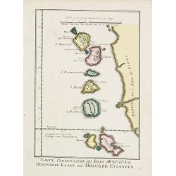
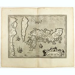
Carte Particuliere des Isles Moluques.
A very nice map centered on the island of the Moluccas.From Atlas Portatif pour servir a l'intelligence de l'Histoire Philosophique et Politique des etablissements et du ...
- $75 / ≈ €70
Place & Date: Amsterdam, 1773
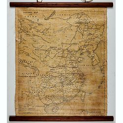
Railway map of China.
Railway map of China. Key in the left with keys to capital cities, Ocean cables, etc. Published by The Chinese Government Bureau of Economic Information, which was a nonp...
- $350 / ≈ €328
Place & Date: China, ca. 1928
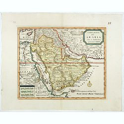
Carta nuova dell' Arabia fatta in Amsterdam per Isauc Tirion.
Detailed map of Arabia and environs, prepared by Albrizzi and published in Thomas Salmon in " Lo Stato Presente di Tutti i popoli del mondo naturale, politico e mora...
- $650 / ≈ €608
Place & Date: Napels, Francesco Ricciardo, 1738 -1762
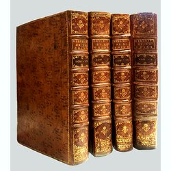
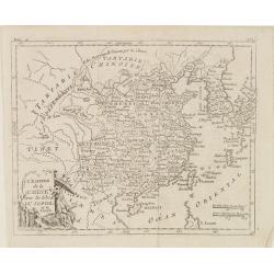
Description geographique, historique, chronologique, politique, et physique de l'empire de la Chine et de la Tartarie chinoise.
First edition of this cornerstone of any collection of books on China, which is also among the rarest and most desirable of important Americana, included in Rare American...
Place & Date: Paris, P. G. Le Mercier, 1735

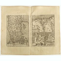
[Lot of 9 leaves with maps and views of Persia and Arabia).
Nineteen text leaves with wood block illustrations relating to Persia and Arabia. From the 1552 Latin text edition of Münster's Cosmographia, which is a short and comple...
- $100 / ≈ €94
Place & Date: Basel, 1552
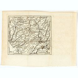
Mogol.
A very nice map of Northern India and Pakistan. From Francisco Giustiniani for El Atlas abreviado o el nuevo compendio de la Geografia universal, politica, historica, i c...
- $150 / ≈ €140
Place & Date: Leon de Francia (Lyon), Jaime Certa, 1739
![[7 Indian Patna water colors of crafts.]](/uploads/cache/43663-250x250.jpg)
[7 Indian Patna water colors of crafts.]
Seven Company school, also called Patna painting, style of miniature painting that developed in India in the second half of the 18th century in response to the tastes of ...
- $1500 / ≈ €1404
Place & Date: India, ca.1850
![[Lot of 8 leaves relating to the Holy Land]](/uploads/cache/48279-250x250.jpg)
[Lot of 8 leaves relating to the Holy Land]
Eight printed text leaves with maps and views relating to the Holy Land. From the 1552 Latin text edition of Münster's Cosmographia, which is a short and complete summar...
- $100 / ≈ €94
Place & Date: Basel, 1552
![[Lot of 6] Carte de la Baye d'Hocsieu. Fukin. (3 Maps + 3 Gravure of China)](/uploads/cache/IMG_2524-250x250.jpg)
[Lot of 6] Carte de la Baye d'Hocsieu. Fukin. (3 Maps + 3 Gravure of China)
[Lot of 6 items]. (3 Maps +3 gravure )- Carte de la Baye d'Hocsieu et des Entrees de la Riviere de Chang Situees dans la Province de Fokyen. J.N.Berlin 1748- Carte de l�...
Place & Date: Amsterdam, 1759
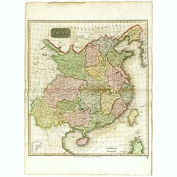
China.
Highly detailed map of China including Formosa (Taiwan), Hainan, and part of Luzon in the Philippines. The map show the Tract of the Hindoostan and Lion with the British ...
Place & Date: Edinburgh, 1815
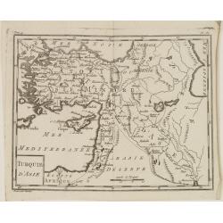
Turquie d'Asie.
Map of Turkey, including Cyprus and part of the Near East. From Atlas de la Géographie de toutes les parties du monde.. Ouvrage destiné pour l'education, et nécessaire...
Place & Date: Paris, Prudhomme, Levrault, Debray, 1806
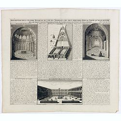
Description de la Celebre Mosquee de Com, Des Tombeaux Des Deux Derniers Rois de Perse qu'elle Renferme & du Grand Caravan-Serai De La Ville De Cachan Le Puls Magnifique de Tout L'Orient ...
Four views on one page with descriptive text showing the interior of the Mosquek, including the Sepulchre of Abas the Second and Sefy the First, along with the Tomb of th...
Place & Date: Amsterdam, 1720
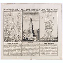
Description d'un des plus fameux temples des Chinois..
This impressive engraving is a wonderful example of Chatelain’s elegant plates.Divided in 3 panels, respectively showing the most important gods in the Chinese deities ...
Place & Date: Amsterdam, ca. 1720
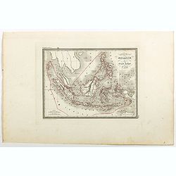
Carte de la Malaisie ou Grand archipel d'Asie.
Nice map of Indonesia, Philippines, Malacca with Singapore and tip of Northern Australia. Engraved by Thierry. Countries and regions in delicate out line color. Includes ...
Place & Date: Paris, 1835
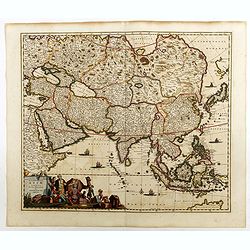
Accuratissima totius Asiae tabula..
The map includes a detailed depiction of South East Asia and the Far East. The northern tip of Australia (Hollandia Nova) is shown as are the important discoveries made t...
Place & Date: Amsterdam, 1680
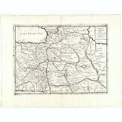
Armenia Vetus In Quatuor Partes..
Uncommon Italian version of a map of ancient Armenia prepared by Philip de la Rue. The map describes the four regions of Armenia, Greater Armenia, Second, Third and Fourt...
Place & Date: Padua, 1694
Archipel des indes Orientales
A finely engraved map depicting South East Asia with very good detail on the Philippines. Decorative title cartouche. From Atlas Universel of Gilles and Didier Robert de ...
Place & Date: Paris, 1750
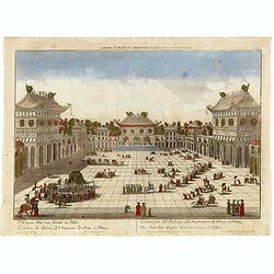
Le dedans du Palais de l'Empereur de Chine à Peking.
This so called optical print shows the imperial palace, the Forbidden City in Peking, China. In the foreground a large courtyard is depicted, surrounded by buildings. Thr...
Place & Date: Augsburg, 1760
Natoliae Quae Olim Asia Minor, Nova de Scriptio / Carthaginis Celeberrimi Sinus Typus / Aegypti re Centior de Scriptio
Three detailed regional maps by Ortelius from his "Theatrum Orbis Terrarum", the world's first modern atlas.The first map covers Asia Minor, Cyprus and the East...
Place & Date: Antwerp, 1598
Terra Sancta A Petro Laicstain perlustrata, et ab eius ore
Oriented to the east. Shows the shoreline from Beirut to Gaza. P. Laicksteen, a Dutch astronomer… collected topographic material on Palestine during his stay there in 1...
Place & Date: Antwerp, 1598
IAPONIAE INSULAE DESCRIPTIO.Ludoico Teisera auctore.
The map was based upon the manuscript draft supplied to Ortelius in about 1592 by the famous official Portuguese chart maker, Luis Teixeira , who was the cartographer t...
Place & Date: Antwerp, 1598
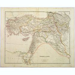
Turkey in Asia.
A lovely looking steel engraved map of Turkey in Asia. Map extent is Asia Minor, Syria, Holy Land, across to the Caucasian peoples that inhabit the lands between the Blac...
Place & Date: London, 1839
![[Sunda].](/uploads/cache/37956-250x250.jpg)
[Sunda].
Text engraving and coastal profiles in wood block from "Premier livre de l'histoire de la navigation aux Indes Orientales, par les hollandois, et des choses a eux ad...
Place & Date: Amsterdam, Cornille Nicolas, 1609
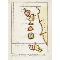
Carte Particuliere des Isles Moluques. . .
A very nice map centered on the island of the Moluccas.Title in French and in Dutch underneath the map.
Place & Date: Amsterdam, 1773
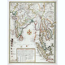
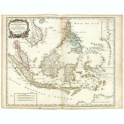
Les Indes Orientales sous le Nom de queles est compris L'Empire du Grand Mogol, Les Deux Presqu'Isles Deca et de la Le Gange, Les Maldives, et L'Isle de Ceylan . . . 1721
Rare map of the region including India, Malaysia with "Sincapur", Thailand, Sumatra, the eastern part of Java. The map is extended in the right border with Maca...
Place & Date: Paris, 1721

Carte de la Côte de Guzerat, Du Golf de Cambaye et des Côtes de Concan et De Canara.
French sea chart of West India from Gujarat to Mangalore. With inset chart Plan de la Rivière de Surate.Prepared by Jacques-François L'Abbé Dicquemare (1733-1789). La...
Place & Date: Paris, ca 1775
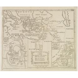
Carte des Régions et des Lieux dont il est parlé dans le Nouveau Testament.
Map of the eastern part of the Mediterranean with its hinterland. In the lower corners two inset maps: a plan of Jerusalem in the lower left, a map of Judea or Palestine ...
Place & Date: Paris, Prudhomme, Levrault, Debray, 1806
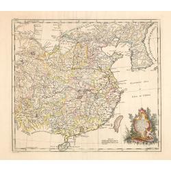
L'Empire de la Chine, avec les Isles du Japon, et la Corée.
Map of south eastern China, including Taiwan, Korea and Japan. From Atlas de la Géographie de toutes les parties du monde .. Ouvrage destiné pour l'education, et néces...
Place & Date: Paris, Prudhomme, Levrault, Debray, 1806
China as surveyed by the Jesuit Misionaries between the years 1708 & 1717 with Korea & the adjoining parts of Tartary.
The map is of interest for the use of Eastern Sea or Sea of China, the sea south of Korea. In the sea along the coast line of Korea : "Kau-Li-Qua or King:m of Korea&...
Place & Date: London, c. 1760
Selling price: $500
Sold in 2014
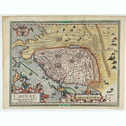
Chinae, olim Sinarum regionis. . .
The first printed map of China. It is signed by Ludovico Georgio, whose real name was Luis Jorge de Barbuda. He was a Portuguese Jesuit cartographer and besides that a sp...
Place & Date: Antwerp, 1598
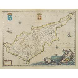
Cyprus Insulae.
Janssonius' beautiful map of Cyprus embellished with a very decorative title cartouche.
Place & Date: Amsterdam, 1640
Selling price: $1800
Sold in 2008
Hierosolymia, Clarissima totius Orientis civitas. . .
Two bird's eye perspectives on one sheet. The left plan shows ancient Jerusalem at the time of Christ. A contemporary view of Jerusalem appears to the right with an attra...
Place & Date: Cologne, 1582
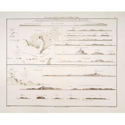
Küstenansichten von Japan bis Capstadt und St. Helena in 5 Blättern.
Prepared by Officer S.M.S. Arcona during the German expedition of 1860-1861 to South East Asia. Lithographed by Lippold and printed by C.Ulrich of Berlin. Sheet 2 from a ...
Place & Date: Berlin, 1863
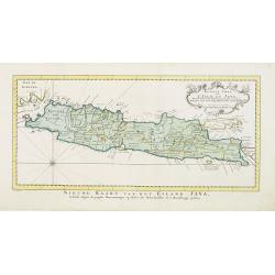
Nouvelle carte de l'Isle de Java.
A very nice map centered on the island of Java. With French text in title cartouche and an additional title in Dutch underneath the map.Read more Early maps of South East...
Place & Date: Amsterdam, 1773

Carte d'Asie divisée en ses principaux Etats.
Uncommon and decorative "carte à figures" wall map, prepared by Clouet, with superb decoration including a wonderful rococo border with vignettes describing hi...
Place & Date: Paris, Mondhare, 1787

Carte de l'Ile de Java. . .
An inset plan of Batavia and clearly indicated rice fields, mountains, forests, towns in profile, and even elephants, suggesting the wealth of detail found on this map. M...
Place & Date: Amsterdam, 1720
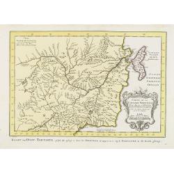
Carte de La Tartarie Orientale..
Uncommon edition of this fine map of Tartary with the Island of Sakhalin. In lower right engraved 21b.From Atlas Portatif pour servir a l'intelligence de l'Histoire Philo...
Place & Date: Amsterdam, 1773