Browse Listings in Asia > South East Asia > South East Asia general

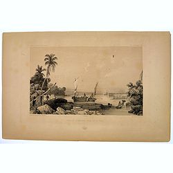
Eastern passage to China. sheet 1.
James Horsburgh early chart of the coasts of Java, Bali, Lombok, with part of Sulawesi, and Borneo. Insets of "Sketch of Bally Strait", Sketch of Lombock Strait...
- $2500 / ≈ €2339
Place & Date: London, 1824
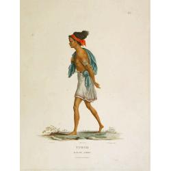
Timor - Malais libre.
A fine color plate from the rare travel book: Voyage de découvertes aux terres Australes . The Baudin voyage from 1800-1804 was the most successful French scientific exp...
- $100 / ≈ €94
Place & Date: Paris, Langlois, 1824
![Timor. Naba-Leba, Roi de L'Ile Solor. [plate XXV]](/uploads/cache/40114-250x250.jpg)
Timor. Naba-Leba, Roi de L'Ile Solor. [plate XXV]
Nicely colored portrait of the King of Solor, or Timor in South East Asia.After the original sketches by Lesueur, from Voyage de découvertes aux terres Australes by Fran...
- $100 / ≈ €94
Place & Date: Paris, 1824
![Timor. Naba-Leba Roi de L'Ile Solor. [plate XXV]](/uploads/cache/46347-250x250.jpg)
Timor. Naba-Leba Roi de L'Ile Solor. [plate XXV]
A portrait of a male Naba-Leba by Lesueur, from Voyage de découvertes aux terres Australes by François Péron, 1824.The French expedition under Nicolas Baudin, was comm...
- $250 / ≈ €234
Place & Date: Paris, 1824
![Timor. Canda Jeune fille Malaise. [plate XXVI]](/uploads/cache/46348-250x250.jpg)
Timor. Canda Jeune fille Malaise. [plate XXVI]
A portrait of a female Canda by Lesueur, from Voyage de découvertes aux terres Australes by François Péron, 1824.The French expedition under Nicolas Baudin, was commis...
- $250 / ≈ €234
Place & Date: Paris, 1824
![Timor. Rhinolophe Cruménifére. [plate XXXV]](/uploads/cache/46357-250x250.jpg)
Timor. Rhinolophe Cruménifére. [plate XXXV]
Plate illustrating Horseshoe bats from Timor Island, by Lesueur, from Voyage de découvertes aux terres Australes by François Péron, 1824.The French expedition under Ni...
- $150 / ≈ €140
Place & Date: Paris, 1824
![[ A man and woman from Timor ].](/uploads/cache/25847-250x250.jpg)
[ A man and woman from Timor ].
Aquatint depicting a man and woman from Timor, engraved by A.Biasioli. Plate N° 56. The weaving of traditional scarves or tais is widespread in East Timor. From Giulio...
- $50 / ≈ €47
Place & Date: Milan, 1827
![[Abiti degli isolani di Pogghy ].](/uploads/cache/34989-250x250.jpg)
[Abiti degli isolani di Pogghy ].
Aquatint depicting a couple of the island of Pogghy engraved by DK. Bonatti. Plate N°42.From Giulio Ferrario's work Le Costume Ancien et Moderne ou Histoire du gouvernem...
- $50 / ≈ €47
Place & Date: Milan, 1827
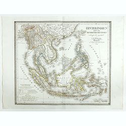
Hinter Indien nebst den Hinterindischen Inseln entwrfen und Gezeichnet von C.F. Weiland . . . 1828
Scarce map of Southeast Asia, including southern China, the Philippines, the Malaysian Peninsula and extending south to Java, Timor and the northern tip of Australia.The ...
- $300 / ≈ €281
Place & Date: Weimar, 1829
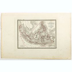
Carte de la Malaisie ou Grand archipel d'Asie.
Nice map of Indonesia, Philippines, Malacca with Singapore and tip of Northern Australia. Engraved by Thierry. Countries and regions in delicate out line color. Includes ...
Place & Date: Paris, 1835
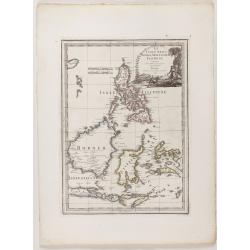
Le Insole della Sonda
Cassini’s splendid early map of Philippines, and Indonesia..Taken from the ""Nuovo Atlante Geografico Universale delineato sulle ultime osservazioni", pu...
Place & Date: Rome, Calcography, 1797-before 1839
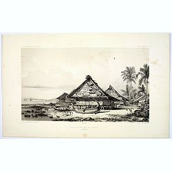
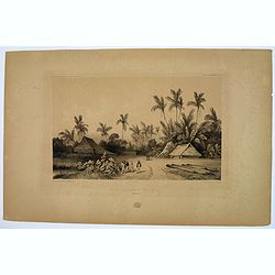
Village de Warrou.
Lithograph of the small settlement of Waru on the island of Seram in Indonesia. Plate 127, taken from the "Voyage au Pole Sud et dans L'Oceanie…." Departing i...
- $50 / ≈ €47
Place & Date: Paris, 1842
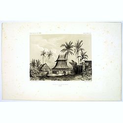
Mosquee du Village de Warou.
A lithograph of the mosque in the village of Waro, on the Indonesian island of Seram. Plate 128 taken from the 'Voyage au Pole et dans L'Oceanie…' Departing in late 183...
- $100 / ≈ €94
Place & Date: Paris, 1842
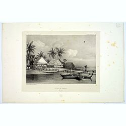
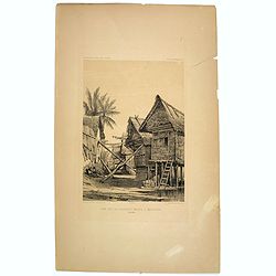
Rade et Village de Warrou.
An impressive lithograph of the dwellings to be found in the village of Waru, on the Indonesian island of Seram. Plate 126 taken from the 'Voyage au Pole et dans L'Oceani...
- $100 / ≈ €94
Place & Date: Paris, 1842
Une rue de Macassar.
A pretty lithograph of a street scene in the village of Makassar, on the southern edge of the Indonesian island of Sulawesi, formerly the Celebes Island. Plate 130 taken ...
- $30 / ≈ €28
Place & Date: Paris, 1842
Une rue du Quartier Malais a Macassar.
An attractive lithograph of the Malay living quarters in the southern village of Makassar in Sulawesi, formerly the Celebes island in Indonesia. Plate 131 taken from the ...
- $30 / ≈ €28
Place & Date: Paris, 1842
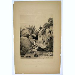
Aiguade d'Amboine.
Men with barrels in a river on the Indonesian island of Ambone. Plate112 taken from the 'Voyage au Pole et dans L'Oceanie…' Departing in late 1837 in the Astrolabe and ...
- $40 / ≈ €37
Place & Date: Paris, 1842
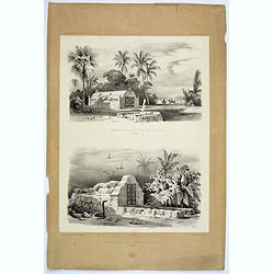
Tombeaux Malais pres de Coupang.
A lithograph displaying a pair of funeral monuments of both the Chinese and Malays, on the Indonesian island of Timor. Plate 192 taken from the 'Voyage au Pole et dans L'...
- $30 / ≈ €28
Place & Date: Paris, 1842
Ancien Etablissement Hollandais.
An ancient Dutch settlement in S.E. Asia. Plate123 taken from the 'Voyage au Pole et dans L'Oceanie…' Departing in late 1837 in the Astrolabe and Zélée, Dumont D'Urvi...
- $50 / ≈ €47
Place & Date: Paris, 1842
Aiguade d'Amboine pres de la Mer.
A lithograph of sailors unloading stores from a small sail boat in a tropical bay on the island of Amboina in Indonesia. Plate 112 taken from the 'Voyage au Pole et dans ...
- $50 / ≈ €47
Place & Date: Paris, 1842

Kaart van de Gaspar Straaten volgens opnemingen van J.Stolze, D.Ross, enz.
Very large and rare chart centered on the strait between Bangka's southeastern seacoast and Belitung's western shores.Short front views of the coastal relief are shown in...
- $900 / ≈ €842
Place & Date: Amsterdam 1843

Straat Riouw onder opzicht van de commissie tot verbetering der Indische Zeekaarten..
Very large and rare so-called Blue Back centered on the strait passing between the Riau Islands. It contains an inset map with enlarged details of Riouw Harbor on Bintang...
Place & Date: Amsterdam 1843
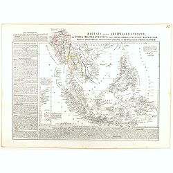
Malesia ossia Arcipelago Indiano, ed India-Transgangetica.
Attractive map of the Southeast Asia by a cartographer from Naples, listing his cartographic sources and giving political and statistical information on the areas covered...
- $500 / ≈ €468
Place & Date: Naples, 1848
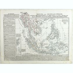
Malesia ossia Arcipelago Indiano, ed India-Transgangetica . . .
Attractive map of the Southeast Asia by a cartographer from Naples, listing his cartographic sources and giving political and statistical information on the areas covered...
- $450 / ≈ €421
Place & Date: Naples, 1848
Vicariato aplico di Bataviaa E prefettura di Labuan nella Oceania.
Map showing the boundaries of Catholic dioceses in Southeast Asia in 1850s, with some detail of Java, Borneo, Sumatra. Including the Philippines, but without detail. This...
- $1000 / ≈ €936
Place & Date: Rome, 1858-1859
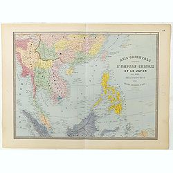
Carte de l'Asie orientale comprenant l'empire chinois le Japon les états de l'Indo-Chine et le grand archipel d'Asie ou Malaisie.
Detailed map of Malaysia, Thailand, China, Taiwan, and good detail in Philippines. Lower part of a 2-sheet map.
Place & Date: Paris, 1862

Carte générale de la mer des Indes dressée par P. Daussy et P.E. Wissocq, grave par Chassant, ecrit par J.M. Hacq.
Magnificent and detailed large-scale chartdepicting the Indian ocean, with east coast of Africa, Madagascar, Arabian Peninsula, India, China, etc .Including the West coa...
- $1000 / ≈ €936
Place & Date: Paris, 1837-1869
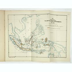
Papers relating to the affairs of Sulu and Borneo, and to the grant of a charter of incorporation of the British North Borneo Company. . . (with two folding maps of Indonesia)
58 pages Government recordings relating to the affairs of Sulu and Borneo, and to the grant of a charter of incorporation of the British North Borneo Company. . . (includ...
- $500 / ≈ €468
Place & Date: London, Harrison and son, 1882
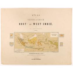
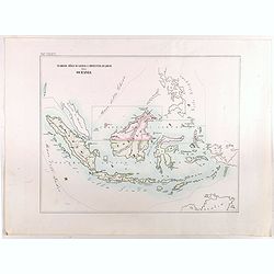
Overzichtskaart van den Nederlandsch oost Indischen Archipel.
Very detailed map of Indonesia, taken from "Atlas van Nederlandsch Oost- en West-Indie," prepared by a doctor I. Dornseiffen, and published by Seyffardt's Boekh...
Place & Date: Amsterdam, Seyffardt, 1884
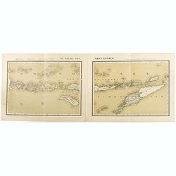
De kleine Soenda-Eilanden. Schaal van 1:800000.
Very detailed two sheet map of Soenda Islands, taken from "Atlas van Nederlandsch Oost- en West-Indie", prepared by doctor I. Dornseiffen, and published by publ...
- $30 / ≈ €28
Place & Date: Amsterdam, Seyffardt, 1884
![[Title page] Der Nederlandsche Bezittingen in Oost-Indië . . .](/uploads/cache/37336-250x250.jpg)
[Title page] Der Nederlandsche Bezittingen in Oost-Indië . . .
Decorative title page with in lower part a schematic map of Indonesia, and two hemispheres. Taken from "Atlas der Nederlandsche bezittingen in Oost-Indië", who...
- $75 / ≈ €70
Place & Date: The Hague, 1883-1885
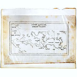
Hayter Basilisk, and Moresby Islands. (manuscript map)
An unusual small, and basic manuscript map of the Hayter Basilisk and Moresby Islands near Papua New Guinea, off the northern coast of Australia.
- $100 / ≈ €94
Place & Date: London, ca. 1890
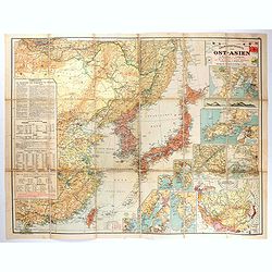
Übersichtskarte von Ost-Asien im Maßstabe 1: 5.000.000 mit 14 Beikarten in großen Maßstäben . . .
A large, uncommon map of East Asia prepared by Karl Peucker, and published by Ataria & Co. Striking and heavily annotated with information on China, Korea, Japan, and...
- $500 / ≈ €468
Place & Date: Vienna, Artaria, 1904
![Daily Telegraph War Map of The Far East. [No.11]](/uploads/cache/42244-250x250.jpg)
Daily Telegraph War Map of The Far East. [No.11]
A large and very detailed map of The Far East "Specially drawn for the Daily Telegraph by 'Geographia' Ltd". Printed in full color. Map extends from the norther...
- $125 / ≈ €117
Place & Date: London, ca. 1940

Ce que les Anglo-Saxons ont perdu en Extrême-Orient.
Illustrated Vichy propaganda War & Propaganda poster showing a map of South East Asia, with Indonesia, Philippines, Thailand, etc., among photos and explanations abou...
Place & Date: Paris, 1943

Indie moet vrij vecht ervoor.
War propaganda poster by Patrick (Pat) Cokayne Keely, distributed in the liberated South of the Netherlands, this poster concerned the Japanese occupation of Indonesia an...
Place & Date: London, J.Haworth / Brother Ltd, 1944

Du sang à l'aube.
Original lithographed poster for the Spanish movie "Blood at dawn" (1948) directed by Rafael Gil, based on the novel by Blasco Ibanez. Poster designed by Duccio...
Place & Date: Paris, 1948
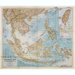
Southeast Asia Compiled and Drawn in the Cartographic Section of the National Geographic Society for the National Geographic Magazin Gilbert Grosvenor. . .
Map of the Southeast Asia, with inset map of Taiwan an map with Australia. The first issue of National Geographic Magazine was published on September 22, 1888, nine month...
Place & Date: Washington, 1952
Selling price: $50
Sold in 2018
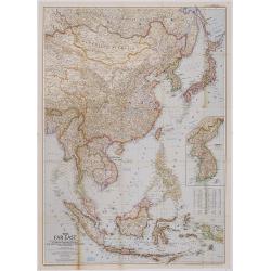
The Far East Compiled and Drawn in the Cartographic Section of the National Geographic Society for the National Geographic Magazine Gilbert Grosvenor. . .
Map of Far East Asia, with inset map of Korea. Scale 1:7.500.000. The first issue of National Geographic Magazine was published on September 22, 1888, nine months after t...
- $75 / ≈ €70
Place & Date: Washington, 1952

Indonesia.
Original vintage travel advertising issued by the Indonesian Council for Tourism featuring a colorful pictorial map marking the islands and oceans with images of local pe...
Place & Date: Jakarta, ca. 1955