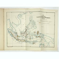
Browse Listings in Asia > South East Asia
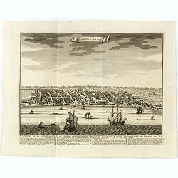
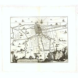
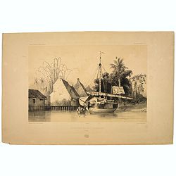
Samboepo in platte Grond.
Decorative panoramic view of the town of Samboupo on the island of Celebes (Sulawesi) in today's Indonesia. Dutch (V.O.C.) sailing ships and various local craft fill the ...
- $150 / ≈ €140
Place & Date: Amsterdam, 1726
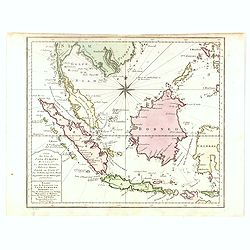
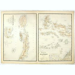
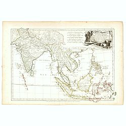
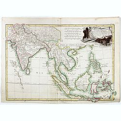
Carte des Isles de Java, Sumatra, Borneo. . . Malaca et Banca. . . / Kaart van de Eilanden van Java. . .
Dutch edition of this map of Indonesia prepared by N. Bellin and published by Pierre d'Hondt in Amsterdam. Jaques Nicolas Bellin (1703-1772) was one of the most important...
- $400 / ≈ €374
Place & Date: Amsterdam, 1747
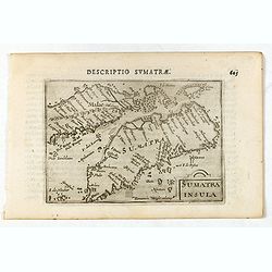
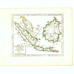
Sumatra Insula.
A miniature map of Sumatra containing detailed geography and nomenclature around the entire island. The neighbouring coast of the Malay Peninsula is shown, including Sing...
- $450 / ≈ €421
Place & Date: Amsterdam/Frankfurt 1609

Iava Maior.
Very fine miniature map of Java, engraved by Benjamin Wright (1575-1613). This early map contains detailed geography and nomenclature around the northern coastline of the...
Place & Date: Amsterdam, Cornelis Claes, 1606
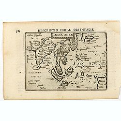
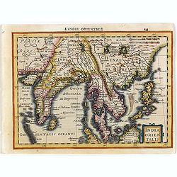
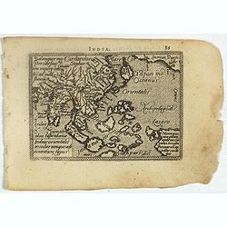
India Orien.
A miniature map showing India and the islands of Borneo, New Guinea, Sumatra, Java, etc.Korea as an enlonged peninsular and one town marked.First published in 1598 in his...
- $400 / ≈ €374
Place & Date: Amsterdam, Cornelis Claes, 1606
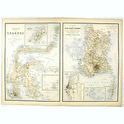
Kaart van Celebes / Kaart van Zuid-West-Celebes : bevattende de Gouvernem.ts, de leenroerige en een gedeelte der bondgenootschappelijke landen behoorende tot het Gouvernement van Celebes en onderh.
Very detailed map taken from "Atlas der Nederlandsche bezittingen in Oost-Indië", who was published by Departement van Koloniën".First edition of one of ...
- $50 / ≈ €47
Place & Date: The Hague, 1883-1885
Kaart van't noordwestelijke gedeelte der Residentie Amboina . . . / Kaart der Molukken.
Two very detailed maps on one sheet, taken from "Atlas der Nederlandsche bezittingen in Oost-Indië", who was published by Departement van Koloniën".The m...
- $75 / ≈ €70
Place & Date: The Hague, 1883-1885
![[Title page] Der Nederlandsche Bezittingen in Oost-Indië . . .](/uploads/cache/37336-250x250.jpg)
[Title page] Der Nederlandsche Bezittingen in Oost-Indië . . .
Decorative title page with in lower part a schematic map of Indonesia, and two hemispheres. Taken from "Atlas der Nederlandsche bezittingen in Oost-Indië", who...
- $75 / ≈ €70
Place & Date: The Hague, 1883-1885
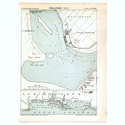
Tjilatjap (1888)
Detailed plan of the port and city of Tjilatjap on Java. Taken from "Atlas des Ports Etrangers". Lithographed by A. Simon.
- $25 / ≈ €23
Place & Date: Paris, 1888
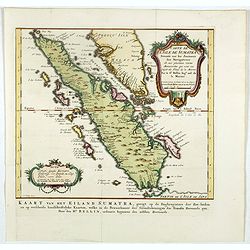
Carte de l'Isle de Sumatra. . . / Kaart van het Eiland Sumatra. . .
Map of Sumatra, also showing the tip of the Malay Peninsula and the Straits of Singapore. An unusually detailed map of the area, showing many coastal features, shoals, ba...
Place & Date: The Hague, Pierre d'Hondt, 1753
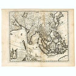
Les Indes Orientales suivant les nouvelles observations de Messrs. de l'Academie Royale des Sciences etc. augmentées de nouveau. . .
Fine and uncommon map of South East Asia, Japan, Korea, India and a the tip of Australia in lower right.Read more Early maps of South East Asia [+]
- $500 / ≈ €468
Place & Date: Leiden, 1719
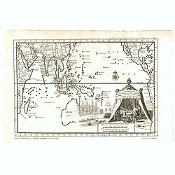
Indien onder den Heer Lopo Vaz De Sampayo, als Gouverneur Generaal tot aan Nieuw-Spanje in American on Kusten van Peru en Chili bevaaren.
Most decorative and scarce item, centred on Indonesia, including an incomplete coast of Australia, and west coast of America. The South Pacific is occupied by a large tit...
- $500 / ≈ €468
Place & Date: Leiden, 1707
D'Indize kusten van Bengale, Pegu, Malacca en Siam Tot in China. . .
Map of Indonesia, Malacca with Singapore (Cingapura) and Taiwan in upper right corner. In lower left a fine title cartouche showing Duarte de Menezes.Although not renowne...
- $450 / ≈ €421
Place & Date: Leiden, 1707
Waere affbeeldinge wegens het casteel ende stadt Batavia.
A good impression of Batavia's finely engraved and detailed plan, present-day Jakarta, the Dutch center of trading activities in the East Indies. Copied after Clement de ...
Place & Date: Leiden, 1719
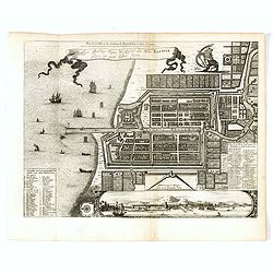
A Mapp of Batavia with all itts Forts.
Wonderful, scarce, and decorative plan of present-day Jakarta, showing the City and its immediate environs, the surrounding rice fields intersected by a network of waterw...
- $450 / ≈ €421
Place & Date: London, Printed for A. and J. Churchill, 1703
Les Indes Orientales et leur Archipel. . .
General map of Indonesia, extending from India to the Philippines and New Guinea.Ornated with a decorative title cartouche. Boundaries outlined in hand color.From theAtla...
- $250 / ≈ €234
Place & Date: Paris, ca 1783
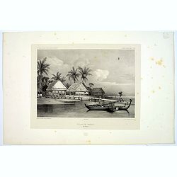
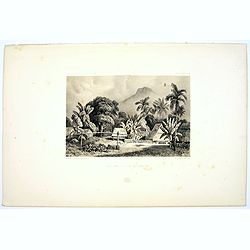
Village de Warrou.
Lithograph of the small settlement of Waru on the island of Seram in Indonesia. Plate 127, taken from the "Voyage au Pole Sud et dans L'Oceanie…." Departing i...
- $50 / ≈ €47
Place & Date: Paris, 1842
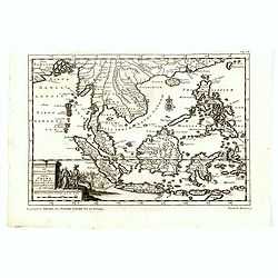
Les Isles de la Sonde Par le Sr. Robert de Vaugondy fils de Mr. Robert Geog. Ord du Roi avec Privilege 1749.
Small detailed map of of South East Asia, including Malaysian Peninsular with Singapore. From Atlas Portatif Universel, by Robert de Vaugondy.Page 170 outside border top...
- $200 / ≈ €187
Place & Date: Paris, 1749
Mosquee du Village de Warou.
A lithograph of the mosque in the village of Waro, on the Indonesian island of Seram. Plate 128 taken from the 'Voyage au Pole et dans L'Oceanie…' Departing in late 183...
- $100 / ≈ €94
Place & Date: Paris, 1842
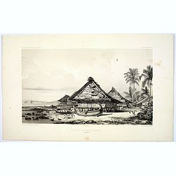
Rade et Village de Warrou.
An impressive lithograph of the dwellings to be found in the village of Waru, on the Indonesian island of Seram. Plate 126 taken from the 'Voyage au Pole et dans L'Oceani...
- $100 / ≈ €94
Place & Date: Paris, 1842
Site sur la Cote de Sumatra.
A lovely lithograph of a small settlement somewhere along the coast of Sumatra. Plate 154 taken from the 'Voyage au Pole et dans L'Oceanie…' Departing in late 1837 in t...
- $100 / ≈ €94
Place & Date: Paris, 1842
Rade d'Amboine.
A peaceful lithograph of ships and boats at anchor in Ambon Island, located in the archipelago of the Moluccas in Indonesia. Plate 108 taken from the 'Voyage au Pole et d...
- $35 / ≈ €33
Place & Date: Paris, 1842
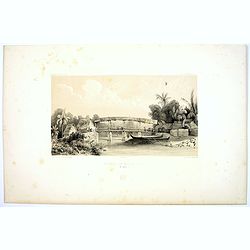
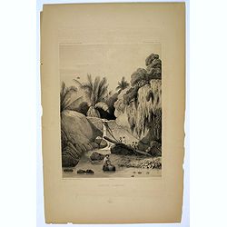
Riviere de Batou-Mera.
A lithograph of a simple bridge crossing the Batou-Mera river on the island of Ambone in the Moluccas, part of the Indonesian archipelago. Plate 110 taken from the 'Voyag...
- $100 / ≈ €94
Place & Date: Paris, 1842
Une rue de Macassar.
A pretty lithograph of a street scene in the village of Makassar, on the southern edge of the Indonesian island of Sulawesi, formerly the Celebes Island. Plate 130 taken ...
- $30 / ≈ €28
Place & Date: Paris, 1842
Une rue du Quartier Malais a Macassar.
An attractive lithograph of the Malay living quarters in the southern village of Makassar in Sulawesi, formerly the Celebes island in Indonesia. Plate 131 taken from the ...
- $30 / ≈ €28
Place & Date: Paris, 1842
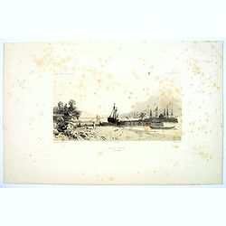
Rade de Ternate.
A peaceful harbour scene on the Moluccan island of Ternate in Eastern Indonesia. Plate 106 taken from the 'Voyage au Pole et dans L'Oceanie…' Departing in late 1837 in ...
- $50 / ≈ €47
Place & Date: Paris, 1842
Aiguade d'Amboine pres de la Mer.
A lithograph of sailors unloading stores from a small sail boat in a tropical bay on the island of Amboina in Indonesia. Plate 112 taken from the 'Voyage au Pole et dans ...
- $50 / ≈ €47
Place & Date: Paris, 1842
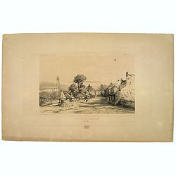
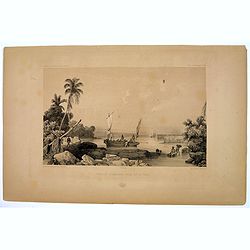
Entrée du Canal de Samarang.
A lovely lithograph of the canal entrance to the north eastern city of Semarang, on the Indonesian island of Java. Plate 147 taken from the 'Voyage au Pole et dans L'Ocea...
- $50 / ≈ €47
Place & Date: Paris, 1842
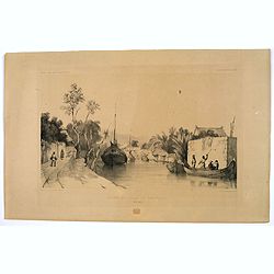
Canal de Samarang.
A tranquil lithograph showing a wealthy man being gently rowed up the canal in Semerang, on the Indonesian island of Java Plate 148 taken from the 'Voyage au Pole et dans...
- $50 / ≈ €47
Place & Date: Paris, 1842
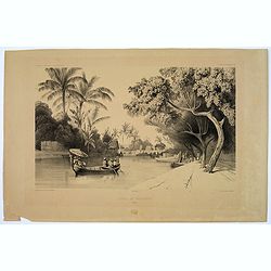
Site sur les bords du canal de Samarang.
A lithograph showing a Canalside scene of activity in the northeastern Javanese city of Semarang. Plate 149 taken from the 'Voyage au Pole et dans L'Oceanie…' Departing...
- $50 / ≈ €47
Place & Date: Paris, 1842
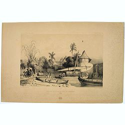
Quartier Malais a Samarang.
A fine lithograph depicting the Malay quarter in the north eastern Javanese city of Semarang in Indonesia. Plate 150 taken from the 'Voyage au Pole et dans L'Oceanie…' ...
- $75 / ≈ €70
Place & Date: Paris, 1842
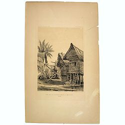
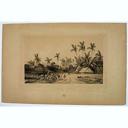
Case de Pecheurs dans la riviere Sambas.
A fishing hut seen along the Sambas River in Borneo. Plate 137 taken from the 'Voyage au Pole et dans L'Oceanie…' Departing in late 1837 in the Astrolabe and Zélée, D...
- $30 / ≈ €28
Place & Date: Paris, 1842
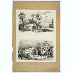
Tombeaux Malais pres de Coupang.
A lithograph displaying a pair of funeral monuments of both the Chinese and Malays, on the Indonesian island of Timor. Plate 192 taken from the 'Voyage au Pole et dans L'...
- $30 / ≈ €28
Place & Date: Paris, 1842
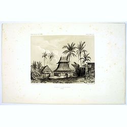
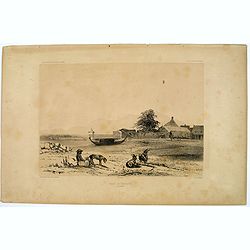
Ancien Etablissement Hollandais.
An ancient Dutch settlement in S.E. Asia. Plate123 taken from the 'Voyage au Pole et dans L'Oceanie…' Departing in late 1837 in the Astrolabe and Zélée, Dumont D'Urvi...
- $50 / ≈ €47
Place & Date: Paris, 1842
Aiguade d'Amboine.
Men with barrels in a river on the Indonesian island of Ambone. Plate112 taken from the 'Voyage au Pole et dans L'Oceanie…' Departing in late 1837 in the Astrolabe and ...
- $40 / ≈ €37
Place & Date: Paris, 1842
![[Java Fruits].](/uploads/cache/37933-250x250.jpg)
[Java Fruits].
Text engraving of fruits on Java from "Premier livre de l'histoire de la navigation aux Indes Orientales, par les hollandois, et des choses a eux advenues . . . &qu...
- $75 / ≈ €70
Place & Date: Amsterdam, Cornille Nicolas, 1609
![[Tropical fruits of Java].](/uploads/cache/37934-250x250.jpg)
[Tropical fruits of Java].
Two text engravings of fruits on Java from "Premier livre de l'histoire de la navigation aux Indes Orientales, par les hollandois, et des choses a eux advenues . . ....
- $75 / ≈ €70
Place & Date: Amsterdam, Cornille Nicolas, 1609
![[How the genteel folk of Bali are transported]](/uploads/cache/37935-250x250.jpg)
[How the genteel folk of Bali are transported]
Text engraving with explanation how the royalty and high-ranking citizens of Bali are transported about on light decorative chairs, with a shelter above to protect them f...
- $100 / ≈ €94
Place & Date: Amsterdam, Cornille Nicolas, 1609
![[View of the arrival of Cornelis de Houtman's fleet at Bantam, Java.].](/uploads/cache/37937-250x250.jpg)
[View of the arrival of Cornelis de Houtman's fleet at Bantam, Java.].
Engraved map of Bantam on Java with a lettered key (A-N) showing the arrival of Cornelis de Houtman’s fleet at Bantam, Java in 1596. Houtman’s four vessels, the Amste...
- $200 / ≈ €187
Place & Date: Amsterdam, Cornille Nicolas, 1609
![[Bantam]](/uploads/cache/37939-250x250.jpg)
[Bantam]
Two text engravings from "Premier livre de l'histoire de la navigation aux Indes Orientales, par les hollandois, et des choses a eux advenues . . . ", being the...
- $100 / ≈ €94
Place & Date: Amsterdam, Cornille Nicolas, 1609
![[Bantam].](/uploads/cache/37941-250x250.jpg)
[Bantam].
Text engraving showing the arrival of the Dutch fleet at Bantam from "Premier livre de l'histoire de la navigation aux Indes Orientales, par les hollandois, et des c...
- $150 / ≈ €140
Place & Date: Amsterdam, Cornille Nicolas, 1609
![[Foreign Merchants at Bantam].](/uploads/cache/37943-250x250.jpg)
[Foreign Merchants at Bantam].
Two text engravings from "Premier livre de l'histoire de la navigation aux Indes Orientales, par les hollandois, et des choses a eux advenues . . . ", being the...
- $100 / ≈ €94
Place & Date: Amsterdam, Cornille Nicolas, 1609
![[Javanese Vessels]](/uploads/cache/37947-250x250.jpg)
[Javanese Vessels]
Two text engravings from "Premier livre de l'histoire de la navigation aux Indes Orientales, par les hollandois, et des choses a eux advenues . . . ", being the...
- $100 / ≈ €94
Place & Date: Amsterdam, Cornille Nicolas, 1609
![[Dutch ship Amsterdam].](/uploads/cache/37948-250x250.jpg)
[Dutch ship Amsterdam].
Text engraving of the Dutch vessel Amsterdam offshore the island of Java near Surabaya from "Premier livre de l'histoire de la navigation aux Indes Orientales, par l...
- $150 / ≈ €140
Place & Date: Amsterdam, Cornille Nicolas, 1609
![[Celebrating the arrival of the Dutch in Turban].](/uploads/cache/37949-250x250.jpg)
[Celebrating the arrival of the Dutch in Turban].
Text engravings of a tournament in Turban. On 23rd January 1599, the Dutch landed at Turban (on the north coast of Java) with several small boats. Great crowds of people ...
- $150 / ≈ €140
Place & Date: Amsterdam, Cornille Nicolas, 1609
![[Plants and fruits of the East Indies].](/uploads/cache/37951-250x250.jpg)
[Plants and fruits of the East Indies].
Two text engravings from "Premier livre de l'histoire de la navigation aux Indes Orientales, par les hollandois, et des choses a eux advenues . . . ", being the...
- $50 / ≈ €47
Place & Date: Amsterdam, Cornille Nicolas, 1609
![[Ambon].](/uploads/cache/37953-250x250.jpg)
[Ambon].
Text engraving showing a bay on the Island of Ambon, an island in the Maluku Islands (Moluccas) of eastern Indonesia. Above the map a lettered key (A-D). Text engraving f...
- $150 / ≈ €140
Place & Date: Amsterdam, Cornille Nicolas, 1609
![[Ternate].](/uploads/cache/37954-250x250.jpg)
[Ternate].
Text engraving showing a bay on the Island of Ternate, an island in the Maluku Islands (Moluccas) of eastern Indonesia. Above the map a lettered key (A-E). Text engraving...
- $100 / ≈ €94
Place & Date: Amsterdam, Cornille Nicolas, 1609
![[Sumatra]](/uploads/cache/37955-250x250.jpg)
[Sumatra]
Text engraving from "Premier livre de l'histoire de la navigation aux Indes Orientales, par les hollandois, et des choses a eux advenues . . . ", being the clas...
- $50 / ≈ €47
Place & Date: Amsterdam, Cornille Nicolas, 1609
![[Sunda].](/uploads/cache/37956-250x250.jpg)
[Sunda].
Text engraving and coastal profiles in wood block from "Premier livre de l'histoire de la navigation aux Indes Orientales, par les hollandois, et des choses a eux ad...
Place & Date: Amsterdam, Cornille Nicolas, 1609
![Les Petit Voyages [Solor].](/uploads/cache/37958-250x250.jpg)
Les Petit Voyages [Solor].
This work by de Bry comprises probably the greatest single collection of material on early voyages to the East Indies, and are unique in their extraordinary wealth of car...
- $100 / ≈ €94
Place & Date: Frankfurt, 1601 - 1633
![[Javanese gamelan orchestra]](/uploads/cache/37960-250x250.jpg)
[Javanese gamelan orchestra]
Two text engravings from "Premier livre de l'histoire de la navigation aux Indes Orientales, par les hollandois, et des choses a eux advenues . . . ", being the...
- $75 / ≈ €70
Place & Date: Amsterdam, Cornille Nicolas, 1609
![[Bantam].](/uploads/cache/37963-250x250.jpg)
[Bantam].
Text engraving showing some merchants of Bantam, from "Premier livre de l'histoire de la navigation aux Indes Orientales, par les hollandois, et des choses a eux adv...
- $75 / ≈ €70
Place & Date: Amsterdam, Cornille Nicolas, 1609
![[Native Flora of Java].](/uploads/cache/37964-250x250.jpg)
[Native Flora of Java].
Text engraving of native flora of Java from "Premier livre de l'histoire de la navigation aux Indes Orientales, par les hollandois, et des choses a eux advenues . . ...
- $75 / ≈ €70
Place & Date: Amsterdam, Cornille Nicolas, 1609
![[Java].](/uploads/cache/37965-250x250.jpg)
[Java].
Wood block engraved coastal profiles set in text from "Premier livre de l'histoire de la navigation aux Indes Orientales, par les hollandois, et des choses a eux adv...
- $20 / ≈ €19
Place & Date: Amsterdam, Cornille Nicolas, 1609
![[Chinese Merchants and temple].](/uploads/cache/37966-250x250.jpg)
[Chinese Merchants and temple].
Two text engravings of Chinese merchants on Java and a Chines temple from "Premier livre de l'histoire de la navigation aux Indes Orientales, par les hollandois, et ...
- $100 / ≈ €94
Place & Date: Amsterdam, Cornille Nicolas, 1609
![[Bantam].](/uploads/cache/37970-250x250.jpg)
[Bantam].
Text engravings from "Premier livre de l'histoire de la navigation aux Indes Orientales, par les hollandois, et des choses a eux advenues . . . ", being the cla...
Place & Date: Amsterdam, Cornille Nicolas, 1609
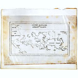
Hayter Basilisk, and Moresby Islands. (manuscript map)
An unusual small, and basic manuscript map of the Hayter Basilisk and Moresby Islands near Papua New Guinea, off the northern coast of Australia.
- $100 / ≈ €94
Place & Date: London, ca. 1890
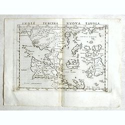
India Tercera Nuova Tavola.
Fine 1598 edition of this early map of South East Asia. Just to the west and south of Malacca, one will notice ‘Camatra’ (Sumatra) and Java. China with Canton in the ...
- $1000 / ≈ €936
Place & Date: Venice, 1598
Ware affbeeldinge wegens het casteel ende stadt Batavia. . .
A reduced version of Clement de Jonghe (1650) plan of Jakarta from 1650. The town plan has a vignette at the bottom showing Jakarta from the sea with the volcanoes Mount ...
- $800 / ≈ €749
Place & Date: Leiden, 1719

Insularum Moluccarum Nova description.
Exquisite map of the famous Spice Islands based on the islands described by Jan Huyghen van Linschoten. This map was the first large-scale map of the region and depicts t...
Place & Date: Amsterdam, 1730
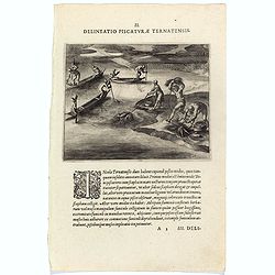
Delineatio Piscationum Ternatensis.
Fishing scene on Ternate island, Maluku, Indonesia.Theodore de Bry, a German engraver and book dealer, began a compilation of early voyages in 1590 and had published six ...
- $80 / ≈ €75
Place & Date: Frankfurt, 1609
Les Indes Orientales et leur Archipel. . .
General map of Indonesia, extending from India to the Philippines and New Guinea.Ornated with a decorative title cartouche. Boundaries outlined in hand color.From theAtla...
Place & Date: Paris, ca 1783
Selling price: $100
Sold in 2018

Carte des Indes, de la Chine & des Isles de Sumatra, Java &c..
This fine and quite detailed general map extends from northern Japan to Timor and from India to New Guinea.Here, the Terre de Yeco in northern Japan is still joined to th...
Place & Date: Amsterdam, 1720
Selling price: $450
Sold in 2018
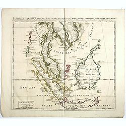
Le Royaume de Siam avec Les Royaumes Qui Luy sont Tributaries & c.
Influential map of Southeast Asia, including modern day Thailand, southern Vietnam, Cambodia, Malaysia, Singapore, Borneo, Sumatra and Java. Chatelain incorporated inform...
Place & Date: Amsterdam, c.1720
India Orientalis.
Map covering India, Thailand, Philippines, Northern Borneo and the coast of Southern China. From the rare Cloppenburg edition "Atlas Sive Cosmographicae Meditationes...
- $550 / ≈ €515
Place & Date: Amsterdam, 1630

Insulae Indiae Orientalis.
Map of South East Asia with good detail on the Philippines from the rare Cloppenburg edition slightly larger format and more scarce edition of the Mercator/Hondius "...
Place & Date: Amsterdam, 1630
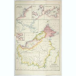
Borneo, shewing the lands ceded by the sultans of Brunei & Sulu to the British North Borneo Company.
Chromo lithographed folded map showing Borneo with Brunei, Sarawak, British North Borneo Company or Sabah. One of the first maps showing the British North Borneo Company ...
- $1750 / ≈ €1638
Place & Date: London, Stanford, 1881

India Tercera Nuova Tavola.
The 1598 edition of this early map of South East Asia. Just to the west and south of Malacca one will notice ‘Camatra’ (Sumatra) and Java. China with Canton in the up...
Place & Date: Venice, 1598
![Isole dell 'India cioè le Molucche le Filippine e della Sonda . . . [East Indies].](/uploads/cache/39593-250x250.jpg)
Isole dell 'India cioè le Molucche le Filippine e della Sonda . . . [East Indies].
In lower left hand corner a large title cartouche, decorated with mermaids, mermen and playful putti. A scarce, uncommon, late 17th century map of South East Asia, based ...
- $1800 / ≈ €1684
Place & Date: Rome, 1683
Indiae Orientalis, Insularumque Adiacentium Typus.
Map of Indonesia. From a French text edition of this illustrated treatise of geography, which is considered as the first modern pocket-atlas.Map engraved by Philip Galle....
- $500 / ≈ €468
Place & Date: Antwerp, 1585
Papers relating to the affairs of Sulu and Borneo, and to the grant of a charter of incorporation of the British North Borneo Company. . . (with two folding maps of Indonesia)
58 pages Government recordings relating to the affairs of Sulu and Borneo, and to the grant of a charter of incorporation of the British North Borneo Company. . . (includ...
- $500 / ≈ €468
Place & Date: London, Harrison and son, 1882
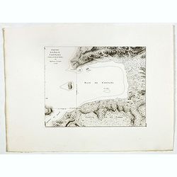
Esquisse de la Baie de Coupang (cote S.O. Ile de Timor) par M. M. Peron et Lesueur, an 1803.
Map of Kupang Bay on the Indonesian Island Timor, prepared by Louis Freycinet during his voyage under Captain Thomas Baudin in 1800-1803. Plate no. 14 from the atlas part...
- $150 / ≈ €140
Place & Date: Paris, Langois, 1811
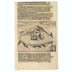
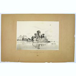
Solor.
Scarce print on German text sheet showing the Island of Solor. From "Petits Voyages". The island Solar, to the north of Timor, has a high mountain and has a ver...
- $100 / ≈ €94
Place & Date: Frankfurt, M.Merian, 1633
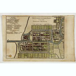
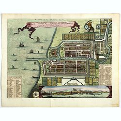
Grundriss von der Stadt und dem Schlosse Batavia.
Uncommon plan of the town and fortress of Batavia. The plan is based on the earlier, much larger map of Batavia published by Clement de Jonghe in 1650. From 'Algemeine We...
- $175 / ≈ €164
Place & Date: Halle, 1763-1792
![[The Dutch reach Annabon.]](/uploads/cache/40075-250x250.jpg)
[The Dutch reach Annabon.]
Eight days after leaving the mainland, the Dutch arrived at one of the Annabon islands (Pagalu), where they asked the Portuguese and Moors, who were occupying the island,...
- $100 / ≈ €94
Place & Date: Frankfurt, M.Merian, 1633
![[Borneo Insula.]](/uploads/cache/40082-250x250.jpg)
[Borneo Insula.]
Important map of Bornea based on a map by Olivier van Noort (1558-1627), who on his turn mostly adapted information from earlier maps such as those by Langenes and van Li...
- $300 / ≈ €281
Place & Date: Frankfurt, M.Merian, 1633
![Timor. Naba-Leba, Roi de L'Ile Solor. [plate XXV]](/uploads/cache/40114-250x250.jpg)
Timor. Naba-Leba, Roi de L'Ile Solor. [plate XXV]
Nicely colored portrait of the King of Solor, or Timor in South East Asia.After the original sketches by Lesueur, from Voyage de découvertes aux terres Australes by Fran...
- $100 / ≈ €94
Place & Date: Paris, 1824

Isole dell'Indie. . .
A beautiful and flamboyantly engraved large-scale map of the East Indies, including the Malay Peninsula, Cambodia, the Philippines and all of Indonesia and the Spice Isla...
Place & Date: Venice, 1696

Tabula nova utriusque Indiae.
This is the fourth and last edition of this map based on Waldseemüller's first "modern" map of Asia. It follows that cartography without change but adds an int...
Place & Date: Vienne, 1541