Browse Listings in Asia > South East Asia

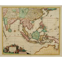
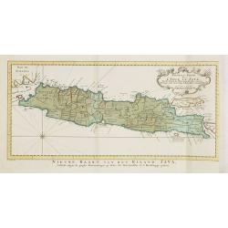
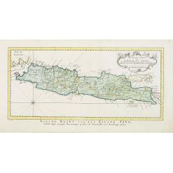
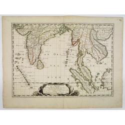
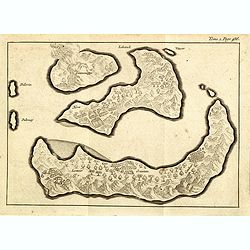
Carte de l'Ile de Java. . .
An inset plan of Batavia and clearly indicated rice fields, mountains, forests, towns in profile, and even elephants, suggesting the wealth of detail found on this map. M...
Place & Date: Amsterdam, 1720
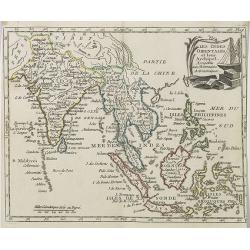
Indiae Orientalis nec non Insularum adiacentium.
Fine map of South East Asia from India to New Guinea with Japan and the southern tip of Korea in the upper right. The map leaves the question of Torres Straits unanswered...
- $1800 / ≈ €1684
Place & Date: Amsterdam, 1680
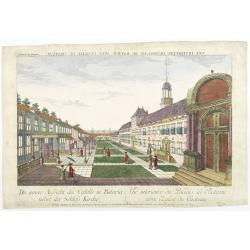
Die innere Aussicht des Castells in Batavia . . .
Showing the inside-square of the V.O.C. headquarters in Jakarta.The hand colored engraving is much perforated and the windows are cut out, a thin transparent paper is mou...
- $500 / ≈ €468
Place & Date: Augsburg, 1750
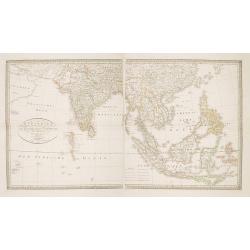
Charte von Ostindien Diesseits Und Jenseits Des Ganges / nach den neuesten astronomischen Beobachtungen auch andern sichern Hülfsmitteln neu entworfen. . .
Prepared by I.C.M.Reinecke giving good detail in India, Indonesia and the Philippines.
- $800 / ≈ €749
Place & Date: Weimar, 1822

Balinees watercolor on paper, fishermen.
Decorative export painting from Bali of a more than average quality.
- $150 / ≈ €140
Place & Date: Bali, ca 1960

Balinees watercolor on paper, fisherman.
Decorative export painting from Bali of a more than average quality.
- $150 / ≈ €140
Place & Date: Bali, ca 1960

Balinees watercolor on paper, fishermen.
Decorative export painting from Bali of a more than average quality.
- $150 / ≈ €140
Place & Date: Bali, ca 1960

Vue de L'Hotel de Batavie. . .
A so-called optical print of Fatahillah Square in Jakarta, Indonesia, prepared for use in a light-box or an amusing light-show. This richly hand colored print is much per...
Place & Date: Augsburg, 1750
Carte Des Isles de Java, Sumatra, Borneo.. Malaca et Banca..
Jacques Nicolas Bellin (1703-1772) was one of the most important and proficient French cartographers of the mid-eighteenth century. He was appointed the first Ingenieur H...
- $300 / ≈ €281
Place & Date: Paris, 1752

Belgium Foederatum auctius et emendatius edit..
Map of the northern part of the Netherlands. With a decorative title cartouche, with an inset map of South East Asia.
- $500 / ≈ €468
Place & Date: Augsburg, 1760
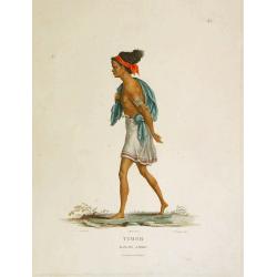
Timor - Malais libre.
A fine color plate from the rare travel book: Voyage de découvertes aux terres Australes . The Baudin voyage from 1800-1804 was the most successful French scientific exp...
- $100 / ≈ €94
Place & Date: Paris, Langlois, 1824
Nouvelle carte de l'Isle de Java.
A very nice map centred on the island of Java.With French text in title cartouche and an additional title in Dutch underneath the map.Read more Early maps of South East A...
Place & Date: Amsterdam, 1773
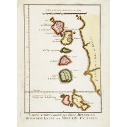
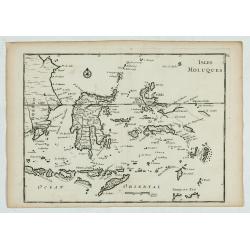
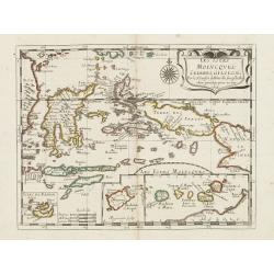
Carte Particuliere des Isles Moluques. . .
A very nice map centered on the island of the Moluccas.Title in French and in Dutch underneath the map.
Place & Date: Amsterdam, 1773

Carte générale de la mer des Indes dressée par P. Daussy et P.E. Wissocq, grave par Chassant, ecrit par J.M. Hacq.
Magnificent and detailed large-scale chartdepicting the Indian ocean, with east coast of Africa, Madagascar, Arabian Peninsula, India, China, etc .Including the West coa...
- $1000 / ≈ €936
Place & Date: Paris, 1837-1869
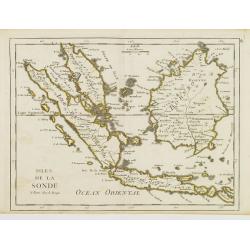
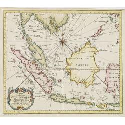
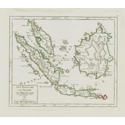
Isles de la Sonde.
Fine map of the islands of Java, Sumatra, Borneo, Bali and part of the Malay peninsular. George Louis Le Rouge was active from 1740- till 1780 as a publisher, and was app...
- $200 / ≈ €187
Place & Date: Paris, 1756
Isles Moluques.
A scarce little map depicting European knowledge of Sulawesi, part of Borneo and the Spice Islands at the time of publication.George Louis Le Rouge was active from 1740- ...
Place & Date: Paris, 1756
Selling price: $90
Sold in 2009

Kaart van een gedeelte van de Noord Kust van Java en Straat Sunda van Tanjong Kaik tot den vierden hoek bij Anjer..
Very large and rare chart depicting Java's northern seacoast.Coastal profiles are present at the bottom of the map.The chart is prepared by B.H.Staring, J.A.G.Rietveld an...
- $1500 / ≈ €1404
Place & Date: Amsterdam 1843-1844

Straat Sunda en Westkust van Java.
Very large and rare chart depicting Java's western seacoast close to the Sunda Strait.Showing part of Sumatra on top and the West Java tip, today hosting the Ujung Kulon ...
- $1500 / ≈ €1404
Place & Date: Amsterdam (1841)1846

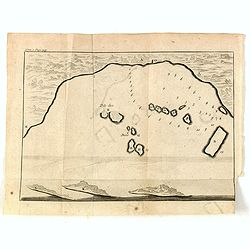
Kaart van de Gaspar Straaten volgens opnemingen van J.Stolze, D.Ross, enz.
Very large and rare chart centered on the strait between Bangka's southeastern seacoast and Belitung's western shores.Short front views of the coastal relief are shown in...
- $900 / ≈ €842
Place & Date: Amsterdam 1843

Kaart van de Reede van Batavia met de verschillende vaarwaters naar dezelve trigometrisch opgenomen op last van deb schout bijnacht E.Lucas.
Very large and rare so-called blue-black chart centered on Jakarta's harbor.The chart is prepared by B.G.Escher, I.A.C. Eschauzier, B.H.Staring and E.H.Boom during an exp...
- $2000 / ≈ €1871
Place & Date: Amsterdam (1841) 1847

Straat Riouw onder opzicht van de commissie tot verbetering der Indische Zeekaarten..
Very large and rare so-called Blue Back centered on the strait passing between the Riau Islands. It contains an inset map with enlarged details of Riouw Harbor on Bintang...
Place & Date: Amsterdam 1843
Banjowangui.
Early view of Banjowangui on the island of Java. Engraved in aquatint technique by Sigismond Himely (1801-1872) after Lauvergne. Published as plate 61 in Voyage autour du...
- $150 / ≈ €140
Place & Date: Paris, Finot, 1835
Rivière de Sourabaya.
Early view of Surabaya on the island of Java after Paris and engraved in aquatint technique by Sigismond Himely (1801-1872). Published as plate 61 in Voyage autour du mon...
- $300 / ≈ €281
Place & Date: Paris, Finot, 1835
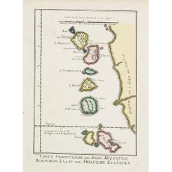
Carte Particuliere des Isles Moluques.
A very nice map centered on the island of the Moluccas.From Atlas Portatif pour servir a l'intelligence de l'Histoire Philosophique et Politique des etablissements et du ...
- $75 / ≈ €70
Place & Date: Amsterdam, 1773
Nouvelle carte de l'Isle de Java.
A very nice map centered on the island of Java. With French text in title cartouche and an additional title in Dutch underneath the map.Read more Early maps of South East...
Place & Date: Amsterdam, 1773
Les Isles de la Sonde.
Small detailed map of southeast Asia, showing the Malay Peninsula, Sumatra, Java and the island of Borneo. Dated 1769.From Atlas Portatif Universel, by Robert de Vaugondy...
- $200 / ≈ €187
Place & Date: Paris, later than 1769
Les Indes Orientales.. tirées du Neptune Oriental..
Finely and crisply engraved map centered on the Bay of Bengal, encompassing the Indian subcontinent and the Indochinese Peninsula.Venetian edition of Giles Didier Robert ...
- $450 / ≈ €421
Place & Date: Venice, 1779 - 1784
Les Iles Molvcques, Celebes, Gilolo. . .
Map of the Indian Ocean Islands of the Moluccas Islands prepared by N.Sanson and published by Pierre Mariette.Published in an early edition of the small Sanson atlas L'Eu...
Place & Date: Paris, P. Mariette, 1667
Selling price: $150
Sold in 2009

Sumatrae et insularum Locorumque nonnullorum circumiacentium. . .
Fine depicting the Island of Sumatra and the southern coasts of Malaysia from Quedo to Johore.North is orientated to the left of the page.Singapore is probably identifie...
Place & Date: Amsterdam, 1660
![[Sumatra plants ].](/uploads/cache/25837-250x250.jpg)
[Sumatra plants ].
Aquatint depicting coffee, pepper et other plants in Sumatra. Plate N° 46.From Giulio Ferrario's work Le Costume Ancien et Moderne ou Histoire du gouvernement, de la mil...
- $50 / ≈ €47
Place & Date: Milan, 1827
![[No title]. [Two locals of the island of Ubi ].](/uploads/cache/25845-250x250.jpg)
[No title]. [Two locals of the island of Ubi ].
Aquatint depicting two locals, one rowing to shore, the other searching for sea shells on the Island of Ubi in the Moluccas. Engraved by Carlo Bottigella. From Giulio Fer...
- $40 / ≈ €37
Place & Date: Milan, 1827
![[ Island of Bouro with a view of Cayeli ].](/uploads/cache/25846-250x250.jpg)
[ Island of Bouro with a view of Cayeli ].
Aquatint depicts a view of Cayeli on the island of Bouro. Engraved by G.Castellini. Plate N° 55.From Giulio Ferrario's work Le Costume Ancien et Moderne ou Histoire du g...
- $50 / ≈ €47
Place & Date: Milan, 1827
![[ A man and woman from Timor ].](/uploads/cache/25847-250x250.jpg)
[ A man and woman from Timor ].
Aquatint depicting a man and woman from Timor, engraved by A.Biasioli. Plate N° 56. The weaving of traditional scarves or tais is widespread in East Timor. From Giulio...
- $50 / ≈ €47
Place & Date: Milan, 1827
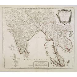
Partie Meridionale De L'Inde En deux Presqu'Isles l'une deca et l'autre Gange . . . 1654
Sanson's important mid-seventeenth-century map of India and Southeast Asia. At a scale of about 1:9,000,000, it covers most of modern India, Bangladesh and Burma, the who...
- $600 / ≈ €561
Place & Date: Paris, 1654
Les Indes Orientales et leur Archipel . . .
Map of India, the Maldive Islands, the Indonesian and Philippine Islands, from Atlas moderne portatif composé de vingt-huit cartes sur toutes les parties du globe terres...
- $300 / ≈ €281
Place & Date: Paris, Prudhomme, Levrault, Debray, 1806
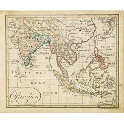
Ostindien.
Nice small map of South East Asia published by Johannes Walch in his rare Allgemeiner Atlas Nach den bewährsten Hülfsmitteln und astronomischen Ortsbestimungen…, edit...
- $160 / ≈ €150
Place & Date: Augsburg, 1812
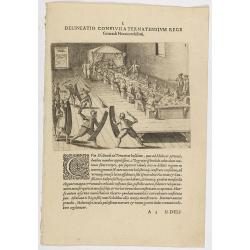
I. Delineatio convivii a Ternatensium rege Generali Neccio exhibiti.
This famous and desirable scene from Roelof Roelofsz's narrative of a voyage by J.C. van Neck to Ternate.Theodore de Bry, a German engraver and book dealer, began a compi...
- $100 / ≈ €94
Place & Date: Frankfurt, Wolfgangi Richteri, 1607
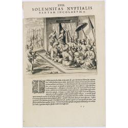
Solemnitas Nuptialis Bantam Incolarum. (A wedding ceremony in the city of Bantam)
When a young couple become engaged they do not leave their homes until the wedding takes place. On their wedding day they are dressed up and happy, and visited by all the...
- $75 / ≈ €70
Place & Date: Frankfurt, 1609
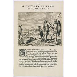
Milites in Bantam Gregarii Gum Suis armis. (Warriors of Bantam)
The warriors of Bantam carry both small and large shields made of leather, also swords or long lances with sturdy spear-heads. Their clothing is made with little square p...
- $75 / ≈ €70
Place & Date: Frankfurt, 1609
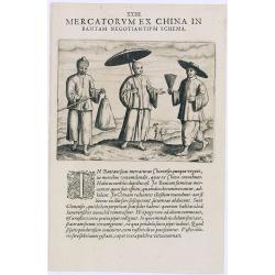
Mercatorum Ex China in Bantam Negotiantium Schema.
An early portrait of Chinese merchants in Banten (Bantam), a small port town near Java's western end.Theodore de Bry, a German engraver and book dealer, began a compilati...
- $100 / ≈ €94
Place & Date: Frankfurt, 1609
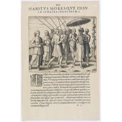
Habitus Moresque Insulae Sumatra Incolarum. (People of Sumatra)
People of Sumatra.Theodore de Bry, a German engraver and book dealer, began a compilation of early voyages in 1590 and had published six parts at the time of his death in...
- $100 / ≈ €94
Place & Date: Frankfurt, 1609
Delineatio Civitatis et Castelli Amboinae.
Early view of Ambon, with 6 Dutch vessels offshore.Theodore de Bry, a German engraver and book dealer, began a compilation of early voyages in 1590 and had published six ...
- $150 / ≈ €140
Place & Date: Frankfurt, 1609
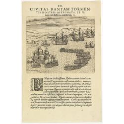
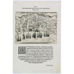
XVI. Civitas Bantam Tormentis nostris oppugnata . . .
Attack of Bantam (Banten), a city and former sultanate on Java island.Theodore de Bry, a German engraver and book dealer, began a compilation of early voyages in 1590 and...
- $100 / ≈ €94
Place & Date: Frankfurt, 1609
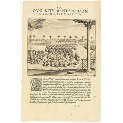
XXV. Quo Ritu Bantani Concilia Militaria Agant. 19. (Councils meeting at Bantam)
Councils meeting at Bantam (Banten), a city and former sultanate on Java island. Theodore de Bry, a German engraver and book dealer, began a compilation of early voyages ...
- $100 / ≈ €94
Place & Date: Frankfurt, 1609
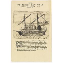
XXVII. Triremes seu Galiottae et Fustae Iavenenfium. 21. ( A typical Javanese man-of-war ship)
A typical Javanese man-of-war ship. The Javanese call their man-of-war ships, Cathurs. The slaves are all seated below deck and do the rowing with oars, while the warrior...
- $150 / ≈ €140
Place & Date: Frankfurt, 1609
View in the island of Cracatoa.
Early view of the volcano Krakatoa (Indonesian name: Krakatau), on the Indonesian island of Rakata in the Sunda Strait, taken from "Views in the South Seas" bei...
Place & Date: London, Boydell and Co., 1808

The Fan palm, in the island of Cracatoa.
The Fan palm, on the island of Krakatoa (Indonesian name: Krakatau), in the Sunda Strait, taken from "Views in the South Seas" being a very important and early ...
Place & Date: London, Boydell and Co., 1808

Eastern passage to China. sheet 1.
James Horsburgh early chart of the coasts of Java, Bali, Lombok, with part of Sulawesi, and Borneo. Insets of "Sketch of Bally Strait", Sketch of Lombock Strait...
- $2500 / ≈ €2339
Place & Date: London, 1824

Carte de l'Ile de Java.
An inset plan of Batavia and clearly indicated rice fields, mountains, forests, towns in profile and even elephants suggest the wealth of detail found on this map. Modele...
Place & Date: Amsterdam, 1720

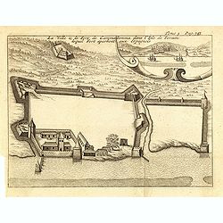
Vue et Description de Quelques-Uns des Principaux Forts des Hollandois dans les Indes .
Interesting sheet with seven detailed views illustrating the most important Dutch V.O.C. trading outposts and fortified colonial possessions in the East Indies, including...
Place & Date: Amsterdam, 1720
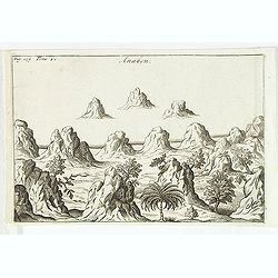
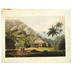
Anabon. (Ambon)
A fanciful view of a landscape on the island Ambon.From the French reissue of the account of early Dutch voyages first published in 1608 by Commelin. The French translati...
- $120 / ≈ €112
Place & Date: Amsterdam, E. Rogers, 1703
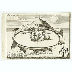
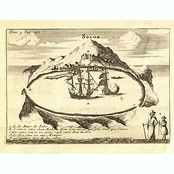
Solor / A la Baye de Solor.
Decorative map of the Bay of Solor. With a lettered key (A - E). Solor is a volcanic island located off the eastern tip of Flores island in the Lesser Sunda Islands of In...
- $120 / ≈ €112
Place & Date: Amsterdam, E. Rogers, 1703
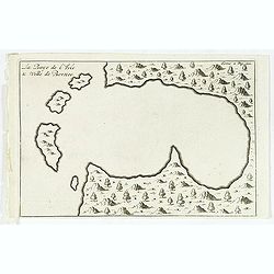
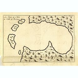
La Baye de l'Isle & ville de Borneo.
Uncommon map of a Bay on the island of Borneo. From the French reissue of the account of early Dutch voyages first published in 1608 by Commelin. The French translation w...
- $100 / ≈ €94
Place & Date: Amsterdam, E. Roger, 1703
![[Manuscript chart on vellum of the Java Sea]](/uploads/cache/33613-250x250.jpg)
[Manuscript chart on vellum of the Java Sea]
One of the few manuscript charts on vellum in private hands, signed by Isaac de Graaf. ORIGINAL MANUSCRIPT MAP IN RED, GREEN AND BLACK INK showing the Java Sea centered o...
Place & Date: Amsterdam, 1743
Insulae Sondae.
Rare small map of South East Asia, from "Kurtze bundige abbild und vorstellung der gantzen welt." by Johann Ulrich Muller. A second edition was published in Fra...
- $300 / ≈ €281
Place & Date: Ulm, 1692
Histoire universelle depuis le commmencement du monde jusqu'a present. Tome Vingt-unieme. Portugais, Espagnols, Hollanois etc
Volume 21 of this informative publication with a description of the discoveries, conquests, and settlements by the Portuguese, Spaniards, English, and Dutch in Southeast ...
- $1500 / ≈ €1404
Place & Date: Amsterdam, Leipzig, 1763
![[Abiti degli isolani di Pogghy ].](/uploads/cache/34989-250x250.jpg)
[Abiti degli isolani di Pogghy ].
Aquatint depicting a couple of the island of Pogghy engraved by DK. Bonatti. Plate N°42.From Giulio Ferrario's work Le Costume Ancien et Moderne ou Histoire du gouvernem...
- $50 / ≈ €47
Place & Date: Milan, 1827
Solor / A la Baye de Solor.
Decorative map of the Bay of Solor. With a lettered key (A - E). Solor is a volcanic island located off the eastern tip of Flores island in the Lesser Sunda Islands of In...
- $75 / ≈ €70
Place & Date: Amsterdam, F. Bernard, 1725
La Baye de l'Isle & ville de Borneo.
Uncommon map of a Bay on the island of Borneo. From the French reissue of the account of early Dutch voyages first published in 1608 by Commelin. The French translation w...
- $75 / ≈ €70
Place & Date: Amsterdam, F. Bernard, 1725
(Gunanappi / Wayer / Nera / Pulorin / Puloway .)
Uncommon map of islands in the Banda Sea. Several islands and villages are named, Wayer, Nera, Pulorin, Puloway, Lontoor, Ortattan and Combeer.From the French reissue of ...
- $75 / ≈ €70
Place & Date: Amsterdam, F. Bernard, 1725
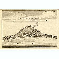
Ternate, par son aspect oriental.
This map is a view of Ternate with the summit of Gamalama from Dodoku Ali. From the French reissue of the account of early Dutch voyages first published in 1608 by Commel...
- $75 / ≈ €70
Place & Date: Amsterdam, J.F. Bernard, 1725
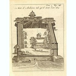
Le fort d'Amboine tel qu'il était en l'an 1607.
Fine plan of the Dutch fortress on Ambon Island which is part of the Maluku Islands of Indonesia. The island has an area of 775 km2 (299 sq mi).From the French reissue of...
- $75 / ≈ €70
Place & Date: Amsterdam, J.F. Bernard, 1725
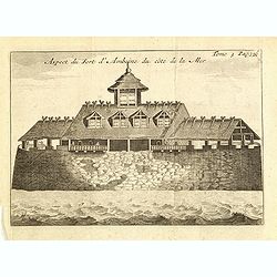
Le fort d'Amboine tel qu'il était en l'an 1607.
Fine depiction of the Dutch fortress on Ambon Island which is part of the Maluku Islands of Indonesia. The island has an area of 775 km2 (299 sq mi).From the French reiss...
- $80 / ≈ €75
Place & Date: Amsterdam, J.F. Bernard, 1725
La ville et le fort de Gamma-Lamma dans l'isle de Ternate lequel fort apartient aux Espagnols.
A view of the town and fortress on the island of Ternate. The city was in the southern part of the island, in the place now called Kastela. From the French reissue of the...
- $100 / ≈ €94
Place & Date: Amsterdam, J.F. Bernard, 1725

Allerneuester geographisch- und topographischer Schau-Platz von Africa und Ost-Indien. . .
An early issue of this important book by Johann Wolfgang Heydt's describing the Dutch factories, settlements and stations at the hands of the Dutch East India Company in ...
Place & Date: Wilhermsdorf, Tetscher u. Nürnberg, Homanns Erben, 1744
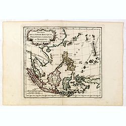
Les Isles de la Sonde, Moluques, Philippines, Carolines, et Marlannes.
Nice detailed map of southeast Asia, showing the Malay Peninsula, Sumatra, Java and the island of Borneo. Engraved by E. Dussy and the title cartouche by Arrivet. From hi...
- $275 / ≈ €257
Place & Date: Paris, ca. 1762
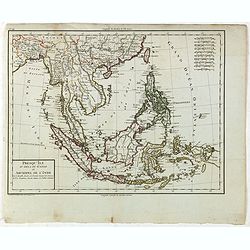
Presqu'Île au dela du Gange et Archipel de l'Inde.
Detailed map of Indonesia with Philippines and Taiwan. Engraved by P.F.Tardieu. From "Mentelle's Atlas Universe".
- $180 / ≈ €168
Place & Date: Paris, ca 1784 / 1806
(Bird's eye view of the Bay of Bantam)
Early view of the Bay of Bantam with the islands of Pulo dua and Batto.Bantam was always a product of the ferocious commercial rivalry between the Dutch and English and P...
- $75 / ≈ €70
Place & Date: Amsterdam, F. Bernard, 1725
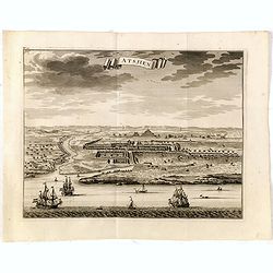
Astjien.
Nice bird's eye-view of the Town of Atjien on the northernmost point of Sumatra by François Valentijn (1666-1727), a missionary, who worked at Amboina from 1684 to 1694 ...
- $225 / ≈ €211
Place & Date: Amsterdam, 1726
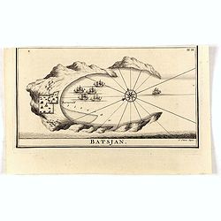
Batsjan. (Bacan)
Decorative panoramic view of Bay with the Dutch fortress Barneveld at the island of Bacan in today's Indonesia. Dutch (V.O.C.) sailing ships are illustrated.François Val...
- $45 / ≈ €42
Place & Date: Amsterdam, 1726
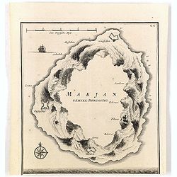
Makjan Geheel Bergagtig.
The island of Makian in Indonesia (formerly the Dutch East Indies) is represented on this map as a mountainous Möbius strip around a giant donut hole. François Valentij...
- $150 / ≈ €140
Place & Date: Amsterdam, 1726
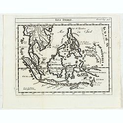
Les Indes.
Scarce small map of South East Asia with Indonesia, Thailand, Philippines and including New Guinee, based on cartography of Guillaume Delisle. Published in "Nouveau ...
- $125 / ≈ €117
Place & Date: Paris, La veuve Lottin & Butard, P.G. Le Mercier, Rollin, 1751

Nieuwe Kaart van het Eyland Sumatra..
Fine chart depicting the Island of Sumatra and the southern coasts of Malaysia from Quedo to Johore. North is orientated to the left of the page. Singapore is probably id...
Place & Date: Amsterdam, 1726
Esquisse de la Baie de Coupang (cote S.O. Ile de Timor) par M. M. Peron et Lesueur, an 1803.
Map of Kupang Bay on the Indonesian Island Timor, prepared by Louis Freycinet during his voyage under Captain Thomas Baudin in 1800-1803. Plate no. 14 from the atlas part...
- $100 / ≈ €94
Place & Date: Paris, Langois, 1811
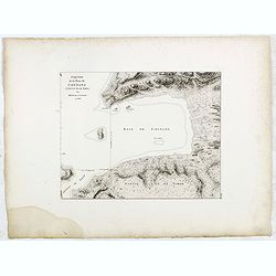
Kaart van de Zuyd-Wester Eylanden van Banda.
Map of the Banda islands.François Valentijn (1666-1727), a missionary, worked at Amboina from 1684 to 1694 and 1705 to 1713 and travelled extensively in the VOC's lands....
- $400 / ≈ €374
Place & Date: Amsterdam, 1726

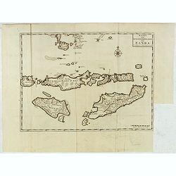
Nieuwe Caart der Eylanden van Banda.
Decorative map of the Banda Islands.François Valentijn (1666-1727), a missionary, worked at Amboina from 1684 to 1694 and 1705 to 1713 and travelled extensively in the V...
Place & Date: Amsterdam, 1726
![[Set of 4 maps] Indie Orientali di Quà e di la Dal Gange col Loro Arcipelago.](/uploads/cache/36680-250x250.jpg)
[Set of 4 maps] Indie Orientali di Quà e di la Dal Gange col Loro Arcipelago.
Fine almost wall sized map of South east Asia, including Formosa, New Guinea, the Maldives and the Indus delta. From his "Atlante Novissimo, illustrato ed accresciut...
- $850 / ≈ €795
Place & Date: Venice, ca. 1779 - 1785
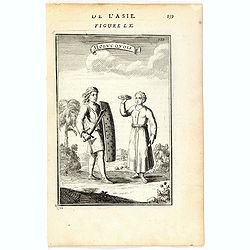
Molucquois (De L'Asie / figure LX).
A fine and uncommon early 17th century print of two people from Moluccas.From the French text edition of "Description d'Univers", 1683. by Allain Manneson Malle...
- $80 / ≈ €75
Place & Date: Paris, 1683
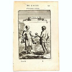
Habitants des Isles de la Sonde.
A fine and uncommon early 17th century print of two inhabitants of the Sunda Islands, East Indies (Indonesia).From the French text edition of Description d'Univers, 1683....
- $75 / ≈ €70
Place & Date: Paris, 1683
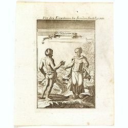
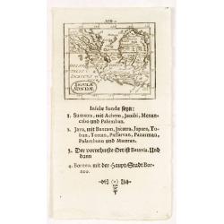
Von den Einwohnerne der Insulen Sonde (Fig LXIII).
A fine and uncommon early 17th century print of two inhabitants of the Sunda Islands, East Indies (Indonesia). Engraved by Joh. Jak. Vogel.By Allain Manneson Mallet (1630...
- $75 / ≈ €70
Place & Date: Frankfurt, 1684