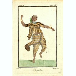
Bayadere.
Originally hand-colored mezzotint of a Temple Dancer engraved by Félix Mixelle and Lachaussée Jeune after Jacques Grasset de Saint-Sauveur.As an etcher, drawer and writ...
Place & Date: Paris,1801-1806
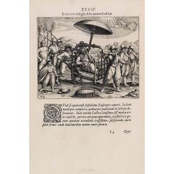
![[ LXXII. Divertimenti de' serpenti ].](/uploads/cache/34981-250x250.jpg)
[ LXXII. Divertimenti de' serpenti ].
Aquatint depicting snake charmers engraved by D.Klemi-Bonatti, Plate N°60.From Giulio Ferrario's work Le Costume Ancien et Moderne ou Histoire du gouvernement, de la mil...
- $50 / ≈ €47
Place & Date: Milan, 1827
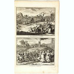
La procession de Ganga/ La fête de Huly.
Two scenes on one page showing religious scenes, in Japan. Fine copper engraving by Bernard Picart and taken from Bernard Picart's famous Céréonies et costumes religieu...
- $30 / ≈ €28
Place & Date: Amsterdam, 1743
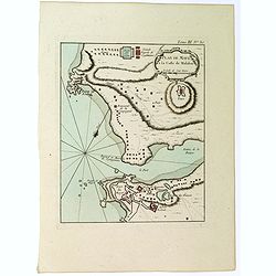
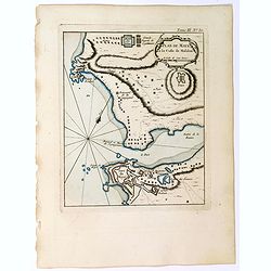
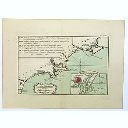
Plan de Maye a la Coste de Malabar.
From Bellin's 'Le Petit Atlas Maritime', a plan of the bay of Maye, off the Malabar coast of southern India. Relief shown pictorially. It shows settlements, ports, and ma...
- $85 / ≈ €80
Place & Date: Paris, 1764
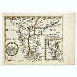
Malabar.
Small map illustrating the southwestern sea coast of India. Oriented with East on top, surrounded by text in Dutch.Included in the rare book : Wereld Spiegel, waer in ver...
- $200 / ≈ €187
Place & Date: Amsterdam, Cloppenburch, 1621
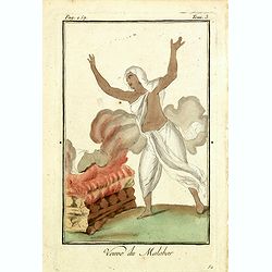
Venue du Malabar.
Originally hand-colored mezzotint of a widow of Malabar engraved by Félix Mixelle and Lachaussée Jeune after Jacques Grasset de Saint-Sauveur.As an etcher, drawer and w...
Place & Date: Paris,1801-1806
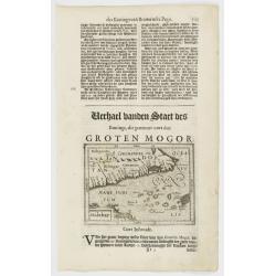
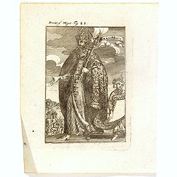
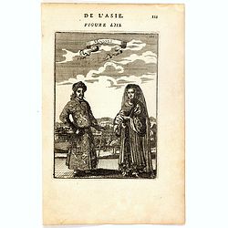
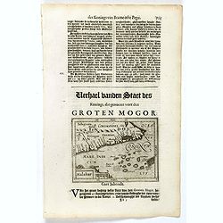
Der Grosse Mogol Fig LII.
A fine and uncommon early 17th century print of a Mogol.By Allain Manneson Mallet (1630-1706), a well traveled military engineer and geographer who worked in 17th century...
- $45 / ≈ €42
Place & Date: Frankfurt, 1684

Die Mogoler (Fig LIII).
A fine and uncommon early 17th century print of a couple at time of the Mughal Empire. Engraved by Joh. Jak. Vogel.By Allain Manneson Mallet (1630-1706), a well traveled ...
- $40 / ≈ €37
Place & Date: Frankfurt, 1684
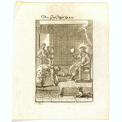
Grant Mogol - Der Graf Mogol (Fig LI).
A fine and uncommon early 17th century print of a Mughal emperor. Engraved by Joh. Jak. Vogel.By Allain Manneson Mallet (1630-1706), a well traveled military engineer and...
- $45 / ≈ €42
Place & Date: Frankfurt, 1684
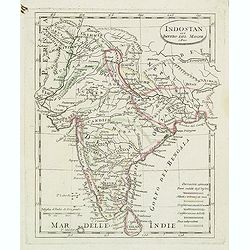
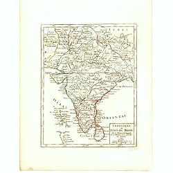
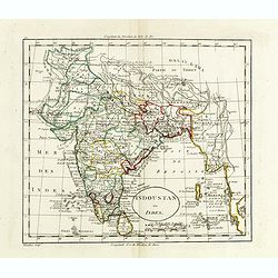
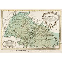
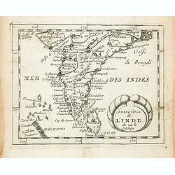
Indostan gia impero del mogol. . .
Charming map of India with Ceylon from the rare atlas Atlante Tascabile o sia Serie di Num. XXI Cartine Geografiche nelle quali si rappresenta in ristretto lo Stato Attua...
- $150 / ≈ €140
Place & Date: Rome, 1823
![[No title] Hindou](/uploads/cache/39730-250x250.jpg)
[No title] Hindou
Interesting sheet with four detailed engravings illustrating Hindou's life scenes. In upper right margin: 'Tom. V. No 42. Pag: 116.Henri Abraham Chatelain (1684 – 1743)...
- $100 / ≈ €94
Place & Date: Amsterdam, 1728
Indes. IIe. Feuille.
Attractive map of the southmost tip of India and Sri Lanka, including the Maldives and part of Sumatra. Boundaries are outlined in hand color.From the "Atlas moderne...
- $200 / ≈ €187
Place & Date: Paris ca 1783
Indoustan ou Etats du Mogol Par le Sr. Robert de Vaugondy fils de Mr. Robert Geog. Ord du Roi avec Privilege 1749.
Small detailed map of India with Ceylon. From Atlas Portatif Universel, by Robert de Vaugondy.Page 188 outside border top right. First and only state.
- $100 / ≈ €94
Place & Date: Paris, 1749
Carte De L'Indostan Servant à Indiquer Les Possessions Françaises En Asie.
Map of a part of Asia, with Sri Lanka, From " Nouvel Atlas du royaume de France, ou cartes détaillées des Gaules, de la France à l'époque de 1789, des 86 départ...
- $75 / ≈ €70
Place & Date: Paris, 1826
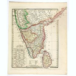
The Southern provinces of Hindoostan . . .
An attractive map showing Hindoostan and Ceylon. Shows towns, rivers, mountains, lakes, etc. In pretty original wash colors. Robert Wilkinson was active in London as a ca...
- $65 / ≈ €61
Place & Date: London, 1808
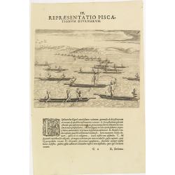
IX. Repraesentatio Piscationum Diurnarum.
Fishing offshore at the coasts of Guinea. Theodore de Bry, a German engraver and book dealer, began a compilation of early voyages in 1590 and had published six parts at ...
- $75 / ≈ €70
Place & Date: Frankfurt, 1609
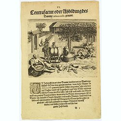
The extraordinary 'Abore Triste' tree of India.
In India there is an extraordinary tree, known as the 'Abore Triste', which is regarded as one of God's miracles. This tree flowers for a whole year but only at night tim...
- $80 / ≈ €75
Place & Date: Frankfurt, 1598
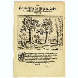
The trees that bear Cayus and Jambos and other plants.
Here are shown two trees that produce good fruits but it is the Jambos that is the best and most beautiful according to written accounts. Also shown is how the Perrer pla...
- $80 / ≈ €75
Place & Date: Frankfurt, 1598
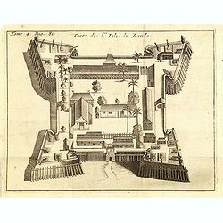
Fort de l'Isle de Banda.
Decorative print of the Dutch fortress on the island Banda.From the French reissue of the account of early Dutch voyages first published in 1608 by Commelin. The French t...
- $90 / ≈ €84
Place & Date: Amsterdam, F. Bernard, 1725
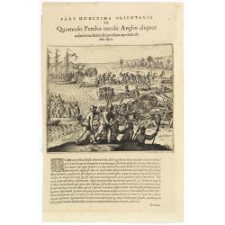
Pars Undecima Orientalis III. Quomodo Pembae incolae Anglos aliquot. . .
Finely engraved view of the arrival of Europeans at Pemba iIsland in Zanziba.Theodore de Bry, a German engraver and book dealer, began a compilation of early voyages in 1...
- $100 / ≈ €94
Place & Date: Frankfurt, 1609
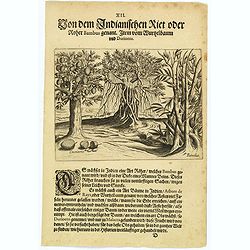
The bamboo, the tree of roots and the Durian fruit.
In India there is a kind of cane, known as Bambus, which has a stem as thick as a human leg. This is used for many things as it is light and yet strong. There is also a k...
- $80 / ≈ €75
Place & Date: Frankfurt, 1598
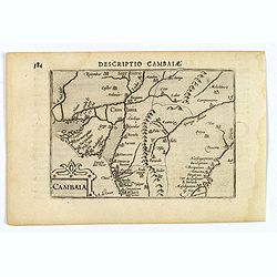
Descriptio Cambaiae.
A very decorative little map of northern India with Gujarat and the Indus river, bordering Pakistan. Naming major towns represented by symbols, major rivers, mountains, a...
- $100 / ≈ €94
Place & Date: Amsterdam, 1606
![[Mongolian pipe smoking ].](/uploads/cache/26258-250x250.jpg)
[Mongolian pipe smoking ].
Aquatint depicting a group of Mongolians in traditional attire during a pipe smoking ceremony. Chinese and Mongolian tradition had tobacco smoking from pipes with small m...
- $80 / ≈ €75
Place & Date: Milan, 1827
L'Inde deca et dela le Gange, ou est L'Empire du Grand Mogol. . .
An excellent mid 17th century map showing the area from Afghanistan and Pakistan in the west, and western China on the east, with most of India and extending north to the...
- $100 / ≈ €94
Place & Date: Paris, 1654
Mongols (De L'Asie / figure LIII).
A fine and uncommon early 17th century print of a Mogol couple.From the French text edition of "Description d'Univers", 1683. by Allain Manneson Mallet (1630-17...
- $80 / ≈ €75
Place & Date: Paris, 1683
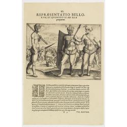
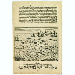
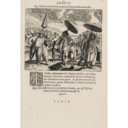
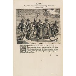
VI. Repraesentatio Bellorum, et Quomodo se ad Illa praeparent. (How the natives fight each other)
This shows how the men go to war and which weapons they use. They hold large square shields, about six feet high and four feet wide, made of cane and fortified with ox-hi...
- $90 / ≈ €84
Place & Date: Frankfurt, 1609
Quomodo Lusitanorum vxores & filiae deserrantur per publicum.
The way how the Portuguese carried a noble lady in India from Linschoten's famous voyages to the East of 1583-92 here published by De Bry the year after they first appear...
- $100 / ≈ €94
Place & Date: Frankfurt, 1599
Indoustan ou Inde.
Map of India. The map is based on the Paris Meridian, only in 1884, at the International Meridian Conference in Washington DC, the Greenwich Meridian was accepted.Engrave...
- $100 / ≈ €94
Place & Date: Paris, c. 1810
Plan de Maye a la Coste de Malabar.
From Bellin's "Le Petit Atlas Maritime", a plan of the bay of Maye, off the Malabar coast of southern India. Map relief shown pictorially. Shows settlements, po...
- $100 / ≈ €94
Place & Date: Paris, 1764
![Repraesentatio Aedificiorum in Benyn, et Quid Praeterea notatu dignum ibi occurrat. [Execution of criminals in Benin.]](/uploads/cache/29834-250x250.jpg)
Repraesentatio Aedificiorum in Benyn, et Quid Praeterea notatu dignum ibi occurrat. [Execution of criminals in Benin.]
Execution of criminals in Benin. According to the text: The town of Benin is quite large and comprises homes with no windows, only open roofs. The more distinguished hous...
- $100 / ≈ €94
Place & Date: Frankfurt, 1609
The bird called 'Eeme' and other creatures of India.
Especially on the island of Java and in India, is found a strange bird, called an 'Eeme'. It is almost as large as an ostrich with strong and sturdy legs but it has no to...
- $90 / ≈ €84
Place & Date: Frankfurt, 1598
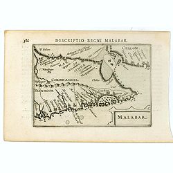
Malabar.
Small map illustrating the south western seacoast of India. Oriented with East on top, surrounded by text in Dutch.Nicolaes de Clerck (de Klerc) was active as engraver an...
- $175 / ≈ €164
Place & Date: Amsterdam, Cloppenburch, 1621
Carte de L'Indoustan. . .
Uncommon edition of this fine map of the northern part of India.From Atlas Portatif pour servir a l'intelligence de l'Histoire Philosophique et Politique des etablissemen...
- $150 / ≈ €140
Place & Date: Amsterdam, 1773
Coste de Coromandel depuis Gondagamas jusqu'a Narzapour.
This map is taken from Bellin'spopular 'Petit atlas maritime'. It shows a portion of the Indian coastline in the region of Coromandel from Montepdly through Mazulipatam o...
- $110 / ≈ €103
Place & Date: Paris, 1764
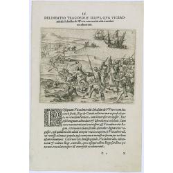
Delineatio Tragoediae Illius, Qua Viceadmiralis Sebaldus de Weert.
Event during Jan Harmensz Bree's account of the voyage to the East Indies in 1602-1604, under the command of Admirals Sebald De Weert and Pietersz to Ceylon, where de Wee...
- $150 / ≈ €140
Place & Date: Frankfurt, 1609
Malabar.
Very fine early miniature map of southern part of India and a part of Ceylon island. Title cartouche on the lower right corner.First published in 1598 in his Caert-Threso...
- $200 / ≈ €187
Place & Date: Amsterdam, Cornelis Claes, 1606
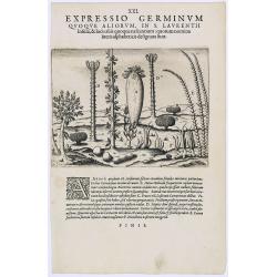
Expressio Germinum Quoque Aliorum, in S. Lavrentii.
Plants found in the island of S. Laurenti [Madagascar]. A’ denotes a tree with only a few twigs on the top. From this tree, canoes and boats are made. ‘B’ is a bush...
- $100 / ≈ €94
Place & Date: Frankfurt, 1609
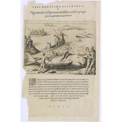
Pars Undecima Orientalis X. Quomodo in Septentrionalibus insulis prope. (How the inhabitants catch whales off the east coast of Madagascar.)
How the inhabitants catch whales off the east coast of Madagascar. When the natives of Santa Marta, off the east coast of Madagascar see a whale, they row out in their li...
- $100 / ≈ €94
Place & Date: Frankfurt, 1609
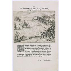
Delineatio Foederis Hollandorum cum Rege Calecutanorum pacti.
A treaty between the Dutch and the king of Calicut. The Dutch Admiral, Steffan van der Haagen already knew that the people of Calicut, on the Malabar Coast of India, were...
- $100 / ≈ €94
Place & Date: Frankfurt, 1609
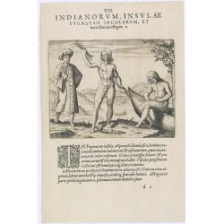
Indianorum, Insulae Pugnatan Incolarum. (The natives of the island of Pugnatan)
There was an island called Pugnatan at the western entrance to the Strait of Sudan, where the natives went about completely naked. Like the natives of Brazil, their hair ...
- $100 / ≈ €94
Place & Date: Frankfurt, 1609
Suite de la Carte des L'Indoustan, Iie Feuille..
Uncommon edition of this fine map of India.From Atlas Portatif pour servir a l'intelligence de l'Histoire Philosophique et Politique des etablissements et du commerce des...
- $200 / ≈ €187
Place & Date: Amsterdam, 1773
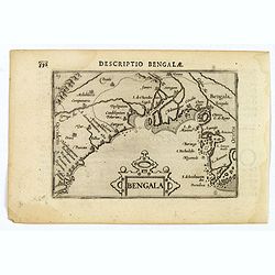
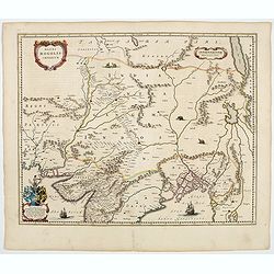
Bengala.
Small map centered on the Bay of Bengal, surrounded by text in Dutch. Nicolaes de Clerck (de Klerc) was active as engraver and publisher in Delft from 1599-1621.Included ...
- $150 / ≈ €140
Place & Date: Amsterdam, Cloppenburch, 1621
![East Indies. {India]](/uploads/cache/38623-250x250.jpg)
East Indies. {India]
Uncommon miniature map of India, engraved by Thomas Kitching for "A New General and Universal Atlas Containing Forty five Maps by Andrew Dury".This miniature at...
- $100 / ≈ €94
Place & Date: London, 1761-1763
Birds and fish seen during the voyage to India.
During their voyage to India many strange birds were seen, for example, the 'Garayos' that were the size of a chicken, the 'Rabos de Juncos' that are white and about the ...
- $100 / ≈ €94
Place & Date: Frankfurt, 1598
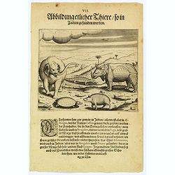
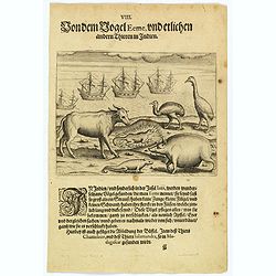
Some of the animals that are found in India.
Although most elephants are found in Ethiopia, there are also many in India too. They are called 'Caffres' by the inhabitants and are slaughtered for their tusks, which t...
- $100 / ≈ €94
Place & Date: Frankfurt, 1598
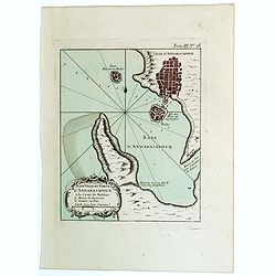
Baye Ville et Forts d'Andarajapour a la Coste de Malabar.
From Bellin's popular "La Petit Atlas Maritime", showing the bay, fort and town of Andarajapour in the Malabar region of India. The map is furnished with a comp...
- $110 / ≈ €103
Place & Date: Paris, 1764
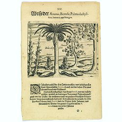
Pineapple, Bettel, palma dactylifera, Samaca & Mango.
These are all Indian fruits, of which the pineapple has the best flavour and aroma. The Bettel plant is also shown here climbing up long rods and canes, just as the peppe...
- $100 / ≈ €94
Place & Date: Frankfurt, 1598
Bengala.
A lovely miniature map of a section of the Bay of Begal, published by Petrus Bertius, in Amsterdam at the beginning of the seventeenth century. There is a decorative stra...
Place & Date: Amsterdam, 1606
Quo habitu vulgus Lusitanorum in India per publicum incedat. (Portuguese citizens and soldiers in Goa)
This famous and desirable scene is showing comportment and dress of the Portuguese citizens and soldiers in East India as they appear in the streets from 1599. From Part ...
- $150 / ≈ €140
Place & Date: Frankfurt, 1599
![[No title] Mongol.](/uploads/cache/39729-250x250.jpg)
[No title] Mongol.
Interesting sheet with four detailed engravings illustrating Mongol's life scenes. In upper right margin: 'Tom. V. No 43. Pag: 116.Henri Abraham Chatelain (1684 – 1743)...
- $150 / ≈ €140
Place & Date: Amsterdam, 1728
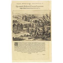
Pars Undecima Orientalis II. Quomodo Robertus, Caverta Capitaneus.
Fine engraving showing the arrest of the English captain Robert Caverta. Below an explanation in Latin that Caverta was arrested and killed by order of the king of the Co...
- $100 / ≈ €94
Place & Date: Frankfurt, 1609
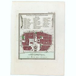
Plan de la ville de Pondicheri.
The first detailed French plan of Pondicherry. In the lower part, a lettered and numbered key and the coat of arms of Mr. Joseph-François Dupleix.The Compagnie des Indes...
- $120 / ≈ €112
Place & Date: Paris, 1800
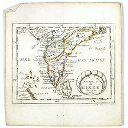
Presqu''isle de L'Inde de ça le Gange.
Uncommon miniature map of India from Pierre Duval's La Geographie Universeille dated 1676. Following his Cartes de geographie in 1657, Pierre Duval published this smaller...
- $120 / ≈ €112
Place & Date: Paris, 1676
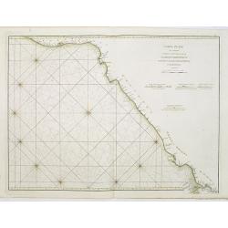
Carte Plate qui comprend La partie septentrionale de LA Cöte de Coromandel et les Côtes de Golconde , D' Orcha et de Bengale.
French chart of Coromandel in India. West to the top.Latitude and longitude scales, compass rose and system of rhumb lines, soundings near coast and in bay areas.D' Aprè...
- $150 / ≈ €140
Place & Date: Paris, Brest, chez Demonville, 1775
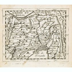
Empire du Mogol.
Uncommon miniature map of the Mongol empire from Pierre Duval's La Geographie Universeille dated 1676. Following his Cartes de geographie in 1657, Pierre Duval published ...
- $150 / ≈ €140
Place & Date: Paris, 1676
Presqu''isle de L'Inde de ça le Gange.
Uncommon miniature map of India from Pierre Duval's La Geographie Universeille dated 1676. Following his Cartes de geographie in 1657, Pierre Duval published this smaller...
- $150 / ≈ €140
Place & Date: Paris, 1676
![Narsinga. [India]](/uploads/cache/38123-250x250.jpg)
Narsinga. [India]
Small map illustrating the Indian peninsular. Oriented with East on top, surrounded by text in Dutch.Nicolaes de Clerck (de Klerc) was active as engraver and publisher in...
- $225 / ≈ €211
Place & Date: Amsterdam, Cloppenburch, 1621
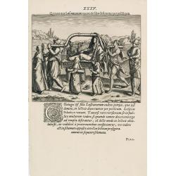
Lusitani in India deseruntur in Lecticis.
The way how the Portuguese carried a noble man in India from Linschoten's famous voyages to the East of 1583-92 here published by De Bry the year after they first appeare...
- $150 / ≈ €140
Place & Date: Frankfurt, 1599
Peregrinationes noctu devotionis ergo à Lusitanis in India susceptae.
Showing Portuguese family in India from Linschoten's famous voyages to the East of 1583-92 here published by De Bry the year after they first appeared as a separate book....
- $150 / ≈ €140
Place & Date: Frankfurt, 1599
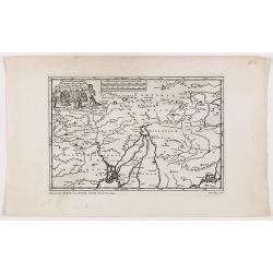
De Land-Reyse, door Benedictus Goes, van Lahor gedaan, door Tartaryen na China.
Interesting map showing the region of northeastern India, Nepal, Bhutan, Assam and Bangladesh. Canton in lower right corner.The map illustrates the narrative of the trave...
- $200 / ≈ €187
Place & Date: Leiden, 1707
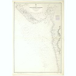
India west coast Gulf of Cutch to Vijaydurg . . .
Chart of India's west coast map surveyed by the hydrographer Captain JF Parry. A highly corrected version of Admiralty chart 2736 originally published 1st July 1915. Date...
- $200 / ≈ €187
Place & Date: London, 1915-1980
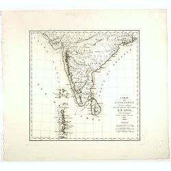
Presqu Isle de L'Inde. deca la Gange.. .
Two maps together on one sheet. General map showing the southern part of India, including the northern part of Shri Lanka. In an inset a detailed map of the most southern...
- $150 / ≈ €140
Place & Date: Amsterdam, 1700
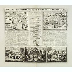
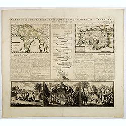
Genealogie des anciens empereurs mogols,. . .
Text sheet with two inset maps of "Carte de l'empire du grand Mogol (122x158mm.) and inset map of Kahsmire "carte nouvelle du royaume de Kachemire" (120x15...
- $150 / ≈ €140
Place & Date: Amsterdam, 1728
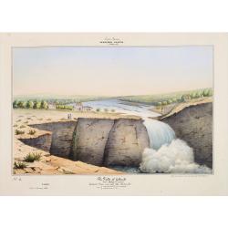
Southern - Concan.. - The falls of Gokank..
Hand colored lithography representing a view of the Gokak Falls, located on the Ghataprabha river. Plate N° 14. From Souvenirs d'un voyage dans l'Inde, exécuté de 1834...
- $250 / ≈ €234
Place & Date: Paris, 1843
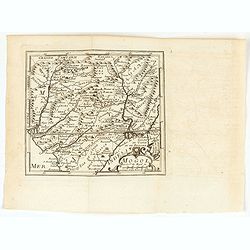
Mogol.
A very nice map of Northern India and Pakistan. From Francisco Giustiniani for El Atlas abreviado o el nuevo compendio de la Geografia universal, politica, historica, i c...
- $150 / ≈ €140
Place & Date: Leon de Francia (Lyon), Jaime Certa, 1739
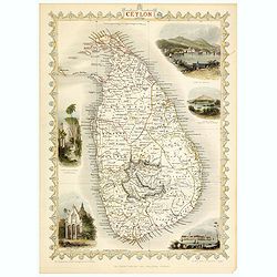
Ceylon.
Decorative steel engraved map of the Ceylon. The Illustrations and engraving by J Rapkin and H.Winckles. The Map was drawn and engraved by John Rapkin.John Tallis a Londo...
- $150 / ≈ €140
Place & Date: London, 1858
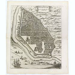
Negapatam.
Bird's-eye view of Nagapattinam or Negapatam, India, printed for the first Dutch edition of Baldaeus' work "A true and exact description of the most celebrated East-...
- $200 / ≈ €187
Place & Date: Amsterdam, 1672
Genealogie des empereurs Mogols . . .
Text sheet with two inset maps of "Carte de l'empire du grand Mogol (122x158mm.) and inset map of Kahsmire "carte nouvelle du royaume de Kachemire" (120x15...
- $150 / ≈ €140
Place & Date: Amsterdam, 1728
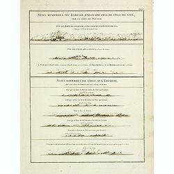
Vues diverses du fort de l'Agouade pres de l'isle de Goa . . . Sumatra . . .
French sea sea chart with 9 coastal views near Goa in India and Sumatra. The titles above the main profiles reading as following : Vues diverses du fort de l'Agouade pre...
- $200 / ≈ €187
Place & Date: Paris, Brest, Demonville, 1775
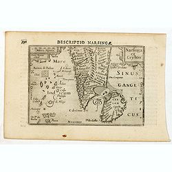
Descriptio Narsingae / Narsinga et Ceylon.
A rare miniature map of the southern part of India with Sri Lanka. The title cartouche on the upper right corner.First published in 1598 in his Caert-Thresoor, the plates...
- $350 / ≈ €328
Place & Date: Amsterdam, Cornelis Claes, 1606
Vue du serail du grand Mogol, des Indes.
Optical print of a Mogul Palace in India. Probably published by or after Jacques Chereau, who was a well-known publisher of optical prints, established in rue St. Jacques...
- $200 / ≈ €187
Place & Date: Paris, ca. 1750

Carte de la Baye et du Port de Trinquemalay Dans L'Isle de Ceylan.
French chart of the harbor of Trinquemalay on the island of Ceylon. Prepared after Samuel Cornish who was a vice admiral for the English East India company.Latitude and l...
- $350 / ≈ €328
Place & Date: Paris, Brest, chez Demonville, 1775
![The country Coromandel from the Coleroon to Cape Comorin. . . [with] The carnatic from the Pennar to the Coleroon. .](/uploads/cache/48363-250x250.jpg)
The country Coromandel from the Coleroon to Cape Comorin. . . [with] The carnatic from the Pennar to the Coleroon. .
Coromandel from the Coleroon to Cape Comorin. Elegant map in two sheets compiled for the East-India Company. In lower right margin : Writing by W. Harrison.
- $300 / ≈ €281
Place & Date: London, 1778
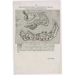
Delineatio Duorum Oppidorum, Ortat.
Early map of the Banda Islands.Theodore de Bry, a German engraver and book dealer, began a compilation of early voyages in 1590 and had published six parts at the time of...
- $200 / ≈ €187
Place & Date: Frankfurt, 1609
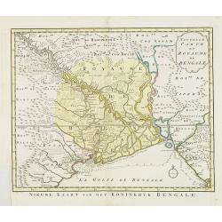
Nouvelle carte du Royaume de Bengale.
Uncommon issue of this detailed map of Bangladesh with the Ganges delta, including Calcutta. Giving great detail with trade routes, European trade settlements, etc. Prepa...
- $380 / ≈ €356
Place & Date: Amsterdam, 1773
![[Afghanistan].](/uploads/cache/44611-250x250.jpg)
[Afghanistan].
A scarce Russian relief map (in Russian) of Afghanistan published in Moscow during the Soviet occupation of the country during the early 1980s. Complete with a separate b...
- $250 / ≈ €234
Place & Date: Moscow, 1982
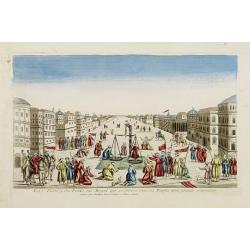
La Feste du Poids au Mogol qui se célebre chez ses Peuples avec grande vénération.
So-called optical print illustrating a perspective view of a square in Mongolia.Mondhare, active at rue St.Jacques a l'Hotel Saumur, was a well-known publisher of optical...
- $230 / ≈ €215
Place & Date: Paris, 1760
Magni Mogolis Imperium.
An attractive map of the region from Iran through Afghanistan, Tibet, and northern India across to Burma. The travel route from Kabul to Surat is the most prominent featu...
- $350 / ≈ €328
Place & Date: Amsterdam, 1644

Maldivae Insulae.
Very fine early miniature map of Maldives Islands. East is at the top. Title cartouche on the lower right corner. A dolphin and two ships are depicted.First published in ...
Place & Date: Amsterdam / Frankfurt, 1609
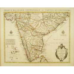
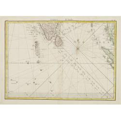
Carte des Côtes de Malabar et de Coromandel Presentée au Roy. . .
Large and attractive map of the Indian coasts of Malabar and Coromandel, embellished with title cartouche and 2 compass roses. It shows the most northern part of Ceylon.T...
- $500 / ≈ €468
Place & Date: Amsterdam c. 1745