Browse Listings in America > North America > California / Northwest Central
![[Map of the Monterey Peninsula.]](/uploads/cache/48349-250x250.jpg)
[Map of the Monterey Peninsula.]
A lovely example of Jo Mora's Del Monte Properties Company' California's Fun' playground tourist map of the Monterey Peninsular, published in San Francisco in 1927. The r...
- $900 / ≈ €842
Place & Date: San Francisco, 1927
![[Set of 2 maps] The Pageant of History in Northern California its colorful and adventuresome beginnings / The Panorama of Today in Northern California its resources, activities and opportunities.](/uploads/cache/48343A-250x250.jpg)
[Set of 2 maps] The Pageant of History in Northern California its colorful and adventuresome beginnings / The Panorama of Today in Northern California its resources, activities and opportunities.
An unusual and attractive pair of lithographed maps, issued by the American Trust Company, in San Francisco on the occasion of its centenary in 1954. It chose to do this ...
- $350 / ≈ €328
Place & Date: San Francisco, 1954
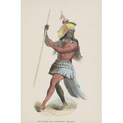
Een Danser der Californische Indiaanen.
Decorative, original hand colored, woodcut engraving illustrating a native American dancer from California.
- $35 / ≈ €33
Place & Date: Amsterdam, ca. 1860
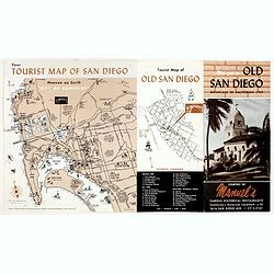
Welcome to old San Diego, birthplace of California 1769.
Publicity leaflet for "Manuel's Restauranté" in the Casa de Pedrorena. On one side a pictorial map of San Diego and "Tourist Map of Old San Diego", w...
- $75 / ≈ €70
Place & Date: San Diego, ca. 1935
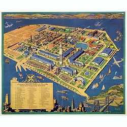
A cartograph of Treasure Island in San Francisco Bay Golden Gate International Exposition.
Ruth Taylor White's large format map of Treasure Island and the San Francisco Golden Gate Exposition Fairgrounds, published in 1940.The map provides an aerial panorama of...
- $200 / ≈ €187
Place & Date: San Francisco, 1940
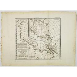
Carte de la Californie et des Pays Nord-Ouest. . . 4de Carte.
Diderot's famous 2 on 1 map shows the two early mappings of the west coast of North America, the first after Visscher, the second after Plancius' World map. Both show the...
- $200 / ≈ €187
Place & Date: Paris, 1779
![Noweav Mexiqve. [California as an Island]](/uploads/cache/26133-250x250.jpg)
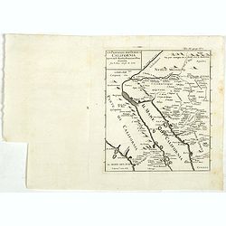
Noweav Mexiqve. [California as an Island]
Scarce miniature map of California as a island, from Pierre Duval's La Geographie Universeille. The second earliest map to focus on just California and the contiguous coa...
- $800 / ≈ €749
Place & Date: Paris, 1672

A Hysterical Map Of Death Valley National Monument -- And It's Looking Mighty Low
First edition Humorous map of Death Valley. "Drawn In Broken English by Jolly Lindgren," this comic pictorial map is full of puns and comic vignettes related to...
- $500 / ≈ €468
Place & Date: Spokane, Wash., Lindgren Brothers, 1948
Un Passaggio per Terra a California Scoperto dal P. Eusebio Francesco Kino Gesuita Fragli Anni 1698 et 1701.
The rare Italian edition of Father Eusebio Francisco Kino's seminal map, which definitively ended the myth of California as an Island, which appeared in Saggio delle tran...
- $1200 / ≈ €1123
Place & Date: Napples, 1731

Tartariae sive Magni Chami Imperium.
This is a very early depiction of the northern Pacific, with the first mapping of Northwest Coast of America and probably the first map to name California 'C. Califormio...
- $2500 / ≈ €2339
Place & Date: Antwerp, c. 1608-1612
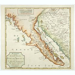
Kaart van het Westelyk Gedeelte van Nieuw Mexico en van California. . . MDCCLXV ..
A detailed map of the Baja California and Sonora, bounded on the north by the Colorado and Gila Rivers and approximately Mozatlan in the south, thus including parts of mo...
- $875 / ≈ €819
Place & Date: Amsterdam, 1765
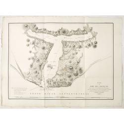
Plan du Port des Francais sur la Cote du Nord-Ouest de l'Amerique, par 58°37' de Latitude Nord et 139°50' de Longitude Occidentale, Decouverte le 2 Juillet 1786, par les Fregates Francaise la Boussole et l'Astrolabe.
Chart of the entrance of Bassin de L'Quest , visited on July 2nd 1786 by La Perouse. On many 18th century maps we find a depiction of Mer de L'Quest or Sea of the West a ...
- $500 / ≈ €468
Place & Date: Paris, 1798
![Noweav Mexiqve [California as an Island]](/uploads/cache/03796-250x250.jpg)
Noweav Mexiqve [California as an Island]
Uncommon miniature map of California as a island, from Pierre Duval's La Geographie Universeille in a second state. The map is derived from Audience de Guadalajara (1657)...
Place & Date: Paris, 1663

San Diego Bay. (Chart 5107)
Nautical chart of San Diego Bay of 1945. Printed in black, yellow and purple the "Seaward limit defensive sea area". The water area within the indicated limits ...
Place & Date: Washington, 1945

.Pascaerte Vande Zuyd-Zee tusschen California, en Ilhas de Ladrones. . .
A decorative and most interesting map - being one of the earliest of the Pacific to record the observations of Tasman's voyages. The northern part of the island of Califo...
Place & Date: Amsterdam, 1666