Browse Listings in America > North America
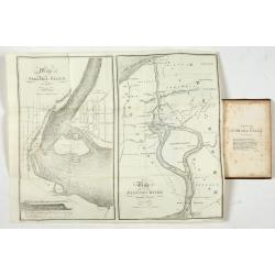
Map of Niagara Falls and viccinity.
This Fifth edition, revised and enlarged, is accompanied by 6 lithographs by Hall & Mooney depicting views of the falls and one map by H.A. Parsons entitled "Map...
- $150 / ≈ €140
Place & Date: Buffalo, 1838
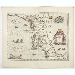
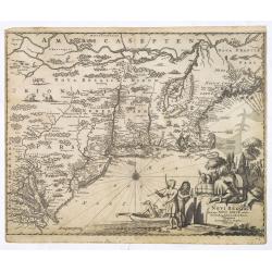
Nova Belgica et Anglia Nova.
Orientated with north to the right. This is one of the earliest maps to concentrate solely on this area of the colonies, excluding Virginia and the extreme north east coa...
- $4500 / ≈ €4211
Place & Date: Amsterdam, 1644
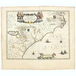
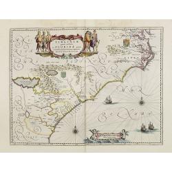
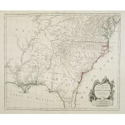
Virginiae Partis Australis, et Floridae Partis Orientalis.
Blaeu based this map on the Mercator-Hondius of 1606. A number of geographical improvements, however were incorporated, although two large fictions lakes accompanied by e...
- $2000 / ≈ €1871
Place & Date: Amsterdam, 1644
![[Lot of 5 maps] Kaart van de noord-west kust van Amerika en de noord-oost kust van Asia.](/uploads/cache/19136-250x250.jpg)
[Lot of 5 maps] Kaart van de noord-west kust van Amerika en de noord-oost kust van Asia.
- Kaart van de noord-west kust van Amerika en de noord-oost kust van Asia. Opgenoomen in de Jaaren 1778 en 1779. Captain James Cook (1728-79), explorer, circumnavigato...
Place & Date: Leiden, 1795-1803
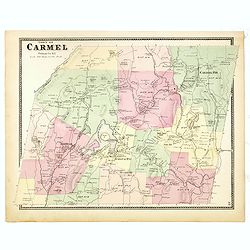
Town of Carmel.
Fine lithographed map of the town of Carmel. From : "Atlas of New York and vicinity" published by Beers, Ellis & Soule, 95 Maiden Lane, New York. The map pr...
Place & Date: New York, 1867
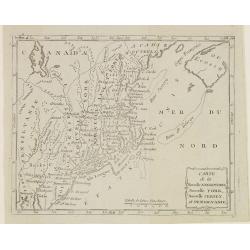
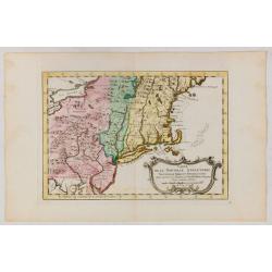
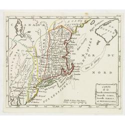
Carte de la Nouvelle Angleterre, Nouvelle York, Nouvelle Jersey, et Pensilvanie.
Map of the north eastern part of the United States, from Atlas de la Géographie de toutes les parties du monde .. Ouvrage destiné pour l'education, et nécessaire aux n...
Place & Date: Paris, Prudhomme, Levrault, Debray, 1806

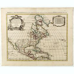
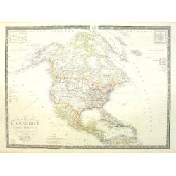
Amerique Septentrionalis..
A handsome map showing California as an island, open-ended Great Lakes and other details based mainly on Sanson. A large decorative cartouche occupies the area of the nor...
Place & Date: Paris, after1694

Région arctique.
Decorative map of the North Pole, prepared by Louis Vivien de Saint-Martin (* 22. Mai 1802 in Saint-Martin de Fontenay, died 3 January 1897 in Paris). He was one of the m...
Place & Date: Paris, Hachette, 1877
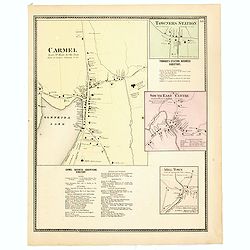
Town of Carmel / Towners Station / South East Centre / Mill Town.
Fine lithographed map of the town of Carmel / Towners Station / South East Centre / Mill Town. From "Atlas of New York and vicinity" published by Beers, Ellis ...
Place & Date: New York, 1867
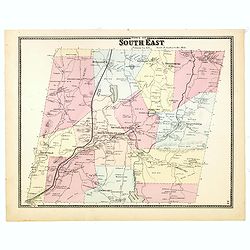
Town of South East.
Fine lithographed map of the town of South East. From : "Atlas of New York and vicinity" published by Beers, Ellis & Soule, 95 Maiden Lane, New York.The map...
Place & Date: New York, 1867
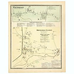
Town of Patterson / Brewsters Station.
Fine lithographed map of the town of Patterson / Brewsters Station. From : "Atlas of New York and vicinity" published by Beers, Ellis & Soule, 95 Maiden Lan...
Place & Date: New York, 1867
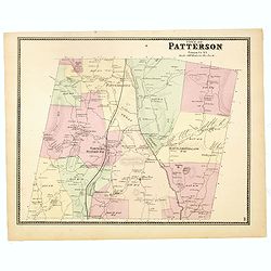
Town of Patterson.
Fine lithographed map of the town of Patterson. From : "Atlas of New York and vicinity" published by Beers, Ellis & Soule, 95 Maiden Lane, New York.The map ...
Place & Date: New York, 1867
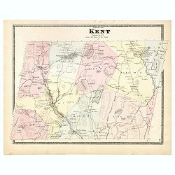
Town of Kent.
Fine lithographed map of the town of Kent. From :"Atlas of New York and vicinity" published by Beers, Ellis & Soule, 95 Maiden Lane, New York.The map provid...
Place & Date: New York, 1867

Upper Canada &c.
A beautiful, large scale map of Upper Canada, and portions of the American states of New York, Ohio, and Pennsylvania. The province of 'Upper' Canada was created by the B...
Place & Date: London, 1839
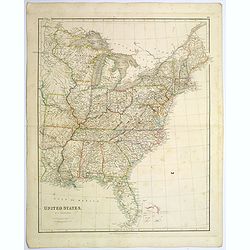
United States.
A lovely large map of the Untied States, as it was at the time of publication. Each state shown in a different outline color. Nothing is shown west of Louisiana, Arkansas...
Place & Date: London, 1839

Nieuwe Kaart van de Grootbrittannische Volkplantingen in Noord America waar in Tevens de Fransche Bezittingen en de Landen tuschen die Beide Volken. . .
A map of the east-coast of America from New Foundland till Florida, divided in French and British properties. Reduced size Dutch edition of Mitchell's map of North Americ...
Place & Date: Amsterdam, 1769
![[The manner of making their boats.]](/uploads/cache/40467-250x250.jpg)
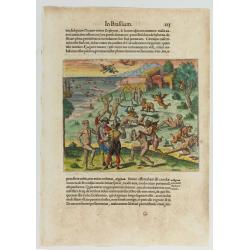
[The manner of making their boats.]
The manner of making boats in Virginia is wonderful to behold. They were able to do so without using any iron tool at all. First they chose a tall tree, wide enough for a...
Place & Date: Frankfurt, M.Merian, 1633
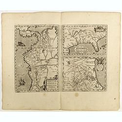
La Florida/ Peruviae Auriferae regionis Typus/ Guastecan.
The Chaves map of Florida is a prime example of an explorer's map since it records the recent discoveries of Cabeza de Vaca, De Soto, and Moscoso. The map revealed little...
Place & Date: Antwerp, 1598
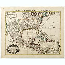
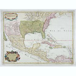
Carte du Mexique et des Etats Unis d'Amérique...
A later edition of De l'Isle's foundation map of 1703, widely regarded as one of the most influential maps in the history of American Cartography. This updated version of...
Place & Date: Paris, 1783
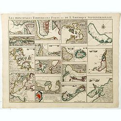
Les Principales Forteresses Ports &c de L'Amérique Septentrionale. . .
This sheet contains 19 small but detailed maps and plans of harbours, towns, forts and islands from the eastern seaboard and the West Indies, all but one plan with title ...
Place & Date: Amsterdam, 1733

Carte nouvelle de l'Amérique angloise contenant tout ce que les Anglois possèdent. . . avec la Floride / gravée. . . par Maththias Albert Lotter. . .
As mentioned in the title piece, the map includes the area at that time in the possession of the English, i.e. Canada, New Large, beautiful and detailed map of the Easter...
Place & Date: Augsburg, 1777
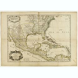
Carte du Mexique et de la Floride, des terres angloises et des isles Antilles, du cours et des environs de la rivière Mississipi. . .
A Dutch edition of De L'Isle's map. It was the first printed map to portray accurately the course and mouth of the Mississippi River. Showing the explorations of d'Ibervi...
Place & Date: Amsterdam, 1722
L'Amerique septentrionale, Dressée sur les memoires les plus recens. . .
A very detailed map extending from Hudsons Bay to Panama, and including the West Indies. The map is a later copy of Guillaume de L'Isle's foundation map of North America,...
Place & Date: Amsterdam, 1739
![[In Arabic, translates : A map of the United States of America shows its major regional ressources and its natural products]](/uploads/cache/43010-250x250.jpg)
[In Arabic, translates : A map of the United States of America shows its major regional ressources and its natural products]
Chromolithographed pictorial poster of the United States in Arabic language. Showing the United States' main products, regional resources and physical features. The map i...
Place & Date: Washington D.C., ca. 1965

Vue de la Rue du Roi, vers la Porte de la Campagne a Boston.
A vue d'optique of the city of Boston. A view of a typical Bostonian street, with buildings opening directly onto the throughway, groups of people, gentlemen, workers and...
Place & Date: Augsburg, 1762

Nova tabula geographica complectens borealiorem..
A finely engraved pair of maps designed to be cut and joined together to provide a continuous coastline of North America from the Carolinas to Newfoundland and along the ...
Place & Date: Amsterdam 1720
![[Native Americans of village at Nootka Sound].](/uploads/cache/44726-250x250.jpg)
[Native Americans of village at Nootka Sound].
Aquatint depicting people in a Nootka Sound village engraved by A.D Rossi, Plate N° 12 From Giulio Ferrario's work Le Costume Ancien et Moderne ou Histoire du gouverneme...
Place & Date: Milan, 1827
![[No title]. [Alaska-North American village with boats].](/uploads/cache/44728-250x250.jpg)
[No title]. [Alaska-North American village with boats].
Aquatint depicting a fishing scene engraved by Paolo Fumagalli, Plate N° 20 From Giulio Ferrario's work Le Costume Ancien et Moderne ou Histoire du gouvernement, de la m...
Place & Date: Milan, 1827
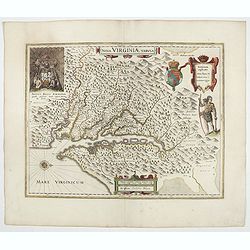
Nova Virginiae Tabula.
The map is based on the first state of Smith's map, 1612, and is slightly larger and more expertly engraved. In 1629 the Hondius plate was purchased by Blaeu who deleted ...
Place & Date: Amsterdam, 1644
Carte du Mexique et des Etats Unis d'Amérique…
A later edition of De l'Isle's foundation map of 1703, widely regarded as one of the most influential maps in the history of American Cartography. This updated version o...
Place & Date: Paris, 1783

La parte orientale dell' antico.. messico con la Florida..
A splendid two-sheet map of Mexico, including California, Arizona, New Mexico, part of Texas, Baja California and Mexico (west part) and of the Southeast Part of the US, ...
Place & Date: Rome, Calcography, 1797-before 1839

Mappa geographica Provinciæ Nova Eboraci ab Anglis New-York . . .
Lower part of the two sheets map of Homann Heirs' edition of Sauthier's celebrated map of New York and New Jersey, made during the Revolutionary War. Appears in Homann's ...
Place & Date: Nuremburg, 1778
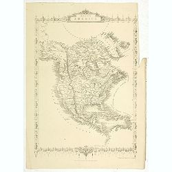
North America.
Map of North America, published by "The London Printing and Publishing Company". Drawn and engraved by John Rapkin.
- $100 / ≈ €94
Place & Date: London, 1854
![[Lake George and the village of Caldwell.]](/uploads/cache/26087-250x250.jpg)
[Lake George and the village of Caldwell.]
A proof state without the text of Lake George and the village of Caldwell after Jacques Milbert, and lithographed by Sabartier.From Amérique Septentrionale. Printed by H...
- $100 / ≈ €94
Place & Date: Paris, 1829
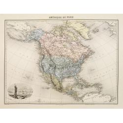
Amérique du Nord.
Decorative map of Northern America from Géographie Universelle, Atlas Migeon. published by J. Migeon. Nice engraving at the lower left hand of New York with the Statue o...
- $125 / ≈ €117
Place & Date: Paris, 1874
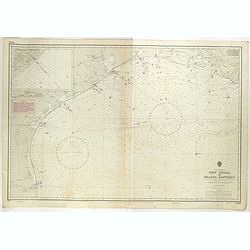
Gulf of Mexico. Ship Shoal to Brazos Santiago.
A large sea chart of the Gulf of Mexico, Ship Shoal to Brazos Santiago, 'from Admiralty Charts and US Government charts, corrected to 1943'. (In fact there are correction...
- $200 / ≈ €187
Place & Date: London, 1943 updated to 1951

Tierra Nueva.
Uncommon first edition of this early map of the east coast is an enlarged version of Giacomo Gastaldi map published in 1548. Nomenclature and cartography are unchanged, w...
- $1000 / ≈ €936
Place & Date: Venice, 1561
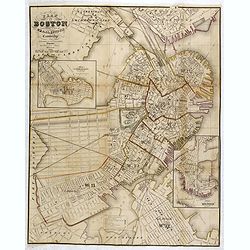
Plan Of Boston Comprising a Part of Charlestown and Cambridge. Published by George G. Smith, Engraver, Washington Street Boston 1855..
Important and detailed plan of Boston, with insets :"Plan Of East Boston from actual Survey by R.H. Eddy" and "Plan Of South Boston From a Drawing by S.P. ...
- $1250 / ≈ €1170
Place & Date: Boston, ca. 1859
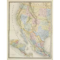
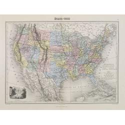
Etats Unis (Etats de l' Ouest).
Large format highly detailed map of the states and territories of the West, with Central America, included in a large inset titled "Etats de l'Amerique Centrale"...
- $400 / ≈ €374
Place & Date: Paris, 1889

Carte Générale du Canada, de la Louisiane, de la Floride, de la Caroline..
Map of the eastern part of the United States and Canada. With inset map of Hudson and Baffin bays. in the lower right corner.Venetian edition of d'Anville's map, from &qu...
- $750 / ≈ €702
Place & Date: Venice, 1776 - 1784
Virginiae Partis Australis, et Floridae Partis Orientalis.
Blaeu based this map on the Mercator-Hondius of 1606. A number of geographical improvements, however were incorporated, although two large fictions lakes accompanied by e...
- $1500 / ≈ €1404
Place & Date: Amsterdam, 1658
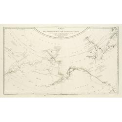
Karte von den N.W.Amerikanische und N.O.E. Asia..
A detailed large-scale map showing the Bering strait, Kamchatka, Alaska, and much of North America. While the Russian coastline is shown with reasonable accuracy. Showing...
- $500 / ≈ €468
Place & Date: Vienna 1788
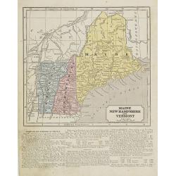
Maine, New Hampshire and Vermont.
Map of Maine, New Hampshire and Vermont.. On the verso, a world map of North and South America with its northern and southern hemispheres. From Sidney E. Morse''s: System...
- $30 / ≈ €28
Place & Date: New York, 1855
![[Foggia di vestive degli Abitanti del Porto dei Francesi.' [Alaska-North American Indians].](/uploads/cache/44730-250x250.jpg)
[Foggia di vestive degli Abitanti del Porto dei Francesi.' [Alaska-North American Indians].
Aquatint depicting a tribe meeting engraved by A.T Biasioli, Plate N° 13. : 'Foggia di vestive degli Abitanti del Porto dei Francesi.' showing Alaska-North American Indi...
- $90 / ≈ €84
Place & Date: Milan, 1827
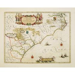
Virginiae Partis Australis, et Floridae Partis Orientalis.
Blaeu based this map on the Mercator-Hondius of 1606. A number of geographical improvements, however were incorporated, although two large fictions lakes accompanied by e...
- $1800 / ≈ €1684
Place & Date: Amsterdam, 1640
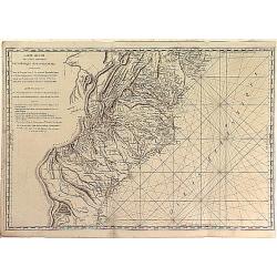
Carte Réduite des Côtes Orientales Del'Amérique Septentrionale Contenant partie du Nouveau Jersey, la Pen-sylvanie, le Mary-land, la Virginie, la Caroline Septentrionale, la Caroline Méridionale et la Georgie. . .
Scarce Rome edition of an French map made expressly for use of the French Navy during the American Revolution. Covering the area of Maryland, North and South Virginia. Ph...
- $900 / ≈ €842
Place & Date: Genova, Yves Gravier, c.1800

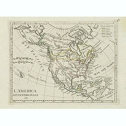
America settentrionale. . .
Rare map of North America drawn directly from the work of Nicholas De Fer and N. Sanson's famous map of 1650. The map is engraved by Antonius Donzel Gallus.With open Grea...
- $2000 / ≈ €1871
Place & Date: Napels, 1766
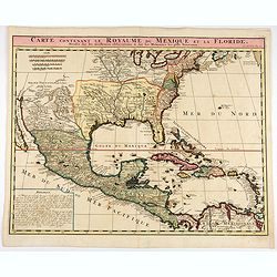
Carte contenant le Royaume du Mexique et la Floride.
This is a derivative of Delisle's landmark map of the southern part of North America.The detailed map shows many English settlements along the East Coast and carefully no...
- $1000 / ≈ €936
Place & Date: Amsterdam, 1719
Carte de la Nouvelle Angleterre, Nouvelle York et Pensilvanie / Pour servir à l'Histoire Générale des Voyages.
Uncommon edition of this accurate map the east coast from Delaware River till Main.Left hand corner Lake Ontario. In lower right engraved "38."From Atlas Portat...
- $275 / ≈ €257
Place & Date: Amsterdam, 1773
Etats-Unis.
Decorative map of the United States from Géographie Universelle, Atlas Migeon. Oklahoma is Indian Territory with Public Lands in the panhandle. With an engraving lower l...
- $75 / ≈ €70
Place & Date: Paris, 1874
![[Map of the Monterey Peninsula.]](/uploads/cache/48349-250x250.jpg)
[Map of the Monterey Peninsula.]
A lovely example of Jo Mora's Del Monte Properties Company' California's Fun' playground tourist map of the Monterey Peninsular, published in San Francisco in 1927. The r...
- $900 / ≈ €842
Place & Date: San Francisco, 1927
![[Set of 2 maps] The Pageant of History in Northern California its colorful and adventuresome beginnings / The Panorama of Today in Northern California its resources, activities and opportunities.](/uploads/cache/48343A-250x250.jpg)
[Set of 2 maps] The Pageant of History in Northern California its colorful and adventuresome beginnings / The Panorama of Today in Northern California its resources, activities and opportunities.
An unusual and attractive pair of lithographed maps, issued by the American Trust Company, in San Francisco on the occasion of its centenary in 1954. It chose to do this ...
- $350 / ≈ €328
Place & Date: San Francisco, 1954
Partie Méridionale de la Louisiane, avec la Floride, la Caroline et la Virginie..
Fine map of southeastern part of the United States after d'Anville's, to whom Santini gives credit in the cartouche.It covers the Atlantic coastline between the Chesapeak...
Place & Date: Venice, 1776 - 1784
Selling price: $1500
Sold in 2008
Carte de la Nouvelle Angleterre, Nouvelle York, Nouvelle Jersey, et Pensilvanie.
Highly detailed regional map of the Northeastern US, featuring numerous place names, Forts, Native American tribes, rivers,coastal banks, and other details. This is a Fre...
- $250 / ≈ €234
Place & Date: Paris, 1780

Novum Amsterodamum. . .
Three engravings on one page are set in a decorative, separately engraved border. - In the upper left is a good example of one of the earliest available views of New York...
- $1200 / ≈ €1123
Place & Date: Leiden, 1729
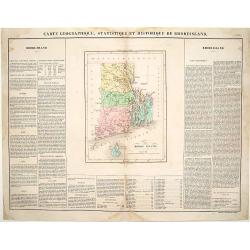
Carte Géographique, statistique et historique du Rhode Island.
Detailed map of Rhode Island. From J.A. Buchon, Atlas Gégraphique Statistique, historique et chronologique des deux Amériques et des isles adjacentes, traduit de l'atla...
- $175 / ≈ €164
Place & Date: Paris, 1825
![[ Road and Bridge over the Mohawk ].](/uploads/cache/26088-250x250.jpg)
[ Road and Bridge over the Mohawk ].
Uncommon proof state without the text of Road and Bridge over the Mohawk after Jacques Milbert, and lithographed by Sabartier.From Amérique Septentrionale. Printed by He...
- $150 / ≈ €140
Place & Date: Paris, 1829
Novi Belgii, quod nunc Novi Jorck vocatur, Novaeque Anglia et partis Virginiae. . .
A beautifully engraved map, derived from the highly influential map by Visscher. The decoration of this finely engraved map has in the lower right corner not longer a vie...
Place & Date: Amsterdam, 1673
Selling price: $1000
Sold in 2016
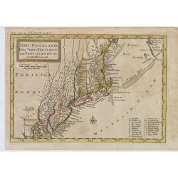
Neu Engeland Neu York, Neu Jersey und Pensilvanien & c. . .
The scarce German edition of Moll's popular and rather significant map which appeared in Oldmixon's 1708 book, Das Britische Reich in America. and then in other editions ...
- $450 / ≈ €421
Place & Date: Lemgo, 1744
Nouvelle carte de l'Amérique Septentrionale et des iles qui en dépendent dressée par H. Brué. . .
Very large, highly detailed, and uncommon issue of the map of North and Central America (ca. 1:13,888,000) prepared by H. Brué and improved by A.Vuillemin. Showing main ...
- $500 / ≈ €468
Place & Date: Paris, 1875
L'America septentrionale.
Charming and finely engraved map of North America from the rare atlas Atlante Tascabile o sia Serie di Num. XXI Cartine Geografiche nelle quali si rappresenta in ristrett...
- $275 / ≈ €257
Place & Date: Rome, 1823

Nova Virginia Tabula.
A beautifully engraved map, derived from the highly influential map by Captain John Smith in 1612, showing Chesapeake Bay and the surrounding area. The decoration of this...
- $1250 / ≈ €1170
Place & Date: Amsterdam, J.Meurs, 1671
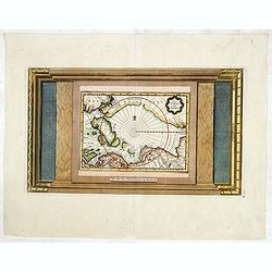
La Terre du Nord.
Map of the Arctic Circle, set within a series of decorative borders, printed from a different copper plate. All counties that lie within or near to the North Pole are sho...
- $750 / ≈ €702
Place & Date: Amsterdam, 1713
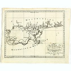
Charte von der mündung des Mississippi. Weimar, Verlage des Landes Indust. Compt. 1803.
Scarce map showing the mouth of the Mississippi into the Gulf of Mexico. With Pensacola in Western Florida, Mobile Bay in Alabama and Louisiana with New Orleans and their...
- $300 / ≈ €281
Place & Date: Weimar, 1803
Cacodemon attacking the savages.
Cacodemon ("evil spirit") attacking the savages. Read more about "Les Grand Voyages" by Theodore De Bry [+]
- $200 / ≈ €187
Place & Date: Frankfurt, 1594
Die Vereinigten Staaten von Nord-Amerika.
Nice little German map of the early United States. The only state shown west of the Appalachian Mountains is Kentucky. Above which is a strangely shaped unnamed region (O...
- $250 / ≈ €234
Place & Date: Augsburg, 1812
Carte de la Louisiane et du Cours du Mississipi Dressée sur un grand nombre de Memoires. . .
Covens & Mortier's issue of Delisle's influential map of the French possession of Louisiana. Updated to include New Orleans.When originally published in 1718, it was ...
Place & Date: Amsterdam, c. 1745
Selling price: $1400
Sold in 2010
L'Amerique septentrionale, Dressée sur les memoires les plus recens. . . MDCCLVII
A rare map of North America, showing good detail, especially in the region between the Appalachians and the Mississippi and the course o the Mississippi to its source, wh...
- $1500 / ≈ €1404
Place & Date: Amsterdam, 1757
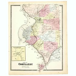
Town of Cortlandt.
Fine lithographed map of the town of Cortlandt. The map provides the names of specific homeowners, as well as information about the occupations and physical locations of ...
- $90 / ≈ €84
Place & Date: New York, 1867
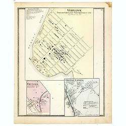
Town of Verplanck / Crugers / Croton Landing.
Fine lithographed map of the town of Verplanck / Crugers / Croton Landing. The map provides the names of specific homeowners, as well as information about the occupations...
- $90 / ≈ €84
Place & Date: New York, 1867
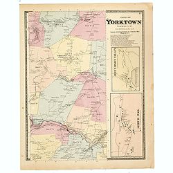
Town of Yorktown.
Fine lithographed map of the town of Yorktown. The map provides the names of specific homeowners, as well as information about the occupations and physical locations of t...
- $90 / ≈ €84
Place & Date: New York, 1867
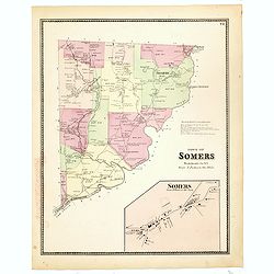
Town of Somers.
Fine lithographed map of the town of Somers. The map provides the names of specific homeowners, as well as information about the occupations and physical locations of the...
- $90 / ≈ €84
Place & Date: New York, 1867
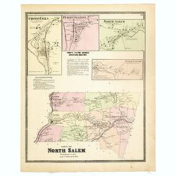
Town of North Salem.
Fine lithographed map of the town of North Salem. The map provides the names of specific homeowners, as well as information about the occupations and physical locations o...
- $90 / ≈ €84
Place & Date: New York, 1867
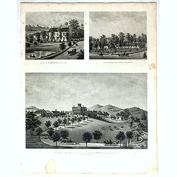
Property of F.A.Halstead Bedford Station, The Halstead Homestead at Bedford and Inland Vale residence of J.S.Libby, Westchester Co. NY North Salem.
Three heliographic prints on one sheet : "Property of F.A.Halstead Bedford Station", "The Halstead Homestead at Bedford" and "Inland Vale residen...
- $100 / ≈ €94
Place & Date: New York, 1867
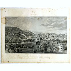
View of Brewsters' Putnam Co.N.Y.
Heliographic print of Brewsters' Putnam Co.N.Y." after a design by R.K.Sneden.From Beer's famous county atlas "Atlas of New York and vicinity, a documentary rec...
- $100 / ≈ €94
Place & Date: New York,1867
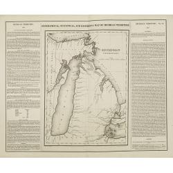
Geographical, statistical, and historical map of Michigan territory.
The first printed map of Michigan Territory. Text around the map describes the Topography, Climate, Animals, Civil Divisions, Population, Towns & Forts, Government, H...
- $500 / ≈ €468
Place & Date: Philadelphia, 1822

P.les de Virginie.
Attractive copper engraving, depicting a couple of native people of Florida.From the French text edition of Description d'Univers, 1683. by Allain Manneson Mallet (1630-1...
- $110 / ≈ €103
Place & Date: Paris, 1683
![[North America]](/uploads/cache/25907-250x250.jpg)
[North America]
Uncommon map of North America. The young United States incorporates the upper Midwest, with the remaining western territories of Louisiana, Nouveau Mexique, Nouveau Albio...
- $1000 / ≈ €936
Place & Date: Augsburg, ca. 1790
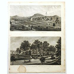
Résidence of WM H.Drew Southeast Putnam Co.N.Y / Lake Farm Résidence of John V.Storm East Fiskill Dutches Co.N.Y.
Two heliographic prints on one sheet : " Résidence of WM H.Drew Southeast Putnam Co.N.Y / Lake Farm Résidence of John V.Storm East Fiskill Dutches Co.N.Y." af...
- $100 / ≈ €94
Place & Date: New York,1867

The Greyhound Map of This Amazing America. . .
A large colored lithograph map of the USA, published by the Greyhound Corporation during the second world war. The map demonstrates where all the Greyhound bus routes int...
- $150 / ≈ €140
Place & Date: United States, 1941