Browse Listings in America > North America
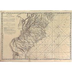
Carte Réduite des Côtes Orientales Del'Amérique Septentrionale Contenant partie du Nouveau Jersey, la Pen-sylvanie, le Mary-land, la Virginie, la Caroline Septentrionale, la Caroline Méridionale et la Georgie. . .
Scarce Rome edition of an French map made expressly for use of the French Navy during the American Revolution. Covering the area of Maryland, North and South Virginia. Ph...
- $900 / ≈ €842
Place & Date: Genova, Yves Gravier, c.1800

Nader prolongatie van het Octroy voor de Westindische Compagnie voor den tyd van nog dertig jaaren. . .
A proclamation by the Dutch States General, dated 1761, extending the charter of the Dutch West India Company for another thirty years. Like the 1730 proclamation, it has...
Place & Date: Amsterdam, 1761

Pascaerte van Carybes, Nieu Neder landt, Brazil. . .
This progenitor chart covers the American shores of the Atlantic Ocean. This chart by Theunis Jacobsz. was most probably engraved close to his death in 1650 or shortly af...
- $2200 / ≈ €2059
Place & Date: Amsterdam, 1653-1681

Nova Virginiae tabula.
A fine example of Blaeu's map of Virginia and the Chesapeake region is based on the first state of Smith's map, 1612, and is slightly larger and more expertly engraved.Th...
Place & Date: Amsterdam, 1635/1660

L'Amerique Septentrionale.
Very rare map, from "Metaphaste Barbao, Descriptio Indiae Occidentalis et America Nova" published by Henrico Verdussen.The map is a copy of Guillaume de L'Isle'...
- $1250 / ≈ €1170
Place & Date: Antwerp, 1702
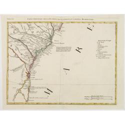
Parte Orientale della Florida, della Giorgia, e Carolina. . .
Attractive map covering the coast from S.Augustine till Long Bay, including Jacksonville, Savannah. From Zatta's Atlante Novissimo.
- $350 / ≈ €328
Place & Date: Venice, 1778
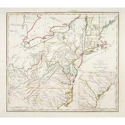
Gedeelte van den Vereenigden Staat van Noord Amerika.
A rare an detailed map of the eastern part of the United States of America. After Isaac Weld's map from his Travels through the States of North America 1799. Barbara Back...
- $650 / ≈ €608
Place & Date: Netherlands c. 1820
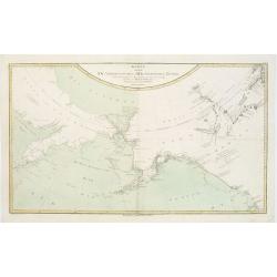
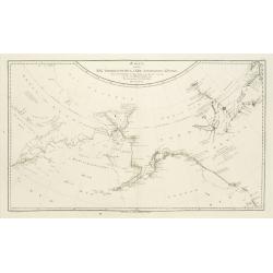
Karte von den N.W. Amerikanischen und N.OE. Asiatischen Kusten nach den Untersuchungen des Kapit. Cook...
A detailed large-scale map showing the Bering Strait, Kamchatka, Alaska and much of North America. While the Russian coastline is shown with reasonable accuracy. Showin...
- $450 / ≈ €421
Place & Date: Vienna, 1788
Karte von den N.W.Amerikanische und N.O.E. Asia..
A detailed large-scale map showing the Bering strait, Kamchatka, Alaska, and much of North America. While the Russian coastline is shown with reasonable accuracy. Showing...
- $500 / ≈ €468
Place & Date: Vienna 1788
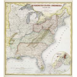
Die Vereinigten Staten von Nordamerika (Ostlicher theil).
Detailed map of eastern part of the United states until the border of Texas. In lower right hand corner inset map of New York Bay, including, NY, Newark, Staten Island.Th...
- $450 / ≈ €421
Place & Date: Weimar, 1874