Browse Listings in America > North America

Dominia Anglorum in America Septentrionali.
Four maps on one sheet (New Found land/ New England/ Virginia and Carolina/Florida) based on J.B.Homann's map, showing British possessions in North America. At bottom of ...
- $1500 / ≈ €1404
Place & Date: Nuremberg 1740
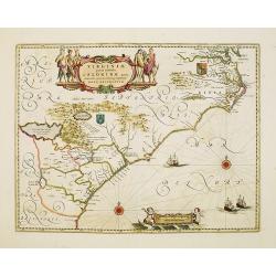
Virginiae Partis Australis, et Floridae Partis Orientalis.
Blaeu based this map on the Mercator-Hondius of 1606. A number of geographical improvements, however were incorporated, although two large fictions lakes accompanied by e...
- $1800 / ≈ €1684
Place & Date: Amsterdam, 1640
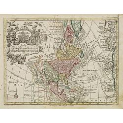
Nov' Orbis Sive America Septentrionalis. . .
Miniature map of North America, a reduction of the appropriate part of Seutter's folio map of the Americas, drawn by Albert Seutter. An unusual looking map, its projectio...
- $250 / ≈ €234
Place & Date: Augsburg, J.M.Will, 1778

Vue de Boston vers le Cale du Port.
A view of the port of Boston, the center of New England shipping in the colonial period. The closing of the port after the Boston Tea Party led to the calling of the Firs...
Place & Date: Augsburg 1762

Carte des parties Nord et est de l'Asie.. (5 maps on one sheet)
Five maps on one sheet, showing California, Alaska and Syberia, Korea and Japan. South to Korea the island "Quelpaerts".The map is from Diderot's "Encyclop...
- $200 / ≈ €187
Place & Date: Paris, 1772

Poli Arctici, et circumiacentium terrarum descriptio novissima. . .
A re-issue of the Hondius' plate. A particularly decorative map of the North Pole with Iceland. Several Dutch names in Labrador. The toponymy in Canada reflects the conti...
Place & Date: Amsterdam, 1660
![Noweav Mexiqve [California as an Island]](/uploads/cache/03796-250x250.jpg)
Noweav Mexiqve [California as an Island]
Uncommon miniature map of California as a island, from Pierre Duval's La Geographie Universeille in a second state. The map is derived from Audience de Guadalajara (1657)...
Place & Date: Paris, 1663
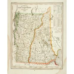
Neueste Karte von New Hampshire und Vermont.
Detailed map of New Hampshire and Vermont with numerous physical and political features including mines, settlements, trails/roads, forts and Indian areas. From Meijers H...
- $150 / ≈ €140
Place & Date: Hildburghausen/ Philadelphia, 1846
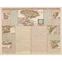
Carte qui contient..Iles & Terres..L'Amerique..Jamaique..
Eight maps on one sheet. From Chatelain's Atlas Historique et Méthodique . Including maps of Bermuda, Jamaica, New England with Long Island, Carolina, Chesapeake and Del...
Place & Date: Amsterdam, 1728
![Etats-Unis de L'Amerique Septentrionale. [Two sheets in manuscript ]](/uploads/cache/03972-250x250.jpg)
Etats-Unis de L'Amerique Septentrionale. [Two sheets in manuscript ]
Two sheets giving an detailed information in French, about population in the year 1810, principal cities, products of industry and commerce, financial situation for the y...
- $2000 / ≈ €1871
Place & Date: France, ca. 1819