Browse Listings in America > North America
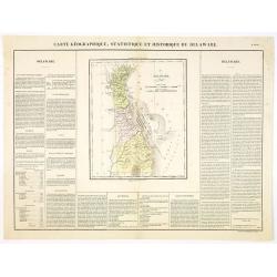
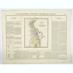
Carte Géographique .. Delaware.
Detailed map of Delaware. From J.A. Buchon, Atlas Gégraphique Statistique, historique et chronologique des deux Ameriques et des isles adjacentes, traduit de l'atlas ex�...
- $300 / ≈ €281
Place & Date: Paris, 1825
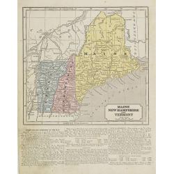
Maine, New Hampshire and Vermont.
Map of Maine, New Hampshire and Vermont.. On the verso, a world map of North and South America with its northern and southern hemispheres. From Sidney E. Morse''s: System...
- $30 / ≈ €28
Place & Date: New York, 1855
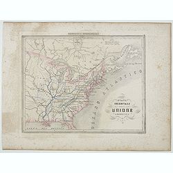
Stati Orientali della Unione Americana.
Uncommon map of Northeastern America prepared by Francesco Costantino Marmocchi. Above the map "Geografia Commerciale". From "Il Globo Atlante di carte Geo...
- $50 / ≈ €47
Place & Date: Genova, Paolo Rivara fu Giacomo, 1858

Danse d'indiens.
From Giulio Ferrario's work Le Costume ancien et moderne ou histoire du gouvernement, de la milice, de la religion, des arts, etc. published in Milan by the author betwee...
- $50 / ≈ €47
Place & Date: Milan, 1827
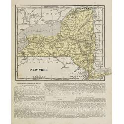
New York.
Map of New York. From Sidney E. Morse''s: System of Geography for the use of schools , published by Harper and brothers, 329 Pearl Street, New York.An 150 years old map w...
- $30 / ≈ €28
Place & Date: New York, 1855
![[The manner of making their boats.]](/uploads/cache/40467-250x250.jpg)
[The manner of making their boats.]
The manner of making boats in Virginia is wonderful to behold. They were able to do so without using any iron tool at all. First they chose a tall tree, wide enough for a...
Place & Date: Frankfurt, M.Merian, 1633
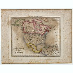
Nuovo Mondo parte Settentrionale.
Uncommon map of North America prepared by Francesco Costantino Marmocchi. Above the map "Geografia Commerciale". From "Il Globo Atlante di carte Geografich...
- $50 / ≈ €47
Place & Date: Genova, Paolo Rivara fu Giacomo, 1858

Een Danser der Californische Indiaanen.
Decorative, original hand colored, woodcut engraving illustrating a native American dancer from California.
- $35 / ≈ €33
Place & Date: Amsterdam, ca. 1860
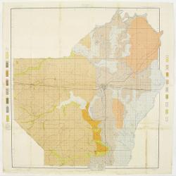
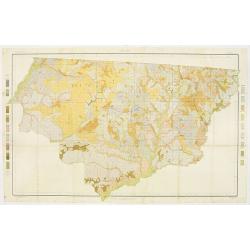
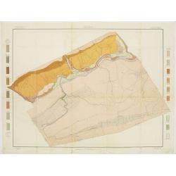
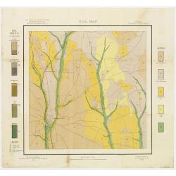
Soil map - Louisiana, Ouachita sheet.
Early color lithographed soil map by Julius Bien & Co. in New York for Department of Agriculture. Legends at side give detail on soil type, etc. They also include int...
- $40 / ≈ €37
Place & Date: New York, 1903
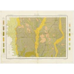
Soil map - Mississippi, McNeill sheet.
Soil map printed by Julius Bien & Co in New York for Department of Agriculture. The map is giving great detail of the area McNeill, Mississippi, in the year 1903. Soi...
- $50 / ≈ €47
Place & Date: New York, 1903
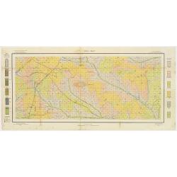
Soil map - Georgia, Fort Valley sheet.
Early color lithographed soil map by Julius Bien & Co. in New York for Department of Agriculture. Legends at side give detail on soil type, etc. They also include in...
- $50 / ≈ €47
Place & Date: New York, 1903
Soil map - Florida, Gadsden County sheet.
Early color lithographed soil map by Julius Bien & Co. in New York for the Department of Agriculture. Legends at the side give detail on soil type, etc. They also inc...
- $40 / ≈ €37
Place & Date: New York, 1903
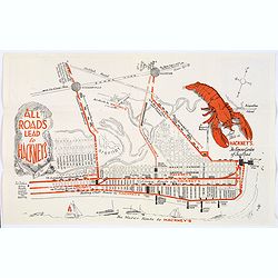
Map of Atlantic City to Hackney's Famous Garden of Sea Food . . .
A mid 1950s brochure for the famous Atlantic City Seafood Restaurant - 'Hackneys'. One side proclaims that "All Roads lead to Hackney's". It shows a nice plan o...
- $50 / ≈ €47
Place & Date: New Jersey, ca 1954
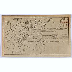
Little Egg Harbour.
A small sea chart showing Little Egg Harbour east of Tucker's Island. This map was published in the “American Coast Pilot”, a detailed guide to harbors, capes and hea...
- $50 / ≈ €47
Place & Date: New York, 1817
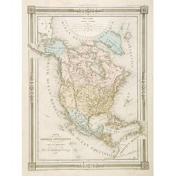
Carte L'Amérique Septentrionale..
Detailed map of North America, prepared by J.G.Barbié du Bocage.Engraved by Ch.Smith, published by Basset who was established in Paris, rue de Seine 33.
- $100 / ≈ €94
Place & Date: Paris, 1848
Soil map - Pennsylvania, Lockhaven sheet.
Early color lithographed soil map by Julius Bien & Co. in New York for Department of Agriculture. Legends at side give detail on soil type, etc. They also include int...
- $50 / ≈ €47
Place & Date: New York, 1903
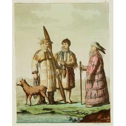
Les Aleuts.
From Giulio Ferrario's work Le Costume ancien et moderne ou histoire du gouvernement, de la milice, de la religion, des arts, etc. published in Milan by the author betwee...
- $50 / ≈ €47
Place & Date: Milan, 1827
![[ Road and Bridge over the Mohawk ].](/uploads/cache/26088-250x250.jpg)
[ Road and Bridge over the Mohawk ].
Uncommon proof state without the text of Road and Bridge over the Mohawk after Jacques Milbert, and lithographed by Sabartier.From Amérique Septentrionale. Printed by He...
- $150 / ≈ €140
Place & Date: Paris, 1829
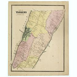
Town of Yonkers Westchester Co. NY
Fine lithographed map of the town of Yonkers. The map provides the names of specific homeowners, as well as information about the occupations and physical locations of th...
- $150 / ≈ €140
Place & Date: New York, 1867
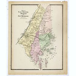
Plans of East Chester Pleham and New Rochelle. Westchester Co.
Fine lithographed map of East Chester Pelham and New Rochelle. The map provides the names of specific homeowners, as well as information about the occupations and physica...
- $100 / ≈ €94
Place & Date: New York, 1867
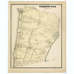
Town of Greenburgh.
Fine lithographed map of the town of Greenburgh. The map provides the names of specific homeowners, as well as information about the occupations and physical locations of...
- $100 / ≈ €94
Place & Date: New York, 1867

P.les de Virginie.
Attractive copper engraving, depicting a couple of native people of Florida.From the French text edition of Description d'Univers, 1683. by Allain Manneson Mallet (1630-1...
- $110 / ≈ €103
Place & Date: Paris, 1683
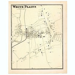
White Plains.
Fine lithographed map of White Plains. The map provides the names of specific homeowners, as well as information about the occupations and physical locations of the vario...
- $125 / ≈ €117
Place & Date: New York, 1867
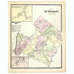
Town of Mt Pleasant. Westchester Co. NY.
Fine lithographed map of the town of Mt Pleasant. The map provides the names of specific homeowners, as well as information about the occupations and physical locations o...
- $100 / ≈ €94
Place & Date: New York, 1867
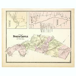
Town of North Castle.
Fine lithographed map of the town of North Castle. The map provides the names of specific homeowners, as well as information about the occupations and physical locations ...
- $100 / ≈ €94
Place & Date: New York, 1867
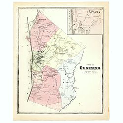
Town of Ossining. Westchester Co. NY.
Fine lithographed map of the town of Ossining. The map provides the names of specific homeowners, as well as information about the occupations and physical locations of t...
- $100 / ≈ €94
Place & Date: New York, 1867
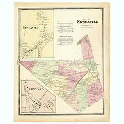
Town of New Castle. Westchester Co. NY.
Fine lithographed map of the town of New Castle. The map provides the names of specific homeowners, as well as information about the occupations and physical locations of...
- $100 / ≈ €94
Place & Date: New York, 1867
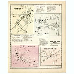
Mount Kisco / Bedford / Katonah / Bedford Station.
Fine lithographed map of Mount Kisco / Bedford / Katonah / Bedford Station. The map provides the names of specific homeowners, as well as information about the occupation...
- $100 / ≈ €94
Place & Date: New York, 1867
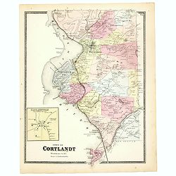
Town of Cortlandt.
Fine lithographed map of the town of Cortlandt. The map provides the names of specific homeowners, as well as information about the occupations and physical locations of ...
- $90 / ≈ €84
Place & Date: New York, 1867
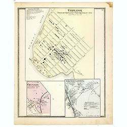
Town of Verplanck / Crugers / Croton Landing.
Fine lithographed map of the town of Verplanck / Crugers / Croton Landing. The map provides the names of specific homeowners, as well as information about the occupations...
- $90 / ≈ €84
Place & Date: New York, 1867
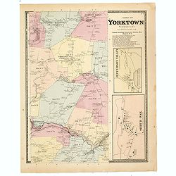
Town of Yorktown.
Fine lithographed map of the town of Yorktown. The map provides the names of specific homeowners, as well as information about the occupations and physical locations of t...
- $90 / ≈ €84
Place & Date: New York, 1867
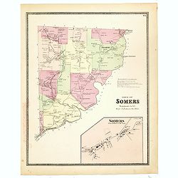
Town of Somers.
Fine lithographed map of the town of Somers. The map provides the names of specific homeowners, as well as information about the occupations and physical locations of the...
- $90 / ≈ €84
Place & Date: New York, 1867
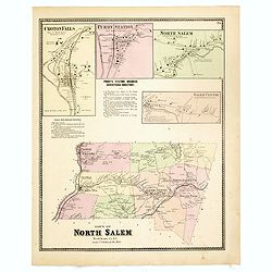
Town of North Salem.
Fine lithographed map of the town of North Salem. The map provides the names of specific homeowners, as well as information about the occupations and physical locations o...
- $90 / ≈ €84
Place & Date: New York, 1867
Property of F.A.Halstead Bedford Station, The Halstead Homestead at Bedford and Inland Vale residence of J.S.Libby, Westchester Co. NY North Salem.
Three heliographic prints on one sheet : "Property of F.A.Halstead Bedford Station", "The Halstead Homestead at Bedford" and "Inland Vale residen...
- $100 / ≈ €94
Place & Date: New York, 1867
Soil map - South Carolina Campobello Sheet.
Early color lithographed soil map by Julius Bien & Co. in New York for the Department of Agriculture. Legends at the side give detail on soil type, etc. They also inc...
- $50 / ≈ €47
Place & Date: New York, 1903
Soil map - Virginia Norfolk Sheet.
Soil map printed by Julius Bien & Co. in New York for the Department of Agriculture. The map gives great detail of the area centered on Norfolk, Potsmouth, Chesapeake...
- $50 / ≈ €47
Place & Date: New York 1903
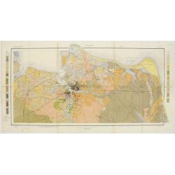
Soil map - Connecticut. - Massachusetts, (Hartford) Springfield sheet.
Early color lithographed soil map by Julius Bien & Co. in New York for Department of Agriculture. Legends at side give detail on soil type, etc. They also include int...
Place & Date: New York, 1903
Selling price: $85
Sold in 2008
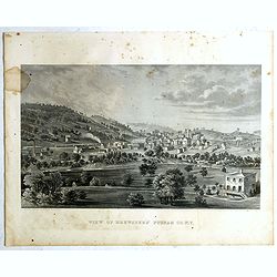
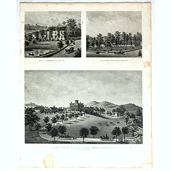
View of Brewsters' Putnam Co.N.Y.
Heliographic print of Brewsters' Putnam Co.N.Y." after a design by R.K.Sneden.From Beer's famous county atlas "Atlas of New York and vicinity, a documentary rec...
- $100 / ≈ €94
Place & Date: New York,1867
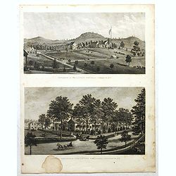
Résidence of WM H.Drew Southeast Putnam Co.N.Y / Lake Farm Résidence of John V.Storm East Fiskill Dutches Co.N.Y.
Two heliographic prints on one sheet : " Résidence of WM H.Drew Southeast Putnam Co.N.Y / Lake Farm Résidence of John V.Storm East Fiskill Dutches Co.N.Y." af...
- $100 / ≈ €94
Place & Date: New York,1867
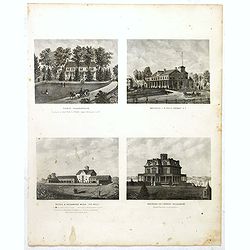
Todd Homestead / Résidence of B. Travis Katonah N.Y / Reisig & HexamersBarn Ivy Hill / Résidence of W.F Bearns
Four heliographic prints on one sheet : "Todd Homestead / Résidence of B. Travis Katonah N.Y / Reisig & HexamersBarn Ivy Hill / Résidence of W.F Bearns "I...
- $100 / ≈ €94
Place & Date: New York,1867
Residence of A.S. Doane Doanesburg Putnam Co. N.Y. - N. L. Thompsons's lake Mahopac - The Gregory House lake Mahopac Putnam Co N. Y. Lewis H. Gregory Proprietor.
Three heliographic prints on one sheet : "Residence of A.S. Doane Doanesburg Putnam Co. N.Y. (120x150mm.) / N. L. Thompsons's lake Mahopac (120 x 160mm.) / The Grego...
- $100 / ≈ €94
Place & Date: New York,1867
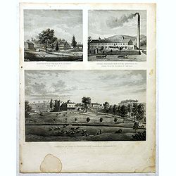
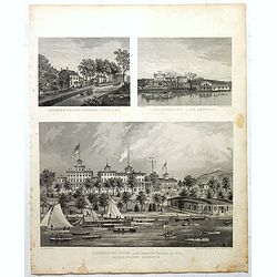
Mount Vernon Valley Residence of S.J. Powers / Borden condensed milk factory brewsters N.Y / Residence of Dan D. Chamberlain South East Putman Co. N.Y.
Three heliographic prints on one sheet : "Mount Vernon Valley Residence of S.J. Powers (135 x 155mm.) / Borden condensed milk factory brewsters N.Y (135 x 155mm.) / ...
- $100 / ≈ €94
Place & Date: New York,1867
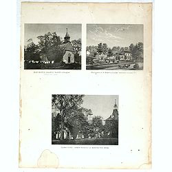
"Old Dutch church, "Sleepy Hollow" / Residence of A.B Baylis esq Bedford village N.Y / "Sunny side" former residence of Washington Irving."
Three heliographic prints on one sheet : "Old Dutch church, "Sleepy Hollow" / Residence of A.B Baylis esq Bedford village N.Y / "Sunny side" form...
- $100 / ≈ €94
Place & Date: New York,1867
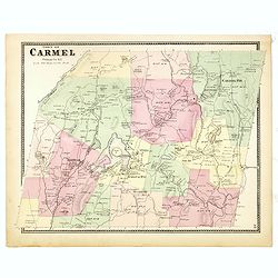
Town of Carmel.
Fine lithographed map of the town of Carmel. From : "Atlas of New York and vicinity" published by Beers, Ellis & Soule, 95 Maiden Lane, New York. The map pr...
Place & Date: New York, 1867
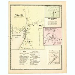
Town of Carmel / Towners Station / South East Centre / Mill Town.
Fine lithographed map of the town of Carmel / Towners Station / South East Centre / Mill Town. From "Atlas of New York and vicinity" published by Beers, Ellis ...
Place & Date: New York, 1867
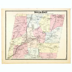
Town of South East.
Fine lithographed map of the town of South East. From : "Atlas of New York and vicinity" published by Beers, Ellis & Soule, 95 Maiden Lane, New York.The map...
Place & Date: New York, 1867
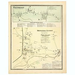
Town of Patterson / Brewsters Station.
Fine lithographed map of the town of Patterson / Brewsters Station. From : "Atlas of New York and vicinity" published by Beers, Ellis & Soule, 95 Maiden Lan...
Place & Date: New York, 1867
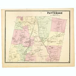
Town of Patterson.
Fine lithographed map of the town of Patterson. From : "Atlas of New York and vicinity" published by Beers, Ellis & Soule, 95 Maiden Lane, New York.The map ...
Place & Date: New York, 1867
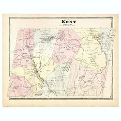
Town of Kent.
Fine lithographed map of the town of Kent. From :"Atlas of New York and vicinity" published by Beers, Ellis & Soule, 95 Maiden Lane, New York.The map provid...
Place & Date: New York, 1867
Soil map - Texas, Nacogdoches sheet.
Early color lithographed soil map by Julius Bien & Co. in New York for Department of Agriculture. Legends at side give detail on soil type, etc. They also include int...
- $75 / ≈ €70
Place & Date: New York, 1903
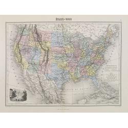
Etats-Unis.
Decorative map of the United States from Géographie Universelle, Atlas Migeon. Oklahoma is Indian Territory with Public Lands in the panhandle. With an engraving lower l...
- $75 / ≈ €70
Place & Date: Paris, 1874
Falls of mount Ida, above the town of Troy.
Decorative print after Jacques Milbert, and lithographed by Bichbois, Showing the Water Falls of mount Ida, above the town of Troy.From Amérique Septentrionale. Printed ...
- $150 / ≈ €140
Place & Date: Paris, 1829
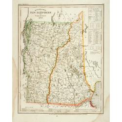
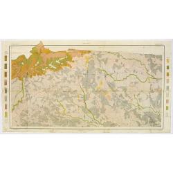
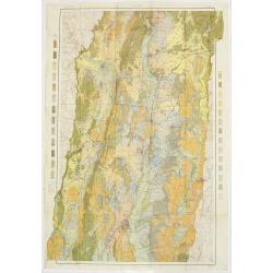
Neueste Karte von New Hampshire und Vermont.
Detailed map of New Hampshire and Vermont with numerous physical and political features including mines, settlements, trails/roads, forts and Indian areas. From Meijers H...
- $150 / ≈ €140
Place & Date: Hildburghausen/ Philadelphia, 1846
![[Native Americans of village at Nootka Sound].](/uploads/cache/44726-250x250.jpg)
[Native Americans of village at Nootka Sound].
Aquatint depicting people in a Nootka Sound village engraved by A.D Rossi, Plate N° 12 From Giulio Ferrario's work Le Costume Ancien et Moderne ou Histoire du gouverneme...
Place & Date: Milan, 1827
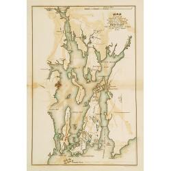
Plan of part of RHODE ISLAND..
Map showing vicinity around New Port. It Shows American and British armies at the siege of Newport and the subsequent action on the 29th of August 1778. Depicting the Fre...
- $100 / ≈ €94
Place & Date: Philadelphia, 1806 or 1834
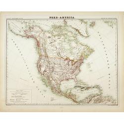
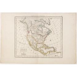
Nord-America
Large and detailed map of North and Central America. With inset key to the different possessions, Republic of Mexico, - Central America, States and territories.Lithograph...
- $150 / ≈ €140
Place & Date: Berlin, 1872
![[No title]. [Alaska-North American village with boats].](/uploads/cache/44728-250x250.jpg)
[No title]. [Alaska-North American village with boats].
Aquatint depicting a fishing scene engraved by Paolo Fumagalli, Plate N° 20 From Giulio Ferrario's work Le Costume Ancien et Moderne ou Histoire du gouvernement, de la m...
Place & Date: Milan, 1827
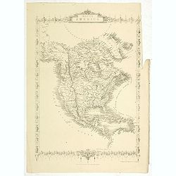
North America.
Map of North America, published by "The London Printing and Publishing Company". Drawn and engraved by John Rapkin.
- $100 / ≈ €94
Place & Date: London, 1854
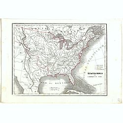
Etats-Unis de l'Amérique du nord.
Detailed map of North America, prepared by Charles V. Monin (fl.1830-1880) a French cartographer of Caen and Paris. Published in Atlas Universel de Géographie Ancienne &...
- $75 / ≈ €70
Place & Date: Paris, 1845
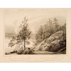
Course of the Hudson and the Millsnear Sandy Hill.
Decorative print after a design of Jacques Milbert, and lithographed by Sabatier, showing the River Hudson with the falls near Sandy Hill.From Amérique Septentrionale. P...
- $150 / ≈ €140
Place & Date: Paris, 1829
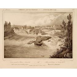
Falls of the Hudson at Sandy Hill.
Decorative print of the Falls on the river Hudson near Sandy Hill, after Jacques Milbert, and lithographed by Bichbois and the figures by Victor Adam.An outstanding view ...
- $150 / ≈ €140
Place & Date: Paris, 1829
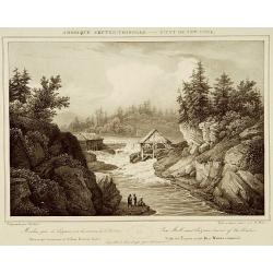
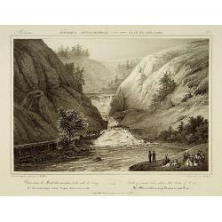
Saw Mill near Luzerne source of the Hudson.
Decorative print of Saw Mill near Lucerne, Warren County, after Jacques Milbert, and lithographed by Bichebois.Printed by de Bove and Noöl ainé &Cie. An outstanding...
- $150 / ≈ €140
Place & Date: Paris 1829
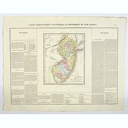
Carte Géographique, Statistique et Historique du New-Jersey.
A detailed map of New Jersey, from Buchon's Atlas Gégraphique Statistique, historique et chronologique des deux Amériques et des isles adjacentes: traduit de l'atlas ex...
Place & Date: Paris, 1825
Selling price: $50
Sold in 2019
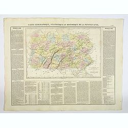
Carte Géographique, Statistique et Historique de la Pensylvanie.
A detailed map of Pennsylvania, from Buchon's Atlas Gégraphique Statistique, historique et chronologique des deux Amériques et des isles adjacentes, traduit de l'atlas ...
- $100 / ≈ €94
Place & Date: Paris, 1825
Carte Geographique, Statistique et Historique du Delaware.
A nice detailed map of Delaware, from Buchon's Atlas Gégraphique Statistique, historique et chronologique des deux Ameriques et des isles adjacentes, traduit de l'atlas ...
- $100 / ≈ €94
Place & Date: Paris, 1825
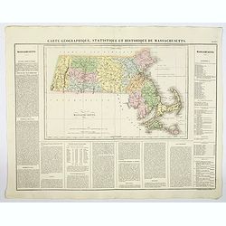
Carte Geographique, Statistique et Historique de Massachusetts.
A detailed map of Massachusetts, from Buchon's Atlas Gégraphique Statistique, historique et chronologique des deux Ameriques et des isles adjacentes, traduit de l'atlas ...
- $100 / ≈ €94
Place & Date: Paris, 1825
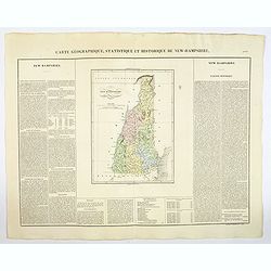
Carte Geographique, Statistique et Historique du New Hampshire.
A detailed map of New Hampshire, from Buchon's Atlas Gégraphique Statistique, historique et chronologique des deux Ameriques et des isles adjacentes, traduit de l'atlas ...
Place & Date: Paris, 1825
Selling price: $50
Sold in 2019
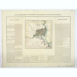
Carte Geographique, Statistique ey Historique du District de Colombie.
A lovely, detailed map of the District of Columbia, (Washington) from Buchon's, Atlas Gégraphique Statistique, historique et chronologique des deux Ameriques et des isle...
- $100 / ≈ €94
Place & Date: Paris, 1825
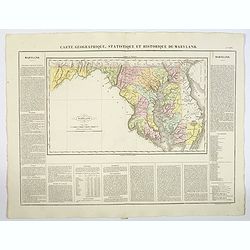
Carte Geographique, Statistique ey Historique du Maryland.
A lovely, detailed map of Maryland, from Buchon's, Atlas Gégraphique Statistique, historique et chronologique des deux Ameriques et des isles adjacentes, traduit de l'at...
- $100 / ≈ €94
Place & Date: Paris, 1825
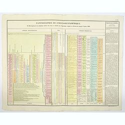
Pantographie de l'Histoire d'Amerique, ou Description de la situation relative des etats et colonies de l'Amerique. . .
An attractivelooking hand colored historical timeline table (in French), charting important historical events and discoveries of America and their States and Colonies sin...
- $100 / ≈ €94
Place & Date: Paris, 1825
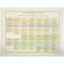
Carte Chronologiquedes Etats-Unis.
A hand colored historical timeline table (in French), highlighting "the main [historical] events in the years from their establishment to the declaration of independ...
- $100 / ≈ €94
Place & Date: Paris, 1825
Amérique du Nord.
Decorative map of Northern America from Géographie Universelle, Atlas Migeon. published by J. Migeon. Nice engraving at the lower left hand of New York with the Statue o...
- $125 / ≈ €117
Place & Date: Paris, 1874
![[American history plate].](/uploads/cache/40176-250x250.jpg)
[American history plate].
Scarce print (150x177mm.) on a German text sheet taken from a first edition of Johann Ludwig Gottfried's "Newe Welt Vnd Americanische Historien/ Jnhaltende Warhaffti...
- $80 / ≈ €75
Place & Date: Frankfurt, M.Merian, 1633
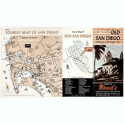
Welcome to old San Diego, birthplace of California 1769.
Publicity leaflet for "Manuel's Restauranté" in the Casa de Pedrorena. On one side a pictorial map of San Diego and "Tourist Map of Old San Diego", w...
- $75 / ≈ €70
Place & Date: San Diego, ca. 1935
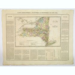
Carte Geographique, Statistique et Historique du New York.
A detailed map of State of New York, from Buchon's Atlas Gégraphique Statistique, historique et chronologique des deux Ameriques et des isles adjacentes, traduit de l'at...
- $100 / ≈ €94
Place & Date: Paris, 1825
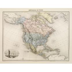
Amérique septentrionale.
A fine map of North America published by the well-known Paris publisher of maps, globes and atlases C.F. Delamarche.
- $110 / ≈ €103
Place & Date: Paris, 1824
![Town of Hudson. . . [title in French, English, German & Latin] N°11. Pl. 3.](/uploads/cache/26653-250x250.jpg)
Town of Hudson. . . [title in French, English, German & Latin] N°11. Pl. 3.
The town of Hudson.From 3e Livraison Amérique Septentrionale - Etat de New York. After Jacques Milbert and lithographed by L. Sabatier, the figures by V. Adam. Printed b...
- $150 / ≈ €140
Place & Date: Paris, Bove dirigée par Nöel ainé & Cie, 1829

Portrait de Benjamin Franklin.
Portrait de Benjamin Franklin. From Giulio Ferrario's work Le Costume ancien et moderne ou histoire du gouvernement, de la milice, de la religion, des arts, etc. publishe...
- $75 / ≈ €70
Place & Date: Milan, 1827
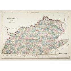
Kentucky.
A detailed lithographed map of Kentucky. Published by Adam (1784-1874) and Charles Black, publishers active in Edinburgh.
- $100 / ≈ €94
Place & Date: Edinburg, 1874
![[Moose].](/uploads/cache/40180-250x250.jpg)
[Moose].
Scarce print (150x177mm.) of a Moose on a German text sheet taken from a first edition of Johann Ludwig Gottfried's "Newe Welt Vnd Americanische Historien/ Jnhaltend...
- $100 / ≈ €94
Place & Date: Frankfurt, M.Merian, 1633