Browse Listings in America > Caribbean & Atlantic Ocean
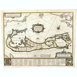
Mappa Aestivarum Insularum, alias Barmudas..
Based closely on Blaeu's map of 1630 but with a simpler centered title piece. The map includes the arms of Bermuda and England, and lists proprietors of the various tribe...
Place & Date: Amsterdam, 1645

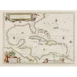
Insulae Americanae in Oceanus Septentrionali cum Terris..
General map of the West Indies extending from Virginia to the mouth of the Orinoco, and destined to be copied in various shapes by many other publishers. Title cartouche ...
Place & Date: Amsterdam, 1647
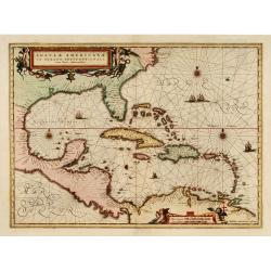
Insulae Americanae in Oceano Septentrionali cum Terris adiacentibus.
General map of the West Indies extending from Virginia to the mouth of the Orinoco, and destined to be copied in various shapes by many other publishers. Title cartouche ...
- $1500 / ≈ €1404
Place & Date: Amsterdam, 1658

Pascaerte van Brazil en Nieu Nederlandt van Cuorvo en Flores.
A rare chart of the Atlantic Ocean from the first edition of Hendrick Doncker's Zee-Atlas, of which no surviving example is known.Although the idea of its unusual coverag...
Place & Date: Amsterdam, 1658

Pascaerte vande Caribische Eylanden, vande Barbados tot aende Bocht van Mexico ‘t Amsterdam By Hendrick Doncker. . .
First state. Rare. “This chart appeared in the first edition of Hendrick Doncker’s Zee-Atlas, of which no surviving example is known” -- Burden. This is an example ...
Place & Date: Amsterdam, 1659
Insulae Americanae in oceano septentrionali..
Showing the Gulf of Mexico and the West Indian Islands, and the adjacent North and South American coastlines.The cartography is based on the rare Gerritz chart of 1631. T...
- $1750 / ≈ €1638
Place & Date: Amsterdam, 1660

Mappa Aestivarum Insularum alias Barmudas.
Blaeu based his work on John Speed's remarkably accurate map of 1626-1627. It shows the island divided into tribes and lots, and below the map itself appear the names of ...
- $2200 / ≈ €2059
Place & Date: Amsterdam, 1662

Canibales Insulae.
Rare, early Dutch nautical chart of the Caribbean from Puerto Rico southward.
Place & Date: Amsterdam, 1670

Pascaerte vande Vlaemsche, Soute, en Caribesche Eylanden, als mede Terra Nova,. . .
This fine and scarce sea chart covers the central Atlantic and extends to include the Maritime Provinces, Antilles and the northwest coast of South America, east to the A...
Place & Date: Amsterdam, 1672

Recueil de divers voyages faits en Afrique et en l'Amerique, qui n'ont point esté encore publiez.
First edition of this collection of significant and interesting voyages, edited by a scholar and book collector who served in the employ of Louis XIV before being appoint...
Place & Date: Paris, Louis Billaine, 1674