Browse Listings in America > Caribbean & Atlantic Ocean

Occidentalis Americae partis.
The most beautifully engraved early map of the Caribbean, including Florida and the Southeast. The map includes representations of Columbus' ships and various notes regar...
Place & Date: Frankfurt, 1594

(Island of Pearls) Perlarum insula ob unionum copiam sic dicta.
A depiction of Cubagua as the Perlarum Insula (Island of Pearls), with in the foreground, two large ships send dinghies toward busy Native Americans collecting pearl oyst...
- $250 / ≈ €234
Place & Date: Frankfurt, 1594
![Pisces in mari alati [flying fish attack]](/uploads/cache/48527-250x250.jpg)
Pisces in mari alati [flying fish attack]
Flying fish attacking a Portuguese ship in the West Indian Waters.Read more about "Les Grand Voyages" by Theodore De Bry [+]
- $400 / ≈ €374
Place & Date: Frankfurt, 1594
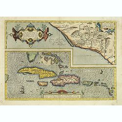
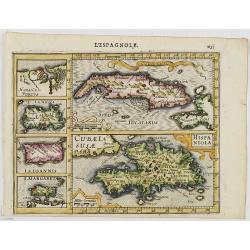
Culiacanae Americae regionis.. / Hispaniolae, Cubae..
Two separate virtually identically sized inset maps on one sheet, each with a decorative scroll title cartouche. Culiacanae depicts the coastal and inland western region...
- $1200 / ≈ €1123
Place & Date: Antwerp 1598
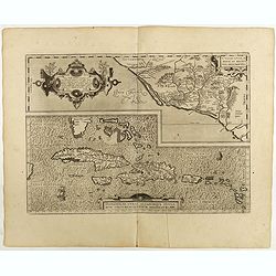
Culiacanae Americae regionis.. / Hispaniolae, Cubae..
Two virtually identically sized inset maps on one sheet, each with a decorative scroll title cartouche. Culiacanae depicts the coastal and inland western region in North ...
Place & Date: Antwerp, 1598
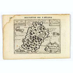
Sancta Helena.
An attractive small map of the south Atlantic island of St. Helena. Two years after the publication of Linschoten's Itinerario, the first map of St. Helena appeared in 15...
- $100 / ≈ €94
Place & Date: Amsterdam, 1606
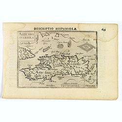
Decriptio Hispaniolae.
A miniature map of Hispaniola, (modern day Haiti and Dominican Republic), as well as the extreme eastern parts of Cuba. With a simple strap-work title and a scale in Germ...
- $150 / ≈ €140
Place & Date: Amsterdam, 1606
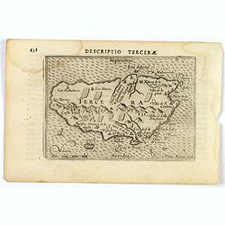
Descriptio Tercerae.
An attractive miniature map of The Azorian island of Terceira, in the Atlantic Ocean. Published by Petrus Bertius, in Amsterdam at the turn of the seventeenth century. Di...
- $100 / ≈ €94
Place & Date: Amsterdam, 1606
Cuba Insula. Hispaniola.
Decorative engraved map of Cuba above Hispaniola with smaller insets of Havana, Jamaica, Puerto Rico and Margarita.From the first French-text edition of Jodocus Hondius''...
- $300 / ≈ €281
Place & Date: Amsterdam, 1608
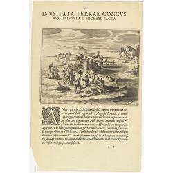
V. Inusitata Terrae Concussio, in Insula S. Michael Facta.
Showing the Vila Franca earthquake on 26 July 1591Theodore de Bry, a German engraver and book dealer, began a compilation of early voyages in 1590 and had published six p...
- $75 / ≈ €70
Place & Date: Frankfurt, 1609
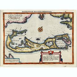
Description des Isles Bermudas.
Map of Bermuda from the rare Cloppenburg edition slightly larger format and more scarce edition of the Mercator/Hondius "Atlas Minor". Engraved by Pieter Van De...
- $800 / ≈ €749
Place & Date: Amsterdam, 1630
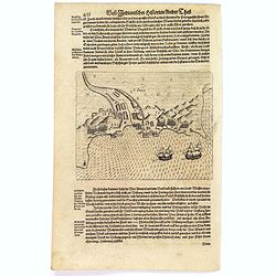
![[English attack Praia.]](/uploads/cache/39900-250x250.jpg)
[English attack Praia.]
Scarce print with German text sheet showing the English attack on Praia. On 16 November, 1585, during Francis Drake’s round-the-world voyage, his fleet anchored off San...
- $150 / ≈ €140
Place & Date: Frankfurt, M.Merian, 1633
![[Black slaves escape punishment].](/uploads/cache/39920-250x250.jpg)
[Black slaves escape punishment].
Scarce print with a German text sheet. Many Black slaves, weary of ill treatment, managed to escape Spanish captivity and freely wandered the island, breaking into prison...
- $80 / ≈ €75
Place & Date: Frankfurt, M.Merian, 1633
S. Jago.
Scarce print with German text sheet showing the Dutch at Santiago. The Dutch were invited to visit the harbour, about two miles along the coast. On arrival, they found it...
- $100 / ≈ €94
Place & Date: Frankfurt, M.Merian, 1633
![[Religious ritual on Hispaniola].](/uploads/cache/39921-250x250.jpg)
[Religious ritual on Hispaniola].
Scarce print with a German text sheet.On certain feast-days the Indian cacique, while beating a drum, led a procession of his people to the worship of their idol, which w...
- $80 / ≈ €75
Place & Date: Frankfurt, M.Merian, 1633
![[Captain Weert dines with the Chief].](/uploads/cache/39922-250x250.jpg)
[Captain Weert dines with the Chief].
Scarce print with a German text sheet. Captain Weert and the chief ate modestly on roast plantain, smoked fish and wine fermented from palm, bought by a local woman. Howe...
- $80 / ≈ €75
Place & Date: Frankfurt, M.Merian, 1633
![[Dutch attack the fortress of Praia.]](/uploads/cache/39901-250x250.jpg)
[Dutch attack the fortress of Praia.]
Scarce print with German text sheet showing the Dutch attack on Praia.On 27th June 1589, Simon de Cordes left Holland with five ships, bound for the Magellan Straits. On ...
- $80 / ≈ €75
Place & Date: Frankfurt, M.Merian, 1633
![[Mutiny in Jamaica.]](/uploads/cache/40475-250x250.jpg)
[Mutiny in Jamaica.]
On 29th May 1504, Columbus entered St. Ann’s Bay, Jamaica, but the Porras brothers and a number of Spanish soldiers on the island prevented him from coming ashore and t...
Place & Date: Frankfurt, M.Merian, 1633
![[Columbus lands on the Island of San Salvador.]](/uploads/cache/40479-250x250.jpg)
[Columbus lands on the Island of San Salvador.]
On 12th October 1492, after 33 days at sea, Columbus sighted land. His three ships made their way round the south-west point of an island Columbus named San Salvador - be...
- $100 / ≈ €94
Place & Date: Frankfurt, M.Merian, 1633
![[Collective suicide under Spanish rule.]](/uploads/cache/40480-250x250.jpg)
[Collective suicide under Spanish rule.]
The natives of Hispaniola, who saw no end to the fearful oppression of Spanish rule, preferred death. So many, devoid of all hope, went into the woods to kill their child...
- $80 / ≈ €75
Place & Date: Frankfurt, M.Merian, 1633
![[Vespucci lands on the Island of Itius.]](/uploads/cache/40486-250x250.jpg)
[Vespucci lands on the Island of Itius.]
According to the esteemed historian, Las Casas,‘Itius cannot be other than the islands we reach coming from Spain, named Guadeloupe and Dominica.When Vespucci and his S...
Place & Date: Frankfurt, M.Merian, 1633

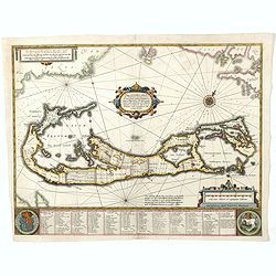
Mappa Aestivarum Insularum alias Barmudas.
Blaeu based his work on John Speed's remarkably accurate map of 1626-1627. It shows the island divided into tribes and lots, and below the map itself appear the names of ...
Place & Date: Amsterdam, 1635
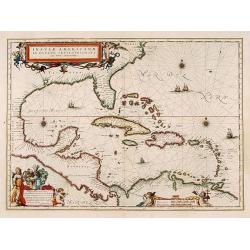
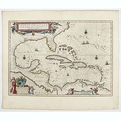
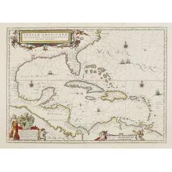
Insulae Americanae in Oceano Septentrionali cum Terris adiacentibus.
General map of the West Indies extending from Virginia to the mouth of the Orinoco, and destined to be copied in various shapes by many other publishers. Title cartouche ...
- $1000 / ≈ €936
Place & Date: Amsterdam, 1635
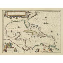
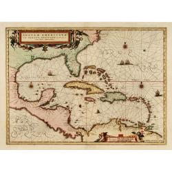
Insulae Americanae in Oceano Septentrionali cum Terris adiacentibus.
General map of the West Indies extending from Virginia to the mouth of the Orinoco, and destined to be copied in various shapes by many other publishers.Title cartouche t...
- $1800 / ≈ €1684
Place & Date: Amsterdam, 1638
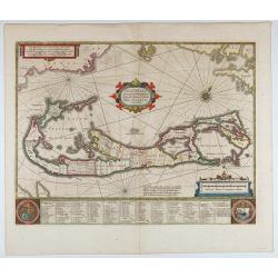
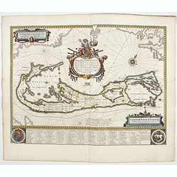
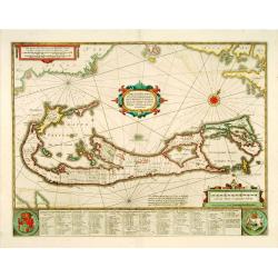
Mappa Aestivarum Insularum, alias Barmudas..
This magnificent map is based on the famous survey by John Norwood of the Bermuda Company in 1618. The map shows the division into the original Tribes and shows the vario...
- $2000 / ≈ €1871
Place & Date: Amsterdam, 1640
Mappa Aestivarum Insularum alias Barmudas.
Blaeu based his work on John Speed's remarkably accurate map of 1626-1627. It shows the island divided into tribes and lots, and below the map itself appear the names of ...
- $2000 / ≈ €1871
Place & Date: Amsterdam, 1644
Insulae Americanae in Oceanus Septentrionali cum Terris..
General map of the West Indies extending from Virginia to the mouth of the Orinoco, and destined to be copied in various shapes by many other publishers.Title cartouche t...
- $2500 / ≈ €2339
Place & Date: Amsterdam, 1644
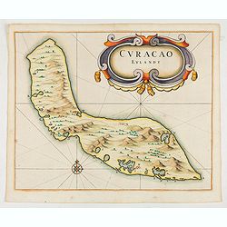
Curacao Eylandt.
One of the earliest separate maps of Curaçao. The map has nice topographical detail and features an ornate title cartouche. Published in de Laet's account of the history...
Place & Date: Amsterdam, 1644
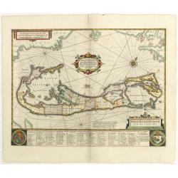
Mappa Aestivarum Insularum, alias Barmudas.
This magnificent map is based on the famous survey by John Norwood of the Bermuda Company in 1618. The map shows the division into the original Tribes and shows the vario...
- $2000 / ≈ €1871
Place & Date: Amsterdam, 1645
Mappa Aestivarum Insularum, alias Barmudas. . .
It shows the island divided into tribes and lots, and below the map itself appear the coats of arms of Bermuda and England and the names of the first proprietors and the ...
- $2000 / ≈ €1871
Place & Date: Amsterdam, 1645
Mappa Aestivarum Insularum, alias Barmudas..
Based closely on Blaeu's map of 1630 but with a simpler centered title piece. The map includes the arms of Bermuda and England, and lists proprietors of the various tribe...
Place & Date: Amsterdam, 1645

Insulae Americanae in Oceanus Septentrionali cum Terris..
General map of the West Indies extending from Virginia to the mouth of the Orinoco, and destined to be copied in various shapes by many other publishers. Title cartouche ...
Place & Date: Amsterdam, 1647
Insulae Americanae in Oceano Septentrionali cum Terris adiacentibus.
General map of the West Indies extending from Virginia to the mouth of the Orinoco, and destined to be copied in various shapes by many other publishers. Title cartouche ...
- $1500 / ≈ €1404
Place & Date: Amsterdam, 1658

Pascaerte van Brazil en Nieu Nederlandt van Cuorvo en Flores.
A rare chart of the Atlantic Ocean from the first edition of Hendrick Doncker's Zee-Atlas, of which no surviving example is known.Although the idea of its unusual coverag...
Place & Date: Amsterdam, 1658

Pascaerte vande Caribische Eylanden, vande Barbados tot aende Bocht van Mexico ‘t Amsterdam By Hendrick Doncker. . .
First state. Rare. “This chart appeared in the first edition of Hendrick Doncker’s Zee-Atlas, of which no surviving example is known” -- Burden. This is an example ...
Place & Date: Amsterdam, 1659
Insulae Americanae in oceano septentrionali..
Showing the Gulf of Mexico and the West Indian Islands, and the adjacent North and South American coastlines.The cartography is based on the rare Gerritz chart of 1631. T...
- $1000 / ≈ €936
Place & Date: Amsterdam, 1660

Mappa Aestivarum Insularum alias Barmudas.
Blaeu based his work on John Speed's remarkably accurate map of 1626-1627. It shows the island divided into tribes and lots, and below the map itself appear the names of ...
- $2200 / ≈ €2059
Place & Date: Amsterdam, 1662

Canibales Insulae.
Rare, early Dutch nautical chart of the Caribbean from Puerto Rico southward.
Place & Date: Amsterdam, 1670

Pascaerte vande Vlaemsche, Soute, en Caribesche Eylanden, als mede Terra Nova,. . .
This fine and scarce sea chart covers the central Atlantic and extends to include the Maritime Provinces, Antilles and the northwest coast of South America, east to the A...
Place & Date: Amsterdam, 1672

Recueil de divers voyages faits en Afrique et en l'Amerique, qui n'ont point esté encore publiez.
First edition of this collection of significant and interesting voyages, edited by a scholar and book collector who served in the employ of Louis XIV before being appoint...
Place & Date: Paris, Louis Billaine, 1674