Browse Listings in America > Caribbean & Atlantic Ocean

Occidentalis Americae partis.
The most beautifully engraved early map of the Caribbean, including Florida and the Southeast. The map includes representations of Columbus' ships and various notes regar...
Place & Date: Frankfurt, 1594
![Pisces in mari alati [flying fish attack]](/uploads/cache/48527-250x250.jpg)
Pisces in mari alati [flying fish attack]
Flying fish attacking a Portuguese ship in the West Indian Waters.Read more about "Les Grand Voyages" by Theodore De Bry [+]
- $400 / ≈ €374
Place & Date: Frankfurt, 1594

(Island of Pearls) Perlarum insula ob unionum copiam sic dicta.
A depiction of Cubagua as the Perlarum Insula (Island of Pearls), with in the foreground, two large ships send dinghies toward busy Native Americans collecting pearl oyst...
- $250 / ≈ €234
Place & Date: Frankfurt, 1594
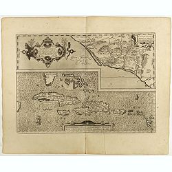
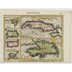
Culiacanae Americae regionis.. / Hispaniolae, Cubae..
Two virtually identically sized inset maps on one sheet, each with a decorative scroll title cartouche. Culiacanae depicts the coastal and inland western region in North ...
Place & Date: Antwerp, 1598
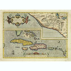
Culiacanae Americae regionis.. / Hispaniolae, Cubae..
Two separate virtually identically sized inset maps on one sheet, each with a decorative scroll title cartouche. Culiacanae depicts the coastal and inland western region...
- $1200 / ≈ €1123
Place & Date: Antwerp 1598
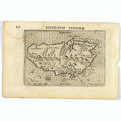
Descriptio Tercerae.
An attractive miniature map of The Azorian island of Terceira, in the Atlantic Ocean. Published by Petrus Bertius, in Amsterdam at the turn of the seventeenth century. Di...
- $100 / ≈ €94
Place & Date: Amsterdam, 1606
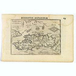
Decriptio Hispaniolae.
A miniature map of Hispaniola, (modern day Haiti and Dominican Republic), as well as the extreme eastern parts of Cuba. With a simple strap-work title and a scale in Germ...
- $150 / ≈ €140
Place & Date: Amsterdam, 1606
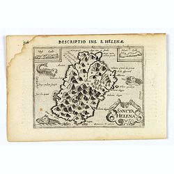
Sancta Helena.
An attractive small map of the south Atlantic island of St. Helena. Two years after the publication of Linschoten's Itinerario, the first map of St. Helena appeared in 15...
- $100 / ≈ €94
Place & Date: Amsterdam, 1606
Cuba Insula. Hispaniola.
Decorative engraved map of Cuba above Hispaniola with smaller insets of Havana, Jamaica, Puerto Rico and Margarita.From the first French-text edition of Jodocus Hondius''...
- $300 / ≈ €281
Place & Date: Amsterdam, 1608
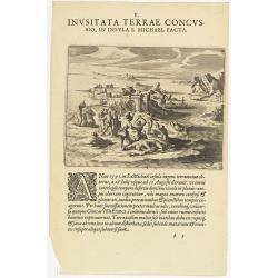
V. Inusitata Terrae Concussio, in Insula S. Michael Facta.
Showing the Vila Franca earthquake on 26 July 1591Theodore de Bry, a German engraver and book dealer, began a compilation of early voyages in 1590 and had published six p...
- $75 / ≈ €70
Place & Date: Frankfurt, 1609