Browse Listings in Africa
![[Lot of 25 leaves of Africa and Egypt]](/uploads/cache/48275-250x250.jpg)
[Lot of 25 leaves of Africa and Egypt]
Twenty-five text leaves with wood block illustrations relating to Africa and Egypt illustrated with maps, animals, plants.... From the 1552 Latin text edition of Münster...
- $100 / ≈ €94
Place & Date: Basel, 1552
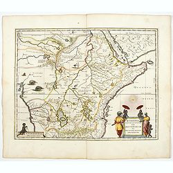
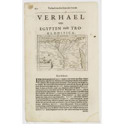
Aethiopia Superior vel Interior vulgo Abissinorum.
An attractive map of the Eastern African and the fictitious kingdom of Prester John. The map shows a major section of central and eastern Africa including Mozambique nort...
- $900 / ≈ €842
Place & Date: Amsterdam, 1644
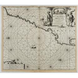
Paskaart van de Kuste van, Gualate en Arguyn. Beginnende van C. Bajador tot C. Blanco. . .
A nautical showing the northwestern coast of Africa, along Western Sahara from Cape Bojador to Cape Blanc. Ornate title cartouche in top right corner shows two main figur...
Place & Date: Amsterdam, ca.1682
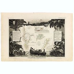
Colonies Françaises (en Afrique). N°91.
Handsome map divided into two sections shows a section of the coast of French West Africa titled 'Senegambie' (Senegal & Gambia) with a drawing of the Senegal River a...
Place & Date: Paris, A. Combette, 1852
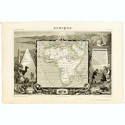
Afrique.
A decorative 19th century map of the continent colored to show the colonial possessions and major tribal kingdoms. The interior is mostly void of detail. The map is surro...
Place & Date: Paris, 1850
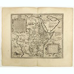
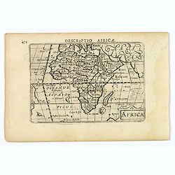
Presbiteri Johannis, sive Abissinorum Imperii descriptio.
Depicting Africa from the Mediterranean to the Mountains of the Moon placed just below Mozambique. Dare to go in Black. All early maps were printed in black and white,...
Place & Date: Antwerp, 1598
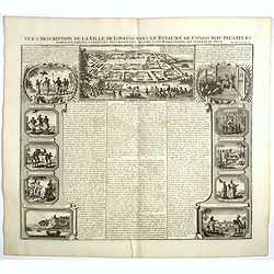
Vue et description de la Ville de Lovango dans le Royaume du Congo. . .
On top a large view of the fabled city of Lovango, text surrounded by ten vignettes of the people and ceremonies of the Kingdom of Congo.Zacharie Chatelain (d.1723) was t...
Place & Date: Amsterdam, 1720
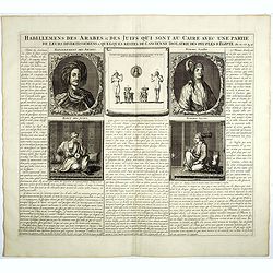
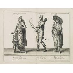
Habillemens Des Arabes & Des Juifs qui sont au Caire avec une partie de leurs divertissements & quelques restes de L'Ancien Idolatrie des peuples D'Egipte.
Decorative set of images the costumes of the Arab and Jewish inhabitants of Cairo, with French text, from Chatelain's monumental 7 volume Atlas Historique. Henri Abraham ...
Place & Date: Amsterdam, 1728
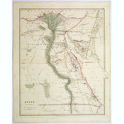
Egypt.
Quite a striking, large steel engraved map of Egypt. Following the course of the River Nile from Lower Egypt southwards to Upper Egypt, then crossing the border with Nubi...
Place & Date: London, 1839
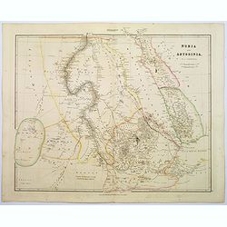
Nubia & Abyssinia.
A lovely looking steel engraved map of the portion of Africa that lies to the west of the Red sea. Mostly great deserts and the territories of nomadic African tribes are ...
Place & Date: London, 1839
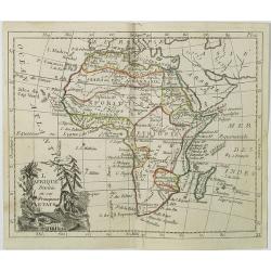
L'Afrique Divisée en ses Principaux Etats.
Map of Africa, from Atlas de la Géographie de toutes les parties du monde.. Ouvrage destiné pour l'education, et nécessaire aux négocians, aux voyageurs, aux fonction...
Place & Date: Paris, Prudhomme, Levrault, Debray, 1806
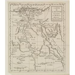
Carte de l'Egypte Ancienne et Moderne..
Map of Egypt illustrating part of the course of the river Nile. From Atlas de la Géographie de toutes les parties du monde .. Ouvrage destiné pour l'education, et néce...
Place & Date: Paris, Prudhomme, Levrault, Debray, 1806
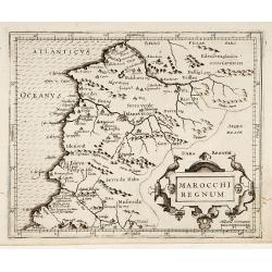
Marocchi Regnum.
From the Mercator/Hondius Atlas Minor. Early map of Morocco.
Place & Date: Amsterdam, 1645
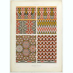
Arabesques. - Mosaïques Murales.
Lithographed by Daumont. From the author's "L'Art Arabe d'après les monuments du Kaire…". Emile Prisse d'Avennes, Orientalist and Muslim convert, obsessive i...
Place & Date: Paris, 1877
Africa.
A lovely miniature map of the continent of Africa, published by Petrus Bertius, in Amsterdam at the beginning of the seventeenth century. There is a small strap-work titl...
Place & Date: Amsterdam, 1606
Femina indica Orientalis - Indus Africanus - Singava vulgo dicta sive erratica femina Ori.
Beautiful engraving by Abraham de Bruyn showing inhabitants of Asian and African people with captions in Latin, French and German.Abraham de Bruyn, a Flemish engraver and...
Place & Date: Cologne, c.1577

Pas-Caart van Guinea en den Custen daer aen gelegen Van C..
A decorative chart of the southwest coast of Africa, embellished with an elaborate, finely colored title-cartouche, and 2 compass-roses. Pieter Goos (ca. 1616-1675) was o...
Place & Date: Amsterdam, 1666
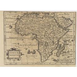
Africae Descriptio.
Map of Africa from the first French-text edition of Jodocus Hondius' Atlas Minor.Shortly after the publication of the big folio-atlases the need was apparently felt for a...
Place & Date: Amsterdam, 1608
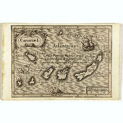
Canariae I.
Small map of the Canary Island. Nicolaes de Clerck (de Klerc) was active as engraver and publisher in Delft from 1599-1621.Included in the rare book : Wereld Spiegel, wae...
Place & Date: Amsterdam, Cloppenburch, 1621
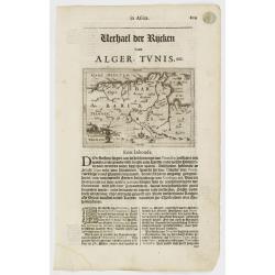
Tunetanum Regnum.
Small map representing Tunisia and Algeria, surrounded by text in Dutch.Nicolaes de Clerck (de Klerc) was active as engraver and publisher in Delft from 1599-1621.Include...
Place & Date: Amsterdam, Cloppenburch, 1621
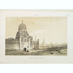
Tombeau du Soultan Tarabey. (XVIe. siècle)
Highly decorative lithography by Ch. Fichot, representing Sultan Tarabey's mausoleum. From the author's "L'Art Arabe d'après les monuments du Kaire?". Emile Pr...
Place & Date: Paris, 1877

Paskaart van de kust van Maroca beginnende van Larache tot aan C. Cantin. . .
A nautical sea chart of the coast of Morocco. Insert at top right: 'Nieuwe Afbeelding van de Rivier Rio Rebata in 't Groot".Bottom right: chart number '32'. Compass ...
Place & Date: Amsterdam, ca.1682
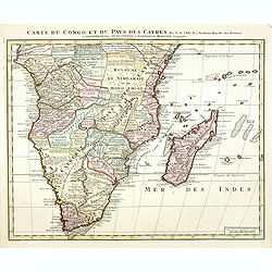
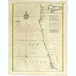
Carte du Congo et du Pays des Cafres. . .
Detailed copper-engraved map of southern Africa providing numerous particulars and comments concerning European trade, native kingdoms, and mineral wealth. Includes Madag...
Place & Date: Amsterdam, c. 1730
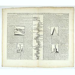
Description du Nil, de ses sources, de son cours depuis les cataractes jusques le Caire . . .
Detailed map of the course of the Nile, from the cataracts of the Nile at the south (top of the image) to Caïro and Giza. At the right, one of the Pyramids is shown (140...
Place & Date: Amsterdam, 1728
Costes de L'Afrique .. ..Cap de Bone Esperance..
In the upper right-hand corner inset map of Saldanha Bay. Numerous place names, soundings and sand banks are shown round the island and the regions are defined by origina...
- $500 / ≈ €468
Place & Date: Amsterdam, 1720

Carte Particuliere d'une Partie d'Asie ou sont Les Isles D'Andemaon, Ceylan, Les Madives . . .
An impressive large sheet chart including the Red Sea, the coasts of Somali, Yemen, east coast of the Arabian peninsula. One of the early maps to focus on this area. Nume...
- $1000 / ≈ €936
Place & Date: Amsterdam, 1720
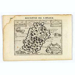
Sancta Helena.
An attractive small map of the south Atlantic island of St. Helena. Two years after the publication of Linschoten's Itinerario, the first map of St. Helena appeared in 15...
- $100 / ≈ €94
Place & Date: Amsterdam, 1606
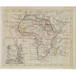
L'Afrique . . .
Map of the African continent, from Atlas moderne portatif composé de vingt-huit cartes sur toutes les parties du globe terrestre .. A l'usage des Colléges, des Pensions...
- $200 / ≈ €187
Place & Date: Paris, Prudhomme, Levrault, Debray, 1806
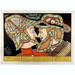
Boer-en Rooinekspel.
Design by E.G.Schlette. This is a board game similar to the famous "snakes and lessons". The game takes the players through various historical battles. Success ...
- $600 / ≈ €561
Place & Date: Amsterdam, Koster, ca. 1890
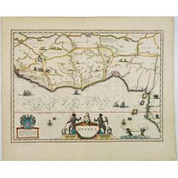
Guinea.
An attractive map covered with intersecting rhumb lines and decorated with monkeys, lions, elephants and native figures. With a dedication to Dr. Nicolas Tulp.
- $750 / ≈ €702
Place & Date: Amsterdam, 1640
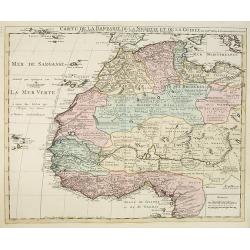
Carte de la Barbarie de la Nigritie et de la Guinée..
Richly engraved map of North and West Africa, based upon the earlier maps of De L'Isle. Richly annotated throughout and with excellent regional detail. It includes the Ca...
- $350 / ≈ €328
Place & Date: Amsterdam c. 1745
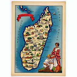
Madagascar.
Very decorative, informative map of Madagascar. The map is filled with buildings, animals, figures and two locals in their typical dress.In lower left corner "Imprim...
- $90 / ≈ €84
Place & Date: France, 1943
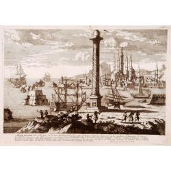
Alexandrie Ville d'Egipte sur la mer Méditeranée..
A very RARE panoramic view of the city of Alexandria, including a legend in the lower part. The plate is numbered in brown pencil in the upper right corner.Engraved by Pi...
- $100 / ≈ €94
Place & Date: Paris, c. 1690
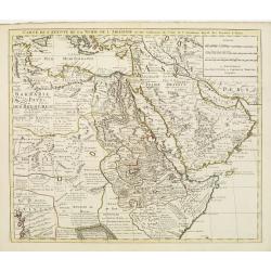
Carte de l'Egypte de la Nubie de L'Abissinie &c..
Detailed copper-engraved map of North-East Africa showing Guinea in the southwest through Ethiopia , the Red Sea to the Persian Gulf.In the northwest, Tunis through Egypt...
- $500 / ≈ €468
Place & Date: Amsterdam, c. 1745
![[2 sheets] Carte particuliere de la Cote Occidentale de l'Afrique...](/uploads/cache/42917-250x250.jpg)
[2 sheets] Carte particuliere de la Cote Occidentale de l'Afrique...
A large 2 sheet map of a part of the west coast of Africa that covers The Gambia and Senegal. (When joined the map would measure approx. 1010 x 1400 mm) D'anville's maps ...
- $400 / ≈ €374
Place & Date: Paris, ca. 1751

Cimbebas et Caffariae Littora a Catenbela ad Promontorium. . .
The coast of Angola, South-West Africa and South Africa up to Port Elizabeth. Classic sea chart of Dutch school with excellent baroque embellishment. North oriented to th...
- $750 / ≈ €702
Place & Date: Amsterdam, 1675
Aegyptus.
A small map focused on the Nile Delta, where the Nile divides into several branches.Included in the rare book : Wereld Spiegel, waer in vertoontword de Beschryvinge der R...
- $100 / ≈ €94
Place & Date: Amsterdam, Cloppenburch, 1621
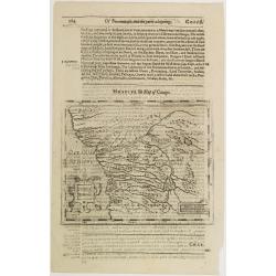
Congi regnu.
Samuel Purchas' edition of the Mercator/Hondius Atlas Minor . Early map of Congo published in his famous collection of voyages His Pilgrimes . With descriptive text in En...
- $100 / ≈ €94
Place & Date: London, 1645
![[71] Barbarie.](/uploads/cache/12843-250x250.jpg)
[71] Barbarie.
Charming chart of the harbour of the province of Barbarie in Syria. Showing town and harbour plan, with soundings, anchorages, rocks, shoals, fortifications and lighthous...
- $50 / ≈ €47
Place & Date: Marseille 1764
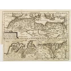
BARBARIE.
An uncommon and delightful map of Northern Africa extends from today's territory of Morocco as far as the Red Sea.With Inset maps of the Nile Delta and the Gulf of Tunis.
- $100 / ≈ €94
Place & Date: Amsterdam, 1700