Browse Listings in Africa
![Carthage, etc. [Foliu XL ]](/uploads/cache/26122-250x250.jpg)
Carthage, etc. [Foliu XL ]
VERSO: Portraits of scholars, and an imaginary view on Carthage in Tunisia (12x17cm.) Page from the famous Liber chronicarum of Hartmann-Schedel 1493, the first and Latin...
Place & Date: Nuremberg 12 July 1493

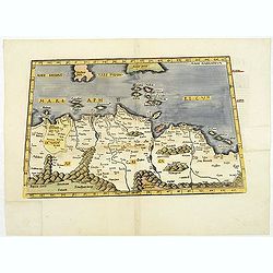
Tabula Prima Africa.
The map apart from depicting Morocco also shows southern Spain and the Balearic Islands. In north Africa the map extends eastwards toward modern day Algeria and to the we...
Place & Date: Strasbourg, 1513

.Tabu nova partis Aphri.
Based on Waldseemüller's map. The maps show Northern Africa as it was known to Europeans at the first part of the 16th century. There is great details across north Afric...
Place & Date: Lyons, M. Servetus, 1535
![Tabula IIII Aphricae. [with Prester John]](/uploads/cache/42945-250x250.jpg)
Tabula IIII Aphricae. [with Prester John]
Early Ptolemaic woodcut map of the regions of Africa that were known to the ancients. The twin lake sources of the Nile are located near the Mons Lune (Mountains of the M...
- $950 / ≈ €889
Place & Date: Vienna, 1522- 1535
.Aphricae Tabula secunda continet.
An important early map of the northern coast of Africa and including parts of the islands of Sicily and Sardine.
Place & Date: Vienne, 1541
Tabula Africae IIII.
Gastaldi's map of the Northern Africa, based on Ptolemy. Showing all of the Mediterranean, Ethiopian Interior, the Red Sea, Egypt, the source of the Nile, Red Sea, Dead S...
- $400 / ≈ €374
Place & Date: Venice, 1548
![[Lot of 25 leaves of Africa and Egypt]](/uploads/cache/48275-250x250.jpg)
[Lot of 25 leaves of Africa and Egypt]
Twenty-five text leaves with wood block illustrations relating to Africa and Egypt illustrated with maps, animals, plants.... From the 1552 Latin text edition of Münster...
- $100 / ≈ €94
Place & Date: Basel, 1552
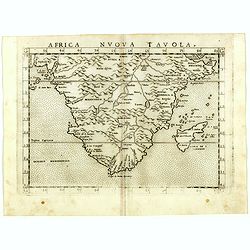
Africa nuova tavola.
Uncommon first edition of this early map of South Africa. Madagascar is called Isola de S. Lorenzo and is oddly shaped.The origin of the Nile conforms to the Ptolemaic co...
- $550 / ≈ €515
Place & Date: Venice, Vincenzo Valgrisi, 1561
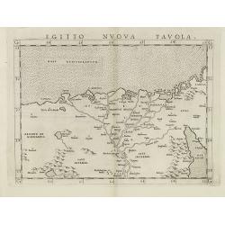
Egitto nuova tavola.
Fine early map of Egypt and the Nile delta. Extends east to the Upper Red Sea and West to "Deserto De Marmarica". Nice detail in the lower Nile regions. Page ta...
- $200 / ≈ €187
Place & Date: Venice, 1561
![[West Africa]](/uploads/cache/46529-250x250.jpg)
[West Africa]
Second block. West Africa, from the Tropic of Cancer south to St Thomas. The interior is filled with lions, elephants, monkeys and camels, with a fenced native village. O...
Place & Date: Venice, 1563
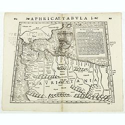
Aphricae Tabula I. (Mauritania - present-day Morocco, Algeria, and Tunisia.)
Double-page woodcut Ptolemaic-style map by Sebastian Münster figuring Mauritania, present-day Morocco, Algeria, and Tunisia, published in the edition of Strabo by Henri ...
Place & Date: Basle, Henri Petri, 1571
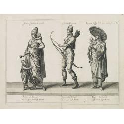
Femina indica Orientalis - Indus Africanus - Singava vulgo dicta sive erratica femina Ori.
Beautiful engraving by Abraham de Bruyn showing inhabitants of Asian and African people with captions in Latin, French and German.Abraham de Bruyn, a Flemish engraver and...
Place & Date: Cologne, c.1577
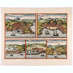
Tingis, Lusitanis, Tangiara. / Tzaffin. / Septa. / Arzilla/ Sala.
Views of the five northern and western African coastal town-view on one sheet: Latin text.From the greatest publication in this genre!. The Civitates was compiled and wri...
- $600 / ≈ €561
Place & Date: Cologne, 1580
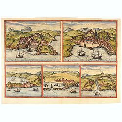
Tingis, Lusitanis, Tangiara. / Tzaffin. / Septa. / Arzilla/ Sala.
Views of the five northern and western African coastal town-view on one sheet: Latin text.From the greatest publication in this genre!. The Civitates was compiled and wri...
- $600 / ≈ €561
Place & Date: Cologne, 1580
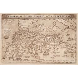
Barbariae et Biledulgerid, nova descriptio.
North-West Africa. Koeman speculated: In view of the important trading relationship between Antwerp and Africa, it is not impossible that the original was a manuscript ma...
- $300 / ≈ €281
Place & Date: Antwerp, 1587

Natoliae.. Aegypti recentior.. Carthaginis ( 3 maps on 1 sheet)
Three maps on one sheet. Map to the left east to the top. Detailed map Turkey, including Cyprus and Crete. Also map of the Nile delta and another map of Tunis. From "...
- $750 / ≈ €702
Place & Date: Antwerp, 1587
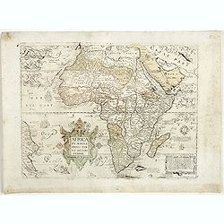
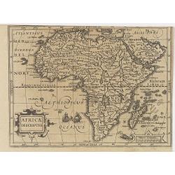
Africa ex magnae Orbis Terrae Descriptione.
Very rare separately published "Lafreri" map of Africa. The title in typical Italian scrollwork surmounted by two Cupids in the lower Atlantic. A dedication to ...
- $6000 / ≈ €5614
Place & Date: Venice, ca. 1590
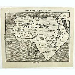
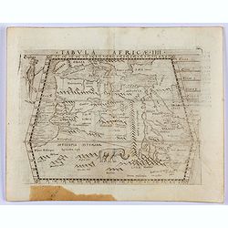
Africa Tertia pars Terrae.
This map of Africa has an unusual shape, tapering to a narrow angle in the south. Numerous rivers appear in West Africa and as tributaries to the Nile, and mountain chain...
Place & Date: Magdeburg, ca 1597
![Plants found in the island of S. Laurenti [Madagascar].](/uploads/cache/41368-250x250.jpg)
Plants found in the island of S. Laurenti [Madagascar].
‘ A’ denotes a tree with only a few twigs on the top. From this tree, canoes and boats are made. ‘B’ is a bush that the Dutch frequently encountered and was calle...
- $80 / ≈ €75
Place & Date: Frankfurt, 1598
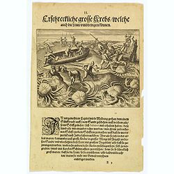
The Dutch are attacked by giant crabs.
During their return voyage, the Portuguese were wrecked on a sandbank (the Seychelles?) From the debris they began building a smaller ship in which they hoped to return t...
Place & Date: Frankfurt, 1598

Barbariae et Biledulgerid, nova descriptio.
North-West Africa. Koeman speculated: "In view of the important trading relationship between Antwerp and Africa, it is not impossible that the original was a manuscr...
Place & Date: Antwerp, 1598
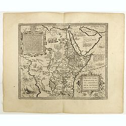
Presbiteri Johannis, sive Abissinorum Imperii descriptio.
Depicting Africa from the Mediterranean to the Mountains of the Moon placed just below Mozambique. Dare to go in Black. All early maps were printed in black and white,...
Place & Date: Antwerp, 1598
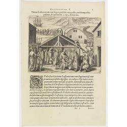
Argumentum I. Primus Lufitanorum cum Sogni praefecto congreffus, eiusdemque Baptismus, de quibus lib. 2 cap 2. fit mentio. (The arrival of the Portuguese in the county Sogno)
The arrival of the Portuguese in the county Sogno. When the Portuguese first discovered the county and the inhabitants of Sogno, they were taken for gods and received wit...
- $100 / ≈ €94
Place & Date: Frankfurt, 1598
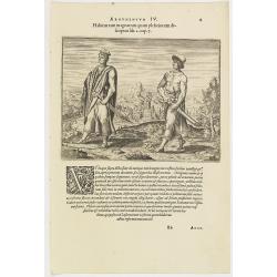
Argumentum IV. Habitus tam magnatum quam plebeiorum descriptus lib. 2 cap. 7. (How the Congolese men dress)
This shows what the inhabitants of the Congo wore before the Portuguese arrived. The men had small square berets, usually red or yellow, more for decoration than as prote...
- $100 / ≈ €94
Place & Date: Frankfurt, 1598
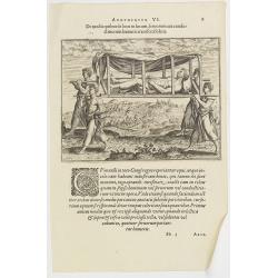
Argumentum VI. De modis quibus de loco in locum, feruorum aut conductitiorum humeris transferri Folent. (How the Congolese are transported)
How the Congolese are transported. None of the horses (probably zebras) are tame enough to ride and the people seem incapable of training the oxen to pull wagons for the ...
- $100 / ≈ €94
Place & Date: Frankfurt, 1598
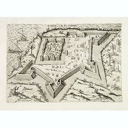
Fortezza di Gerbi.
Rare and early plan the fortress in present-day Jarbah Hawmat-as on the Tunisian island of Djerba, the largest African island in the Mediterranean.The fortress is still o...
- $2200 / ≈ €2059
Place & Date: Rome, 1586 / 1602
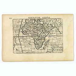
Africa.
A lovely miniature map of the continent of Africa, published by Petrus Bertius, in Amsterdam at the beginning of the seventeenth century. There is a small strap-work titl...
Place & Date: Amsterdam, 1606
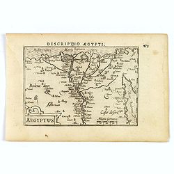
Aegyptus.
A fine miniature map of Egypt, published by Petrus Bertius in Amsterdam early in the seventeenth century. The lovely map and has a strap-work title, in the lower left cor...
- $100 / ≈ €94
Place & Date: Amsterdam, 1606
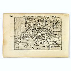
Barbaria.
A nice miniature map of the north African region known as 'Barbary', published by Petrus Bertius in Amsterdam early in the seventeenth century. This lovely map also depic...
- $100 / ≈ €94
Place & Date: Amsterdam, 1606
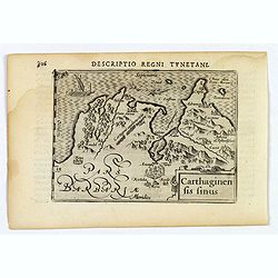
Carthaginensis Sinus.
A beautifully miniature map by Petrus Bertius of the ancient city of Carthage and the more modern town of Tunis, first published in 1598. There are numerous features tha...
- $100 / ≈ €94
Place & Date: Amsterdam, 1606
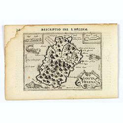
Sancta Helena.
An attractive small map of the south Atlantic island of St. Helena. Two years after the publication of Linschoten's Itinerario, the first map of St. Helena appeared in 15...
- $100 / ≈ €94
Place & Date: Amsterdam, 1606
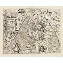
Insulae et arcis Mocambique descriptio ad fines Melinde sita ebano puriss.
Attractive bird's-eye view of Melinde harbor in Mozambique showing the fortifications with numerous ships at anchor in the protected harbor. The map is finely engraved an...
- $300 / ≈ €281
Place & Date: Frankfurt, 1607
Africae Descriptio.
Map of Africa from the first French-text edition of Jodocus Hondius' Atlas Minor.Shortly after the publication of the big folio-atlases the need was apparently felt for a...
Place & Date: Amsterdam, 1608
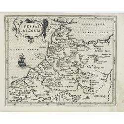
Fessae Regnum.
Charming small map of the northwestern tip of Africa with Fez showing as the principal city. Decorative title cartouche.From a Latin-text edition of Jodocus Hondius' Atla...
- $120 / ≈ €112
Place & Date: Amsterdam, 1608

XIII. Repraesentatio Bestiarum ferarum Omnis Generis, quales in Guinea reperiuntur.
Fine engraving of Elephant and other wild animals. Theodore de Bry, a German engraver and book dealer, began a compilation of early voyages in 1590 and had published six ...
- $100 / ≈ €94
Place & Date: Frankfurt, 1609
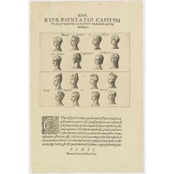
XXVI. Repraesentatio Capitum Praecipuarum Aliquot Personarum in Benyn.
Different types from Benin, in West Africa.Theodore de Bry, a German engraver and book dealer, began a compilation of early voyages in 1590 and had published six parts at...
- $75 / ≈ €70
Place & Date: Frankfurt, 1609
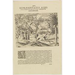
XIV. Repraesentatio Agriculturae et Fructuum Variorum exterra nafcentium.
Agriculture. Theodore de Bry, a German engraver and book dealer, began a compilation of early voyages in 1590 and had published six parts at the time of his death in 1598...
- $100 / ≈ €94
Place & Date: Frankfurt, 1609
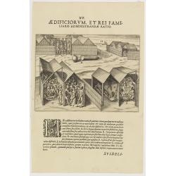
XV. Aedificiorum, et Rei Familiaris Administandae Ratio.
A village-scene in Guinea.Theodore de Bry, a German engraver and book dealer, began a compilation of early voyages in 1590 and had published six parts at the time of his ...
- $100 / ≈ €94
Place & Date: Frankfurt, 1609
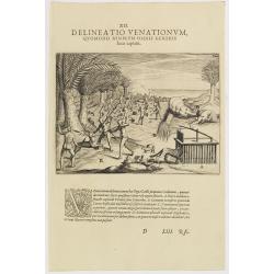
XII. Delineatio Venationum, quomodo Nimir um Omnis Generis feras capiant. (How the hunters catch animals: 1603-1604)
A: shows a leopard walking into a cage with a trap door. B: is an antelope, killed by natives, using ‘assagais’. C: shows rabbits being caught. They are frightened ou...
- $125 / ≈ €117
Place & Date: Frankfurt, 1609
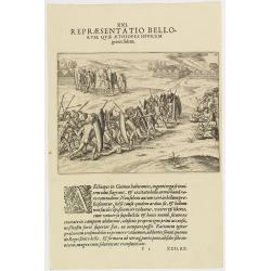
XXI. Repraesentatio Bellorum, Quae Aethiopes Invicem . . .
A fight between Ethiopian warriors.Theodore de Bry, a German engraver and book dealer, began a compilation of early voyages in 1590 and had published six parts at the tim...
- $75 / ≈ €70
Place & Date: Frankfurt, 1609