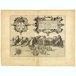
Browse Listings in Africa > Central Africa

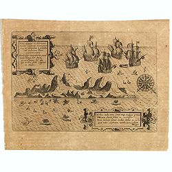
.Tabu nova partis Aphri.
Based on Waldseemüller's map. The maps show Northern Africa as it was known to Europeans at the first part of the 16th century. There is great details across north Afric...
Place & Date: Lyons, M. Servetus, 1535
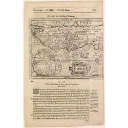
![[West Africa]](/uploads/cache/46529-250x250.jpg)
[West Africa]
Second block. West Africa, from the Tropic of Cancer south to St Thomas. The interior is filled with lions, elephants, monkeys and camels, with a fenced native village. O...
Place & Date: Venice, 1563
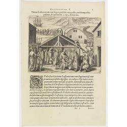
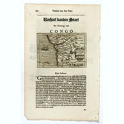
Argumentum I. Primus Lufitanorum cum Sogni praefecto congreffus, eiusdemque Baptismus, de quibus lib. 2 cap 2. fit mentio. (The arrival of the Portuguese in the county Sogno)
The arrival of the Portuguese in the county Sogno. When the Portuguese first discovered the county and the inhabitants of Sogno, they were taken for gods and received wit...
- $100 / ≈ €94
Place & Date: Frankfurt, 1598
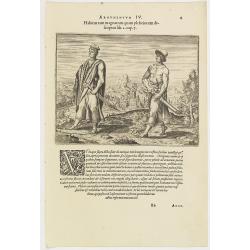
Argumentum IV. Habitus tam magnatum quam plebeiorum descriptus lib. 2 cap. 7. (How the Congolese men dress)
This shows what the inhabitants of the Congo wore before the Portuguese arrived. The men had small square berets, usually red or yellow, more for decoration than as prote...
- $100 / ≈ €94
Place & Date: Frankfurt, 1598
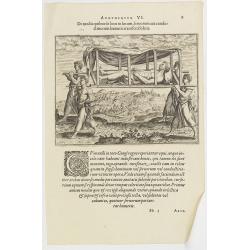
Argumentum VI. De modis quibus de loco in locum, feruorum aut conductitiorum humeris transferri Folent. (How the Congolese are transported)
How the Congolese are transported. None of the horses (probably zebras) are tame enough to ride and the people seem incapable of training the oxen to pull wagons for the ...
- $100 / ≈ €94
Place & Date: Frankfurt, 1598
Presbiteri Johannis, sive Abissinorum Imperii descriptio.
Depicting Africa from the Mediterranean to the Mountains of the Moon placed just below Mozambique. Dare to go in Black. All early maps were printed in black and white,...
Place & Date: Antwerp, 1598
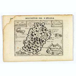
Sancta Helena.
An attractive small map of the south Atlantic island of St. Helena. Two years after the publication of Linschoten's Itinerario, the first map of St. Helena appeared in 15...
- $100 / ≈ €94
Place & Date: Amsterdam, 1606
Insulae et arcis Mocambique descriptio ad fines Melinde sita ebano puriss.
Attractive bird's-eye view of Melinde harbor in Mozambique showing the fortifications with numerous ships at anchor in the protected harbor. The map is finely engraved an...
- $300 / ≈ €281
Place & Date: Frankfurt, 1607
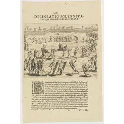
XVI. Delineatio Solennitatis, qua Nobiles Creari Solent.
Fine print of a Ceremony of electing or appointing a Nobleman in Guinea. Text below the engraving with an explanation in Latin : "During this ceremony there is a gre...
- $90 / ≈ €84
Place & Date: Frankfurt, 1609
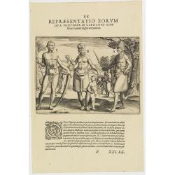
XX. Repraesentatio Eorum Quae Praeterea in Cabo Lopo Gonfalues. . . (More inhabitants of Cabo Lopo Gonsalues)
Here we see more figures of Cabo Lopo Gonsalues and Rio de Gabon. A: a distinguished man decked out in his finery and carrying several types of knives in his belt. In his...
- $100 / ≈ €94
Place & Date: Frankfurt, 1609
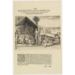
XIX. Repraesentatio Maiestatis, qua rex in Cabo Lopo Gonsalves . . . (How the chief of Cabo Lopo Gonsalues presents himself )
This describes the places they call Cabo Lopo Gonsalues and Rio de Gabon, where the chief receives his visitors. He sits on a chair placed upon a platform with two or thr...
- $100 / ≈ €94
Place & Date: Frankfurt, 1609
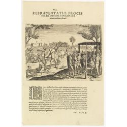
VII. Repraesentatio Processus in Iudiciis Civilibus et Criminalibus Ufitati. (Courts and Administration of Justice)
A depiction of the court and administration of justice. Seven features are identified : (A) the king or chief listening to a case presented to him, (B) the beheading of a...
- $90 / ≈ €84
Place & Date: Frankfurt, 1609
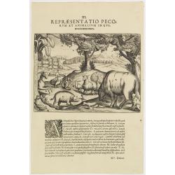
XI. Repraesentatio Pecorum et animalium in Guinea cicuratorum.
Various animals and birds from Africa. Engraved and published by Theodore de Bry, a German engraver and book dealer, began a compilation of early voyages in 1590 and had ...
- $100 / ≈ €94
Place & Date: Frankfurt, 1609

XIII. Repraesentatio Bestiarum ferarum Omnis Generis, quales in Guinea reperiuntur.
Fine engraving of Elephant and other wild animals. Theodore de Bry, a German engraver and book dealer, began a compilation of early voyages in 1590 and had published six ...
- $100 / ≈ €94
Place & Date: Frankfurt, 1609
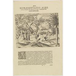
XIV. Repraesentatio Agriculturae et Fructuum Variorum exterra nafcentium.
Agriculture. Theodore de Bry, a German engraver and book dealer, began a compilation of early voyages in 1590 and had published six parts at the time of his death in 1598...
- $100 / ≈ €94
Place & Date: Frankfurt, 1609
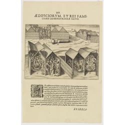
XV. Aedificiorum, et Rei Familiaris Administandae Ratio.
A village-scene in Guinea.Theodore de Bry, a German engraver and book dealer, began a compilation of early voyages in 1590 and had published six parts at the time of his ...
- $100 / ≈ €94
Place & Date: Frankfurt, 1609
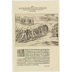
XXI. Repraesentatio Bellorum, Quae Aethiopes Invicem . . .
A fight between Ethiopian warriors.Theodore de Bry, a German engraver and book dealer, began a compilation of early voyages in 1590 and had published six parts at the tim...
- $75 / ≈ €70
Place & Date: Frankfurt, 1609
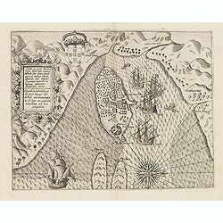
Insula D.Helenae sacra coeli Clementia . . .
A fine perspective view of the Island of St.Helena in the South Atlantic. The location of the Island directly on the navigation route from Europe to the Cape of Good Hope...
- $750 / ≈ €702
Place & Date: Frankfurt, 1609
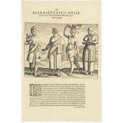
III. Repraesentatio Mullierum, et vestimentorum, Quibus Utuntur.
Inhabitants of the coast of the Ivory coast in Africa.Theodore de Bry, a German engraver and book dealer, began a compilation of early voyages in 1590 and had published s...
- $75 / ≈ €70
Place & Date: Frankfurt, 1609
Vera effigies et delineatio Infulce Ascenstio. . . (St. Helena)
Striking view of the Island of Ascuncion (St. Helena).Theodore de Bry, a German engraver and book dealer, began a compilation of early voyages in 1590 and had published s...
- $100 / ≈ €94
Place & Date: Frankfurt, 1609
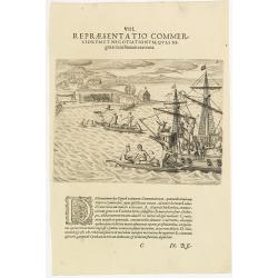
VIII. Repraesentatio Commerciorum et Negotiationum, Quas Nigritae cum Batauis exercent.
Locals from Gold Coast trying to sell items to the crew of a Dutch vessel. Theodore de Bry, a German engraver and book dealer, began a compilation of early voyages in 159...
- $100 / ≈ €94
Place & Date: Frankfurt, 1609
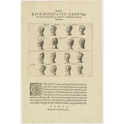
XXVI. Repraesentatio Capitum Praecipuarum Aliquot Personarum in Benyn.
Different types from Benin, in West Africa.Theodore de Bry, a German engraver and book dealer, began a compilation of early voyages in 1590 and had published six parts at...
- $75 / ≈ €70
Place & Date: Frankfurt, 1609
Abissinorum Imperium. / Acomath .I. Turcarum Imperator .XIIX. Ex Stirp. Ottomannica.
Map of central Africa. Copperplate engraving on text leaf with letterpress on verso. The engraving depicts a half length oval portrait of "Acomath I".Nicolaes d...
Place & Date: Amsterdam, Cloppenburch, 1621
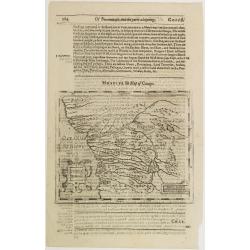
Congo Regnum Christian. In Africa.
Small map illustrating the western seashores of Central Africa, surrounded by text in Dutch.Nicolaes de Clerck (de Klerc) was active as engraver and publisher in Delft fr...
Place & Date: Amsterdam, Cloppenburch, 1621
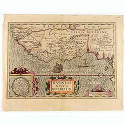
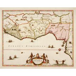
Guineae Nova Descriptio.
The map shows the West African coast from Senegal (the 'Rio Senega' is the Senegal River) to Cape Lopez on the Gulf of Guinea just below the equator.The island of St. Tho...
- $700 / ≈ €655
Place & Date: Amsterdam, 1628
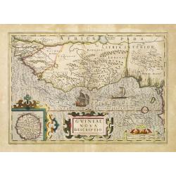
Guineae Nova Descriptio.
The map shows the West African coast from Senegal (the 'Rio Senega' is the Senegal River) to Cape Lopez on the Gulf of Guinea just below the equator. The island of St. Th...
- $450 / ≈ €421
Place & Date: Amsterdam, 1630
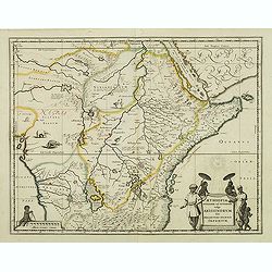
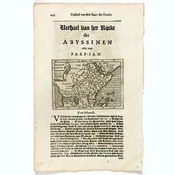
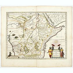
Aethiopia Superior vel Interior vulgo Abissinorum.
An attractive map of Eastern Africa and the fictitious kingdom of Prester John. The map shows a major section of central and eastern Africa including Mozambique north to ...
- $450 / ≈ €421
Place & Date: Amsterdam, 1638
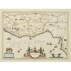
Guinea.
An attractive map covered with intersecting rhumb lines and decorated with monkeys, lions, elephants and native figures. With a dedication to Dr. Nicolas Tulp.As Willem B...
- $750 / ≈ €702
Place & Date: Amsterdam, 1638
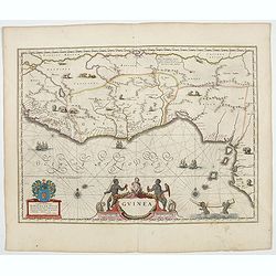
Guinea.
An attractive map covered with intersecting rhumb lines and decorated with monkeys, lions, elephants and native figures. With a dedication to Dr. Nicolas Tulp.
- $750 / ≈ €702
Place & Date: Amsterdam, 1640
Aethiopia Superior vel Interior vulgo Abissinorum.
An attractive map of the Eastern African and the fictitious kingdom of Prester John. The map shows a major section of central and eastern Africa including Mozambique nort...
- $900 / ≈ €842
Place & Date: Amsterdam, 1644
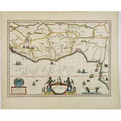
Guinea.
An attractive map covered with intersecting rhumb lines and decorated with monkeys, lions, elephants and native figures. With a dedication to Amsterdam anatomist and phys...
- $750 / ≈ €702
Place & Date: Amsterdam, 1644
Guinea.
Samuel Purchas' edition of the Mercator/Hondius Atlas Minor . Map of Guinea published in his famous collection of voyages His Pilgrimes . With descriptive text in English...
Place & Date: London, 1645

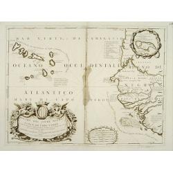
Carta particolare che comincia con il c.apo Aldea è Finisce con il capo Degortam. . .
Dudley’s magnificent chart shows the south west coast of Africa. A first edition without the privilege..Engraved by Lucini.Sir Robert Dudley's Dell'Arcano del Mare is t...
- $1250 / ≈ €1170
Place & Date: Florence, 1645
Congi regnu.
Samuel Purchas' edition of the Mercator/Hondius Atlas Minor . Early map of Congo published in his famous collection of voyages His Pilgrimes . With descriptive text in En...
- $100 / ≈ €94
Place & Date: London, 1645

Pas-Caart van Guinea en den Custen daer aen gelegen Van C..
A decorative chart of the southwest coast of Africa, embellished with an elaborate, finely colored title-cartouche, and 2 compass-roses. Pieter Goos (ca. 1616-1675) was o...
Place & Date: Amsterdam, 1666

Paskaart van Guinea van C.Verde tot R. deGalion.
Rare edition of Doncker's sea chart of Guinea coast. From an atlas printed in 1668, "l'Atlas de MER ou MONDE AQUATIQUE, Remontrant toutes lescôtes de la Mer…"...
- $1000 / ≈ €936
Place & Date: Amsterdam, 1660-1668

Tractus Littorales Guineae a Promontorio Verde usque ad sinum Catenbelae.
Chart of the West coast of Africa from Mauritania up to Angola. In top centre a very decorative title cartouche.
Place & Date: Amsterdam, 1675
Guinea.
A close copy of the map by Blaeu. Covers the Guinea and Benin coast. A very decorative map with a large title cartouche. At bottom right two putti area carrying an elepha...
- $1100 / ≈ €1029
Place & Date: Amsterdam, 1680
![Loandas St.Paulo [Luanda]](/uploads/cache/48500-250x250.jpg)
Loandas St.Paulo [Luanda]
Engraved by Thomas Doesburgh (active between 1683 and 1714) for Carolus Allard's for his Orbis habitabilis oppida et vestitus the print shows a distance view of the Angol...
- $150 / ≈ €140
Place & Date: Amsterdam, c.1685-1690
Bocche del Fiume Negro et Isole di Capo Verde.
Double-page engraved map of the Cape Verde Islands and part of the coast of Senegal, with large decorative cartouche. One with inset of the island Goree. During three cen...
Place & Date: Venice, 1690