Browse Listings in America
![[The Dutch covalesce on the Isle Santa Clara.]](/uploads/cache/40359-250x250.jpg)
[The Dutch covalesce on the Isle Santa Clara.]
Many of the Dutch were in poor health after their Atlantic crossing and when they found an island to the north of Rio de Janeiro, called Santa Clara, (I. do Francez) they...
Place & Date: Frankfurt, M.Merian, 1633
![[Soil map] Virginia-Maryland-West Virginia, Leesburg sheet.](/uploads/cache/23257-250x250.jpg)
[Soil map] Virginia-Maryland-West Virginia, Leesburg sheet.
Early color lithographed soil map by Julius Bien & Co. in New York for Department of Agriculture. Legends at side give detail on soil type, etc. They also include int...
Place & Date: New York, 1903

A-Na-Cam-E-Gish-Ca. A Chippeway Chief.
Half-length portrait of Anacamegishca, bare-chested, wearing a blanket and a peace medal. A-Na-Cam-E-Gish-Ca (1785-1862) - was a Chippeway Indian Chief. The Chippewa is o...
Place & Date: Philadelphia, 1837

Ca-Ta-He-Cas-Sa-Black Hoof. Principal Chief of the Shawanoes.
Half-length portrait of Catahecassa wearing a dark colored jacked, grey vest, white shirt, and grey head scarf.A wonderful hand colored lithograph of Ca-Ta-He-Cas-Sa-Blac...
Place & Date: Philadelphia, 1837

Major Ridge. A Cherokee Chief.
Head and shoulders portrait of Major Ridge,(1771-1839) wearing a blue jacket, gold or yellow vest, white shirt, and black cravat. A Cherokee Chief, who as a Cherokee lead...
Place & Date: Philadelphia, 1837

Carte du Canada ou de la Nouvelle France.
A later edition of Guillaume De l'Isle's map. It still includes the fictitious discoveries of Baron de Lahoutan: the legendary River Longue etc. The northwest corner of H...
Place & Date: Amsterdam, 1730

Guyana, Surinam, Amapa.
Very rare Ottoman printed map of Guyana, Suriname and Amapa. With Trinidad, an inset map of the mouth of the Rivers Essequibo, Courantyne, Suriname with Paramaribo.From C...
Place & Date: Üsküdar (Istanbul), 1803

Carte des Iles Hawaii.
A lovely small map of the complete chain of Pacific islands known today as the Hawaiian islands, from Dumont d'Urville's atlas "Voyage pittoresque autour du Monde.&q...
Place & Date: Paris, 1834

Americae Pars Magis Cognita. Chorographia nobilis & opulentae Peruanae Provinciae, atque Brasiliae, . . . MDXCII
First state. Although a map of South America it does include much of what is now the southern United States. There are two elaborate, strap-work cartouches with the one a...
Place & Date: Frankfurt, 1592
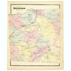
Town of Bedford Westchester Co. NY.
Fine lithographed map of the town of Bedford. The map provides the names of specific homeowners, as well as information about the occupations and physical locations of th...
Place & Date: New York, 1867

Plan of Yonkers Town of Yonkers Westchester Co. N.Y. . . .
Fine lithographed map of Yonkers, New York. The map provides the names of specific homeowners, as well as information about the occupations and physical locations of the ...
Place & Date: New York, 1867

Plan of the Borough of New Rochelle, Westchester Co. N.Y.
Fine lithographed map of the plan of the Borough of New Rochelle. The map provides the names of specific homeowners, as well as information about the occupations and phys...
Place & Date: New York, 1867

Plan of the Beekmanton Tarryntown and Ivring. Westchester Co. N.Y.
Fine lithographed map of the plan of the Beekmantown, Tarrytown, and Irving, New York. The map provides the names of specific homeowners, as well as information about the...
Place & Date: New York, 1867

New Jersey entworfen von D.F. Sotzmann. Hamburg bey Carl Ernst Bohn 1796 . . . NO.VIII
Extremely rare map of New Hampshire prepared by Daniel Friedrich Sotzmann for Christopher Ebeling's "Erdbeschreibung von Amerika", a project ended after only te...
Place & Date: Hamburg, Carl Ernst Bohn, 1797

New Yok entworfen von D.F. Sotzmann. Hamburg bey Carl Ernst Bohn 1799 . . . NO.VII
An extremely rare map of New York prepared by Daniel Friedrich Sotzmann for Christopher Ebeling's "Erdbeschreibung von Amerika", a project ended after only ten ...
Place & Date: Hamburg, Carl Ernst Bohn, 1799

Rhode Island entworfen von D.F. Sotzmann. Hamburg bey Carl Ernst Bohn 1798 . . . NO.V
Extremely rare map of Rhode Island prepared by Daniel Friedrich Sotzmann for Christopher Ebeling's "Erdbeschreibung von Amerika", a project ended after only ten...
Place & Date: Hamburg, Carl Ernst Bohn, 1797

Americae Nova Descriptio.
Final state. According to Philip Burden, "this scarce map is America's first single-sheet map with decorative borders." A re-issue of the 1614 plate by Pieter v...
Place & Date: Amsterdam, 1652

A plan of the City and Environs of Philadelphia. . .
The Lotter edition of Scull & Heap's seminal Philadelphia map, which map was first issued in 1752.Holmes' grid plan for the city is shown, situated between the rivers...
Place & Date: Augsburg, 1777

North and South America At-A-Glance.
A clever device for demonstrating the statistics of each country, the Area, Population, Population per Sq. Mile, Highest Elevation, Principal River, Currency, Capital, Fo...
Place & Date: New York & London: International At-A-Glance Chart Co. 1931

United States At-A-Glance.
A clever device for demonstrating the statistics of each state, the Area, Population, Highest Elevation, Principal River, Capital, railroad Mileage, Date Entered Union, P...
Place & Date: New York & London: International At-A-Glance Chart Co. 1931

Mar del Zur, Hispanis Mare Pacificum.
Janssonius' fine chart of the Pacific including the west coast of America with California shown as an island, Japan and a small Australian coastline. This is the earliest...
Place & Date: Amsterdam, 1650

20 small lithographed views of Washington DC and Georgetown.
20 small lithographed town-views of Washington DC and Georgetown, cut out from a larger sheet. Showing the East Front of the Capitol, Treasury, Smithsonian Institute, Pre...
Place & Date: Casimir Bohn, Washington, D.C.: 1849

Maris Pacifici.
From the rare Dutch text edition of the Theatrum of which according to van den Broecke only 100 copies are printed.This was the first printed map to be devoted solely to ...
Place & Date: Antwerp, 1598

Kiepert's Physikalische Wandkarten. VI. Nord-America.
Large folding school wall map of North and Central America printed in chromo-lithography. Published by Dieter Reimer and printed by Leopold Kraatz in Berlin. Three inset...
Place & Date: Berlin, Dieter Reimer, 1864
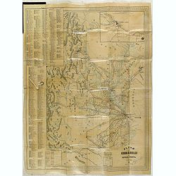
Plano de los Ferro-Carriles de Republica Argentina 1902.
Folding rail road map of Argentina, with inset of Buenos Aires in upper right corner.
Place & Date: Buenos Aires, ca. 1902

Il Cuscho citta principale della provincia del Peru.
A very desirable and scarce item of this decorative and early bid's-eye town-plan of the Inca city of Cuzco. Several figures shown inside the city walls and on the hillsi...
Place & Date: Lyons, 1564

Novissima et Accuratissima Totius Americae Descriptio.
Second state of Visscher's map of the Americas, this decorative map greatly influenced the cartography of the Americas both geographically and artistically.Although it di...
Place & Date: Amsterdam, 1677

Poli Arctici, et circumiacentium terrarum descriptio novissima. . .
A re-issue of the Hondius' plate. A particularly decorative map of the North Pole with Iceland. Several Dutch names in Labrador. The toponymy in Canada reflects the conti...
Place & Date: Amsterdam, 1660

Manuscript plan of Havana harbour.
Manuscript chart with good nautical detail and soundings of Havana harbour.
Place & Date: Spain c.1820
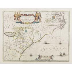
Virginiae Partis Australis, et Floridae Partis Orientalis.
Blaeu based this map on the Mercator-Hondius of 1606. A number of geographical improvements, however were incorporated, although two large fictions lakes accompanied by e...
Place & Date: Amsterdam, 1640
![[City Of New York and Environs].](/uploads/cache/27530-250x250.jpg)
[City Of New York and Environs].
A very decorative bird's-eye view of Manhattan, Brooklyn, and part of New Jersey. Manhattan Island from the southwest is surrounded by the Hudson, Harlem, East River, and...
Place & Date: New York, 1875

New York Ferry Boat. (Bac à vapeur de New York).
A very decorative print showing the New York Ferry Boat "Fulton," published by Currier & Ives. The Ferry boat "Fulton" sails to the right. A singl...
Place & Date: New York, ca. 1875

Les Isles Terceres. . .
Uncommon map of the Azores. Engraved by Sommer. Du Val is mentioned as the cartographer and the publisher was Pierre Mariette.
Place & Date: Paris, c. 1650 - 1676

Les deux poles articque ou septentrional et antarticque..
A double hemisphere map to the North and South poles. The North pole is connected to Greenland and Spitzbergen but there is little other detailed coastline in the polar a...
Place & Date: Paris, 1657
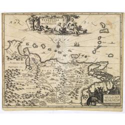
Venezuela cum parte Australi Novae Andalusiae.
Most decorative map with two large cartouches and compass-rose, large group of islands at the mouth of the Orinoco, other islands off Venezuela coast: Margarita, Aruba, C...
Place & Date: Amsterdam, 1673
Terra Firma et Novum Regnum Granatense et Popayan.
Detailed map of Panama and northwestern South America derived from the Blaeu/Jansson map of the regionFeaturing ships at sea, two compass roses, and two cartouches depict...
Place & Date: Amsterdam, 1673

Map of the Great Salt Lake And Adjacent Country in the Territory Of Utah. Surveyed in 1849 and 1850, under the orders of Col. J.J. Abert ...
Map of the Great Salt Lake And Adjacent Country in the Territory Of Utah. Surveyed in 1849 and 1850, under the orders of Col. J.J. Abert .. by Capt. Howard Stansbury .. a...
Place & Date: Ackerman, New York, 1852

Carte Réduite De La Partie Septentrionale De L'' Isle De Terre Neuve..
A well engraved and highly detailed chart, corrected to 1767. Elaborate hand-colored cartouche, rhumb lines.Shows northern part of Newfoundland and southern coast of Labr...
Place & Date: Paris, 1767

La Florida/ Peruviae Auriferae regionis Typus/ Guastecan.
The Chaves map of Florida is a prime example of an explorer's map since it records the recent discoveries of Cabeza de Vaca, De Soto, and Moscoso. The map revealed little...
Place & Date: Antwerp, 1592

Ilse Paese de' Selvaggi.. Lago Superiore. (Florida and the Bahamas)
Antonio Zatta published an Italian version of the John Mitchell map in twelve sheet. This sheet depicts Lake Superior in the Bellin version, as it appeared on the Mitchel...
Place & Date: Venice, 1778

Carte des côtes du Golfe du Mexique compris entre la pointe sud de la presqu'Ile de la Floride et la pointe nord de la presqu'Ile d'Yucatan: Dresée d'après le observations et las plans des espagnols, ...
Detailed and important early chart of the Gulf Coast and Florida and dated 1800. First French edition of "the first printed [map] to show and name Galveston Bay&qu...
Place & Date: Paris, 1800
![[Canadian Indian traditional garments ].](/uploads/cache/27544-250x250.jpg)
[Canadian Indian traditional garments ].
Aquatint depicting Canadian Indian traditional garments engraved by Gallina. Plate N°32.From Giulio Ferrario's work Le Costume Ancien et Moderne ou Histoire du gouvernem...
Place & Date: Milan, 1827
![[Canadian Indians ].](/uploads/cache/27546-250x250.jpg)
[Canadian Indians ].
Aquatint depicting a group of Canadian Indians engraved by Gallina. Plate N° 33 n°1.From Giulio Ferrario's work Le Costume Ancien et Moderne ou Histoire du gouvernement...
Place & Date: Milan, 1827
![[View of the Potomac River from Mount Vernon ].](/uploads/cache/27550-250x250.jpg)
[View of the Potomac River from Mount Vernon ].
Aquatint depicting a view of the Potomac River from Mount Vernon engraved by Fumagalli. Plate N°46.From Giulio Ferrario's work Le Costume Ancien et Moderne ou Histoire d...
Place & Date: Milan, 1827
![[Florida Indian cooking ].](/uploads/cache/27561-250x250.jpg)
[Florida Indian cooking ].
Aquatint depicting Florida Indian cooking engraved by Fumagalli. Plate N°54.From Giulio Ferrario's work Le Costume Ancien et Moderne ou Histoire du gouvernement, de la m...
Place & Date: Milan, 1827
![[Slave labor on an indigo plantation ].](/uploads/cache/27564-250x250.jpg)
[Slave labor on an indigo plantation ].
Aquatint depicting slave labor on an indigo plantation engraved by Fumagalli. Plate N°51.From Giulio Ferrario's work Le Costume Ancien et Moderne ou Histoire du gouverne...
Place & Date: Milan, 1827
![[Slave labor on a Tobacco plantation ].](/uploads/cache/27565-250x250.jpg)
[Slave labor on a Tobacco plantation ].
Aquatint depicting slave labor on an tobacco plantation engraved by Biasioli. Plate N°50.From Giulio Ferrario's work Le Costume Ancien et Moderne ou Histoire du gouverne...
Place & Date: Milan, 1827
![[ Indian accessories ].](/uploads/cache/27566-250x250.jpg)
[ Indian accessories ].
Aquatint depicting Indian accessories engraved by Gallina. Plate N°49.From Giulio Ferrario's work Le Costume Ancien et Moderne ou Histoire du gouvernement, de la milice,...
Place & Date: Milan, 1827
![[ Chief Regolo ].](/uploads/cache/27567-250x250.jpg)
[ Chief Regolo ].
Aquatint depicting Chief Regolo (also called Cacique) accompanied by his women engraved by Gallina. Plate N°57.Cacique from the taíno word for the pre-Columbian tribal ...
Place & Date: Milan, 1827
![[ Chief Regolo ].](/uploads/cache/27568-250x250.jpg)
[ Chief Regolo ].
Aquatint depicting chief warriors engraved by G. G. Plate N°58.Cacique from the taíno word for the pre-Columbian tribal chiefs or leaders, of the Taino tribes in the Ba...
Place & Date: Milan, 1827
![[ Cofre de Perote ].](/uploads/cache/27569-250x250.jpg)
[ Cofre de Perote ].
Aquatint depicting the Cofre de Perote engraved by Fumagalli. Plate N°59.Cofre de Perote, mean something like 'Mountain of the Lord of Four Places'. This extinct volcano...
Place & Date: Milan, 1827
![[ Regla columnar basalt quarry ].](/uploads/cache/27570-250x250.jpg)
[ Regla columnar basalt quarry ].
Aquatint depicting columnar basalt quarry engraved by Fumagalli. Plate N°60.This common extrusive volcanic rock is used for highway construction, railroad ballast, and t...
Place & Date: Milan, 1827
![[ Jorullo Volcano ].](/uploads/cache/27571-250x250.jpg)
[ Jorullo Volcano ].
Aquatint depicting the Jorullo Volcano engraved by Fumagalli. Plate N°61.El Jorullo is a cinder cone volcano in Michoacán, central Mexico in an area known as the Michoa...
Place & Date: Milan, 1827
![[ Portraits of Motezuma II and Cortes ].](/uploads/cache/27573-250x250.jpg)
[ Portraits of Motezuma II and Cortes ].
Aquatint depicting two portraits of Motezuma II and Cortes engraved by Gallina. Plate N°63.Montezuma II was trained as a priest and rose to become leader of the Aztecs i...
Place & Date: Milan, 1827
![[ Montezuma II As Represented in an Anonymous Codex in The Vatican ].](/uploads/cache/27574-250x250.jpg)
[ Montezuma II As Represented in an Anonymous Codex in The Vatican ].
Aquatint depicting Motezuma II represented in the Vatican's anonymous codex engraved by DKB. Plate N°64.The Codex Vaticanus, so called because it is the most famous manu...
Place & Date: Milan, 1827
![[ Mexican weapons ].](/uploads/cache/27575-250x250.jpg)
[ Mexican weapons ].
Aquatint depicting Mexican weapons engraved by DKB. Plate N°65.From Giulio Ferrario's work Le Costume Ancien et Moderne ou Histoire du gouvernement, de la milice, de la ...
Place & Date: Milan, 1827
![[ Mexican weapons ].](/uploads/cache/27576-250x250.jpg)
[ Mexican weapons ].
Aquatint depicting an Oaxaca monument representing a warrior engraved by Bonatti. Plate N°66.Oaxaca is the historic home of the Zapotec and Mixtec peoples, and contains ...
Place & Date: Milan, 1827
![[ Aztec low relief representing ancient warriors ].](/uploads/cache/27577-250x250.jpg)
[ Aztec low relief representing ancient warriors ].
Aquatint depicting an Oaxaca monument representing a warrior engraved by Bonatti. Plate N°67.From Giulio Ferrario's work Le Costume Ancien et Moderne ou Histoire du gouv...
Place & Date: Milan, 1827
![[ Hieroglyph representing the Cihuacohuat Goddess ].](/uploads/cache/27578-250x250.jpg)
[ Hieroglyph representing the Cihuacohuat Goddess ].
Aquatint depicting a hieroglyph representing the Cihuacohuat Goddess engraved by DKB. Plate N°68.From Giulio Ferrario's work Le Costume Ancien et Moderne ou Histoire du ...
Place & Date: Milan, 1827
![[ Azrec Idols ].](/uploads/cache/27579-250x250.jpg)
[ Azrec Idols ].
Aquatint depicting Aztec idols engraved by Gallina. Plate N°698.From Giulio Ferrario's work Le Costume Ancien et Moderne ou Histoire du gouvernement, de la milice, de la...
Place & Date: Milan, 1827
![[Human sacrifice.]](/uploads/cache/27582-250x250.jpg)
[Human sacrifice.]
Aquatint depicting a human sacrifice engraved by Gallina. Plate N°72.From Giulio Ferrario's work Le Costume Ancien et Moderne ou Histoire du gouvernement, de la milice, ...
Place & Date: Milan, 1827
![[ Gladiators ].](/uploads/cache/27583-250x250.jpg)
[ Gladiators ].
Aquatint depicting gladiators in combat engraved by Gallina. Plate N°73.From Giulio Ferrario's work Le Costume Ancien et Moderne ou Histoire du gouvernement, de la milic...
Place & Date: Milan, 1827
![[ Local Mexican Indian game, the Voladores de Papantla ].](/uploads/cache/27587-250x250.jpg)
[ Local Mexican Indian game, the Voladores de Papantla ].
Aquatint depicting local game engraved by Fumagalli. Plate N°77.The Aztecs also had spectacular dances such as the Voladores de Papantla ,the Sun Dance, in which the dan...
Place & Date: Milan, 1827
![[ Acrobatic games ].](/uploads/cache/27589-250x250.jpg)
[ Acrobatic games ].
Aquatint depicting acrobatic games engraved by Gallina. Plate N°78.From Giulio Ferrario's work Le Costume Ancien et Moderne ou Histoire du gouvernement, de la milice, de...
Place & Date: Milan, 1827
![[ Bread making ].](/uploads/cache/27591-250x250.jpg)
[ Bread making ].
Aquatint depicting a family making bread engraved by Gallina. Plate N°82.From Giulio Ferrario's work Le Costume Ancien et Moderne ou Histoire du gouvernement, de la mili...
Place & Date: Milan, 1827
![[ Mexican traditional garments ].](/uploads/cache/27592-250x250.jpg)
[ Mexican traditional garments ].
Aquatint depicting Mexican traditional garments engraved by Gallina. Plate N°83.From Giulio Ferrario's work Le Costume Ancien et Moderne ou Histoire du gouvernement, de ...
Place & Date: Milan, 1827
![[ Hieroglyph Christian calendar written in an Aztec style ].](/uploads/cache/27593-250x250.jpg)
[ Hieroglyph Christian calendar written in an Aztec style ].
Aquatint depicting Hieroglyph Christian calendar written in an Aztec style engraved by BonattiB. Plate N°84.From Giulio Ferrario's work Le Costume Ancien et Moderne ou H...
Place & Date: Milan, 1827
![[ Mechoacan Indians traditional garments ].](/uploads/cache/27594-250x250.jpg)
[ Mechoacan Indians traditional garments ].
Aquatint depicting Mechoacan Indians traditional garments engraved by Gallina. Plate N°85.From Giulio Ferrario's work Le Costume Ancien et Moderne ou Histoire du gouvern...
Place & Date: Milan, 1827

Plan der Stadt Quebec Haupstadt in Neu Franckreich oder Canada.
Town-plan of Quebec, with an inset view of the town in the lower right corner. In the upper right a recapitulation of the main military actions prior to the surrender of ...
Place & Date: Nurnberg, 1770

Pascaerte van Brazil en Nieu Nederlandt van Cuorvo en Flores.
A rare chart of the Atlantic Ocean from the first edition of Hendrick Doncker's Zee-Atlas, of which no surviving example is known.Although the idea of its unusual coverag...
Place & Date: Amsterdam, 1658
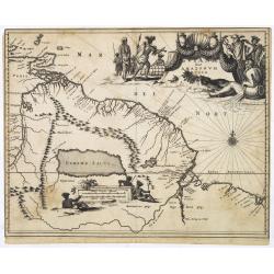
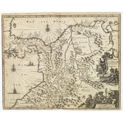
Guiana sive Amazonum Regio.
Map of Guiana and Amazon extending westwards to Trinidad and Margarita Island, dominated by a huge inland sea north of the Amazon.Embellished with decorative title and sc...
Place & Date: Amsterdam, 1673

Yucatan . . . Et Guatimala Conventus Iuridicus.
Very attractive map encompassing the Mexican heartland, the Yucatan peninsula, and the old Spanish Audiencia of Guatemala including Honduras, Nicaragua, Costa Rica and pa...
Place & Date: Amsterdam, 1673

Brasila.
Map of Brazil extending from C. Nasou and Parime Lago to the Mouth of the Rio de la Plata. Oriented with West on top.The cartography of the region is quite primitive. The...
Place & Date: Amsterdam, 1673

Insulae Americanae in Oceanus Septentrionali cum Terris..
General map of the West Indies extending from Virginia to the mouth of the Orinoco, and destined to be copied in various shapes by many other publishers. Title cartouche ...
Place & Date: Amsterdam, 1647

Pas-kaart vande Zee kusten van Venecuela met de Byleggende Eylanden. . .
Rare chart of the coast of Venezuela, including the islands of Curaçao, Bonaire, Aruba, etc.The chart has two insets, one (15x22cm) with a map of Curaçao, one smaller w...
Place & Date: Amsterdam, 1680

Paraguay, Chili, Terre Magellan ?
Map of Paraguay, Chili, and Argentina . By C. F. Delamarche, successor of Robert de Vaugondy, Geographer.
Place & Date: Paris, 1794 -1806

Virginiae Partis Australis, et Floridae Partis Orientalis.
Blaeu based this map on the Mercator-Hondius of 1606. A number of geographical improvements, however were incorporated, although two large fictions lakes accompanied by e...
Place & Date: Amsterdam, 1640

Histoire de la Guerre Civile en Amerique par M. Le Comte de Paris, Ancien Aide de Camp du General Mac Clellan (McClellan). ...
These 30 maps were made by Vorzet to accompany Louis Phillipe d'Orleans' (Comte de Paris) multi volume "Histoire de la Guerre Civile en Amérique". The set incl...
Place & Date: Paris. Michel Levy Freres, 1875

The Traveller's Guide. A Map Of The Roads, Canals And Steam Boat Routes Of The United States ... Designed for the use of Travellers, By H.S. Tanner.
Rare first edition of Tanner's travel map in pocket map form, in it original red leather covers, with the map and no text, as issued. Ristow says the first edition was 18...
Place & Date: Philadelphia, 1825

Carte D'Amerique Divisée en ses Principaux Pays. . .
Rare. Uncommon and decorative wall map of America, prepared by Clouet. With superb decorative borders, 170mm wide at the sides and 150mm at the bottom, containing twenty ...
Place & Date: Paris, Cadiz, 1785