Browse Listings
![[Lot of 4 charts] Plan de la Baie et du Port de Camraigne / Plan de la Baie de Niatrang et du Golfe de Binkang / Plan de la Cote de Cochinchine. . . / Plan des Ports de Xuandai, Vung-Lam. . .](/uploads/cache/44795A-250x250.jpg)
[Lot of 4 charts] Plan de la Baie et du Port de Camraigne / Plan de la Baie de Niatrang et du Golfe de Binkang / Plan de la Cote de Cochinchine. . . / Plan des Ports de Xuandai, Vung-Lam. . .
[A set of four French sea charts numbered consecutively]. A set of 4 basic coastal sea charts of parts of southern French Indochina (Vietnam).Chart 295 centers on the reg...
Place & Date: Paris ca 1780

Het West Indisch Huys.
A decorative print of the West Indian House , the headquarters of the WIC, a place for meeting, trading and storage of spices and ship equipment. The maps and charts were...
Place & Date: Amsterdam, J. van Meurs, 1663
-250x250.jpg)
Israel.
Decorative poster advertising flights to Israel made by Georges Mathieu. The poster is one of a series of 15 composed of posters of Greece, Israel, Germany, Great Britai...
Place & Date: Paris, 1967
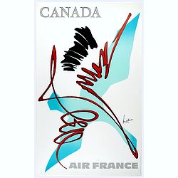
Canada.
Decorative poster advertising flights to Canada made by Georges Mathieu. The poster is one of a series of 15 composed of posters of Greece, Israel, Germany, Great Britai...
Place & Date: Paris, 1967

Hong Kong.
Decorative poster advertising flights to Hong Kong made by Georges Mathieu. The poster is one of a series of 15 composed of posters of Greece, Israel, Germany, Great Bri...
Place & Date: Paris, 1967
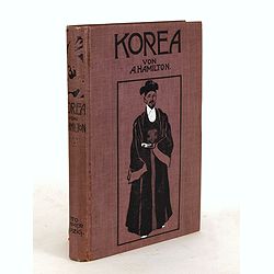
Korea. Das Land des Morgenrots. Nach seinen Reisen geschildert von Angus Hamilton. Autorisierte Übersetzung aus dem Englischen.
With 114 illustrations after photographes and one map.
Place & Date: Leipzig: Spamer, 1904

Voyage of his majesty’s ship Alceste, along the Coast of Corea, to the island of Lewchew, with an account of her subsequent shipwreck, by John M’LEOD. Surgeon of the Alceste.
Second and best edition, with frontispiece portrait of Captain Maxwell and five fine hand-colored aquatint plates, including a plate not present in the first edition of t...
Place & Date: London, John Murray, 1818

Paldobundo Province.
Woodblock printed map of Jeolla Province which was one of the historical Eight Provinces of Korea during the Kingdom of The map is drawn in "Paldo Bundo," styl...
Place & Date: 1710-1718
![Ch'onha chido.[Atlas of all under Heaven]](/uploads/cache/44639composition-world-250x250.jpg)
Ch'onha chido.[Atlas of all under Heaven]
A late 18th century Ch'onha chido atlas with 13 woodblock maps showing the World, China, Korea, Japan, Okinawa, and the 8 provinces. The seas are in black.
Place & Date: Korea, ca. 1760

Tabula Anemographica seu Pyxis Nautica.
Impressive compass rose with a fleur de lis at the center and 32 wind directions flowing from it identified in six languages, Greek, Latin, French, Dutch, Italian, and Sp...
Place & Date: Amsterdam, 1650