Browse Listings

Cunard to Canada.
Poster by Charles Eddowes Turner for Cunard lines. The poster shows The NEW SYLVANIA, one of the four new 22,000 - ton Cunarders which are the largest ever built for serv...
Place & Date: England, ca. 1930

Het Beloofde Landt Canaan door wandelt . . .
A beautifully engraved map of the ancient land of Canaan which roughly corresponds to present-day Israel. Cherubs hold up a draped cloth of key symbols, also a scale pane...
Place & Date: Amsterdam, 1682

La Florida/ Peruviae Auriferae regionis Typus/ Guastecan.
The Chaves map of Florida is a prime example of an explorer's map since it records the recent discoveries of Cabeza de Vaca, De Soto, and Moscoso. The map revealed little...
Place & Date: Antwerp, 1592
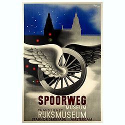
Spoorweg Museum Thans in Het Rijksmuseum.
Interesting Art Deco style poster for the Railway Museum, now in the Rijksmuseum. Carolus Adrianus Maria Thole (20 April 1914 – 26 March 2000) was a Dutch-Italian paint...
Place & Date: Amsterdam, 1942
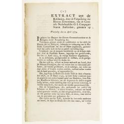
Extract uyt de Resolutien, door de Vergadering der Heeren Zeventienen, van de Generale Nederlandsche O. I. Compagnie binnen Amsterdam, genomen op Woensdag den 2 April 1774.
Contains a list of resolutions dated from 2nd April 1774 and concerning health care. Boarding crew had to be examined by the ship's surgeon. People with illnesses were to...
Place & Date: Amsterdam, 1751

Carte des découvertes fautes en 1787 dans les Mers de Chine et de Tartarie par les Frégates Françaises la Boussole et l'Astrolabe. . . ée. Feille.
La Pérouse's important large-scale of Northern Japan, Hokkaido, the Kuriles, the tip of Kamschatka, and the northern part of Korea.Showing the track of Perouse from 27 ...
Place & Date: Paris, 1797

Map of the Great Salt Lake And Adjacent Country in the Territory Of Utah. Surveyed in 1849 and 1850, under the orders of Col. J.J. Abert ...
Map of the Great Salt Lake And Adjacent Country in the Territory Of Utah. Surveyed in 1849 and 1850, under the orders of Col. J.J. Abert .. by Capt. Howard Stansbury .. a...
Place & Date: Ackerman, New York, 1852
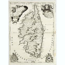
Isola di Corsica, Dedicata all' Em;mo e Rmo: Principe, il Sr. Cardinale Carpegna, Vicario di Sua Santita. . .
One of the most decorative maps of Corsica, with in the upper right, a draped fabric that bears the map's scales is dressed with two angels, one holding the cross, a coat...
Place & Date: Venise, 1692

Excelsiori (Rana N. 28 - Cent. 20).
"After so many wars and so many troubles, young Russia, in a more serene glaze all the beautiful sun of freedom you will enjoy ... ". Fascinating allegorical sa...
Place & Date: Bologna, 1905

Singapore.
Chart of Southern part of Malaysian peninsular showing good detail on of Singapore. Map with legend and scale.
Place & Date: London, 1944

A chart of the China Sea inscribed to Monsr. D'APRES de MANNEVILLETTE .. To A.Dalrymple.
Most important milestone chart is based upon the surveys made from navigational surveys by Alexander Dalrymple (1737-1808]. He was the first hydrographer of the British A...
Place & Date: Paris, ca 1775
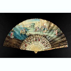
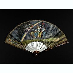
A folding fan showing Cleopatra at the Gates of Alexandria, circa 1750-1760.
The fan shows Cleopatra at the Gates of Alexandria, where she welcomes Julius Caesar who came to visit her in 48BC. Her suite is made up of soldiers and maids. The arriva...
Place & Date: English, ca. 1750-1760

Nieuwe gemeten kaart van de colonie de Berbice met der zelver plantagiën en de namen der Bezitters. . .
Re-issue of his map from 1740, without the printed list of owners, with a large added contemp. hand-colored cartouche Relaas van de rebellie, ontstaan op de plantagien in...
Place & Date: Amsterdam, ca.1763

Danubius Fluvius Europae Maximus, a Fontibus ad Ostia..
Depicts the course of the Danube River, from its sources in the Alps to the Black Sea..Because of the dimensions the map was printed from two copper plates.With two very ...
Place & Date: Amsterdam, 1638
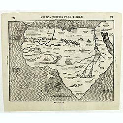
Africa Tertia pars Terrae.
This map of Africa has an unusual shape, tapering to a narrow angle in the south. Numerous rivers appear in West Africa and as tributaries to the Nile, and mountain chain...
Place & Date: Magdeburg, ca 1597

Carte des routes de poste de la Russie européenne, exécutée par ordre de S.E.M. le duc de Feltre ministre de la Guerre, ...
Post-route map on a scale of 1:2 500 000 made during the French campaign in Russia, which began June 24, 1812. With a table of the conventional signs and a table of conve...
Place & Date: Paris, Dépôt Général de la Guerre 1812

Vermakelykheden van Brabant, en deszelfs onderhoorige Landen... (2 volumes)
Topographical and iconographical work on Brabant illustrated with 1 engr. title-vignette and 190 engraved views, plans & armorial plates by J. Harrewijn, G. Bouttats ...
Place & Date: Amsterdam, P.J. Entrop, 1768

Carte du Mexique et des Etats Unis d'Amérique...
A later edition of De l'Isle's foundation map of 1703, is widely regarded as one of the most influential maps in the history of American Cartography. This updated version...
Place & Date: Paris, 1783
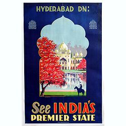
Hyderabad Dn - See Indias, premier state (Taj Mahal).
Beautiful color lithographed travel poster promoting India, more precisely the Taj Mahal.Published by Azam Steam Press Hyd. Dn.active in India.
Place & Date: India, 1930
Very fine folding fan with painting of Minerva, Juno and 2 peacocks.
Small folding fan made of double skin sheet, mounted in English style, painted with gouache and depicting Minerva and Juno sitting near each other and receiving the visit...
Place & Date: ca. 1820
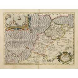
Fessae et Marocchi Regna.
One of the new maps added by Hondius, when he took over publication of the Atlas, a finely engraved and decorative map of north-west Africa, with the Canaries. With an in...
Place & Date: Amsterdam, 1630

Straat Riouw onder opzicht van de commissie tot verbetering der Indische Zeekaarten..
Very large and rare so-called Blue Back centered on the strait passing between the Riau Islands. It contains an inset map with enlarged details of Riouw Harbor on Bintang...
Place & Date: Amsterdam 1843
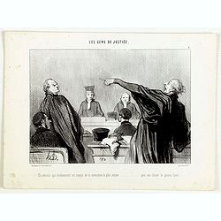
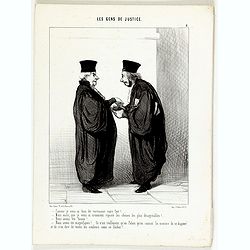
Les Gens de Justice. - Comme je vous ai bien dit vertement votre fait! . . .
Second state (of 2), with text. From "Les Gens de Justice". Text below image : - Comme je vous ai bien dit vertement votre fait! . . . - Mais aussi, je vous ai...
Place & Date: Paris, 1845-1848

Tabula Magellanica.
A map with Willem Blaeu's signature, but published by his son Joan, of South America's extremity with the Strait of Magellan and Le Maire Strait.The coastlines are depict...
Place & Date: Amsterdam, 1658
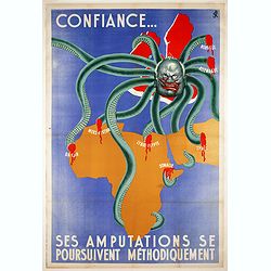
Confiance... Ses Amputations se Poursuivent Methodiquement.
Propaganda map, produced under the NAZI collaborating Vichy French regime and designed to inspire revulsion and hatred of the English among the French, while frequently d...
Place & Date: Paris, ca. 1941
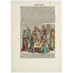
![[The creation of the world - First day]](/uploads/cache/24509-250x250.jpg)
[The creation of the world - First day]
Attractive page from the Nuremberg Chronicle, showing the creation of the world: the First Day, showing the celestial choir (God\'s creation of the angels) surrounding th...
Place & Date: Nuremberg, 12 July 1493

Chorographia Terrae Sanctae in Angustiorem. . .
Rare. Large visually rich map decorated with illustrations of the sacred objects and places of Judaism. In the bottom center is a plan of ancient Jerusalem, and the route...
Place & Date: Amsterdam, ca. 1700

Les jeunes voyageurs en Europe, ou description raisonnée des divers pays compris dans cette partie du monde.
The second edition of this fine travel companion is illustrated with 16 very decorative maps, each map surrounded by local products and specialties of the region. Include...
Place & Date: Paris, Thiériot, 1827

(Art déco gouache)
Outstanding "art deco" gouache (unsigned) from the workshop of "Robert Pichon. Ateliers de Dessin et Lithographie – 10, rue Rochechouart – Paris. The g...
Place & Date: Paris, ca. 1930

Canibales Insulae.
Rare, early Dutch nautical chart of the Caribbean from Puerto Rico southward.
Place & Date: Amsterdam, 1670
![.[Pakistan, Afghanistan]](/uploads/cache/33849-250x250.jpg)
.[Pakistan, Afghanistan]
Wood block printed Ptolemaic map of the region of present-day Pakistan and part of Afghanistan. Convoluted mountain ranges and river systems dominate the trapezoidal map....
Place & Date: Vienna, Trechsel, G., 1525 -1541

(Art-déco gouache)
Outstanding "art deco" gouache (unsigned) from the workshop of "Robert Pichon. Ateliers de Dessin et Lithographie – 10, rue Rochechouart – Paris. The g...
Place & Date: Paris, ca. 1930

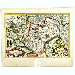
Imperii Russici et Tartariae Universae tabula novissima.
Decorative and rare map covering Russia, Tibet, China, Tartary, Korea, Taiwan and Japan prepared by J. M. Hasius. The sea between Japan and Korea is mentioned Mare Orient...
Place & Date: Utrecht, 1743

Les Gens de Justice. - Mr. l'avocat a rendu pleine justice au rare talent déployé par le ministère public . . .
Second state (of 2), with text. From "Les Gens de Justice". Text below image : - Mr. l'avocat a rendu pleine justice au rare talent déployé par le ministère ...
Place & Date: Paris, 1845-1848
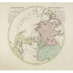
Hemisphere septentrional pour voir plus distinctement les terres arctiques. . .
Showing the Northern Hemisphere with North America, the Arctic, the Pacific, Asia and Europe after the cartographic source by the French map maker Guillaume De Isle. The ...
Place & Date: Amsterdam, c. 1740
Selling price: $1200
Sold in 2023

(Art déco gouache)
Outstanding "art deco" gouache (unsigned) from the workshop of "Robert Pichon. Ateliers de Dessin et Lithographie – 10, rue Rochechouart – Paris. The g...
Place & Date: Paris, ca. 1930
![Bressia vulgo Bresse. [colored by Van Santen]](/uploads/cache/29235-250x250.jpg)
Bressia vulgo Bresse. [colored by Van Santen]
Title cartouche with putti and surveyor with surveying instruments. Upper right-hand corner Geneva, lower left Lyon and in the center Bourg-en Bresse. Upper right-hand co...
Place & Date: Amsterdam, 1650
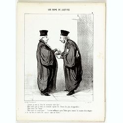
Les Gens de Justice. - Un avocat qui éviemment est rempli de la conviction la plus intime . . .
Second state (of 2), with text. From "Les Gens de Justice". Text below image : - Un avocat qui éviemment est rempli de la conviction la plus intime . . . que s...
Place & Date: Paris, 1845-1848

Russiae vulgo Moscovia dictae, Partes Septentrionalis et orientalis.
In the north the Murmansk Sea. Including the western coast of Nova Zembla. Title cartouche and two cartouches, the bottom right one showing two hunters, bears, stags etc....
Place & Date: Amsterdam, 1647
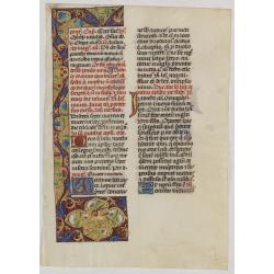
Leaf on vellum from a manuscript Brevier.
RECTO: One 3-line illuminated initial in burnished gold on colored grounds. Panel border of acanthus leaves, flowers and birds on a partly liquid gold and dark red ground...
Place & Date: Tours, c.1485

Kancheu.
Charming 18th water color on paper depicting Kancheu. Probably made by a western artist visiting China.
Place & Date: c.1750

Die Insel Formosa neu abgemessen auf Befehl Kaysers Kamhi.
One of the earliest obtainable printed map of Taiwan or Formosa Island. It was issued around 1726 to illustrate Joseph Stöcklein's [Stoecklein] compellation of Jesuit mi...
Place & Date: Augsburg, 1726
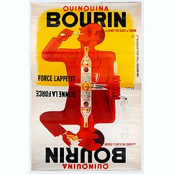
Quinquina Bourin Force l'apetit donne de la force.
Advertising poster for the French liquor brand Quinquina Bourin. Printed by De la Vasselais, Paris. Jacques Bellenger designed this original vintage poster in 1936. This ...
Place & Date: Paris, 1936
Les Gens de Justice. - Comme je vous ai bien dit vertement votre fait !
Second state (of 2), with text. From "Les Gens de Justice". Text below image : - Comme je vous ai bien dit vertement votre fait !. . . - Mais aussi, que je vous...
Place & Date: Paris, 1845-1848

Guaranty Trust Company of New York. Emprunt national 6%.n Souscrivez.
Very decorative propaganda poster with design by Mark All of Paris for "Guaranty Trust Company of New York", a JPMorgan Chase predecessor in order to promote th...
Place & Date: Paris, 1918

Carte du Canada ou de la Nouvelle France.
A later edition of Guillaume De l'Isle's map. It still includes the fictitious discoveries of Baron de Lahoutan: the legendary River Longue etc. The northwest corner of H...
Place & Date: Amsterdam, 1730

Deutschlands Postkarte begraenzt von Oesterreich, Preussen, Frankreich, Holland, Italien und der Schweiz. . .
Detailed and important post road map prepared by Ignaz Heymann. The map shows, the Low Countries, Germany, Poland, Austria, Hungary, etc.Borders in original out-line colo...
Place & Date: Triest, 1800

Il Cuscho citta principale della provincia del Peru.
A very desirable and scarce item of this decorative and early bid's-eye town-plan of the Inca city of Cuzco. Several figures shown inside the city walls and on the hillsi...
Place & Date: Lyons, 1564
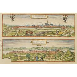
Vienna.. / Buda..
Pair of views on one sheet, the first showing the Austria capital of Vienna with fields, and figures in the foreground.Lower view shows the Hungarian capital of Budapest....
Place & Date: Cologne 1580

Fokien Imperii Sinarum Provincia undecima.
The province of Fokien lies opposite Taiwan and south of the region described in the above map. The coast is shown from Wen-zhou in the north to Fu-zhou and as far south ...
Place & Date: Amsterdam, 1660

Fly TWA (Miami).
This Miami poster was created in the early 1960's by David Klein (1918 -2005) for TWA. It depicts “hotel row” along Collins Avenue leading to the corridor of South Be...
Place & Date: 1965

Optique de St.Cloud.
This perspective view of St. Cloud comprises 6 hand colored images of the grand Bassin d'Apollon viewed through an square and two round holes cut out from the front card ...
Place & Date: Paris, ca.1845

Nuova Pianta Iconografica.. Venezia.
Precise bird's-eye town-plan of Venice, clearly depicting the city's architectural landmark, being a reduction of Ughi's 8-sheet map of 1725. There is a grid engraved ove...
Place & Date: Venice, 1818
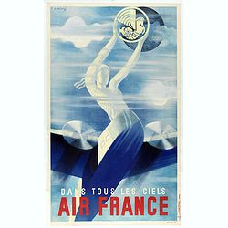
Air France dans tous les ciels.
Rare travel mini-poster made by Roger de Valerio in 1935. This example is one of the first advertising poster made by Air France. Roger de Valerio (1886 - 1951) is a Fren...
Place & Date: Imprimerie Perceval, Paris, 1936
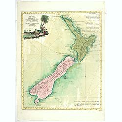
La Nuova Zelanda tracorsa nel 1769 e 1770 dal Cook commandante dell' Endeavour Vascello di S.M.Britannica.
Antonio Zatta’s map of New Zealand is not only one of the first to show the results of Cook’s voyages, but is also one of the most attractive of the islands. Consider...
Place & Date: Venise, 1778

Dominio Veneto nell' Italia.
With the Gulf of Venice. Including the towns of Cremona, Brescia, Venice, etc.As Willem Blaeu died in 1638 most of his maps are actually published by his son Joan. This m...
Place & Date: Amsterdam, 1638

Insula Huaena sive Venusia a Guiljelmo Blaeu cum sub Tychone Astronomiae operam daret, delineata.
Decorative map of the island Hvan in the Danish Sound. In the center Tycho Brahe's famous observatory Uraniborg established in 1576, under the patronage of Frederick II, ...
Place & Date: Amsterdam, 1659
Encyclopedie des Voyages. Tom 3 ASIE.
There are in this volume as many as 89 color plates, all done by the author himself. Containing dresses of people of China, Persia, Armenia, Philippines, Java, India, Tar...
Place & Date: Paris, 1796

Lo Stati Presente di Tutti i Paesi e Popoli del Mondo..
This most uncommon work provides an interesting focus on the dissemination of the outline of Japan provided by Kaempfer. Beside the description of Japan, the book include...
Place & Date: Venice, 1734
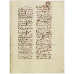
Leaf on vellum from an antiphonary.
A more than 600 years old antiphonary leaf, written in Besançon, in 1370. Musical notation on 4 bars, the staves are in red and the notes in black: numerous pen-flourish...
Place & Date: Besaçon, 1370

L'Empire de la Chine. . .
Detailed map of China, Korea and Taiwan. The large title cartouche is resplendent in the French style with musicians, a dancer, and various accouterments representative o...
Place & Date: Paris, dated 1750

Habiti delle Donne Venetiane . . .
Title page of the book Habiti delle Donne Venetiane" (Dress of Venetian Women) which consists of twenty numbered plates of ornately dressed women. This very decorati...
Place & Date: Venice, ca. 1591

Limburgensis Ducatus Tabula Nova.
Map of Limburg, prepared by the Antwerp expert in law and mathematics Aegidius Martini. After 1600 Jan Baptist Vrients acquired the stock and the plates of Ortelius' Thea...
Place & Date: Antwerp, 1606-1612
![[TAI travel poster]](/uploads/cache/44304-250x250.jpg)
[TAI travel poster]
A whimsical travel poster for "Transport Aeriens Intercontinentaux" (TAI), published in Paris in 1960, by Luc-Marie Bayle (1914-2000). The poster depicts a twin...
Place & Date: Paris, 1960
Sexta Etas Mudi. / Simon Beatus .. / Folio CCLIIII.
A very fine presentation of the circumcision of Simon (192 x 223 mm.). RECTO: a falling star, a portrait of a King and an officer wearing armour. Page from the richest il...
Place & Date: Nuremberg, 12 July 1493

Recueil de cartes géographiques pour la description de l'Indostan . . .
First French edition, the maps revised by Jean Nicholas Buache. The English original edition was published in London in 1783 by Brown under the title "Memoir of a ...
Place & Date: Paris, Poignée, an VIII = 1800

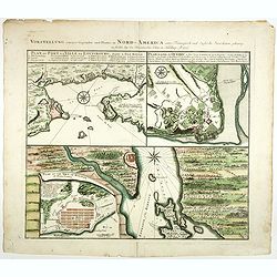
Vorstellung Einiger Gegenden und Plaetze in Nord-America unter Franzoesisch und Englische Jurisdiction Gehoerig zu Finden bey den Homaennischen Erben in Nurnberg Ao. 1756.
Three town plans on one sheet of eastern Canada, including Quebec, Louisbourg and Halifax towns which the English and French fought to conquer on the American continent f...
Place & Date: Nuremberg, 1756
![[St Peter's Square].](/uploads/cache/44864-250x250.jpg)
[St Peter's Square].
View of St Peter's Square and Vatican probably featuring a solemn blessing. The square is crowdy, the Pontifical Swiss Guard is present. A beautifully colored lithography...
Place & Date: Italy ?, 1732

De Haven en Straat von Gibraltar, Niewlyks getekend, en in`t licht gebracht door Johannes Covens en Cornelis Mortier tot Amsterdam.
Decorative map showing the siege of Gibraltar during the Spanish war of succession. This highly interesting map is richly ornated with three additional inset maps and vie...
Place & Date: Amsterdam, 1710

Tractus Littorales Guineae a Promontorio Verde usque ad sinum Catenbelae.
Chart of the West coast of Africa from Mauritania up to Angola. In top centre a very decorative title cartouche.
Place & Date: Amsterdam, 1675

Carte de L'Archipel de La Recherche a la partie Occidentale de la Terre de Nuyts. . .
A large and detailed chart of the southern West Australian coast centered on the region of Esperance and the surrounding islands.Terre de Nuyts is the name that was forme...
Place & Date: Paris 1807
![Tercia Etas Mundi. Folium XXX. [The flight of Egypt, Moses receiving the Commandments, God's Angel, Balaam and his talking donkey. ]](/uploads/cache/29854-250x250.jpg)
Tercia Etas Mundi. Folium XXX. [The flight of Egypt, Moses receiving the Commandments, God's Angel, Balaam and his talking donkey. ]
On recto two nice woodblock prints (each 128x222mm.) of The flight of Egypt and Moses receiving the Commandments.VERSO : a woodblock print of God's Angel, Balaam and his ...
Place & Date: Nuremberg, 12 July 1493
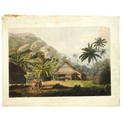
View in the island of Cracatoa.
Early view of the volcano Krakatoa (Indonesian name: Krakatau), on the Indonesian island of Rakata in the Sunda Strait, taken from "Views in the South Seas" bei...
Place & Date: London, Boydell and Co., 1808

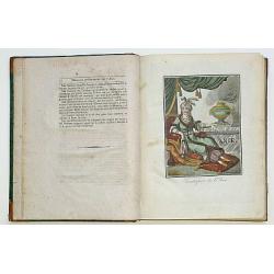
Le temple de la Mecque avec une description de tout ce qu'on y voit . . .
Fascinating engraving depicting the Muslim Kaaba at Mecca. Below the main image are two smaller vignette images of people praying. In between the two vignettes is a key (...
Place & Date: Amsterdam, 1728

Après l'Algérie et la Corse Demain se sera la France.
Anti-Communist propaganda poster, realised by the French Vichy Government and the Germans in January 1944. Propaganda hostile to the liberators playing on the fears of th...
Place & Date: Paris, 1944
Tartaria.
Published in Hondius' editions of the Mercator Atlas from 1606 onwards, showing China, Korea as an island, and the northern Pacific coast of America showing the two conti...
Place & Date: Amsterdam, 1633
Vorstellung einiger Gegende und Plaetze in Nord America.
The title of the map in English: Picture of some surroundings and towns under French and English jurisdiction. With town plans of Louisburg on Isle Royal, Quebec and Hali...
Place & Date: Nurmberg 1756
![Province de Fo-Kien. [Includes West Coast of Taiwan]](/uploads/cache/43503-250x250.jpg)
Province de Fo-Kien. [Includes West Coast of Taiwan]
Important map of Fujian Province, showing the east coast of China and the west coast of Taiwan. It shows that for the Manchu Qing, only the western half of Formosa was co...
Place & Date: The Hague, H. Scheurleer, 1737

Voyage of his majesty’s ship Alceste, along the Coast of Corea, to the island of Lewchew, with an account of her subsequent shipwreck, by John M’LEOD. Surgeon of the Alceste.
Second and best edition, with frontispiece portrait of Captain Maxwell and five fine hand-colored aquatint plates, including a plate not present in the first edition of t...
Place & Date: London, John Murray, 1818

Parte settentrionale dell' Irlanda / Irlanda parte meridionale . . .
A beautiful and flamboyantly engraved grand two-sheet map of Ireland. Embellished with two cartouches, a vessel under sail and a sea monster.The map is the product of the...
Place & Date: Venice, 1696