Browse Listings in Europe

Vue perspective de l'interieur de la Salle du spectacle de Veronne en Italie.
Showing the Opera of Verona. Optical print published Mondhare, who was a well-known publisher of optical prints, established in rue St. Jacques in Paris. In the eighteent...
Place & Date: Paris, ca. 1780

Vue perspective edu fauxbourg et du port de Scheveningue a une lieue de la Haye, en Hollande.
Optical print showing the village and harbor of Scheveningen with the church at the right, in the background the North Sea. In the background the summer residence Nieuw S...
Place & Date: Paris, ca. 1750
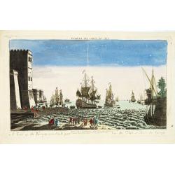
A view of the Gerzay near Iside part. / Vue du port et rade de Gerzay.
A fanciful depiction of the port of Jersey. Engraved by the French engraver Paul Angier after a design by P.Brookes and published by Robert Sayer of London, a well-known ...
Place & Date: London, ca. 1760

A view of Amsterdam taken from the Old Rampart.
So-called optical print of Amsterdam, published by Jean Mondhare after a print by Laurie and Wtitle. With captions in English and French above and belowIn the eighteenth ...
Place & Date: Paris, ca. 1760

Veduta della Piazza della SS. Nunziata, Statua Equestre di Ferdinando Primo, Fonti, e Loggie Laterali.
Lively view of Nunziata square with the statue of Ferdinand I in Florence after Giuseppe Zocchi (1711or 1717 - 1767) and engraved by B.Sgrilli. From "Scelta di XXIV ...
Place & Date: Florence, Bouchard, 1754

Le comte de Namur et partie des Duchez de Brabant. . .
Decorative map centered on Namen and including the towns of Liege, Leuven, Charleroi, Dinant, Luxemburg, etc. by François Jollain (ca. 1641 – 18 April 1704).Rare "...
Place & Date: Paris, c. 1692

Carte du Palatinat du Rhin.
Decorative "carte à figures"- map centered on Koblenz, Metz, Strasburg, Manheim and Heidelberg, with the river Rhine by François Jollain (ca. 1641 – 18 Apri...
Place & Date: Paris, ca. 1688

Les vallées du Piemont. Habitees par les Vaudois ou Berbets. . .
Detailed map of Piedmont region covering French and Italian territories. Surrounded by a French text description "Description des vallées du Piemont qu'habitent par...
Place & Date: Paris, 1690

Veue de la Ville, et du Port de Calais, di côte de la terre.
Showing the town of Calais; landscape with, in the left foreground, group of cavalrymen led by an officer and going to right, at right two soldiers walking alongside a ca...
Place & Date: Paris, ca. 1680

Carte de la France Divisée en 83 Départements et Subdivisée en districts avec les Chefs-lieux de Cantons Présentée à l'Assemblée Nationale et au Roi.
Spectacular folding wall map of France engraved by Barrier. Panels on both sides: "Tableau de la Division de la France d'après les décrets de l'Assemblée national...
Place & Date: Paris, Belleyme, 1791

De Zype. / Purmer / Wormer/ Beemster / Waterland.
Five maps on one sheet. Showing the polders of De Zype, De Purmer, De Wormer, De Beemster and a map of Waterland, including de Bylmermeer and Monnekedam. Showing the Noor...
Place & Date: Amsterdam, 1652-1658

Carro, che uà à vela Su le Piagge di Schevelingue.
Italian version of Prince Maurits' sailing carriage designed by Simon Stevin. The big sailing-carriage could seat 28 persons and could reach a speed of seven miles per ho...
Place & Date: Venice, 1707

Tableau des guerres de Frédéric le Grand: ou plans figurés de vingt-six batailles rangées, ou combats essentiels donnés dans les trois guerres de Silésie. . .
The book includes a large folded map "Tableaux des Guerres de Frédéric le Grand", showing a map of Prussia, with present-day Poland and Eastern Germany surrou...
Place & Date: Potzdam, Strasbourg, Paris, 1788

Campagne du Roi de Prusse de 1778 à 1779.
The book is illustrated with a two-sheet folding map "Carte d'une partie du Royaume de Bohême et de la Moravie ainsi que d'une partie de la Silésie". Prepared...
Place & Date: Geneva, Paris, Mérigot le jeune, 1784
Carte de la Roumanie et Pays limitrophes. Odessa. GALATZ.
Very detailed (1:750.000) map centered on Constanta, with the river Danube in Romania. Made after an Austrian map. The French Service géographique des armées was founde...
Place & Date: Paris, 1908

.Paskaart van de Mont van de Witte Zee,. Beginnende van Tiepena tot Pelitza, als mede van C. Cindenoes tot Catsnoes.
Fine sea chart of the southern part of the Barents Sea, oriented to the West. With five inset maps: - Swetenoes, de Kust van Laplandt, Lombascho, 'T Vaste Landt van Lapla...
Place & Date: Amsterdam, c.1710

Potentissimo Borussorum Regi Friderico Wilhelmo Maiestate, Fortitudine Clementia Augustissimo Hancce Lithuaniam Borussicam : in qua luca coloniis Salisburg., ad incolendum Regio nutu...
Potentissimo Borussorum Regi Friderico Wilhelmo Maiestate, Fortitudine Clementia Augustissimo Hancce Lithuaniam Borussicam : in qua luca coloniis Salisburg., ad incolendu...
Place & Date: Nuremberg, 1735

Tabula Secunda Europe (Spain & Portugal)
Wood block printed large-format Ptolemaic map of the Iberian Peninsula from the 1513 edition of Waldseemüller's Geographia.This Ptolemaic map comes from the first so cal...
Place & Date: Strasburg, 1513

Carte von West=Gallizien welche auf allerhöchsten Befehl Seiner Kaiserlich oesterreichischen und Königlich apostolischen Majestät in den Jahren 1801 bis 1804. . .
Important early map of Western Galicia, as given to Austria by the third Partition of Poland (1795). Due to its long development period, a rare map rich in detail shows t...
Place & Date: Vienna, (1808) after 1811
![[Europe, Eastern, Sarmatia, Ukraine]](/uploads/cache/33854-250x250.jpg)
[Europe, Eastern, Sarmatia, Ukraine]
Wood block printed map and one of earliest printed representation of Europe, Eastern, Sarmatia, Ukraine prepared L. Fries after Martin Waldseemüller.Based on the slightl...
Place & Date: Vienna, Trechsel, G., 1525 -1541
![.[Italy]](/uploads/cache/33856-250x250.jpg)
.[Italy]
Wood block printed map and one of earliest printed representation of Italy prepared by Martin Waldseemüller. Based on the slightly larger map from 1513 published in &q...
Place & Date: Vienna, Trechsel, G., 1525 -1541
![.[Balkan region with Austria, Croatia, Slovenia, Switzerland, etc]](/uploads/cache/33858-250x250.jpg)
.[Balkan region with Austria, Croatia, Slovenia, Switzerland, etc]
Wood block printed map and one of earliest printed representation of Balkan with Austria, Croatia, Slovenia, Switzerland, etc prepared Martin Waldseemüller. Based on the...
Place & Date: Vienna, 1525 -1541
![.[Germany and Poland]](/uploads/cache/33862-250x250.jpg)
.[Germany and Poland]
Wood block printed map and one of earliest printed representation of Germany, Poland, The Low Countries, Austria and Switzerland prepared by Martin Waldseemüller. Based ...
Place & Date: Vienna, Trechsel, G., 1525 -1541
![[Albania, Bulgaria, Europe, Eastern, Greece, Hungary, Macedonia, Romania]](/uploads/cache/33868-250x250.jpg)
[Albania, Bulgaria, Europe, Eastern, Greece, Hungary, Macedonia, Romania]
Wood block printed map and one of earliest printed representation of Albania, Bulgaria, Europe, Eastern, Greece, Hungary, Macedonia, Romania prepared Martin Waldseemülle...
Place & Date: Vienna, Trechsel, G., 1525 -1541
![.[Georgia (Republic), Sarmatia, Ukraine]](/uploads/cache/33870-250x250.jpg)
.[Georgia (Republic), Sarmatia, Ukraine]
Wood block printed map and one of earliest printed representation of Georgia (Republic), Sarmatia, Ukraine prepared by Martin Waldseemüller. Based on the slightly larger...
Place & Date: Vienna, Trechsel, G., 1525 -1541

Vue de Malthe du cote du Fort.
A so-called optical print of Valletta seen from the castle. This rare optical print shows people in typical French dresses in the foreground and placed in boats.In the ei...
Place & Date: Paris, 1798
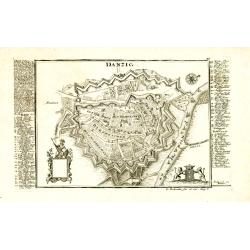
Danzig.
Detailed and rare plan of Danzig with extensive key in German.
Place & Date: Augsburg, 1730

Russie Européenne . . .
Detailed map of European part of Russia, including Finland and Lapland.Gilles Robert de Vaugondy (1688–1766), also known as Le Sieur or Monsieur Robert, and his son, Di...
Place & Date: Paris, ca. 1753

Carta geographica generalatus carlostatuensiscum adgacentibus confinis turcicis et venetis...
Fine and rare manuscript map of Croatia and the Dalmatian coast from the early eighteenth century. Oriented to the south the map details the Venetian, Austrian and Turkis...
Place & Date: Venice , c. 1700

Polonia regnum et Silesia ducatus.
Very decorative map of Poland embellished with two cartouches and two coats of arms surmounted by cherubs and female figures. Showing the region from the Oder east to Pod...
Place & Date: Amsterdam, 1638

Die Stadt Narva. . .
An early of the town of Narva, located at the eastern tip of Estonia, on the Russian border.From the uncommon Hamburg edition "Viel Vermehrte Moscowitische und Pers...
Place & Date: Hamburg, 1696

A Map of the Environs of Constantinople Drawn from a great number of accurate astronomical & geographical manuscripts and printed documents, by A. Arrowsmith 1801 and 1804.
Arrowsmith’s large and detailed map of the Ottoman Empire and the Black Sea, with Cyprus, Crete and the Greek Islands in the Mediterranean Sea, Albania, Bosnia and Herz...
Place & Date: London, No.10 Soho Square, 4th September 1804

Carte de L'Empire d'Alemagne par P. Duval. . .
Uncommon map of Germany and the eastern part of Poland. In upper right corner a dedicational cartouche with coat of arms and dedication to Saint-Laurens.
Place & Date: Paris, 1676
![[Set of 6 maps] Charta öfver Storfurstendömet Finland på Friherre S. G. Hermelins Anstalt och Omkostnad. Sammandragen och författad af C. P. Hällström. Philos. Magister och Auscultant i Kongl. BergsColl. 1799.](/uploads/cache/34482-250x250.jpg)
[Set of 6 maps] Charta öfver Storfurstendömet Finland på Friherre S. G. Hermelins Anstalt och Omkostnad. Sammandragen och författad af C. P. Hällström. Philos. Magister och Auscultant i Kongl. BergsColl. 1799.
This is the beautiful set of key map and separate maps of Samuel Gustav Hermelins map of Finland. The maps have been engraved by Fredrik Akrel, a very skilled and product...
Place & Date: Källa: J.Strang & E.- S. Harju: Suomen karttakirja 1799

The Crimea, chiefly from surveys made by order of the Russian government. . .
Map of Crimea and the Sea of Azov. In lower right corner two inset maps showing Sebastopol inlet and harbour and a second one with the Black Sea. This second maps shows t...
Place & Date: London, 1854

Loudunois. Laudunum / Mirebalais.
Two maps on one sheet. Centered on Loudun and Mirebeau. Showing lower left cartouche putti playing with grapes.German text on verso.
Place & Date: Amsterdam, after 1636

Pascaart van Europa alsmede een gedeelte vande Kust van Africa. . .
An eye-catching chart of the entirety of Europe's coastline from northern Russia to Yugoslavia in the south. Also showing the West Coast of Africa as far as the Cape-Verd...
Place & Date: Amsterdam, after 1666
Selling price: $2375
Sold in 2023

Quarta pars Brabantiae cujus caput Sylvaducis.
A good and dark impression in strong original colors.The third state. The coat of arms of Brabant and 's-Hertogenbosch appears on the map. The municipal arms in the colum...
Place & Date: Amsterdam, 1645

Pascarte van Europa Beginnende vande Canael tot aen Spitbergen, en van Ysland tot aen Nova Zemla . . .
An eye-catching chart of northern Europe with a coastline from northern Russia to the Dutch English Channel in the south. Good detail on Iceland. North to the top.In the ...
Place & Date: Amsterdam, after 1666

(upper sheets only) Asia According to the Sieur D'Anville Divided into its Empires, Kingdoms and States Showing the European Settlements in the East Indies and all the New Discoveries made by the Russians, the Dutch and the English . . . 1772
Highly detailed map of Russia, including Turkey, China and Korea. Based on the cartography of the famous French cartographer Jean Baptiste Bourguignon d' Anville. Only th...
Place & Date: London, 1772