Browse Listings in Europe > Netherlands

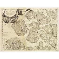
Over deese grietenije.. Eerste van Wester Goo..
Very decorative map centered on Menaam, Marsum and Boxum from the Uitbeelding der Heerlijkheit Friesland prepared by Schotanus. With decorative title cartouche lower righ...
Place & Date: Leeuwarden, F.Halma, 1718

Amsterdam Capitale de la Hollande.
A panoramic of Amsterdam seen from 't IJ. Set within a decorative border, printed from a separate plate. Rare.
Place & Date: Leiden, 1720

Episcop. Ultraiectinus.
A very detailed map based on Utrecht. Scale cartouche held by a surveyor. Based on the map by B.F.van Berckenrode (1620-21) and engraved by the master engraver Evert Sijm...
Place & Date: Amsterdam, 1630-1632

Fossa Sanctae Mariae.
Detailed map of part of the country between rivers Rhine and Meuse showing a canal to be dug between 1626 and 1628 between Rheinberg in Germany and Venlo. A deficiency of...
Place & Date: Amsterdam, 1645

Zelandia Comitatus.
Based on the map by Van Deventer. For the first time a road connection between Flushing, Middelburg and Arnemuiden is shown. Mercator pays much attention to the area of s...
Place & Date: Amsterdam, 1630

Het Friessche Doolhoff, het beruchte dorp Molk-Worren
Uncommon map made in 1718 by Johannes Hilarides, principal at the Latin School in Bolsward.. Probably the only printed plan of a Frisian village of that time. The map was...
Place & Date: Amsterdam, 1705

Fossa Sanctae Mariae.
Detailed map of part of the country between rivers Rhine and Meuse showing a canal to be dug between 1626 and 1628 between Rheinberg in Germany and Venlo. A deficiency of...
Place & Date: Amsterdam, 1645

Comitatus Zutphania.
A very detailed map of this area, including Arnhem, Nijmegen, Zutphen, Groenlo, etc. First imprint, from a Latin edition of the scarce Atlas Appendix.
Place & Date: Amsterdam, 1637

De Zype. / Purmer / Wormer/ Beemster / Waterland.
Five maps on one sheet. Showing the polders of De Zype, De Purmer, De Wormer, De Beemster and a map of Waterland, including de Bylmermeer and Monnekedam. Showing the Noor...
Place & Date: Amsterdam, 1652-1658

Nieuwe kaart van het Koningrijk der Nederlanden. . .
Uncommon map of the Netherlands prepared by J.S. Smulders and P. H. Witkamp and lithographed by Z.M. den Koning in the Hague. Dated.Showing The Kingdom of the Netherlands...
Place & Date: The Hague, 1874

Tabula Episcopatuum Leodiensis et Coloniensis. . .
Rare issue of Cornelis Danckert's attractive map of Limburg, shows the area of Cologne, Mainz, Trier, Jülich, Mons, Antwerp and Liege in Belgium.Decorative title cartouc...
Place & Date: Amsterdam, 1700

Kollumer land En het Nieuw Kruys land de vijfde gritenije van Oostergoo . . .
Very detailed map of "Kollumer land En het Nieuw Kruys land de vijfde gritenije van Oostergoo" in Friesland prepared by Bernardus Schotanus Steringa. Centered o...
Place & Date: Leeuwarden, F. Halma, 1718

Gezicht van het Admiraliteits-Magazyn en Scheeps Timmerwerf.
Formerly the V.O.C. warehouse and arsenal for the Admiralty of Amsterdam, now-a-days the Scheepvaartmuseum (Maritime Museum). Taken from the "Atlas of Amsterdam"...
Place & Date: Amsterdam, 1780
Contado di Zelanda..
A most attractive and decorative map by Vincenzo Coronelli. An elaborate title cartouche garlanded with intertwined flowers and dedicated to Vincenzo Caualli. The remarka...
Place & Date: Venice 1692

Tabula comitatus Hollandiae. . .
Fine map of the provinces of North and South Holland. In upper left hand corner an inset with the islands of Texel and Vlieland.
Place & Date: Augsburg 1760

Slusa, Teutonicae Flandriae opp. . . (Sluis)
Bird'eye view of the town of Sluis.From the greatest publication in this genre!. The Civitates was compiled and written by George Braun, Canon of Cologne Cathedral. Braun...
Place & Date: Cologne, 1580

Provincie Noord-Braband.
Decorative and uncommon costume plate lithographed by Desguerrois & Co. and published by Frans Buffa & Zonen in Amsterdam. 12 illustrations of Brabant costumes: 1...
Place & Date: Amsterdam, 1857

s'Lants Zee-Magazyn en Scheeps Timmer-werf.
Decorative view of the back yard of the formerly the V.O.C. warehouse and arsenal for the Admiralty of Amsterdam, now-a-days the Scheepvaartmuseum (Maritime Museum).The p...
Place & Date: Amsterdam, 1694

Kaart van Zeeland.
Fine map of the province of Zeeland, with the fortified cities are highlighted in red. Isaac Tirion was born in Utrecht ca. 1705. He came to Amsterdam ca. 1725. Tirion pu...
Place & Date: Amsterdam, 1747

Vue perspective edu fauxbourg et du port de Scheveningue a une lieue de la Haye, en Hollande.
Optical print showing the village and harbor of Scheveningen with the church at the right, in the background the North Sea. In the background the summer residence Nieuw S...
Place & Date: Paris, ca. 1750

Tabula Bergarum ad Zomam Stenbergae et novorum ibi operum.
The map gives an outline of the Scheldt from Bergen op Zoom to Antwerp, with all the ramparts built between 1622 and 1627.
Place & Date: Amsterdam, 1647

Circoscrizione delle Provincie ecclesiastiche e Diocesi nei regni del Belgio, ed Olanda (Tav LXI)
This large-format map showing Belgium and Holland with its different dioceses. The map is finely engraved and beautifully colored and was prepared by Girolamo Petri, a la...
Place & Date: Rome, 1858

Henna ardera deel. De vijfde Grietenije van de Wester goo. . .
Very detailed map of "Henna ardera deel. De vijfde Grietenije van de Wester goo" in Friesland prepared by Bernardus Schotanus Steringa. With decorative title ca...
Place & Date: Leeuwarden, 1718

Vue générale d'Amsterdam.
A so-called optical prints, showing Amsterdam seen from the IJ. A lively scene with extensive shipping. To the left the headquarters of the V.O.C., nowadays the Maritime ...
Place & Date: Paris, ca. 1750

Vue du village de Maarsen en Hollande.
Showing the river Vecht at the town of Maarsen. Published by Jacques Chereau, who was a well-known publisher of optical prints, established in rue St. Jacques in Paris. I...
Place & Date: Paris, ca. 1750

Perspective du Voorhout, promenade publique de La Haye.
Showing the Voorhout in The Hague. Likely published by Mondhard, who was a well-known publisher of optical prints, established in rue St.Martin in Paris. In the eighteent...
Place & Date: Paris, ca. 1750

Provincie Noord-Braband. / Breda, de Langstraat. . .
Decorative and uncommon custume plate lithographed by R. de Vries and published by Frans Buffa & Zonen in Amsterdam. A group of 4 women from the area of Baronie van B...
Place & Date: Amsterdam, 1857

Het Klooster ten Hage (Marienhage Eindhoven)
Very rare lithography of the ruin of the monastery of Ten Haghe in Eindhoven. Lithographed by M.Mouret, published in "oud-Nederland en de uit vroegere dagen overgebl...
Place & Date: Nijmegen, 1837-1846

Het West Indisch Huys.
A decorative print of the West Indian House , the headquarters of the WIC, a place for meeting, trading and storage of spices and ship equipment. The maps and charts were...
Place & Date: Amsterdam, J. van Meurs, 1663
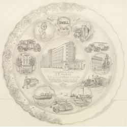
Shell : 9 Februari 1911-1951.
Decorative design-drawing in lead pencil offered to mr. J.E. Talens for his 40 years jubilee at the Shell foundation : Aangeboden aan J. E. Talens ter gelegenheid van zij...
Place & Date: Gouda, ca. 1951

Nieuwe kaart van het oostelykste deel van Holland. . .
Detailed map covering the area of Gouda, Iisselstein, s'Hertogenbosch, Zevenbergen, Dordrecht.
Place & Date: Amsterdam, 1749

A Perspective View of the Admiralty Office, Dock-Yard, Storehouses &c. at Amsterdam.
Decorative engraving giving good detail of the intense activity in the Amsterdam dockyards.Engraved for BANKES's New System of Geography
Place & Date: Amsterdam, 1780

DELFT. Delphium urbs Hollandiae cultissima. . .
A bird's-eye view of the town of Delft. From the first Dutch translation of Guicciardini's description of the Netherlands. In this town-plan, three buildings, still domin...
Place & Date: Amsterdam, 1612

Het stadhuis, van vooren.
The former Amsterdam Town Hall, now the Royal Palace. Copper engraving by Frans de Bakker after Reinier Vinkeles (1741-1816).From the well-known description of Amsterdam ...
Place & Date: Amsterdam, 1765

Das Hertzogthum Braband. . .
Charming map of the Dutch and Belgium province of Brabant. With a fine cartouche.
Place & Date: Leipzig, 1749

Ruremunda Gelriae opp.
A bird's eye town-plan of the town of Roermond. From the first Dutch translation of Guicciardini's description of the Netherlands.
Place & Date: Amsterdam, 1612

D' Admiralyteyts Huys - La maison de l'Amirauté.
Decorative print of the "D'Admiralyteits Huys", Het Prinsenhof, of the Dutch East India Company VOC. Located at the Oudezijds Voorburgwal 195-199, Amsterdam.
Place & Date: Amsterdam, ca. 1700

Oost-Indis Zee Magazyn - Arçenal des Indes Orientalis.
Decorative view of the East Indian Arsenal, now-a-says the Maritime Museum.
Place & Date: Amsterdam, ca. 1700

Vue du village de Maarsen en Hollande.
Showing the river Vecht at the town of Maarsen. Published by Jacques Chereau, who was a well-known publisher of optical prints, established in rue St. Jacques in Paris. I...
Place & Date: Paris, ca. 1750

A view of Amsterdam taken from the Old Rampart.
So-called optical print of Amsterdam, published by Jean Mondhare after a print by Laurie and Wtitle. With captions in English and French above and belowIn the eighteenth ...
Place & Date: Paris, ca. 1760