Browse Listings

Provincie Noord-Braband. / Breda, de Langstraat. . .
Decorative and uncommon custume plate lithographed by R. de Vries and published by Frans Buffa & Zonen in Amsterdam. A group of 4 women from the area of Baronie van B...
Place & Date: Amsterdam, 1857

Prospectus Castelli Boxtel.
One of the earliest views of the Castle of Boxtel. Engraved by Henricus Cause. With a description in Latin, French and Dutch.
Place & Date: Amsterdam, 1695

Prospectus veteris castelli Graviae.
One of the earliest views of the ancient Castle of Grave. Engraved by Casper Bouttats. With a description in Latin, French and Dutch.
Place & Date: Amsterdam, 1695
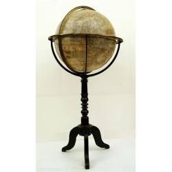
Globe terrestre d'après les découvertes..
Attractive and large (height 112cm) library globe by a prominent Paris globe maker, with a brass meridian circle, horizon ring and hour ring, supported by four brass quad...
Place & Date: Paris, ca. 1885
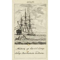
Muitery op het O:I: Comp. schip Barbestein in Duins.
Anonymous engraving of a mutiny of the VOC ship Barbestein .
Place & Date: Amsterdam c.1790

Dongerdeel.. De vierde grietenij van Ooster Goo.
Very decorative map centred on Dokkum, Metzerwier and Pasens from the Uitbeelding der Heerlijkheit Friesland prepared by Schotanus. With decorative title cartouche lower ...
Place & Date: Leeuwarden, F.Halma, 1718

Over deese grietenije.. Eerste van Wester Goo..
Very decorative map centered on Menaam, Marsum and Boxum from the Uitbeelding der Heerlijkheit Friesland prepared by Schotanus. With decorative title cartouche lower righ...
Place & Date: Leeuwarden, F.Halma, 1718

Vue Interieure de la Bourse Royale à Londres.
So-called optical print of the London stock exchange. Daumont was a well-known publisher of optical prints, established in Paris. In the eighteenth and nineteenth centuri...
Place & Date: Paris, 1760

Nieuwe kaart van 't Koninckryk Bengale. . .
Rare map Bangladesh with the Ganges delta, including Calcutta. Giving great detail with trade routes, European trade settlements, etc. Prepared by Joh. Van Leenen who was...
Place & Date: Amsterdam, 1726

Isola del Giapone e penisola di Corea.
A most attractive and decorative map by Vincenzo Coronelli. An elaborate central title cartouche garlanded with intertwined flowers and dedicated to the Rev.de Fontaine o...
Place & Date: Venice, 1692

Guyana, Surinam, Amapa.
Very rare Ottoman printed map of Guyana, Suriname and Amapa. With Trinidad, an inset map of the mouth of the Rivers Essequibo, Courantyne, Suriname with Paramaribo.From C...
Place & Date: Üsküdar (Istanbul), 1803
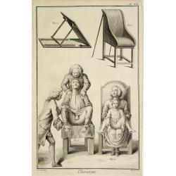
Chirurgie, plate XII
Showing medical chair and physician at work from the medical section of Diderot's Encyclopaedia. Engraved by Bernard after a design of Goussier. Very important work as it...
Place & Date: Paris 1779
-250x250.jpg)
Vues du port de Llivourne. (set of 6 prints)
Sought-after complete suite of 6 engravings by S[tefano] Della Bella [1610-1664]. in a second state (of 2).Della Bella was born in Florence in 1610, and studied the art ...
Place & Date: 1654-1655
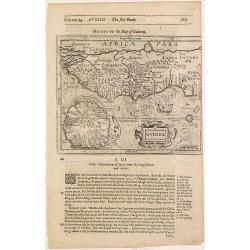
Guinea.
Samuel Purchas' edition of the Mercator/Hondius Atlas Minor . Map of Guinea published in his famous collection of voyages His Pilgrimes . With descriptive text in English...
Place & Date: London, 1645

Kasteel Croij.
Decorative lithography of the castle of Croij.
Place & Date: Den Haag, 1880

Het Klooster ten Hage (Marienhage Eindhoven)
Very rare lithography of the ruin of the monastery of Ten Haghe in Eindhoven. Lithographed by M.Mouret, published in "oud-Nederland en de uit vroegere dagen overgebl...
Place & Date: Nijmegen, 1837-1846

Carte qui contient..Iles & Terres..L'Amerique..Jamaique..
Eight maps on one sheet. From Chatelain's Atlas Historique et Méthodique . Including maps of Bermuda, Jamaica, New England with Long Island, Carolina, Chesapeake and Del...
Place & Date: Amsterdam 1728

Ruremunda Gelriae opp.
A bird's eye town-plan of the town of Roermond. From the first Dutch translation of Guicciardini's description of the Netherlands.
Place & Date: Amsterdam, 1612
Carte du Katay ou Empire de Kin. . .
The map is of interest for the use of Mer de Corée, for the sea between Korea and Japan .Fine map of Korea and China's Yellow Sea. Complete title in top: Carte du Katay ...
Place & Date: Paris, 1750

Tablaeu de l'Univers premiere partie/ .. seconde partie.
Uncommon and interesting manual containing a double hemisphere world map (with fine outer decoration and showing an imagined great sea in West America, easily the size of...
Place & Date: Luik, Belgium, 1784

Bern in der Schweitz.
Very fine panoramic of Bern. With a numbered key (1-25) of principal buildings in town.
Place & Date: Augsburg, 1740

Il regno della China detto presentente Catay e Magnin. . .
A rare and decorative Italian map of China and Japan, with Japan closely modelled on the indented Cardim outline and Hokkaido, called Yuppi , shown as an Asian peninsula....
Place & Date: Rome, 1682

La Florida/ Peruviae Auriferae regionis Typus/ Guastecan.
The Chaves map of Florida is a prime example of an explorer's map since it records the recent discoveries of Cabeza de Vaca, De Soto, and Moscoso. The map revealed little...
Place & Date: Antwerp, 1592

Insulae Americanae in Oceanus Septentrionali cum Terris..
General map of the West Indies extending from Virginia to the mouth of the Orinoco, and destined to be copied in various shapes by many other publishers. Title cartouche ...
Place & Date: Amsterdam, 1647

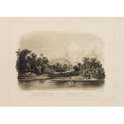
Forest scene on the Tobihanna Alleghany Mountains.
Original aquatint engraving for Travels in the Interior of North America between 1832-34 . Engraved by L.Weber. The finest work on American Indian life and the American F...
Place & Date: London/Paris/Coblenz, 1839
Waschinga Sahba's Grab.. (Wakonda Creek.)
Original aquatint engraving for Travels in the Interior of North America between 1832-34 . Engraved by Ch. Vogel. The finest work on American Indian life and the American...
Place & Date: London/ Paris/ Coblenz, 1839
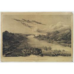
Gezigt op de haven en de baai van Nagasaki.
A very rare birds-eye view showing Deshima and Nagasaki bay. Von Siebold was born in Würtzburg, in Germany, and worked for the Dutch government as a doctor in Java. In J...
Place & Date: Leiden 1832-1852

Turcici Imperii Imago.
The map shows the Ottoman Empire with Turkey, Black Sea, Mediterranean Sea, Arabia and North Eastern Africa. The map is decorated with a title cartouche and a portrait of...
Place & Date: Amsterdam, 1629

Vue du sperbe Temple de St.Sophie .. a Constantinople.
A fanciful depiction of the Aya Sofya in Istanbul. In the eighteenth and nineteenth centuries there were many popular speciality establishments in Paris, Augsburg and Lon...
Place & Date: Paris, 1800

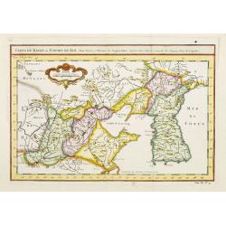
Tabula Episcopatuum Leodiensis et Coloniensis. . .
Rare issue of Cornelis Danckert's attractive map of Limburg, shows the area of Cologne, Mainz, Trier, Jülich, Mons, Antwerp and Liege in Belgium.Decorative title cartouc...
Place & Date: Amsterdam, 1700
De gelegenheyt van t'paradys ende t'landt van Canaan..
Very attractive map, showing the location of Paradise. Two vignettes depict the Temptation of Adam and Eve, and their Expulsion from the Garden of Eden. Nicolaes Visscher...
Place & Date: Amsterdam, 1664

Constantinopolis.
A spectacular woodcut panorama of the ancient city of Constantinople, proporting to show the pre-Turk city (for example naming St Sophia). (235x522mm).One of the earliest...
Place & Date: Nuremberg, 12 July 1493

Arabie.
Uncommon miniature map of the Arabian peninsula, from Pierre Duval's La Geographie Universeille dated 1676. Following his Cartes de géographie in 1657, Pierre Duval publ...
Place & Date: Paris, 1676
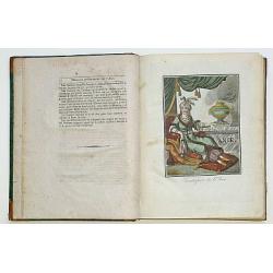
Encyclopedie des Voyages. Tom 3 ASIE.
There are in this volume as many as 89 color plates, all done by the author himself. Containing dresses of people of China, Persia, Armenia, Philippines, Java, India, Tar...
Place & Date: Paris, 1796

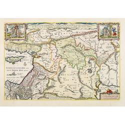
Landgraviatus Alsatiae tam superioris..
Alsace, in the far north-eastern corner of France, stands out from other French wine regions thanks to its strong Franco-Germanic influences. Alsace is the only French wi...
Place & Date: Nurenberg, 1710

Hemisphaerium Orbis Antiqui cumzonis circulis. . .
A chart showing the eastern hemisphere, including north eastern coast of Australia with, superimposed, climatic zones and planetary details. Surround by most decorative s...
Place & Date: Amsterdam, 1708

L'Enfance de Paul et Virginie.
Fine engraving of Paul and Virginie.Paul et Virginie (or Paul and Virginia) is a novel by Jacques-Henri Bernardin de Saint-Pierre, first published in 1787. The novel's ti...
Place & Date: Paris, ca. 1790
![De Texel Stroom met de gaten vant Marsdiep. [with] Caarte van De Mase ende het Goereesche Gat.](/uploads/cache/12097-250x250.jpg)
De Texel Stroom met de gaten vant Marsdiep. [with] Caarte van De Mase ende het Goereesche Gat.
Two decorative charts on one sheet, one depicting Texel and the entrance of the Zuider Zee with an inset showing the north coast of West-Friesland, the other depicting th...
Place & Date: Amsterdam, 1660

Cust van Hollant Tussen de Maes ende Texel.
Uncommon chart of the coast of Holland, including the southern tip of Texel. East at the top. Two fine compass cards, soundings and a large Bree Veerthien offshore.Piete...
Place & Date: Amsterdam, 1666

Pascaerte Van't Westelyckste der Middelandsche Zee. . .
An eye-catching chart of the western part of the Mediterranean Sea.Pieter Goos (ca. 1616-1675) was one of the most important cartographer, engraver, publisher and print s...
Place & Date: Amsterdam, 1666