Browse Listings in Europe
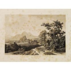
Salzbourg.
Uncommon and decorative lithography published by Carl Johan Billmark and printed by Lemercier in Paris, 55 rue de Seine, the leading firm in Europe at that time. From: It...
Place & Date: Paris, c.1859

Carte historique de la France, et l'Angleterre depuis la naissance de Jésus-Christ jusqu'à l'an 1700, qui contient en abrégé les événements principaux de ces royaumes pendant l'empire romain. . .
A rare wall map showing a chronological tree of French and English historical events from the year of the birth of Christ until 1700. The map is prepared by Jérôme Andr...
Place & Date: Paris, c. 1721

Launa vulgo Laun Bohemiae civitas.
Bird's-eye views of Louny in Bohemia by G. Hoefnagel. The copperplate was made for Braun and Hogenberg's town book. However there the print has been transformed by the en...
Place & Date: The Hague, 1700

Tschopau.
Very decorative and rare panoramic of Tschopau.The engraver and publisher of prints, Mrs. Anna Beek of the Hague, enlarged the print and mounted it on larger paper: she ...
Place & Date: The Hague, ca. 1700

Volna.
Very decorative and rare panoramic town-view of Volna. We have more Anna Beek prints available.The engraver and publisher of prints, Mrs. Anna Beek of the Hague, enlarg...
Place & Date: The Hague, ca. 1700

Strasborcs In der Vocker Marckt.
Very decorative and rare panoramic town view of Völckermarckt in Kärten.The engraver and publisher of prints, Mrs. Anna Beek of the Hague, enlarged the print and mounte...
Place & Date: The Hague, ca. 1642

Statt Talbe an der Saal.
Very decorative and rare panoramic town view of Calbe a.d. Saale, Bez Magdeburg .The engraver and publisher of prints, Mrs. Anna Beek of the Hague, enlarged the print and...
Place & Date: The Hague, ca. 1642

Czaslaw.
Very decorative and rare panoramic of Czaslaw, Caslav, Tschslau in Böhmen.The engraver and publisher of prints, Mrs. Anna Beek of the Hague, enlarged the print and moun...
Place & Date: The Hague, ca. 1642

Wittstocs.
Very decorative and rare panoramic of Wittstock, Bez. Potsdam.The engraver and publisher of prints, Mrs. Anna Beek of the Hague, enlarged the print and mounted it on larg...
Place & Date: The Hague, ca. 1642

Leisnig.
Very decorative and rare panoramic town view of Leisnig a.d. Freiberger Mulde.The engraver and publisher of prints, Mrs. Anna Beek of the Hague, enlarged the print and m...
Place & Date: The Hague, ca. 1642

ANTIBES, Ville et Port de Mer de Provence, sur la Mer Mediterranée.
Early plan of Antibes. From his "Introduction à la fortification".
Place & Date: Paris, 1693

St Tropez.
Early plan of St.Tropez. From his "Introduction à la fortification".
Place & Date: Paris, 1693

Kollumer land En het Nieuw Kruys land de vijfde gritenije van Oostergoo . . .
Very detailed map of "Kollumer land En het Nieuw Kruys land de vijfde gritenije van Oostergoo" in Friesland prepared by Bernardus Schotanus Steringa. Centered o...
Place & Date: Leeuwarden, F. Halma, 1718

Comitatus Zutphania.
A very detailed map of this area, including Arnhem, Nijmegen, Zutphen, Groenlo, etc. First imprint, from a Latin edition of the scarce Atlas Appendix.
Place & Date: Amsterdam, 1637

Ducatus Limburg.
A very rare issue of this map of Limburg. Cornelis Danckerts II. copied the folio map of H.Hondius.The publisher's address was placed in the lower right-hand corner. The ...
Place & Date: Amsterdam, 1636

Bowles's new four-sheet map of England and Wales. . .
Bowles's new four-sheet map of England and Wales: Comprehending all the Cities, Boroughs, Market and Sea-Port Towns, Villages, Lakes, Rivers, Forests, Ruins, Canals, and ...
Place & Date: London, 1801

Grande Pologne et Prusse avec les frontières de la Misnie, Lusace, Moravie et Lithuanie.
Detailed map of Poland and Prussia. Published by Pieter van der Aa who published a.o. "Naauwkeurge versameling der gedenkwaardigste zee- en land-reysen", a seri...
Place & Date: Leiden, 1729

Venise. 1700
Extremely rare panoramic broad sheet panoramic town-view of Venice with underneath in letter press a description of the town's history. The view measures more than 1 mete...
Place & Date: Paris, 1699

Landgraviatus Alsatiae tam superioris..
Alsace, in the far north-eastern corner of France, stands out from other French wine regions thanks to its strong Franco-Germanic influences. Alsace is the only French wi...
Place & Date: Nurenberg, 1710
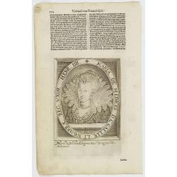
Maria De Medices D. G Galliae et Navarrae Reg. Uxor Henr. IIII.
The engraving depicts a half length oval portrait of Marie de' Medici, queen consort of France .Nicolaes de Clerck (de Klerc) was active as engraver and publisher in Delf...
Place & Date: Amsterdam, Cloppenburch, 1621

Citta, porto, e rada di Brest, e . . . Nella Bretagna . . .
A beautiful and rare map of Bretagne. In top right an inset with the town of Brest.The remarkable Vincenzo Coronelli (1650-1718), encyclopaedist, geographer, inventor and...
Place & Date: Venice, 1690

Languedoc - Foix Roussillon.
Very decorative, informative map of Languedoc - Foix Roussillon region in south eastern France. Including the towns of Carcassonne, Montpellier, Albi, Toulouse, etc.The m...
Place & Date: France, 1943

Guyenne - Gascogne.
Very decorative, informative map of Guyenne and Gascogne region in France. The map is filled with buildings, animals, figures and two locals. With a large compass rose in...
Place & Date: France, 1943

Le Duché d'Aiguillon Tracé Par le Sr. Du Vall.
Home of the "Cahors” This AOC is the most famous of the sub-regions and home to the popular variety Malbec. These inky wines have been adored for centuries, especi...
Place & Date: Amsterdam, 1650

Premislia celebris russiae civitas.
RARE only included in part VI of his town book. Bird's-eye of Przemysl in Poland. Frans Hogenberg (1535 Mechelen - Cologne 1590) was a copper engraver and etcher. Georg B...
Place & Date: Cologne, 1618

Isola d'Oleron, nella piaggie occidentali della Francia.
A beautiful and rare map showing île d'Oleron.The remarkable Vincenzo Coronelli (1650-1718), encyclopaedist, geographer, inventor and Doctor of Theology, was citizen of ...
Place & Date: Venice, 1690

Het Canaal tusschen Engeland en Vranciick.
An eye-catching chart of the Channel.Pieter Goos (ca. 1616-1675) was one of the most important cartographers, engravers, publishers and print sellers of Amsterdam. His wi...
Place & Date: Amsterdam, after 1666

The town & harbour of Sevastopol with the batteries & approaches. . .
Rare colored linen backed map showing the harbour and town of Sevastopol, with soundings. In upper left corner a inset map (65x150mm) of the Black Sea. In bottom part a l...
Place & Date: London, March 27th, 1854

Forteresse Ile Ste Marguerite.
Nice drawing of a stronghold Ste Marguerite. The Île Sainte-Marguerite is the largest of the Lérins Islands, about half a mile off shore from the French Riviera town of...
Place & Date: France, Provence, after 1960

Moscovia urbs Metropolis totius Russiae Albae.
Detailed bird's-eye town-plan of Moscow from Janssonius' rare townbook. With a key (1-20) to important spots in town. The verso has French text and originates from Jansso...
Place & Date: Amsterdam, 1657

Nostre Dame de Lorette.
A very RARE panoramic of Lorette and the church, including a numbered legend in both lower corners.The plate is numbered in black pencil in upper right corner.Published ...
Place & Date: Paris c.1720

Tabula Ducatus Brabantiae.
Detailed map orientated west to the top.
Place & Date: Amsterdam, 1680

Veue de la Ville, et du Port de Calais, di côte de la terre.
Showing the town of Calais; landscape with, in the left foreground, group of cavalrymen led by an officer and going to right, at right two soldiers walking alongside a ca...
Place & Date: Paris, ca. 1680

s'Lants Zee-Magazyn en Scheeps Timmer-werf.
Decorative view of the back yard of the formerly the V.O.C. warehouse and arsenal for the Admiralty of Amsterdam, now-a-days the Scheepvaartmuseum (Maritime Museum).The p...
Place & Date: Amsterdam, 1694

Gezicht van het Admiraliteits-Magazyn en Scheeps Timmerwerf.
Formerly the V.O.C. warehouse and arsenal for the Admiralty of Amsterdam, now-a-days the Scheepvaartmuseum (Maritime Museum). Taken from the "Atlas of Amsterdam"...
Place & Date: Amsterdam, 1780

Carte d'Europe . . .
Rare. Uncommon and decorative wall map of Europe, prepared by Clouet. With superb decoration including a wonderful rococo border with vignettes describing historical scen...
Place & Date: Paris, 1785-1788

A Perspective View of the Admiralty Office, Dock-Yard, Storehouses &c. at Amsterdam.
Decorative engraving giving good detail of the intense activity in the Amsterdam dockyards.Engraved for BANKES's New System of Geography
Place & Date: Amsterdam, 1780

Vue du Magazin de la Compagnie des Indes Orientales. . .
So-called optical print of the formerly the V.O.C. warehouse and arsenal for the Admiralty of Amsterdam, now-a-days the Scheepvaartmuseum (Maritime Museum).In the eightee...
Place & Date: France, 1780
![Venecie. [Venice] Foliu XLIIII](/uploads/cache/29716-250x250.jpg)
Venecie. [Venice] Foliu XLIIII
A very fine of Venice (192x525mm.) Verso a view of Padua. Schedel's view of Venice is one of the earliest obtainable views of the city. The view is based on the view of ...
Place & Date: Nuremberg, 12 July 1493

LA RUSSIE NOIRE ou POLONOISE qui Comprend les PROVINCES DE LA RUSSIE NOIRE de VOLHYNIE et de PODOLIE divisées en leurs Palatinats Vulgairement Connües sous le Nom D'VKRAINE ou PAYS DES COSAQUES.
Very rare map of the Ukraine and Poland, prepared by Sanson in 1675 in a third state, published by the heirs of Sanson, in Paris in 1706. The imprint changed to: Par les ...
Place & Date: Paris, 1706

La marca d'Ancona. Marchia Anconitana Picaenum olim dicta. . . Romae apud Joannem Orlandini formis Rome 1604.
A re-issue of the plate by Vicentium Luchinù of 1564 now with the address of Orlandini and the dates 1602 / 1604.Collector's item. A unique opportunity to acquire a fine...
Place & Date: Rome, 1604

Plan de la Baye de Ville Franche et de celle de St. Souspir.
An attractive chart centered on the Mediterranean. With scale and large compass-rose. Dated 1727, with the privilege of the King. From : Recueil des Plusieurs plans des p...
Place & Date: Marseille, 1730
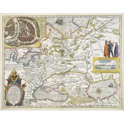
Tabula Russiae ex autographo, quod delineandum curavit Foedor filius Tzaris Boris desums... - Domino regionum Iueriae Kartalinie et Groefiniae Tzari etc: dedicata ab Heselo Gerardo M.DC.XIIII
A re-issue, by Willem Blaeu, of Hessel Gerritsz' rare and influential map of Russia. Dutch text on verso, extending west to east from Emden to Aspachan and north to south...
Place & Date: Amsterdam, 1635

Il Governo di Guascogna con porzione del Governo di Guienna.
Rare regional map of France of the Périgord, Guienne, Gascogne and the Béarn published by Carli Pazzini in Siena.
Place & Date: Siena, 1792

Gouvernement general de Champagne. . .
Fine map of Champagne with a decorative title and scale cartouche.Alexis-Hubert Jaillot (1632-1712), was a French cartographer. He joined the Sanson heirs and redrew Nico...
Place & Date: Amsterdam, 1692

Le comte d'Artois dresse sur les memoires les plus nouveaux. . .
Map showing the north of France, showing St Omer, and Arras, etc. The map notes Nicolas Sanson as the mapmaker and claims that the map was published by Alexis-Hubert Jail...
Place & Date: Amsterdam, 1693
![Bressia vulgo Bresse. [colored by Van Santen]](/uploads/cache/29235-250x250.jpg)
Bressia vulgo Bresse. [colored by Van Santen]
Title cartouche with putti and surveyor with surveying instruments. Upper right-hand corner Geneva, lower left Lyon and in the center Bourg-en Bresse. Upper right-hand co...
Place & Date: Amsterdam, 1650

ANNA IWANOVNA - Anna Ioannovna imperatricea i camoderschiza wserossinskaja (rossice). Anna Joannowna imperatrix totius Russiae
Extremely rare half portrait print of Anna Ivanovna (7 February [O.S. 28 January] 1693, Moscow – 28 October [O.S. 17 October] 1740) reigned as Duchess of Courland from ...
Place & Date: St. Petersburg, 1743

ELISABETH I. - Elisabet imperatriza wseros sinskaja petra welikago dscherj (rossice). Elisabetha imperatrix. Omnium Russiarum Petri. Magni. Filia.
Extremely rare half portrait print of Elizaveta Petrovna (29 December [O.S. 18 December] 1709 – 5 January 1762 [O.S. 25 December 1761] ), also known as Yelisavet and El...
Place & Date: St. Petersburg, 1743

FJODOR JOANNOWITSCH - Feodor Ioannowitsch zar i camoderschez wserossinskij (rossice). Feodor Ioannowicz tzaar et autocrator totius Russiae Joann Alexiewicz tzaar et autocrator totius Russiae.
Extremely rare half portrait print of Czar Fyodor I Ivanovich (31 May 1557 – 16/17 January 1598) was the last Rurikid Tsar of Russia (1584 - 1598), son of Ivan the Terr...
Place & Date: St. Petersburg 1743

ALEXEI I. - Alexei Michailowitsch zar i camoderschez wserossinskij (rossice). Alexei Michailowicz tzaar et autocrator totius Russiae.
Extremely rare half portrait print of Czar Alexei Michailowicz..Aleksey Mikhailovich Romanov ( 9 March 1629 (O.S.) – 29 January 1676 was the Tsar of Russia during some ...
Place & Date: St. Petersburg, 1743

IWAN ALEXEJEWITSCH - Ioann Alexejewitsch zar i camoderschez wserossinskij (rossice).Joann Alexiewicz tzaar et autocrator totius Russiae.
Extremely rare print of Czar Ivan Alexejewitsch, who was the brother of Peter the Great.Johann Stenglin was a well known engraver, born at Augsburg in 1715, he studied un...
Place & Date: St. Petersburg 1743

Paris, Lutetia, Parisii, Ville Capitale du Royaume de France.
View of Paris seen from the hill "Belleville based on that of Merian (1616) but updated with the new gates Saint-Denis and Saint-Martin. With a key 1-78 and A-Z. Sur...
Place & Date: Paris, after 1676

Nice Vue prise audessus de Montalban.
Beautiful view of Nice from the book "l'Italie à vol d'oiseau".
Place & Date: Paris, 1850

Langwasser Stanislau Neu Brandenburg Mei 1942 Juni 1945
Map met reproducties van crayontekeningen van Krijgsgevangenschap in Langwasser, Stanislau en Neu-Brandenburg, Mei 1942 -juni 1945.Uitgegeven april 1948 door het Minister...
Place & Date: Den Haag, April 1948

Typus Galliae Veteris, Ex conatib' Geograph. Abrah.Ortelii.
A very decorative map with countries of ancient France prepared by Abraham Ortelius and published by one of the most famous map publishers, Willem Blaeu.
Place & Date: Amsterdam, 1645

Group of 21 watercolors of scenes in Iceland, included are vulcanos like Eyjafjallajokull, Öræfajökull, etc.
A group of water colors made during visits of the artist F. de Boungne to Iceland, among them are contemporary artistic impressions of the now world-famous volcano Eyjafj...
Place & Date: Iceland, 1933-1944

Belgica Foederata. . .
Decorated with a cartouche showing the coats of arms of Zeeland, Holland, Utrecht, Friesland, Groningen and Overijssel. T.C. Lotter married M. Seutter's daughter in 1740 ...
Place & Date: Augsburg, ca.1760

Souvenirs des Pyrénées. Vues prises aux environs des eaux thermales de Bagnères-de-Bigorre, Bagnères-de-Luchon, Cauteretz, Saint-Sauveur, Barèges, Les-eaux-Bonnes, Les-Eaux-Chaudes & Pau.
The thermal baths Bagnères de Bigorre, Bagnères de Luchon, Cauteretz, Saint-Sauveur, Barèges, Les Eaux-Bonnes and Pau in the Pyrenees. Beautiful collection of 24 litho...
Place & Date: Pau, A.Basset, ca. 1860

Angliae, Scotiae, et Hiberniae, sive Britannicar : Insularum descriptio.
A rare and ornate map with inset portraits of James First, Henry Prince of Wales Princess Anne of Denmark.Janssonius acquired the copperplate of van den Keere's 1604 Brit...
Place & Date: Amsterdam, 1621

Danubius Fluvius Europae Maximus, a Fontibus ad Ostia..
Depicts the course of the Danube River, from its sources in the Alps to the Black Sea..Because of the dimensions the map was printed from two copper plates.With two very ...
Place & Date: Amsterdam, 1638

Desciption de lopulente et manifique ville de Venise.
Extremely rare panoramic view of Venice and neighboring islands (Murano, Burano, Torcello and Mazorbo), clearly depicting the city's architectural landmark. The surroundi...
Place & Date: Paris, 1646

Profil de la renomée ville et port d'Emstredam cappitalle des estats de Hollande.
Extremely rare panoramic town-view of Amsterdam seen from the river IJ.Exceptional bright, sharp example.The print is skillful copy of the print of Matthieu Merian, now w...
Place & Date: Paris, 1647
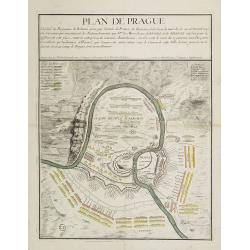
Plan de Prague.
Rare and separately published plan of Prague published by Joan Baptista Nolin with the address à l'enseigne de la Place des Victoires et chez le Sr. Humblot rue St. Jacq...
Place & Date: Paris, ca. 1742

Imperii Russici et Tartariae Universae tabula novissima.
Decorative and rare map covering Russia, Tibet, China, Tartary, Korea, Taiwan and Japan prepared by J. M. Hasius. The sea between Japan and Korea is mentioned Mare Orient...
Place & Date: Utrecht, 1743

France Physique.
A thematic map of France divided in the areas related to the rivers Rhine, La Seine, La Loire, La Garonne, du Rhone and the coasts of the Atlantic and Mediterranean. From...
Place & Date: Paris, 1874

Madrid.
Extremely rare town-view of Madrid. Engraved by Francesco Ambrosi.With a second title in lower part "Madrid Ciudad Capital Del Reyno D'Espana y real corte de los rey...
Place & Date: Bassano del Grappa, c.1780
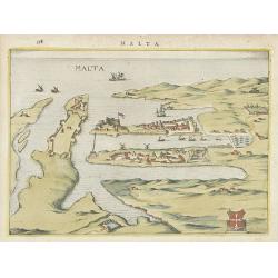
Malta.
Attractive birds-eye town-view of Valetta on Malta. With coat of arms lower right. With page number 398 in top. Latin text on verso.
Place & Date: The Netherlands ? 1650

Plan de la ville, cite universite et fauxbourgs de Paris comme il est jourddhuy. . .
Detailed town-plan of Paris.Top left and bottom right and left cartouches decorated with views of the top left, Notre Dame, Palace of Orleans, Sorbonne and Val de Grâce,...
Place & Date: Paris, 1694

Les Villes forts et châteaux de Malte capitale de l'isle de ce nom. Dessignée sur le lieu par un Ingr du roy.
A very decorative and extremely rare town-view of Valetta, including a numbered legend in lower part. Published by Jacques Chereau, (1688 - 1776). Engraved by Aveline and...
Place & Date: Paris, ca.1750
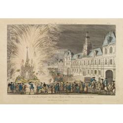
Vue d'un Feu d'Artifice tiré devant l'Hotel de Ville en réjouissance de la Paix.
Optical view, illustrating a fireworks display in front of the Paris city hall.In the eighteenth and nineteenth centuries there were many popular speciality establishment...
Place & Date: Paris 1760

Beschrijvinge vande de zee Cuften va Vlanderen en Picardien. . .
DUTCH TEXT EDITION. A detailed chart of the coast of Flanders and Normandy decorated by a large colorful baroque title cartouche, and the coat of arms of Flanders with a ...
Place & Date: Leiden, Plantijn, 1585

Paris.
A spectacular panoramic view of Paris, with legends numbered from 1-70 in French. With the title in a banderol.After a design by Friedrich Bernhard Werner (1690-1776) who...
Place & Date: Augsburg, ca. 1740

Poloniae, Lituaniaeq descriptio.
Fine general map of Poland. Rare; the second plate appearing in the post-1595 edition of the Theatrum. Only used until 1612.Based on the now-lost map of Waclaw Grodecki. ...
Place & Date: Antwerp, 1612
![Dépt. De L'Aude. N°10. [ Carcassonne ]](/uploads/cache/27089-250x250.jpg)
Dépt. De L'Aude. N°10. [ Carcassonne ]
Map of the Aude region, centered on the town of Carcassonne. Reaching to the right till the Mediterranean.Lovely map from one of the last decorative atlases of the ninete...
Place & Date: Paris, A. Combette, 1852

Carte de la Coste de La Rochelle a Brouaige et de l'Isle d'Oleron Observee par le S.r de Chattillon ingenieur du Roy.
Map of the island of Oléron, with an inset in lower left corner showing the route of an English fleet to La Rochelle. At the time of mapping the area was a stronghold of...
Place & Date: Paris, 1627

Plan de la Ville et Port d'Antibes.
An attractive chart centered on the Mediterranean. With a scale and large compass-rose. Dated 1727, with the privilege of the King. From : Recueil des Plusieurs plans des...
Place & Date: Marseille, 1730

Picardie Meridionale Le Cambresis et leurs Environs.
Map showing the region of Picardie in Northern France. Including the towns of Abbeville, Amiens, Compiegne, Soisson, Chambray, etc.
Place & Date: Paris, 1737
![[Crimea]. Carte de la Cromée.](/uploads/cache/25719-250x250.jpg)
[Crimea]. Carte de la Cromée.
Mapmaker, Captain Jan Hendrik van Kinsbergen (1735-1819). Published by H. Friesman in 1787. This map first appeared in 1776 and was the first Russian map of the newly ann...
Place & Date: Amsterdam, H. Frieseman, 1787
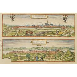
Vienna.. / Buda..
Pair of views on one sheet, the first showing the Austria capital of Vienna with fields, and figures in the foreground.Lower view shows the Hungarian capital of Budapest....
Place & Date: Cologne 1580