Search Listings matching "east-sea"
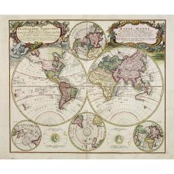
Planiglobii Terrestris - Mappe-Monde...
Word map in double hemisphere. In center two smaller hemispheres of the north and south pole are shown. Two interesting diagrams depict the earth as it would be seen from...
Place & Date: Nuremberg, 1746
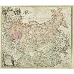
Imperii Russici et Tartariae Universae tam majoris Afiaticæ quam minoris et EuropæTabula.
The map is of interest for the use of Mere Orientale Minus Corea for the sea between Korea and Japan.Decorative map covering Russia, Tibet, China, Tartary, Korea, Taiwan ...
Place & Date: Nuremberg, 1739
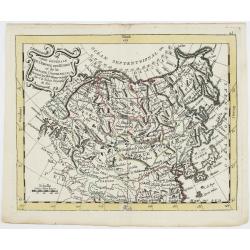
Carte Générale de l'Empire des Russes et de la Tartarie Universelle.
Rare map of Tartary and Russia, including Korea and Japan prepared after J.B.Nolin and published by Monhare for his Atlas Général a l'usage des colleges et maisons d'ed...
Place & Date: Paris, 1783
Selling price: $400
Sold in 2023

Globe Terrestre Didié et Présénté a Monseigneur le Comté Maubec de Brancas...
Terrestial globe dated 1741. Complete title "Globe Terrestre Didié et Présénté a Monseigneur le Comté Maubec de Brancas Par Jacque Hardy. Dressé sur ...
Place & Date: Paris, dated 1741

Asia.
Uncommon map of Asia. Engraved by Marco di Pietro.The map is of interest for the use of G. di Corea, for the sea between Korea and Japan.Published by Carlo Antonio Barbie...
Place & Date: Milan, 1807
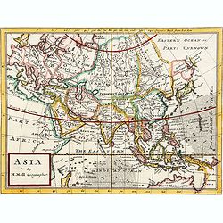
Asia By H.Moll Geographer.
Detailed map of Asia. From his "Atlas minor: or a new and curious set of sixty-two maps. . .", which was first published in 1729 and reprinted in 1732, 1736.The...
Place & Date: London, 1736

Carte du Katay, ou Empire de Kin : pour servir a l'Histoire de Jenghiz Khan, raportée dans l'Histoire generale des voyages, tirée de l'Angloise.
The map is of interest for the use of East Sea, the sea between Korea and Japan, here called "Mer de Corée".Fine map of Korea and China's Yellow Sea. Complete ...
Place & Date: Paris, 1750
Selling price: $450
Sold in 2023

Carte des Isles du Japon Esquelles est remarque la Route..
This uncommon map of Japan, which is on a fairly large scale, contains comments about the nature of the country. For instance, Ocsaqui (Okazaki, near Nagoya) is said to h...
Place & Date: Paris 1679

Nouvelle Mappa Monde.
State 2 of this fine double hemisphere world map, from an unusual perspective, with a "Mer de L'Ouest" or "Sea of the West". Paris is located at the c...
Place & Date: Venice, 1776 - 1784

Matching set of four wallmaps of America, Asia, America, Europe.
Rare and decorative set of four wall maps published by Louis Charles DESNOS ( fl.1750-1770), including a border with vignettes describing native scenes. Each panel is acc...
Place & Date: Paris, 1760-1761