Search Listings matching "east-sea"
![[Set of five maps] Carte Générale de la Terre ou Mappe Monde](/uploads/cache/41145X-250x250.jpg)
[Set of five maps] Carte Générale de la Terre ou Mappe Monde
Rare and decorative set of five wall maps of the world and the four continents, prepared by Clouet, in very fine bright contemporary coloring. Each map ca. 965 x 1230 mm ...
Place & Date: Paris and Cadiz, Mondhare, 1785-1793

La China e Giapone.
Uncommon map of China, Korea, Japan and Taiwan (I.Formosa), only one town labeled, Tayoan. Very strange shape for Japan.The map is of interest for the use of Mar di Corea...
Place & Date: Italy, ca. 1800

Map of China.
Showing China, Taiwan and Korea, divided into provinces with the main cities marked. The map is of interest for the use of Sea of Corea, the sea between Korea and Japan, ...
Place & Date: London, 1804

Siberie ou Russie Asiatique, Tartarie Chinoise, Pays des Eluts et Isles du Japon.
Map of the Kamchatka peninsula, Russian Far East., Korea, Japan, with Hokkaido labeled "Terre del Jeso".By C. F. Delamarche, successor of Robert de Vaugondy, Ge...
Place & Date: Paris, 1794 - 1806

Asia.
Uncommon map of Asia. Engraved by Marco di Pietro.The map is of interest for the use of G. di Corea, for the sea between Korea and Japan.Published by Carlo Antonio Barbie...
Place & Date: Milan, 1807

Charte von China und den angränzenden Ländern und Völkerschaften so wie den letzten Kaiser Tschien-Long. . .
Uncommon map of China on a scale of ca. 1:6,000,000. The map's complete title is “Charte von China und den angränzenden Ländern, und Völkerschaften so wie sie dem le...
Place & Date: Parague, 1812
Selling price: $400
Sold in 2023
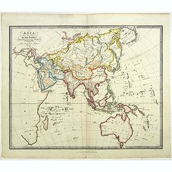
Asia for the Elucification of the Abbe Gaultier's Geographical Games.
An unusual Children's educational map of Asia, Countries depicted in different colors, and with only some physical features engraved, like mountain ranges and rivers, som...
Place & Date: London, 1823

Siberia & Central Asia.
This map covers the eastern section of Russia as well as China, Japan, Korea, India and Tibet. The map is of interest for the use of Sea of Corea, the sea between Korea a...
Place & Date: Boston, 1835

NEWTON'S New and Improved TERRESTRIAL GLOBE Accurately delineated from the observations of the most esteemed NAVIGATORS AND TRAVELLERS to the Present Time. . .
A very impressive Victorian 20-inch Library globe showing the "Gulf of Corea". On an exceptionally carved mahogany tripod stand with scrolling acanthus legs ter...
Place & Date: London, January 1, 1867