Browse Listings in World Maps

Nous vaincrons parce que nous sommes les plus forts. Souscrivez aux bons d'armement.
We win because we are the strongest. Support good armaments". Quote by the French Prime Minister Paul Reynaud. French wartime propaganda poster. colored world map - ...
Place & Date: Pars, ca. 1939
![Summa philosophiae quadripartita, de rebus dialecticis, moralibus et metaphysicis . . [ With unrecorded world map ]](/uploads/cache/28639-250x250.jpg)
Summa philosophiae quadripartita, de rebus dialecticis, moralibus et metaphysicis . . [ With unrecorded world map ]
On page 107 a finely copper engraved world map (88x84mm.) Paradigma Terrae Plagas 4.ac 12. Ventorum situm indicans., centered on Europe and Africa, with parts of America,...
Place & Date: Leiden, Peter Rigaud, 1626

Hemisphaerium Orbis Antiqui cumzonis circulis. . .
A chart showing the eastern hemisphere, including north eastern coast of Australia with, superimposed, climatic zones and planetary details. Surround by most decorative s...
Place & Date: Amsterdam, 1708

Nova Orbis Tabula in Lucem edita A.F.de Wit.
According to Shirley, De Wit's map is one of the most attractive of its time. The brilliant scenes in the corners combine images of the four seasons, the elements, and th...
Place & Date: Amsterdam, 1680
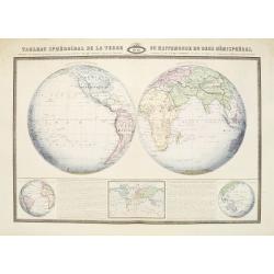
Tableau Sphéroïdal de la Terre ou Mappemonde en deux Hémispères. . .
Large steel engraving presenting the whole World in different projections, namely showing the convexity of the Earth.At the bottom a temperature contour map of the world ...
Place & Date: Paris, 1860

Nouvelle Mappa Monde.
State 2 of this fine double hemisphere world map, from an unusual perspective, with a "Mer de L'Ouest" or "Sea of the West". Paris is located at the c...
Place & Date: Venice, 1776 - 1784

Matching set of four wallmaps of America, Asia, America, Europe.
Rare and decorative set of four wall maps published by Louis Charles DESNOS ( fl.1750-1770), including a border with vignettes describing native scenes. Each panel is acc...
Place & Date: Paris, 1760-1761
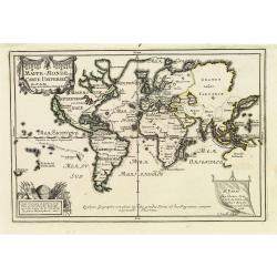
Mappe-Monde ou carte Universelle. . .
Uncommon world map in Mercator's projection, which first appeared in De Fer's Atlas Curieux.Showing California as an island. Engraved by C.Inselin.Shows the explorer's ro...
Place & Date: Paris, 1705

Secunda etas mundi. Folium XIII.
Schedel's world map was based on the cartographic system of Claudius Ptolemy, the great second-century AD geographer whose scholarship formed the foundation for map produ...
Place & Date: Nuremberg, 12 July 1493
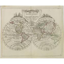
Mappe-Monde ou Description du Glôbe Terrestre Assujettie aux Observs Astronoms.
Double hemisphere map with a curious shape for Australia, from Atlas moderne portatif composé de vingt-huit cartes sur toutes les parties du globe terrestre .. A l'usage...
Place & Date: Paris, Prudhomme, Levrault, Debray, 1806