Browse Listings
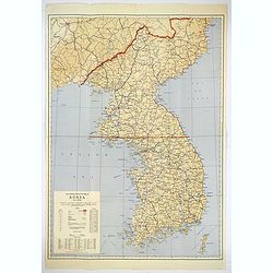
Official War map of Korea.
A large folding map of Korea published in the year of the outbreak of the Korean War, published by the Rand McNally Company. The map is extremely detailed and features a ...
Place & Date: America, ca 1950

L'Homme A La Boule.
Satirical print in which Count Otto von Bismarck balances on the world with one spurred foot entering France, and wearing only his underpants which are marked with the Ge...
Place & Date: Paris, 1870-1871

Circoscrizione delle Provincie ecclesiastiche e Diocesi nei regni del Belgio, ed Olanda (Tav LXI)
This large-format map showing Belgium and Holland with its different dioceses. The map is finely engraved and beautifully colored and was prepared by Girolamo Petri, a la...
Place & Date: Rome, 1858

London in Miniature With The Surrounding Villages. An Entire New Plan In which the Improvements both present and intended are actually reduced, by permission, from the surveys of the Several Proprietors. . .
Hand-coloured engraved map, dissected and mounted on linen, orange publishers label on one side, extending west to east from Kensington to East India and Greenwich Dock a...
Place & Date: London, 1821

Voyage of his majesty’s ship Alceste, along the Coast of Corea, to the island of Lewchew, with an account of her subsequent shipwreck, by John M’LEOD. Surgeon of the Alceste.
Second and best edition, with frontispiece portrait of Captain Maxwell and five fine hand-colored aquatint plates, including a plate not present in the first edition of t...
Place & Date: London, John Murray, 1818

Novus de Leone Belgico eiusq topographia atq. Historica descriptione liber (…). Rerumque in Belgio maxime gestarum, inde ab anno Christi M.D.LIX. Usque ad annum M.D.LXXXVII perpetua narratione continatus.
ENLARGED EDITION, with 207 (of 208) engravings of a famous eyewitness account of the Dutch Revolt, with the famous "Leo Belgicus" map, here in its second state...
Place & Date: Cologne, Gerardus Campensis for Frans Hogenberg, 1588
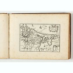
Carte Generalles des Royaumes & Provinces, de la haute et basse Allemagne, Reveües et Corigées, par le Sr. Tassin, Geographe Ordinaire de Sa Ma.té.
Illustrated with 51 (of 52) maps of The Netherlands, Belgiem, Germany, France, Poland, Bohemia...Christophe Tassin, who was active from 1633 till 1655, was appointed 'roy...
Place & Date: Paris, [Sébastien Cramoisy], 1633

Slusa, Teutonicae Flandriae opp. . . (Sluis)
Bird'eye view of the town of Sluis.From the greatest publication in this genre!. The Civitates was compiled and written by George Braun, Canon of Cologne Cathedral. Braun...
Place & Date: Cologne, 1580

Germaniae Nova ac Accurata Descriptio.
This "carte à figures"- map covers the Low Countries, Germany, Poland, Switzerland and Austria. Overall a very good copy of this excellently engraved, uncommon...
Place & Date: Amsterdam, 1642

Siberia & Central Asia.
This map covers the eastern section of Russia as well as China, Japan, Korea, India and Tibet. The map is of interest for the use of Sea of Corea, the sea between Korea a...
Place & Date: Boston, 1835