Browse Listings in Europe > Netherlands

Donger deel.. derde grietenije van Ooster Goo. . .
Very decorative map of the area north of Dokkum from the Uitbeelding der Heerlijkheit Friesland prepared by Schotanus. With decorative title cartouche lower right mention...
Place & Date: Leeuwarden, F.Halma, 1718

Episcop. Ultraiectinus.
A very detailed map based on Utrecht. Scale cartouche held by a surveyor. Based on the map by B.F.van Berckenrode (1620-21) and engraved by the master engraver Evert Sijm...
Place & Date: Amsterdam, 1630-1632

Fossa Sanctae Mariae.
Detailed map of part of the country between rivers Rhine and Meuse showing a canal to be dug between 1626 and 1628 between Rheinberg in Germany and Venlo. A deficiency of...
Place & Date: Amsterdam, 1645

Zelandia Comitatus.
Based on the map by Van Deventer. For the first time a road connection between Flushing, Middelburg and Arnemuiden is shown. Mercator pays much attention to the area of s...
Place & Date: Amsterdam, 1630

Amsterdam Capitale de la Hollande.
A panoramic of Amsterdam seen from 't IJ. Set within a decorative border, printed from a separate plate. Rare.
Place & Date: Leiden, 1720

Het Friessche Doolhoff, het beruchte dorp Molk-Worren
Uncommon map made in 1718 by Johannes Hilarides, principal at the Latin School in Bolsward.. Probably the only printed plan of a Frisian village of that time. The map was...
Place & Date: Amsterdam, 1705
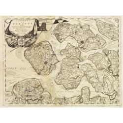
Contado di Zelanda..
A most attractive and decorative map by Vincenzo Coronelli. An elaborate title cartouche garlanded with intertwined flowers and dedicated to Vincenzo Caualli. The remarka...
Place & Date: Venice 1692

Nieuwe kaart van het Koningrijk der Nederlanden. . .
Uncommon map of the Netherlands prepared by J.S. Smulders and P. H. Witkamp and lithographed by Z.M. den Koning in the Hague. Dated.Showing The Kingdom of the Netherlands...
Place & Date: The Hague, 1874

Slusa, Teutonicae Flandriae opp. . . (Sluis)
Bird'eye view of the town of Sluis.From the greatest publication in this genre!. The Civitates was compiled and written by George Braun, Canon of Cologne Cathedral. Braun...
Place & Date: Cologne, 1580

Comitatus Zutphania.
A very detailed map of this area, including Arnhem, Nijmegen, Zutphen, Groenlo, etc. First imprint, from a Latin edition of the scarce Atlas Appendix.
Place & Date: Amsterdam, 1637