Browse Listings in Europe > Germany > German Provinces

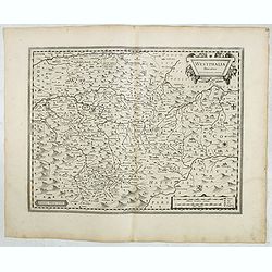
Franciae orientalis../ Monasteriensis et osnaburgensis..
From 'Theatrum Orbis Terrarum [Atlas of the Whole World]' published in Antwerp. French text on verso.The map of Frankenland is prepared by Sebastian Rotenhan (1478-1532) ...
Date: Antwerp, c.1574

Typus Frisiae Orientalis à Dullarto
One of the most decorative maps of East Frisia and its important shipping center of Emden and the Watten Islands, from the cartography of Ubbo Emmius, a local cartographe...
Date: Amsterdam, ca. 1624

Coloniensis Archiepisscopatus.
Extremely rare first edition of this beautiful map of Cologne and Dusseldorff.Jodocus Hondius Jr. planned to produce a new modern atlas less dependent on the Mercator pla...
Date: Amsterdam, 1629
![Tabula electoratus Brandenburgici, Meckelenburgi, et maximae partis Pomeraniae, ex variis, famosissimisq[ue] auctoribus summo studio concinnata. . .](/uploads/cache/29543-250x250.jpg)
Tabula electoratus Brandenburgici, Meckelenburgi, et maximae partis Pomeraniae, ex variis, famosissimisq[ue] auctoribus summo studio concinnata. . .
Uncommon "carte à figures"- map engraved by the master engraver Abraham Goos and published by Claes Jansz. Visscher (1587-1652). Showing the area of Brandenbur...
Date: Amsterdam, 1630

Palatinatus Rheni Nova et Accurata Descriptio.
Early state (1630) of Visscher's "carte à figures"- map of the German Rhine River Valley. Inset views of Frankfurt am Main, Mainz, Speyer, Worms and Heidelberg...
Date: Amsterdam, 1630
Westphalia Ducatus.
Originally engraved for Jodocus Hondius II, at his death in August 1629 this map was, among 39 other copper plates,purchased by Willem Blaeu who deleted Hondius' name and...
Date: Amsterdam, 1634
Selling price: ????
Please login to see price!
Sold in 2025

Franconiae nova descriptio.
Second state of this early map of Franken, including Regensburg, Heidelberg, Marburg and Hof. In lower part decorative cartouches and upper right a dedication to Franz vo...
Date: Amsterdam, after 1646

Hassia Landgraviatus.
Centered on the town of Kassel.
Date: Amsterdam, 1650

Carte du Palatinat du Rhin.
Decorative "carte à figures"- map centered on Koblenz, Metz, Strasburg, Manheim and Heidelberg, with the river Rhine by François Jollain (ca. 1641 – 18 Apri...
Date: Paris, ca. 1688

Oost-Frise, ou Le Comté d'Embden . . .
Fine map of East Friesland with a decorative cartouche and small scale of miles.Alexis-Hubert Jaillot (1632-1712), was a French cartographer. He joined the Sanson heirs a...
Date: Amsterdam, 1692

Tabula Episcopatuum Leodiensis et Coloniensis. . .
Rare issue of Cornelis Danckert's attractive map of Limburg, shows the area of Cologne, Mainz, Trier, Jülich, Mons, Antwerp and Liege in Belgium.Decorative title cartouc...
Date: Amsterdam, 1700

Landgraviatus Alsatiae tam superioris..
Alsace, in the far north-eastern corner of France, stands out from other French wine regions thanks to its strong Franco-Germanic influences. Alsace is the only French wi...
Date: Nurenberg, 1710

Nieuwe Kaart van de Westfaalse Kreits..
Isaac Tirion was born in Utrecht ca. 1705. He came to Amsterdam ca. 1725. Tirion published a number of important books, many of which are still in demand for their intere...
Date: Amsterdam, 1745

Dynastiae Comitat. Schoenburgici Penig, Remissa, Rochsburg, Wechselburg In Clientela Elect: Saxon Glaucha, Hartenstein, Lichtenststein, Walkenburg. . .
A very uncommon and superbly decorative map of Lower Saxony, the region southwest of Dresden. Including the towns of Rochlitz, Geringswalde, Mittweida, Frankenberg, Chemn...
Date: Augsburg, 1750

La Saxe Contenant le Routes et les postes. . .
Fine post-route map of Saxony in Germany with a splendidly engraved title cartouche. The map is centered on Leipzig. George Louis Le Rouge was active between 1740 and 178...
Date: Paris, 1756
Selling price: ????
Please login to see price!
Sold in 2025
