Search Listings matching "pacific" in America

Maris Pacifici.
From the rare Dutch text edition of the Theatrum of which according to van den Broecke only 100 copies are printed.This was the first printed map to be devoted solely to ...
Place & Date: Antwerp, 1598
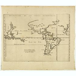
Descripcion de las Yndias Ocidentalis.
Rare early general map of America, the Pacific Ocean and the Eastern part of Asia. Showing "Meridiano de la demarcacion porla parte oscidental" - and "... ...
Place & Date: Amsterdam, Michel Colin, 1622

Americae Nova Tabula.
The delineation of the coast and the nomenclature on both the Pacific and Atlantic coasts are basically Spanish in origin and follow the maps of Ortelius and Wytfliet. To...
Place & Date: Amsterdam, 1645

Mar del Zur, Hispanis Mare Pacificum.
Janssonius' fine chart of the Pacific including the west coast of America with California shown as an island, Japan and a small Australian coastline. This is the earliest...
Place & Date: Amsterdam, 1650
![[Printed on silk] Nova Totius Americae Sive Novi Orbis Tabula, Auct. Hugo Allardt.](/uploads/cache/48420-250x250.jpg)
[Printed on silk] Nova Totius Americae Sive Novi Orbis Tabula, Auct. Hugo Allardt.
Hugo Allard’s ca. 1661 map of the Americas, showing California as an island printed on silk. This separately issued map printed on paper is quite rare on the market. T...
Place & Date: Amsterdam, 1661
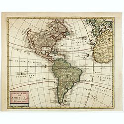
Nieuwe kaart van America.
An attractive map of both the Americas, by one of the leading mapmakers in 18th century Amsterdam. Isaak Tirion (d. 1769) was a Amsterdam publisher. His "Nieuwe en b...
Place & Date: Amsterdam, 1765

Le Isole di Sandwich delineate sulle osservazioni del Cap Cook.
FIRST EDITION on laid paper. Cassini’s splendid map depicts Sandwich islands, old name for Hawaii islands, at the end of the eighteenth century. The splendid cartouche ...
Place & Date: Rome, 1798
![A Toopapaoo of a Chief, with a priest making his offering to the Morai, in Huoheine. [Huaheine - the Society Islands]](/uploads/cache/30045-250x250.jpg)
A Toopapaoo of a Chief, with a priest making his offering to the Morai, in Huoheine. [Huaheine - the Society Islands]
A view of a chief's raised burial chamber in Huaheine, Society Islands, taken from "Views in the South Seas" being a very important and early view depicting sce...
Place & Date: London, Boydell and Co., 1808

Carte des Iles Hawaii.
A lovely small map of the complete chain of Pacific islands known today as the Hawaiian islands, from Dumont d'Urville's atlas "Voyage pittoresque autour du Monde.&q...
Place & Date: Paris, 1834

Entrée des forêts de la rivière Sedger. . .
Exquisite contemporary colored lithograph of Sedger's river in the Chili, with as seen by Dumont D'Urville's, with Indians. Drawn by Louis Le Breton, lithographed by Bich...
Place & Date: Paris, 1846

Rivage du port Saint-Nicolas.
Exquisite contemporary colored lithograph of Port Saint-Nicolmas Bay in most southern part of South America, with Dumont D'Urville's officers making landfall. Drawn by E....
Place & Date: Paris, 1846

North Pacific.
Huge three sheet so-called Blue-back sailing chart of the Northern Pacific including China, Korea (with Matu Is. and Liancourt), Japan, Philippines, Kamchatka, Hawaii, Al...
Place & Date: London, 1868

San Diego Bay. (Chart 5107)
Nautical chart of San Diego Bay of 1945. Printed in black, yellow and purple the "Seaward limit defensive sea area". The water area within the indicated limits ...
Place & Date: Washington, 1945