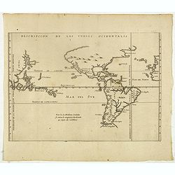
Descripcion de las Yndias Ocidentalis.
Rare early general map of America, the Pacific Ocean and the Eastern part of Asia. Showing "Meridiano de la demarcacion porla parte oscidental" - and "... ...
Place & Date: Amsterdam, Michel Colin, 1622

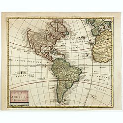
Americae Nova Tabula.
The delineation of the coast and the nomenclature on both the Pacific and Atlantic coasts are basically Spanish in origin and follow the maps of Ortelius and Wytfliet. To...
Place & Date: Amsterdam, 1645
![[Printed on silk] Nova Totius Americae Sive Novi Orbis Tabula, Auct. Hugo Allardt.](/uploads/cache/48420-250x250.jpg)
[Printed on silk] Nova Totius Americae Sive Novi Orbis Tabula, Auct. Hugo Allardt.
Hugo Allard’s ca. 1661 map of the Americas, showing California as an island printed on silk. This separately issued map printed on paper is quite rare on the market. T...
Place & Date: Amsterdam, 1661
Nieuwe kaart van America.
An attractive map of both the Americas, by one of the leading mapmakers in 18th century Amsterdam. Isaak Tirion (d. 1769) was a Amsterdam publisher. His "Nieuwe en b...
Place & Date: Amsterdam, 1765