Browse Listings
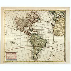
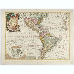
Nieuwe kaart van America.
An attractive map of both the Americas, by one of the leading mapmakers in 18th century Amsterdam. Isaak Tirion (d. 1769) was a Amsterdam publisher. His "Nieuwe en b...
Date: Amsterdam, 1765
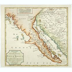
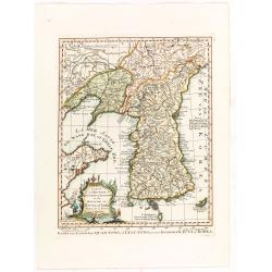
Kaart van het Westelyk Gedeelte van Nieuw Mexico en van California. . . MDCCLXV ..
A detailed map of the Baja California and Sonora, bounded on the north by the Colorado and Gila Rivers and approximately Mozatlan in the south, thus including parts of mo...
Date: Amsterdam, 1765

Carta Topografica dell' Isola Del Maritaggio di Monsieur le Boble per la prima volta. Tradotta dal francese in italiano.
Second Italian printing of Eustache Le Noble’s "Carte de l’isle de marriage." The book’s text offers instructions on how to reach this matrimonial island ...
Date: Cosmopoli, 1766

America settentrionale. . .
Rare map of North America drawn directly from the work of Nicholas De Fer and N. Sanson's famous map of 1650. The map is engraved by Antonius Donzel Gallus.With open Grea...
Date: Napels, 1766
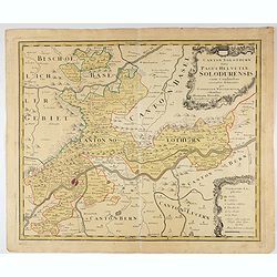
Canton Solothurn sive pagus Helvetiae Solodurensis cum confinibus recenter delineatus per Gabrielem Walserum.
A nice map of Swiss canton centered on Solothurn. Engraved by Tobias C. Lotter.
Date: Augsbourg, 1766
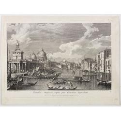
Canalis majoris caput qua Venetias ingreditur.
Bucentaurus et Nundinae Venetae in die Ascensionis". The Doge leaving for the Lido on the Bucintoro on Ascension Day.From the series of 12 views entitled Feste Ducal...
Date: Venice, c. 1766
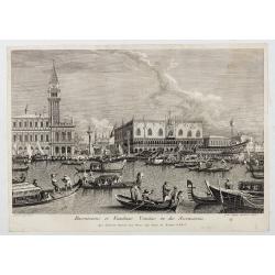
Canalis majoris caput qua Venetias ingreditur.
Canalis majoris caput qua Venetias ingreditur". A view of the Grand Canal with Santa Maria della Salute to the left after Canaletto.From the series of 12 views entit...
Date: Venice, c. 1766

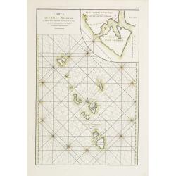
Carte Réduite De La Partie Septentrionale De L'' Isle De Terre Neuve..
A well engraved and highly detailed chart, corrected to 1767. Elaborate hand-colored cartouche, rhumb lines.Shows northern part of Newfoundland and southern coast of Labr...
Date: Paris, 1767
![The Coast of New Found Land From Salmon Cove to Cape Bonavista. . . [together with] The Coast of New Found Land from Cape-Raze to Cape St-Francis.](/uploads/cache/40658-250x250.jpg)
The Coast of New Found Land From Salmon Cove to Cape Bonavista. . . [together with] The Coast of New Found Land from Cape-Raze to Cape St-Francis.
Two charts showing the coast of New Found Land from Salmon Cove to Cape Bonavista and from Cape-Raze to Cape St-Francis. With inset chart of Trinity HarborGrierson publis...
Date: Dublin, 1767

The Harbour of Casco Bay and Islands Adjacent Bt Capt. Cyprian Southicke.
The earliest printed chart of Casco Bay, an inlet of the Gulf of Maine on the southern coast of Maine, New England. First issued in 1720 by Mount and Page, it remained in...
Date: Dublin, 1767

s'Lands en Oost-Indische Lynbanen.
A decorative print of the Lynbanen a place were V.O.C. ship riggings and ropes were produced and kept.
Date: Amsterdam, 1760-1767

t'Oost-Indisch-Huys.
A decorative print of the East Indian House, the headquarters of the V.O.C., a place for meeting, trading and storage of spices and ship equipment. The maps and charts we...
Date: Amsterdam, 1760-1767

s'Lands en Oost-Indische Lynbanen. & t'Oost-Indisch-Huys.
A decorative print of the Lynbanen a place were V.O.C. ship riggings and ropes were produced and kept.
Date: Amsterdam, 1760-1767

Vermakelykheden van Brabant, en deszelfs onderhoorige Landen... (2 volumes)
Topographical and iconographical work on Brabant illustrated with 1 engr. title-vignette and 190 engraved views, plans & armorial plates by J. Harrewijn, G. Bouttats ...
Date: Amsterdam, P.J. Entrop, 1768

Nouveau théâtre de la guerre entre les Russes les turcs et les polonois confédérés.
A very rare separately published map of Crime region. With a large title cartouche lower left "Nouveau theâtre de la guerre entre les russes, les turcs et les polon...
Date: Paris, 1769

Nieuwe Kaart van de Grootbrittannische Volkplantingen in Noord America waar in Tevens de Fransche Bezittingen en de Landen tuschen die Beide Volken. . .
A map of the east-coast of America from New Foundland till Florida, divided in French and British properties. Reduced size Dutch edition of Mitchell's map of North Americ...
Date: Amsterdam, 1769

Nieuwe kaart van Kanada . . .
Nice map of the Bay of Hudson, In Labrador, a small inset of Nova Scotia. The map is dated 1769. All text is in Dutch. The map shows the region shortly after the conclusi...
Date: Amsterdam, 1769

Plan der Stadt Quebec Haupstadt in Neu Franckreich oder Canada.
Town-plan of Quebec, with an inset view of the town in the lower right corner. In the upper right a recapitulation of the main military actions prior to the surrender of ...
Date: Nurnberg, 1770
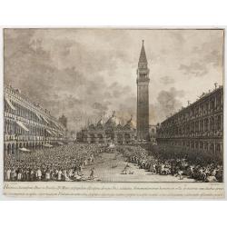
Habita a Serenissimo Duce in Basilica D.Marci ad populum allocutione…
Habita a Serenissimo Duce in Basilica D.Marci ad populum allocutione, ab eoque Dux salutatus, Armamentariorum humeris in sella gestatoria cum duobus proxime consanguineis...
Date: Venice, c. 1766-1770

Réjouissances du Peuple près de la Pyramide d'Illumination, élévée sur l'Esplanade de la Porte de Mars et Distribution de Vivres, fontaines de Vin , sous les Ordres de Mrs. Du Conseil de la Ville, à Reims le 27 Aoust 1765.
Engraved by Varin after Moreau Jr. The print shows a lightning spectacle held in Reims on 27 August 1765.
Date: Paris, 1771

(upper sheets only) Asia According to the Sieur D'Anville Divided into its Empires, Kingdoms and States Showing the European Settlements in the East Indies and all the New Discoveries . . . 1772
Highly detailed map of Russia, including Turkey, China and Korea. Based on the cartography of the famous French cartographer Jean Baptiste Bourguignon d' Anville. Only th...
Date: London, 1772
Carte des parties nord et ouest de L' Amerique. . .
An interesting map of North America, based upon an earlier map by Thomas Engel. His map of North America was issued in his 'Memoires Observations Geographique' in 1765, a...
Date: Paris, 1772
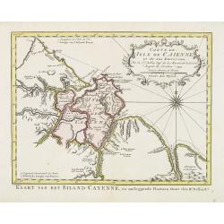
Carte de L'Isle de Caiene et de ses environs.
Uncommon edition of this accurate map of Cayenne. In lower right engraved "31."From Atlas Portatif pour servir a l'intelligence de l'Histoire Philosophique et P...
Date: Amsterdam, 1773
![Coffre Sculpté des Habitants de la nouvelle Zélande. [Tome III Pl. 13.]](/uploads/cache/26092-250x250.jpg)
Coffre Sculpté des Habitants de la nouvelle Zélande. [Tome III Pl. 13.]
A carved chest of New Zealand, as a specimen of the carving of the country. Engraving drawn after John Frederick Miller (1759-1796). John Frederick Miller was an English ...
Date: Paris, 1773
![Vue de la Rivière d'Endeavour sur la Côte de la Nouvelle Hollande ou le Vaisseau fut mis à la bande. [Tome IV Pl. 1ère.]](/uploads/cache/26093-250x250.jpg)
Vue de la Rivière d'Endeavour sur la Côte de la Nouvelle Hollande ou le Vaisseau fut mis à la bande. [Tome IV Pl. 1ère.]
The first known landscape drawing of the east coast of Australia. A View of the Endeavour River, on the coast of New Holland, where the ship was laid on shore, in order t...
Date: Paris, 1773
![Hausse-col militaire des insulaires de la Mer du Sud. [Tome II Pl. 12.]](/uploads/cache/26095-250x250.jpg)
Hausse-col militaire des insulaires de la Mer du Sud. [Tome II Pl. 12.]
Maori warrior rise-collar. From the French edition of James Cook's first voyage entitled Relation des voyages entrepris par ordre de sa Majesté Britannique actuellement ...
Date: Paris, 1773
![Instruments des insulaires de la Mer du Sud. [Tome II Pl. 15.]](/uploads/cache/26097-250x250.jpg)
Instruments des insulaires de la Mer du Sud. [Tome II Pl. 15.]
Divers tools. From the French edition of James Cook's first voyage entitled Relation des voyages entrepris par ordre de sa Majesté Britannique actuellement régnante pou...
Date: Paris, 1773
![Emouchoir des Otahitiens avec ses manches. [Tome II Pl. 13.]](/uploads/cache/26098-250x250.jpg)
Emouchoir des Otahitiens avec ses manches. [Tome II Pl. 13.]
The print depicts three ceremonial fly-whisks from Tahiti. Each object features ornate carved handles with anthropomorphic figures and long flowing fibers, accompanied by...
Date: Paris, 1773
![Vue de l'Isle d'Otahiti et de plusieurs Pirogues. [Tome II Pl. 11.]](/uploads/cache/26102-250x250.jpg)
Vue de l'Isle d'Otahiti et de plusieurs Pirogues. [Tome II Pl. 11.]
View of the Island of Tahiti and dugouts. From the French edition of James Cook's first voyage entitled Relation des voyages entrepris par ordre de sa Majesté Britanniqu...
Date: Paris, 1773
![Vue de l'Isle d'Ulietéa avec une double Pirogue et un hangar où les Insulaires retirent leurs bâtiments de mer. [Tome III Pl. 5.]](/uploads/cache/26106-250x250.jpg)
Vue de l'Isle d'Ulietéa avec une double Pirogue et un hangar où les Insulaires retirent leurs bâtiments de mer. [Tome III Pl. 5.]
A view on the Island of Ulietea, French Polynesia, of a dugout boat house and a beautifully engraved pirogue at sea. From the French edition of James Cook's first voyage ...
Date: Paris, 1773
![Vue de l'Isle d'Huaheine avec La Maison de Dieu, et un petit Autel couvert d'offrandes. [Tome III Pl. 4.]](/uploads/cache/26108-250x250.jpg)
Vue de l'Isle d'Huaheine avec La Maison de Dieu, et un petit Autel couvert d'offrandes. [Tome III Pl. 4.]
A view of the Island of Huaheine, Tahiti, a beautiful tropical Owharra tree in the foreground and a depiction of the House of God with its offertory. From the French edit...
Date: Paris, 1773
![Vue d'un Rocher troué de la Nouvelle Zélande. [Tome III Pl. 8.]](/uploads/cache/26112-250x250.jpg)
Vue d'un Rocher troué de la Nouvelle Zélande. [Tome III Pl. 8.]
A view of a New Zealand landscape and seascape through a hollow rock. Engraved by Demouchy. From the French edition of James Cook's first voyage entitled Relation des voy...
Date: Paris, 1773
![Manière dont on expose les morts à Otahiti. [Tome II Pl. 16.]](/uploads/cache/26113-250x250.jpg)
Manière dont on expose les morts à Otahiti. [Tome II Pl. 16.]
A view of a Tahitian funeral home in a beautiful landscape. Engraved by Demouchy. From the French edition of James Cook's first voyage entitled Relation des voyages entre...
Date: Paris, 1773

Carte de la Coste d'Arabie.
Uncommon issue of this very nice map of the Arabian peninsula. Depicted is Saudi Arabia, Red Sea and the Persian Gulf.With French text in title cartouche and an additiona...
Date: Amsterdam, 1773
Carte de la province de Quan-tong, ou Lyau-tong et du Royaume de Kau-li ou Corée. . . / Kaart van t' Landschap Quan-Tong . . .
Uncommon issue of this fine map of Korea. The map is of interest for the use of East Sea, the sea between Korea and Japan, here called "Mer de Corée.Decorative titl...
Date: Paris, 1749-1773

Terrae Yemen Maxima Pars, seu Imperii Imami, Principatus Kaukeban nec non ditionum Haschid u Bekil, Nehhm, Chaulan, Abu Arisch et Aden Tabula ...
South-west Arabia, with the Saudi Arabian city of Jizan south to Aden. With a fine title, cartouche. Based on a map by Carsten Niebuhr. With the name Sinus Arabicus Mare ...
Date: Augsbourg, 1774
![Village fortifié bâti sur un Rocher troué de la Nouvelle Zélande. [Tome III Pl. 10.]](/uploads/cache/26110-250x250.jpg)
Village fortifié bâti sur un Rocher troué de la Nouvelle Zélande. [Tome III Pl. 10.]
A view of a village fortified on a hollow rock in New Zealand. Engraved by François Godefroi. From the French edition of James Cook's first voyage entitled Relation des ...
Date: Paris, 1774
![Cession de l'Isle d'Ohahiti au Capitaine Wallis par la Reine Obéréa. [Tome II Pl. 2.]](/uploads/cache/26111-250x250.jpg)
Cession de l'Isle d'Ohahiti au Capitaine Wallis par la Reine Obéréa. [Tome II Pl. 2.]
Queen Oberea's transfer ceremony to Captain Wallis on Tahiti.Engraved by François Godefroi. From the French edition of James Cook's first voyage entitled Relation des vo...
Date: Paris, 1774
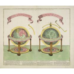
GLOBUS TERRESTRIS ad sphaeram obliquam delineatus. and the GLOBUS COELESTIS cum Astrodictico artificiali iunctus.
A very handsome, large copper engraving of a pair of globes. Ribbon style titles and German text panel at bottom.
Date: Augsburg, 1774
Vue de la Rade et de la Ville de Paramaribo.
A very decorative panoramic view of the town with a large Dutch vessel in the foreground. Engraved by Noach van der Meer Junior. Included in a Dutch edition of "Hist...
Date: Amsterdam, 1774
Carte D'Amerique divisée en ses principaux Pays Dressée sur les Mémoires les plus recents, et sur differents Voyages et assujettie aux Observations Astronomiques de Mrs. de l'Academie Royal des Sciences Par Mr. l'Abbe Clouet . . . 1774.
The rare 1774 edition of this fine map of the western hemisphere published by Clouet in Rouen. A later edition with the date 1787 also exists. With inset map "Carte ...
Date: Paris, 1774
![[HAWAII] - Plan de la baye de Karakakooa.](/uploads/cache/48173-250x250.jpg)
[HAWAII] - Plan de la baye de Karakakooa.
Beautiful map showing the islands forming the Hawaiian archipelago, drawn up during Cook's third voyage: Oneeheow or Ni'ihau, Atooi or Kauai, Woahoo or O'ahu, Morotoi or ...
Date: Paris, 1774
![[Haida Gwaii,] Baye Swallow . . . / Havre Byron /Côté septentrional de la plus grande des Isles de la Reine Charlotte. . . .](/uploads/cache/25888-250x250.jpg)
[Haida Gwaii,] Baye Swallow . . . / Havre Byron /Côté septentrional de la plus grande des Isles de la Reine Charlotte. . . .
Map of Swallow's Bay and a coastline profile of the Queen Charlotte Islands and Captain Byron's Heaven.Queen Charlotte Islands, with their modern name Haida Gwaii, is an ...
Date: Paris, 1774

A chart of the China Sea inscribed to Monsr. D'APRES de MANNEVILLETTE .. To A.Dalrymple.
This most important milestone chart is based upon the surveys made from navigational surveys by Alexander Dalrymple (1737-1808]. He was the first hydrographer of the Brit...
Date: Paris, ca 1775
Carte des Isles Nicobar... (with) Plan particulier du Port compris entre les Isles Nacaveri, Souri, et Tricutte.
French chart of Isles of Nicobar in Gulf of Bengal near Birmanie and Sumatra. Prepared by Jacques-François L'Abbé Dicquemare (1733-1789). Latitude and longitude scales,...
Date: Paris, Brest, chez Demonville, 1775
![Planisphere celeste Septentrional. . . [together with] Planisphere celeste meridional. . .](/uploads/cache/35291-250x250.jpg)
Planisphere celeste Septentrional. . . [together with] Planisphere celeste meridional. . .
Beautiful set of celestial charts of the northern and southern skies by the well-known French astronomer, Philippe de La Hire. Surrounded by panels of astronomical notes ...
Date: Paris, ca.1775
![Schat-Kamer ofte konst der stuurlieden, behelzende een duidelyke onderwyzinge in de navigatie. . . [bound with] Tafelen bevattende De Sinussum, tangenten en Secanten. . . [bound with] Geographische Tadfel...](/uploads/cache/33112-250x250.jpg)
Schat-Kamer ofte konst der stuurlieden, behelzende een duidelyke onderwyzinge in de navigatie. . . [bound with] Tafelen bevattende De Sinussum, tangenten en Secanten. . . [bound with] Geographische Tadfel...
Schat-Kamer ofte konst der stuurlieden, behelzende een duidelyke onderwyzinge in de navigatie. . . [bound with] Tafelen bevattende De Sinussum, tangenten en Secanten. . ....
Date: Amsterdam, J. v. Keulen en Zoonen, 1777

A Map of the most Inhabited part of New England containing the Provinces of Massachusetts Bay and New Hampshire, with the Colonies of Connecticut and Rhode Island.
A copper engraving in four sheets, published in Georges Louis Le Rouge, in his "Atlas Ameriqua in Septentrional Contenant les details des differentes provinces, de c...
Date: Paris, 1777

A plan of the City and Environs of Philadelphia. . .
The Lotter edition of Scull & Heap's seminal Philadelphia map, which map was first issued in 1752.Holmes' grid plan for the city is shown, situated between the rivers...
Date: Augsburg, 1777

Carte nouvelle de l'Amérique angloise contenant tout ce que les Anglois possèdent. . . avec la Floride / gravée. . . par Maththias Albert Lotter. . .
As mentioned in the title piece, the map includes the area at that time in the possession of the English, i.e. Canada, New Large, beautiful and detailed map of the Easter...
Date: Augsburg, 1777
![[ Text / title page Charts of the coasts and harbours of New England . . .]](/uploads/cache/44832-250x250.jpg)
[ Text / title page Charts of the coasts and harbours of New England . . .]
Letterpress text page, taken from the "Atlantic Neptune".The Atlantic Neptune is universally recognised as one of the most magnificent atlases ever made.Example...
Date: London, 1777
![[Lower half] Amerique Septentrionale avec les Routes, Distances en miles, Limites et Etablissements François et Anglois Par le Docteur Mitchel Traduit de 'Anglois..](/uploads/cache/49378-250x250.jpg)
[Lower half] Amerique Septentrionale avec les Routes, Distances en miles, Limites et Etablissements François et Anglois Par le Docteur Mitchel Traduit de 'Anglois..
This is the important 1777 Georges Le Rouge French edition of the seminal John Mitchell map of the eastern part of North America. The Mitchell map is considered the singl...
Date: Paris, 1777

Ilse Paese de' Selvaggi.. Lago Superiore. (Florida and the Bahamas)
Antonio Zatta published an Italian version of the John Mitchell map in twelve sheet. This sheet depicts Lake Superior in the Bellin version, as it appeared on the Mitchel...
Date: Venice, 1778

Etats du Grand-Seigneur en Asie, empire de Perse, pays des Usbecs, Arabie et Egypte.
Detailed map of the region bounded by the Black Sea, Georgia, the Caspian, Uzbekistan, The Indian Ocean, Saudi Arabia (here called \"Arabie Heureuse\"), Egypt a...
Date: Venise, 1778

Carte Réduite Des Côtes Orientales De L' Amérique Septentrionale Contenant Partie du Nouveau Jersey.. Virginie.. Georgie..
Uncommon chart that extends from Delaware Bay and Philadelphia south through much of Georgia to Island Amelia and St. Johns River. Fleur-de-lis and rhumb lines fill the s...
Date: Paris, 1778

Africa juxta navigationes et observat recentissimas. . .
Miniature map of Africa, a reduction of the Seutter folio map based on Homann''s cartography of 1715. Very detailed - much of it fictitious. The Nile is shown not only or...
Date: Augsburg, J.M.Will, 1778

A new & accurate map of Asia, Drawn from the most approved modern maps & charts / by Thos. Bowen.
The map is of interest for the use of Sea of Korea, the sea between Korea and Japan.Detailed map of Asia from Saudi Arabia, Persia, Russia, India, China, Japan to Southea...
Date: London, J.Cooke, 1777-1778
Selling price: ????
Please login to see price!
Sold in 2023

Mappa Geographica provinciae Nova Ebboraci ab Anglis NEW-YORK dictae. . .
During the Revolution, this map afforded British commanders an excellent overview of areas that would be crucial in the early years of the war, particularly the Hudson Va...
Date: Nuremberg, 1778

Mappa geographica Provinciæ Nova Eboraci ab Anglis New-York . . .
Lower part of the two sheets map of Homann Heirs' edition of Sauthier's celebrated map of New York and New Jersey, made during the Revolutionary War. Appears in Homann's ...
Date: Nuremburg, 1778

Chirurgie, plate XII
Showing medical chair and physician at work from the medical section of Diderot's Encyclopaedia. Engraved by Bernard after a design of Goussier. Very important work as it...
Date: Paris 1779

Carte des parties Nord et est de l'Asie..
Five maps on one sheet show the Northern Russian territories in Europe and Asia, including the western coastline from Siberia, Japan, and Korea with the island of "Q...
Date: Paris, 1779
![[Title page] Atlante Novissimo, Tomo I . . .](/uploads/cache/43898-250x250.jpg)
[Title page] Atlante Novissimo, Tomo I . . .
Decorative Venitian frontispiece from Antonio Zatta's "Atlante Novissimo tomo I".
Date: Venice, 1779

Gezicht van het Admiraliteits-Magazyn en Scheeps Timmerwerf.
Formerly the V.O.C. warehouse and arsenal for the Admiralty of Amsterdam, now-a-days the Scheepvaartmuseum (Maritime Museum). Taken from the "Atlas of Amsterdam"...
Date: Amsterdam, 1780

A Perspective View of the Admiralty Office, Dock-Yard, Storehouses &c. at Amsterdam.
Decorative engraving giving good detail of the intense activity in the Amsterdam dockyards.Engraved for BANKES's New System of Geography
Date: Amsterdam, 1780

Carte d'une Partie des Cotes de la Floride et de la Louisiane, Contenant le Cours du Mississipi...
A well engraved and highly detailed chart of part of the Gulf Coast, dated 1778 that was issued in Neptune americo-septentrionale. The chart covers the area between St. J...
Date: Paris, 1778-1780

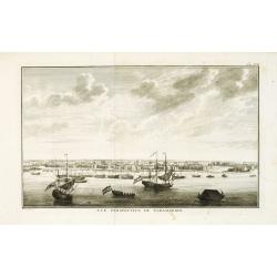
Vue du Magazin de la Compagnie des Indes Orientales. . .
So-called optical print of the formerly the V.O.C. warehouse and arsenal for the Admiralty of Amsterdam, now-a-days the Scheepvaartmuseum (Maritime Museum).In the eightee...
Date: France, 1780

Madrid.
Extremely rare town-view of Madrid. Engraved by Francesco Ambrosi.With a second title in lower part "Madrid Ciudad Capital Del Reyno D'Espana y real corte de los rey...
Date: Bassano del Grappa, c.1780

Gezicht van het Oost-Indisch-Huys, op de binnen plaats te zien, tot Amsterdam.
Taken from the "Atlas of Amsterdam". Showing the inner square of the East Indian House of the V.O.C. in Amsterdam.A place for meeting, trading and storage of sp...
Date: Amsterdam, 1780

La Pologne Dressée sur ce qu'en ot donné Starovolsk, Beauplan, Hartnoch. . .
Large map of Poland, Lithuania, Belarus and part of Ukraine. The map is filled with detail and decorated with a title cartouche flanked by mythological figures.According ...
Date: Paris, 1773 - 1780

Vue perspective de l'interieur de la Salle du spectacle de Veronne en Italie.
Showing the Opera of Verona. Optical print published Mondhare, who was a well-known publisher of optical prints, established in rue St. Jacques in Paris. In the eighteent...
Date: Paris, ca. 1780
![Une Kirguisiene par devant. [together with] Une Kirguisienne par derriere.](/uploads/cache/32991-250x250.jpg)
Une Kirguisiene par devant. [together with] Une Kirguisienne par derriere.
Uncommon copper-engraved costume plate showing two natives of Kyrgyzstan, a Central Asian country along the Silk Road, the ancient trade route between China and the Medit...
Date: St. Petersbourg, C.G. Müller, 1776-1780

Le globe terrestre representé en deux plans-hemispheres, Dressé sur la Projection de Mr. De la Hyre...
“This splendid GlobeTerrestre originally published by J.B. Nolin is one of the finest large-scale world maps to be produced and is a fitting bridge between the geograph...
Date: Paris, c. 1780

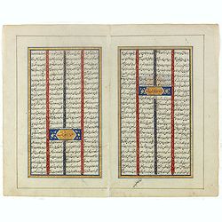
Double page manuscript page with Islamic prayers with beautiful headings throughout.
Fine double page brilliantly illuminated gilt leaves written by the scribe Abu Bakr Jami in Isfahan. The Arabic text contains Islamic prayers with beautiful headings thro...
Date: Isfahan, ca. 1780
Double page manuscript page from a Shahnameh, The Book of Kings, written by Ferdowsi.
Fine double page brilliantly illuminated gilt leaves written by the scribe Abu Bakr Jami in Isfahan. The Arabic text contains Islamic prayers with beautiful headings thro...
Date: Isfahan, ca. 1780
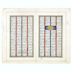
Double page manuscript page from a Shahnameh, The Book of Kings, written by Ferdowsi.
Fine double page brilliantly illuminated gilt leaves written by the scribe Abu Bakr Jami in Isfahan. The Arabic text contains Islamic prayers with beautiful headings thro...
Date: Isfahan, ca. 1780
![Ch'onha chido. [Atlas of all under Heaven]](/uploads/cache/44640-250x250.jpg)
Ch'onha chido. [Atlas of all under Heaven]
A late 18th-century Ch'onha chido atlas with 10 woodblock maps showing the World, China, and the 8 province maps of Korea (Hamgyeong, Gangwon, Jeolla, Gyeongsang, Pyeonga...
Date: Korea, ca. 1780
![[No title.] Sixteen small engravings.](/uploads/cache/46799-250x250.jpg)
[No title.] Sixteen small engravings.
A nice set of sixteen French professions, or trades, or stage characters. The print is faint on some titles. Some of the characters are a soldier, a doctor, a nun, a lawy...
Date: Paris, ca. 1780
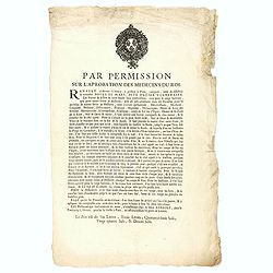
Par permission sur l'aprobation des médecins du roi...la véritable Boule de Mars...
Printed broadsheet promoting the "Boule de Mars" (March Ball) produced and sold by Renault in Nancy and Paris. Ornated with the royal coat of arms of France. Pr...
Date: Paris, ca.. 1780

Connecticut and Parts adjacent at Amsterdam. .
A nice example of this early map of the state of Connecticut with part of Rhode Island to the east, Long Island to the south, and New York to the east. Rivers, roads, t...
Date: Amsterdam, 1780
![[Lot of 4 charts] Plan de la Baie et du Port de Camraigne / Plan de la Baie de Niatrang et du Golfe de Binkang / Plan de la Cote de Cochinchine. . . / Plan des Ports de Xuandai, Vung-Lam. . .](/uploads/cache/44795A-250x250.jpg)
[Lot of 4 charts] Plan de la Baie et du Port de Camraigne / Plan de la Baie de Niatrang et du Golfe de Binkang / Plan de la Cote de Cochinchine. . . / Plan des Ports de Xuandai, Vung-Lam. . .
[A set of four French sea charts numbered consecutively]. A set of 4 basic coastal sea charts of parts of southern French Indochina (Vietnam).Chart 295 centers on the reg...
Date: Paris ca 1780