Wish List
With WishList / Virtual Collection, you can save and collect your favorite items in one place, it is free and you can delete an item from your list at any time.
Save any of the 30.000+ maps, prints or Medieval manuscripts from our BuyNow Catalog or Catalog Archive.
Unless logged in, an item is only saved for that session. If you want to save the items permanently, please log in first.
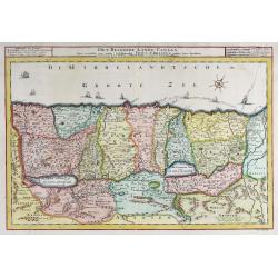
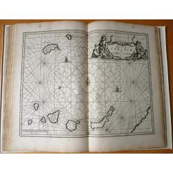
Het Beloofde Landt Canaan.
Fine map of Israel with north oriented to right. Finely engraved and very detailed map of the Holy Land embellished with sailing ships and compass rose. Dutch text on ve...
Place & Date: Amsterdam, 1720
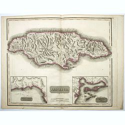
Jamaica.
A nice example of the Jamaica map from Thomson's 'New general Atlas'. The island is shown at the top, while beneath it are two insets; one of 'The Harbour of Bluefields',...
Place & Date: Edinburgh, 1814
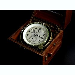
A two-day marine Chronometer, No. 8185.
The 4inch frosted dial signed Chronometerwerke, Wempe, Hamburg, and numbered 8185, upright black Arabic numerals, subsidiary seconds and up-and-down dials, blued steel ha...
Place & Date: Hamburg, 1968
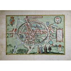
Cantuarbury (Canterbury)
A decorative late 16th century bird's-eye view of the historic city of Canterbury. The plan recognises important sites and displays four coats-of-arms. In the foreground ...
Place & Date: Cologne ca. 1588
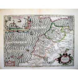
Fessae et Marocchi Regna.
A large, richly embellished map of the north west part of Africa. It shows mostly Morocco, but also a part of the Iberian peninsula, the area south of Morocco, as well as...
Place & Date: Amsterdam, 1610 - 1630
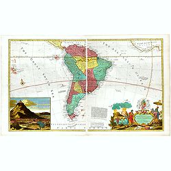
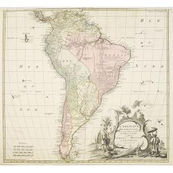
...this map of South America...
Map of South America including part of Central America. Cartographic elements include lines of latitude and longitude, compass rose, indication of wind directions, locati...
Place & Date: London 1725
Selling price: $2100
Sold in 2021
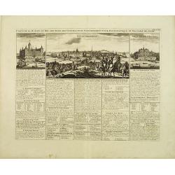
Carte de la on du Roy, des etats, des conseils et du government civil, ecclesiastique, et militaire de Suede.
This impressive engraving is a wonderful example of Chatelain's elegant plates.Fine panoramic view of Stockholm in the upper top. Exhaustive information about each scene ...
Place & Date: Amsterdam, ca. 1720
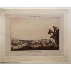
Lisbon & Aqueduct of Alcantara.
A scarce aquatint view of Lisbon from the city's aqueduct. A fine, strong copperplate imprint showing some key buildings with sailing ships in the background.
Place & Date: London, 1809
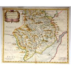
The County of MONMOUTH By Robt Morden.
An attractive map of Monmouthshire by Robert Morden which appeared in Camden's Britannia (London: Swale, Awnshaw & Churchill, 1695). Bishop Gibson described the maps ...
Place & Date: London, 1695
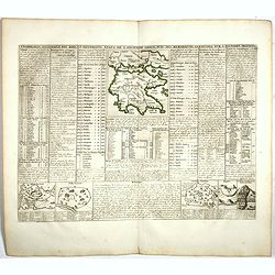
Cronologie Historique des Rois & des différens Etats de l'Ancienne Grèce . . .
Showing in top a map of ancient Greece (130 x 115mm.) with vignette views of the City States of Athens, Thebes and Corinth. The surrounding text details the history of Gr...
Place & Date: Amsterdam, 1720
Selling price: $50
Sold in 2022

The Two Grandmothers.
A group watching a girl dancing, a girl in the centre dancing with cymbals, to the tune of tambourine played by another on the left, flanked by two old women glaring at e...
Place & Date: London, 1854
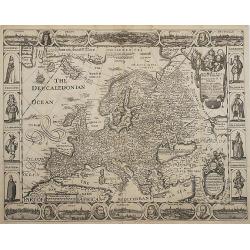
A New Plaine and Exact Map of Europe...
A very rare map with portraits and views on all sides. "Robert Walton was one of a handful of map publishers in London during the 1650s. In 1656 he produced a world ...
Place & Date: London, 1660
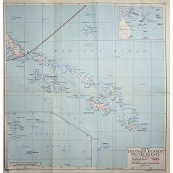
British Solomon Islands Protectorate
A detailed map of the Solomon Islands in the Pacific Ocean, published by the Directorate of Colonial Surveys, and printed by the War Office in 1948.
Place & Date: London, 1948
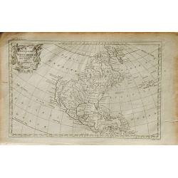
An Accurate Map of North America Drawn from the Sieur Robert, with Improvements.
A scarce map of North America by George Rollos, after Robert de Vaugondy. The map illustrates the continent after the conclusion of the French and Indian War. The colonie...
Place & Date: London, 1762

Mr. Punch on the Links.
Golfing cartoon taken from the famed English humor magazine Mr. Punch on the Links. Size of the frame : 20,5x25,5cm.HUSBAND. " 'Ere, let's move on, it's getting late...
Place & Date: London, Methuen, 1929
![[No title] A map of the Arabian Peninsula.](/uploads/cache/00691-250x250.jpg)
[No title] A map of the Arabian Peninsula.
Large scale map of southern half of Arabian Peninsula, including Bahrain, Oman, etc. To the left the River Nile. With inset maps of a source of the River Nile and Route d...
Place & Date: Paris, c.1780

Le corps de Thee, Chef de O-taiti, ...
From the French edition of James Cook's third voyage entitled Troisième Voyage de Cook, ou Voyage à l'Océan Pacifique, ordonné par le Roi d'Angleterre, pour faire des...
Place & Date: Paris, 1785
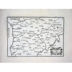
CARTE DU VALOIS
Nice map from Tassin's desirable and scarce Atlas "Cartes generales de toutes les Provinces de France et d'Espaigne..." published by Berey in 1648. Very detaile...
Place & Date: Paris, 1648
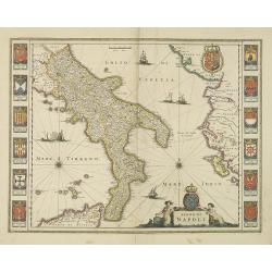
Regno di Napoli.
To the left and right 12 coats of arms of different regions.As Willem Blaeu died in 1638 most of his maps are actually published by his son Joan. This map was actually pu...
Place & Date: Amsterdam, 1638
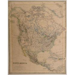
North America by Keith Johnston, F.R.S.E. Engraved & printed by W. & A.K. Johnston
Large engraved map. Highly detailed. Relief shown by hachures and spot heights. "Keith Johnston's general atlas 41."Published by William Blackwood & Sons Ed...
Place & Date: Edinburgh, 1861
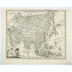
A new & accurate map of Asia drawn from actual surveys. . .
An excellent early engraving of Asia. There is a curious shape for Japan, with a large island north called Yedso and a coastline marked De Gamma's Land. The map renders t...
Place & Date: London, 1747
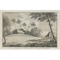
A View of Afi-Too-Ca, a Burying Place, in the Island of Amsterdam.
Engraved illustration published in : "A voyage towards the South Pole, and round the World." by James Cook.
Place & Date: London, 1777
Platte Grond van de Kaap van St. Francois.
A detailed and attractive inset plan of Cap Francois, and in the larger map Cap Francois and her surrounds, located on the north coast of Hayti. It was an important city ...
Place & Date: Amsterdam, ca 1772
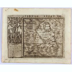
Tabula Asiae XII. (Sri Lanka)
Gastaldi's map showing Sri Lanka, based upon Ptolemy's twelfth map of Asia depicting Taprobana. With a decorative scene with elephant and descriptive text next to the map...
Place & Date: Venice, 1548
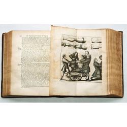
A general system of surgery in three parts.
The segments are I. Of Wounds, Fractures, Luxations, Tumours, and Ulcers, of all Kinds. II. Of the several Operations performed on all parts of the Body. III. Ofthe sever...
Place & Date: London 1753
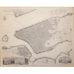
New York. SDUK
A highly detailed mid-19th century plan of the city of Philadelphia by the Society for the Diffusion of Useful Knowledge.It depicts the entire city in remarkable detail, ...
Place & Date: London, 1840
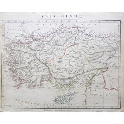
Asia Minor.
A clean example of Aaron Arrowsmith's 1828 map of Asia Minor. A highly detailed map of Asia Minor. The regional boundaries are colored and relief shown by hachures. This ...
Place & Date: London, 1828
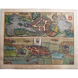
EUTIN & TØNDER, Oitinense oppidulum et arx Episcopi Lubecensis sedes / Delineatio Civitatis Tonderensis.
Two bird's-eye plans on one sheet: Tønder (Denmark) and Eutin (Germany) by Braun & Hogenberg. From: 'Civitates Orbis Terrarum', ... Part 5. Köln, 1596.EUTIN CAPTIO...
Place & Date: Cologne, 1596

Veue de PARIS du Côte du Nord
Very rare and highly detailed copper engraved panoramic view of Paris, France. A numbered 1-31 key along the lower side identifying major buildings and important places w...
Place & Date: 1715
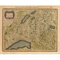
Das Wiflispurgergov.
Nice small map of the region including Geneva and the area north of Lake Geneva, including Bern. Strapwork title cartouche. Latin text on verso.
Place & Date: Amsterdam 1634
![[Lot of 7 maps] Paraguay, Ó Prov. de Rio de la Plata cum regionibus With Arnold Montanus's and Tirion's of the countries bordering the Rio de la Plata. and Isaak Tirion's map of the same area.](/uploads/cache/18260-(2)-250x250.jpg)
[Lot of 7 maps] Paraguay, Ó Prov. de Rio de la Plata cum regionibus With Arnold Montanus's and Tirion's of the countries bordering the Rio de la Plata. and Isaak Tirion's map of the same area.
Willem Blaeu, founder of the famous publishing firm. Originally publishing pilot-guides, he issued his first atlas, 'Atlantis Appendix', in 1630, followed by his "...
Place & Date: 1635
Selling price: $200
Sold in 2022
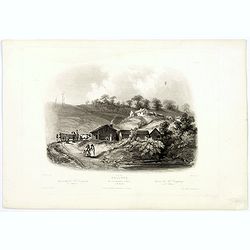
Bellvue. Mr Dougherty's Agency on the Missouri.
An evocative scene of the frontier trading post of Mr Dougherty's Indian Agency, sketched in the May of 1833. An uncolored aquatint engraving depicting an native Indian c...
Place & Date: Pars, Coblenz, London, 1839

Carte des Isles d'Acores.
Uncommon and detailed map of the Azores. With inset maps of Port de St.Cruz and harbor and town of Angra on the island of Terceira. It was at the time an important port a...
Place & Date: Amsterdam, 1730
Selling price: $450
Sold in 2024
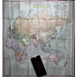
Scarborough's map of the World.
A very large folding double-sided World map, North and South America on one side, the rest of the World on the other. Printed on oiled silk. Shows all sea lanes, ocean cu...
Place & Date: London, 1910
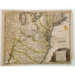
A MAP OF THE BRITISH AMERICAN PLANTATIONS, Extending From Boston.Including All The Back Settlements In The Respective Provinces, As Far As The Mississippi
Covers New York and areas of New England, Pennsylvania, Maryland, Virginia, North and South Carolina, Georgia and other states reaching to the Mississippi River. Iden...
Place & Date: London, 1754
Selling price: $130
Sold in 2023
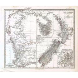
West-Australien - Neu-Seeland.
Adolph Stieler's map of Western Australia and New Zealand.
Place & Date: 1873
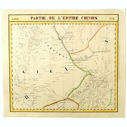
Partie de L'Empire Chinois - No.47.
One of Vandermaelen's 378 conjoined maps on a uniform scale to made up the total globe. This map features the Eastern Mongolia portion of China with Oloa Baytin. Interest...
- $75 / ≈ €67
Place & Date: Brussels, 1825-1827
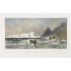
Débarquement sur les iles Powell, le 20 février 1838.
Exquisite contemporary colored lithograph of the Powell islands, situated near the South Orkney Islands, with Dumont D'Urville's officers leaving the island. Drawn by Lou...
- $400 / ≈ €357
Place & Date: Paris, 1848
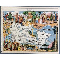
(Decorative pictorial map of Canada by Émile-Joseph Porphyre Pinchon.)
A decorative pictorial map of Canada published in 1948 by children's book illustrator Émile-Joseph Porphyre Pinchon. Émile-Joseph Porphyre Pinchon (Amiens, 17 April 187...
Place & Date: Paris, 1948
L'amerique meridionale dressee sur les memoires le plus recens. . .
Rare and decorative map of South America with good detail and interesting notations concerning the explorations of the interior. With in the lower right corner a title ca...
- $550 / ≈ €491
Place & Date: Amsterdam, 1757

India
This India poster was created circa 1960 by David Klein (1918 -2005) for TWA. The image shows an Indian wall relief with an elephant decorated with precious stones. Eleph...
- $800 / ≈ €715
Place & Date: 1965
![[Title page] Plan général de la ville de Rheims.](/uploads/cache/43845-250x250.jpg)
[Title page] Plan général de la ville de Rheims.
Title page of the town plan "Plan général de la ville de Rheims". This is the title page only, engraved by Jean Lattré. Composed of the coat of arms of Franc...
Place & Date: Paris, Lattré, 1769
Plan de la ville d'Anvers et de son agrandissement général.
Very rare and detailed town plan of Antwerp, published by F.Tessaro and prepared by L.Franck and François Rogmans, dated 1874. In the lower left corner inset of "Pl...
Place & Date: Antwerp, 1874
Carte de la Mer Noire. (1e Feuille). Du Bosphore à Mangalia et du Bosphore au Cap Kerempeh.
Very detailed chart of the Turkish part of the Black Sea including the towns of Constantinople (Istanbul) , Bourgas. Showing soundings in meters, lighthouses are marked w...
Place & Date: Paris, 1860, updated for 1870

Fencing: from: Gerard Thibault, The Academy of the Sword.
A beautiful and very rare engraving from the famous and most comprehensive handbook for the art of fencing: Gerard Thibault (1574-1629): 'Academie de L'Espée de Girard T...
Place & Date: Leiden, 1628
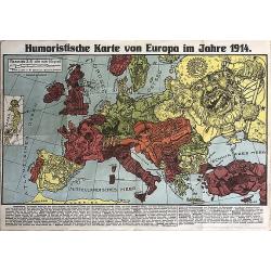
Europe, Japan, Satiriacal Map.
This rare political caricature map of Europe depicts the continent at the outbreak of World War I. The map was created by Karl Lehmann-Dumont in Dresden, and depicts the ...
Place & Date: Dresden, 1914
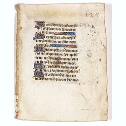
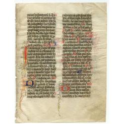
Leaf on vellum from a manuscript Book of Hours.
14 Lines of text in Latin and five 1-line initials in blue on colored grounds with line filler. VERSO : 14 Lines of text in Latin and four 1-line initials in blue on colo...
Place & Date: France, ca.1470
Selling price: $40
Sold in 2023
Ceuta
Magnificent bird's eye- of Ceuta. Etched by Gaspar Bouttats (1640-1695).The Antwerp based publisher Jacques Peeters published ca. 1690 a series of prints related to the H...
Place & Date: Antwerp, c.1690

Femme de nord ets de l'Asie.
Originally hand-colored mezzotint of a woman from Nord West Asia engraved by Félix Mixelle and Lachaussée Jeune after Jacques Grasset de Saint-Sauveur.As an etcher, dra...
Place & Date: Paris,1801-1806
![SINUS RHIZONICUS or GULF of CATARRO [KOTOR,MONTENEGRO], on the COAST of DALMATIA.](/uploads/cache/83605-250x250.jpg)
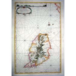
SINUS RHIZONICUS or GULF of CATARRO [KOTOR,MONTENEGRO], on the COAST of DALMATIA.
A nicely colored map shows the Gulf of Kotor, a fjord-like body of water located on the eastern side of the Adriatic Sea. The gulf and the adjacent city have had a long a...
Place & Date: London, 1780
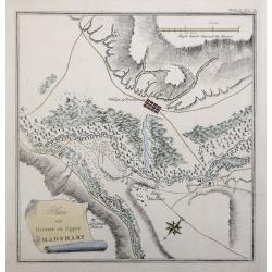
Plan of Greater or Upper Madshary Vol I PL II (Georgia).
A detailed small plan of Madshary in Georgia, from ‘Travels through the southern Provinces of the Russian Empire, in the years 1793 and 1794’.This plan comes from the...
Place & Date: London 1797-1812
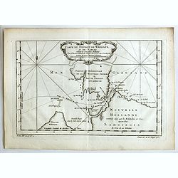
Carte du Détroit de Waeigats ou de Nassau.
An interesting map of the Northern Passage in Russia. Prepared by Jacques Nicolas Bellin after Dutch sources and included in Prévost d' Exile's "Histoire des Voyage...
- $50 / ≈ €45
Place & Date: Paris, 1738-1775
Dapper, Olffert: Naukeurige Beschrijvinge der Afrikaensche Eylanden. (Dapper's description of the Islands of Africa, including Malta.)
Classical work with 9 double page maps, views and plates - including maps of Madagascar, Malta, Canary Islands, Cape Verde Islands and birds eye views of St. Helena and V...
Place & Date: Amsterdam, Jacob van Meurs, 1676
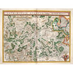
Lorraine: Lotharingia Ducatus vulgo Lorraine.
Attractive folio-size map of Lorraine from Blaeu's atlas of 1634.
Place & Date: Amsterdam, (1631) 1634
![CARTE NOUVELLE D'AMERIQUE. . .[Sea of the West]](/uploads/cache/84936-250x250.jpg)
CARTE NOUVELLE D'AMERIQUE. . .[Sea of the West]
A fine color example of the first state of this scarce map of America by Moithey, Geographer of the King, published in Paris by Philippe de Pretot. It includes a massive ...
Place & Date: Paris ca 1765
Leaf on vellum from a manuscript Breviary
A very charming leaf from a Breviary, written on vellum in France, around 1450, in two columns with much pen work in red and blue; this decoration is further beautified w...
Place & Date: France ca.1450
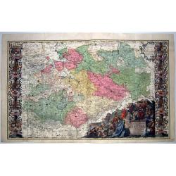
Ducatus Electorat et Principat Ducum Saxoniae... Tab I.
The first and largest in a series of three maps of Saxony by Friedrich Zollman and his brother Philipp Henrich, with an elaborate title cartouche featuring a portrait of ...
Place & Date: Nuremberg, 1731
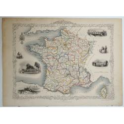
France.
Decorative steel engraved map of France, surrounded by steel engraved vignette illustrations. Further enhanced with a decorative border design.John Tallis and Company pub...
Place & Date: London, ca. 1851
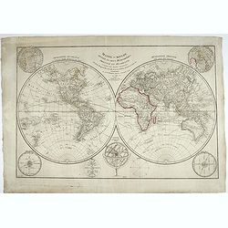
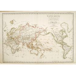
Mappe-monde divisée en deux hémisphères, oriental et occidental, assujetties aux dernières découvertes de Mrs de Bougainville, Surville, Cartret. Wallis, Furneau, Cook, etc, Par J.-B. Poirson...
Fine detailed world map in double hemispheres. Prepared by J.B.Poirson and Herison. According to the title the map is updated with info from travels by de Bougainvill...
Place & Date: Paris, 1798
Selling price: $200
Sold in 2022
![Sphere Terrestre [Globe]](/uploads/cache/90348-250x250.jpg)
Sphere Terrestre [Globe]
This charming miniature globe formed part of a writing-kit which was produced in the early 1900 in Paris. The globe, showing navigation routes and railway lines, is label...
Place & Date: Paris, c. 1914
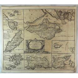
The Smaller Islands in the British Ocean.
A very attractive map of “The Smaller Islands in the British Ocean” including Wight, Alderney, Garnsey, Jersey etc, by Robert Morden, who was commissioned to engrave ...
Place & Date: London, 1695
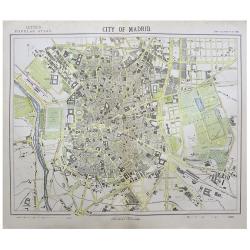
CITY OF MADRID.
A highly detailed late -19th century plan of the city of Madrid. It depicts the entire city in remarkable detail, noting individual streets, important public buildings, r...
Place & Date: London, 1881
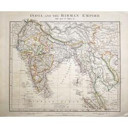
India and the Birman Empire with part of China &c.
A clean example of Aaron Arrowsmith's 1828 map of India. A highly detailed map of Asia. The regional boundaries are colored and relief shown by hachures. This map was pub...
Place & Date: London, 1828
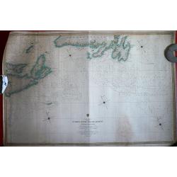
St. Johns Newfoundland to Halifax with the Outer Banks.
Huge and very scarce admiralty chart, showing part of Nova Scotia and Newfoundland. Extremely detailed, showing sea soundings in fathoms but also the many small inlets, b...
Place & Date: London, 1861
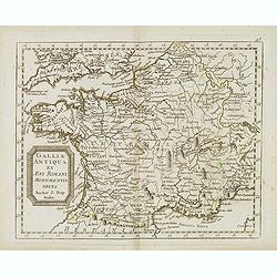
Gallia antiqua ex Aevi Romani monumentis eruta. . .
Historical map of France depicted in Roman times showing ancient divisions, prepared by Nolin and published by L.J. Mondhare for his Atlas Général a l'usage des college...
- $40 / ≈ €36
Place & Date: Paris, 1781
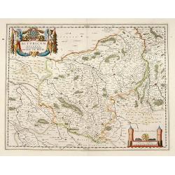
Bituricum Ducatus. Duche de Berri.
A very decorative map with beautiful cartouches of a province of France by one of the most famous map publishers.
Place & Date: Amsterdam, 1645
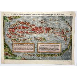
Le cite de Venise tresamble & maritime, avec plusieurs aisles qui sont a l'environ.
A beautifull bird-eye view of Venice with two insets with information about Venice. From "La Cosmographie Universelle, ..." Basel, H. Petri, 1555.
Place & Date: Basle, 1550-1570
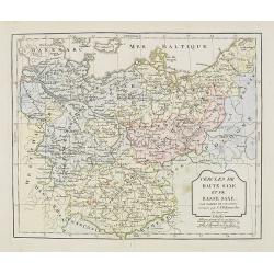
Cercle de Haute Saxe et de Basse Saxe. . .
Map of the duchies of Saxony (upper & lower). By C. F. Delamarche, successor of Robert de Vaugondy, Geographer.
- $50 / ≈ €45
Place & Date: Paris, 1794 - 1806
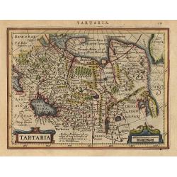
Tartaria.
Decorative small map of the northern region of Asia fully engraved with mountains, forests, and towns. Includes part of China and the island form of Korea. The Anian Fret...
Place & Date: Amsterdam 1634
![Fig. 34. [ Celestial chart depicting the northern constellations]](/uploads/cache/22614-250x250.jpg)
Fig. 34. [ Celestial chart depicting the northern constellations]
A fine celestial chart depicting the northern constellations in allegorical form. Two sailing ships and a harbour on the background.From the German text edition of Descri...
Place & Date: Frankfurt, 1684
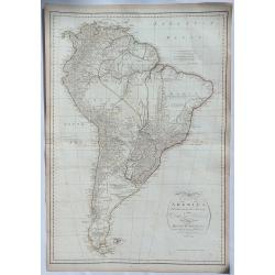
A Map of South America published under the Patronage of the Duke of Orleans. . .
A scarce and highly detailed map of South America, based upon D'Anville's 4 sheet map. Engraved for J Harrison in London. This map is based on the work of D'Anville who w...
Place & Date: London, 1791
Mappe-Monde sur la projection de Mercator. . .
A very detailed world map in Mercator projection centered on Australia. Prepared by H.Brué and published by Desray and Goujon in Paris. Dated 1816.
Place & Date: Paris, 1816
Selling price: $170
Sold in 2023
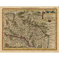
Alsatia inferior.
Handsome map of the region around Strasbourg featuring a decorative cartouche enclosing the title and scale. Fully engraved to illustrate the rivers, forests and mountain...
Place & Date: Amsterdam, 1631
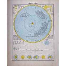
The Solar System.
The charts shows the comparative size of the Planets and the Sun, as seen from the Planets.
Place & Date: London, 1873
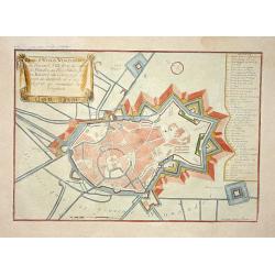
Berg st Winox.
Nice city plan of Winoxbergen with the fortification walls around the city.
Place & Date: Paris 1705
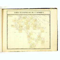
Troisiéme Partie - Afrique (from Atlas Universel de Geographie Physique, Statistique. . .)
"thought to be the first world atlas on a uniform scale and the first to be produced by lithography" (Tooley).The atlas has at the beginning an index map "...
Place & Date: Brussels, 1825-1827
GRENADA,- CARTE DE LA ISLE DE LA GRENADE DRESSE AU DEPOT .. 1760
Large antique French sea chart of the island of Grenada in the Caribbean Sea. Dated within the decorative title cartouche to 1760. Coverage includes several of the smalle...
Place & Date: Paris, 1760
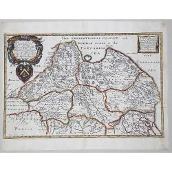
SIBERIA. - A General Mapp of the Kingdome of TARTARIA.
A partly colored copperplate map, essentially showing Siberia or the eastern part of the Russian empire in Asia, formerly called 'Tartaria' . The earliest folio sized map...
Place & Date: London, 1669
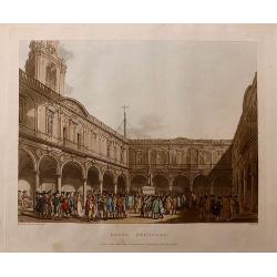
Royal Exchange, from the Microcosm of London.
A beautiful first edition colored aquatint view of the Courtyard of the Royal Exchange London, packed with City merchants. The 'Microcosm of London' was published in thre...
Place & Date: London, 1808
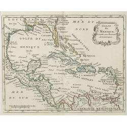
Golfe du Mexique . . .
Map of the Gulf of Mexico, from Atlas moderne portatif composé de vingt-huit cartes sur toutes les parties du globe terrestre .. A l'usage des Colléges, des Pensions &a...
Place & Date: Paris, Prudhomme, Levrault, Debray, 1806