Wish List
With WishList / Virtual Collection, you can save and collect your favorite items in one place, it is free and you can delete an item from your list at any time.
Save any of the 30.000+ maps, prints or Medieval manuscripts from our BuyNow Catalog or Catalog Archive.
Unless logged in, an item is only saved for that session. If you want to save the items permanently, please log in first.
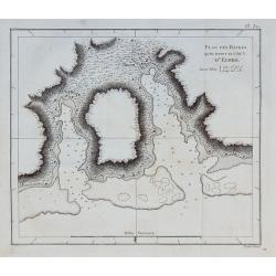
Plan des Havres qu'on trouve au côté N. d'Eimeo.
From the French edition of James Cook's third voyage entitled Troisième Voyage de Cook, ou Voyage à l'Océan Pacifique, ordonné par le Roi d'Angleterre, pour faire des...
Place & Date: Paris, 1785
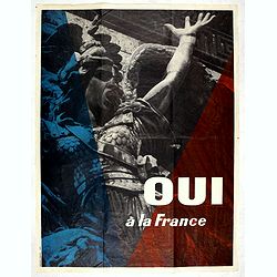
Oui à La France.
Vintage Gaullist poster against the French May 1968 events. The events of May 1968, refer to a period during which student demonstrations take place in France, as well ...
- $750 / ≈ €670
Place & Date: Paris, 1968
![Colding Schloss und Stat. [Kolding]](/uploads/cache/84690-250x250.jpg)
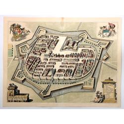
Colding Schloss und Stat. [Kolding]
A fine antique map - bird's eye view of Kolding/Denmark by Braun and Hogenberg. From the rare: Urbium Praecipuarum Mundi Theatrum Quintum Auctore Georgio Braunio Agrippin...
Place & Date: Cologne, 1596
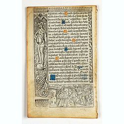
Leaf on vellum from a printed Book of Hours.
21 lines of printed text, surrounded by renaissance borders decorated with Saint Sebastian, a half naked woman, flowers and religious scenes.From the press of the leading...
Place & Date: Paris, Germain Hardouyn, c.1520-1540
Selling price: $80
Sold in 2023
![The Poisoned cup of Saint John. [from the Book of Hours in the Suffrages to the Saints].](/uploads/cache/25632-250x250.jpg)
The Poisoned cup of Saint John. [from the Book of Hours in the Suffrages to the Saints].
Painted scene of the Poisoned cup of Saint John. The biblical story goes that the Emperor Diocletian offered St. John a cup of poisoned wine. He survived because he bless...
Place & Date: France, ca.1300
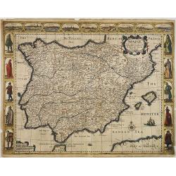
Spaine Newly described, with many adictions, both in the attires of the people & the Setuations of their cheifest Cityes by John Speed 1626.
From Speed's Prospect of the most famous parts of the world, here published by Roger Rea, the Elder. A decorative "carte à figures"- map of Spain and Portugal ...
Place & Date: London, 1626 / 1662-1667
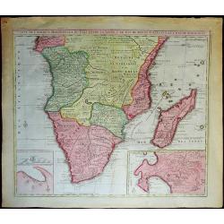
Carte de l'Afrique meridionale ou pays entre la ligne & le cap de Bonne Esperance et l'Isle de Madagascar.
An interesting and very large map of the southern part of Africa, from Gabon/Kenya to South Africa, with two inset maps: Table Mountain with a plan of Table Bay, and a ma...
Place & Date: Amsterdam, 1792
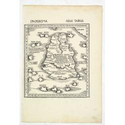
.Duodecima Asiae Tabula. (Taprobana - Sri Lanka)
Wood block printed large-format map showing present-day Ceylon / Sri Lanka. From the 1513 edition of Waldseemüller's Geographia.This Ptolemaic map comes from the first s...
Place & Date: Strasburg, 1513
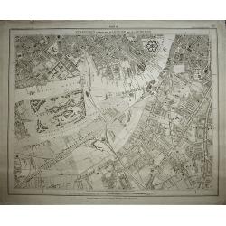
Stanford's Library Map of London and its Suburbs, sheet 14.
Published by Edward Stanford, 6 Charing Cross, London, February 15, 1862. Sheet no 14 covers Chelsea to Stockwell including Battersea Park Vauxhall Bridge and the Oval.
Place & Date: London, 1862
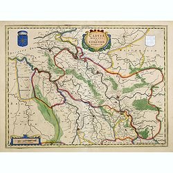
Clivia Ducatus et Ravestein Dominium.
A very decorative map with broad margins, showing a.o. the towns of Nijmegen, Venlo, Moers and Emmerich.
Place & Date: Amsterdam, 1647
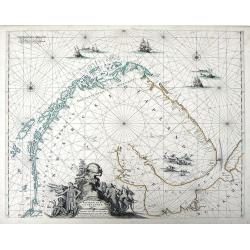
Finmarche et Laplandiae Maritima Nieuwe Pascaert vande Kusten Finmarcken en Lapland Streckende van Dronten tot Archangel.
Chart of the North and Barents Seas near the northern region of Finland and northeast Russia from Frederick de Wit's Zee Atlas. Coastal cities, bodies of water and island...
Place & Date: Amsterdam, 1675
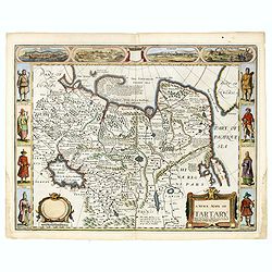
A newe mape of Tartary.
One of the most decorative maps of Tartary [i.e. Mongolia], known for its figured borders with costume figures, while above are vignettes of the cities of Astrakhan, Sama...
Place & Date: London, Bassett & Chiswell, 1627-1676

Typus Orbis Terrarum.
An antique oval world map by Barent Langenes, with cartography based on that of Ortelius, engraved by Jodocus Hondius, and published by P. Bertius in the pocket atlas “...
Place & Date: Amsterdam, 1606
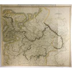
A Map of the Present Seat of War in the North of Europe.
A striking, detailed, uncommon and large, 1819 Laurie & Whittle's copperplate map of European Russia, at the time of the French Invasion of Russia. It extends to cove...
Place & Date: London, 1819
Selling price: $250
Sold in 2021
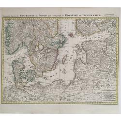
Seconde carte des Courones du Nord qui comprend le Royaume de Danemark.
Very nice antique map of the Baltic Sea Region with Denmark, Estonia and parts of Norway, Sweden, Finland, Russia, Latvia, Lithuania, Belarus, Poland and Germany, in fact...
Place & Date: Amsterdam, ca. 1742
Carmagnolia.
A very detailed copper engraving with lovely color. From Johannes Blaeu's scarce series of Italy town books. This is a map view of Carmagnolia (Carmagnola), published in ...
Place & Date: Amsterdam, 1663
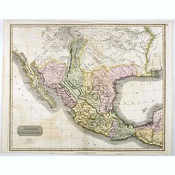
Spanish North America.
The excellent map by the Scottish engraver John Thomson, depicts Mexico from the Yucatan northwards to what would eventually become the Republic of Texas, and the Louisia...
Place & Date: Edinburgh, 1821

The Entry of Love and Wealth at Camacho's Wedding (together with) The Entry of Shepherds at Camacho's Wedding.
Two 18th century engravings Published by Robert Knaplock in London 1725 engraved by Gerard van der Gucht after Charles-Antoine Coypel.Cupid dancing in front of a castle w...
Place & Date: London, 1725
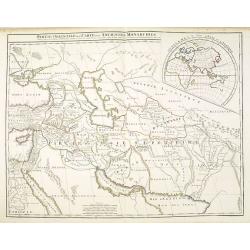
Partie Orientale de la Carte des Anciennes Monarchies. . .
This map depicts the eastern part of the Ancient World, Partie Occidentale de la Carte des Anciennes Monarchies including the Near East, Cyprus, Black Sea, Caspian Sea, I...
Place & Date: Paris, ca. 1800
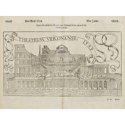
Theatrum Veronese 1549.
Early wood block print of the Theater in Verona. From his Geographia , that great compendium of Renaissance knowledge.The Cosmographia was one of the most successful and ...
Place & Date: Basle, ca. 1550
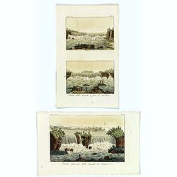
Veduta Generale della Cascata di Niagara / Veduta della Cascata a ferro di Cavallo &c.
A set of three small prints of the Niagara Falls and the Horseshoe cascade. Published in Giulio Ferrario's multi volumed work "Il Costume Antico e Moderno. . ."...
Place & Date: Milan, ca 1826
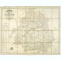
Carte topographique et routière du département de la Dordogne. . .
Detailed folding post road mapsroad map of the Dordogne, including Perigueux, lithographed by Thierry Frères. On the left a explicative legend about the road system. Wit...
Place & Date: Paris, 1839
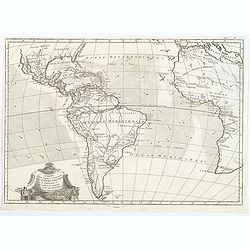
Carte pour servir a L'Histoire Philosophique et Politique des Etablissemens et du Commerce des Europeens dans les deux Indes.
A map more-or-less centered on South America, but also showing North America, Central America, the Caribbean, and at least half of Africa. Ocean currents are hatched with...
Place & Date: Paris, ca 1775
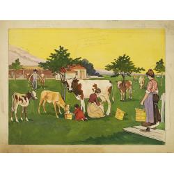
Milking cows.
Unsigned water color made as a model for a poster.
Place & Date: Belgium c. 1925
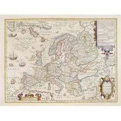
Nova Europae descriptio...
Very decorative map of Europe decorated with many ships and sea monsters.
Place & Date: Amsterdam, 1606-1630
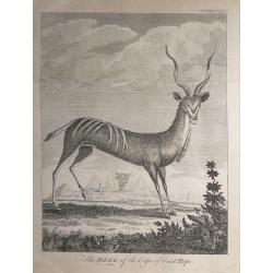
The Deer of the Cape of Good Hope.
From the Gentleman’s Magazine, September 1767.
Place & Date: London, 1767
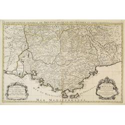
Le gouvernement général de Provencedivise en ses vigueries. . .
Fine map of the Provence with a decorative title and scale cartouche.Alexis-Hubert Jaillot (1632-1712), was a French cartographer. He joined the Sanson heirs and redrew N...
Place & Date: Amsterdam, 1692

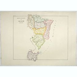
Nubia and Abyssinia.
Large scale map of Nubia and Abyssinia (Modern day Sudan & Ethiopia). The map shows an independent Darfur.Steel plate engraved map lithographed. From Johnston’s Nat...
Place & Date: Edinburgh, 1850
![[REPUBLIC OF SOUTH AFRICA] Set of 7 maps in plano format, on an uniform scale, covering the Republic of South Africa.](/uploads/cache/93850-250x250.jpg)
[REPUBLIC OF SOUTH AFRICA] Set of 7 maps in plano format, on an uniform scale, covering the Republic of South Africa.
A set of 7 plano sheet maps covering the Republic of South Africa, from Vandermaelen's famous Atlas Universel.It is to be noted that only a handful of these were made in ...
Place & Date: Brussels, 1825-1827
Africa Drawn and engraved from the best maps and charts.
Fine map of the continent of Africa.
Place & Date: London, 1771
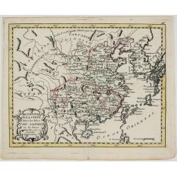
L’Empire de la Chine avec les Isles du Japon et le Coree.
Map of China, part of Japan, Korea, Tibet and Mongolia.Comes from rarely seen Jean-Baptiste Nolin atlas “Atlas Général a l’usage des colleges et maisons d’educati...
Place & Date: Paris, 1783
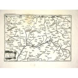
CARTE DU RETELOIS
Nice map from Tassin's desirable and scarce Atlas "Cartes generales de toutes les Provinces de France et d'Espaigne..." published by Berey in 1648. Very detaile...
Place & Date: Paris, 1648
![Homme Kamtschadale [together with] Femme Kamtschadale.](/uploads/cache/36922-250x250.jpg)
Homme Kamtschadale [together with] Femme Kamtschadale.
Set of two originally hand-colored mezzotints of Native Russians engraved by Félix Mixelle and Lachaussée Jeune after Jacques Grasset de Saint-Sauveur.As an etcher, dra...
Place & Date: Paris,1801-1806
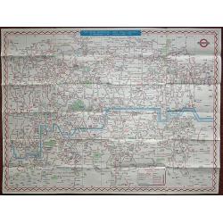
1946 Central London Bus map Fred J H Elston edition.
London Bus map Central Area issued by London Passenger Transport Board 1946 by Fred J H Elston. A comprehensive index on the verso
Place & Date: London 1946

Two childern eating candies.
Unsigned poster design.On verso a label of Etablissements O. De Rycker S.A. Ateliers d'Impressions d'Art Publicité. Forest Bruxelles.. Croquis N° 2852. O.DE Rycker was ...
Place & Date: Brussels c. 1930
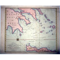
A Chart of the Ship's path from Candia to Cape Colonna. . .
A scarce nautical chart from the book: William Falconer, The Shipwreck, published in London, and printed for T. Cadell, 1772.The map depicts the track of the ship Falcone...
Place & Date: London, 1772
![[Lot of 4 maps] Amerique / Asie / Afrique / Europe.](/uploads/cache/48397-250x250.jpg)
[Lot of 4 maps] Amerique / Asie / Afrique / Europe.
A pleasing set of the four continents by Cortambert. The Americas map shows Alaska as Amerique Russe, there are inset maps of the Antilles in the Caribbean, plus an inset...
Place & Date: Paris, 1864
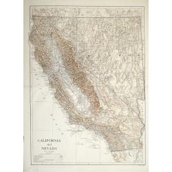
California and Nevada by Sir Emery Walker.
Early map of California with a scale of 1:3,500,000 English miles Published by Cambridge at the University press, London.
Place & Date: London, 1910
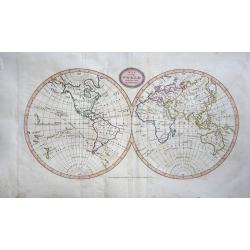
Map of the World from the Best Authorities.
An attractive map of the World in two hemispheres engraved by James Barlow with original hand coloring. Published by C. Brightly and J Kinnersley in Bungay Suffolk, Janua...
Place & Date: Bungay, 1807
ANGLIAE, SCOTIAE ET HIBERNIAE, SIVE BRITANNICAR: INSVLARVM DESCRIPTIO.
A beautiful map of the British Isles, north to the right. The map is based on Mercator's earlier map of the British Isles of 1564. Title in strapwork cartouche at top rig...
Place & Date: Antwerp, 1592
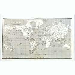
The World on Mercators Projection.
Basic world map based on Mercator's projection. Australia called 'New Holland', reference to the 'Gulf of Corea', the landmass of Greenland is distorted.
Place & Date: 1805
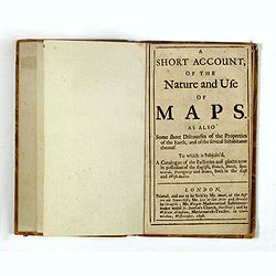
A Short Account of the Nature and Use of Maps. As Also Some short Discourses of the Properties of the Earth. . .
FIRST EDITION of a rare book about the nature of using maps. A second edition was printed in 1703. With chapters on "description of making and projecting of circular...
Place & Date: London, 1698
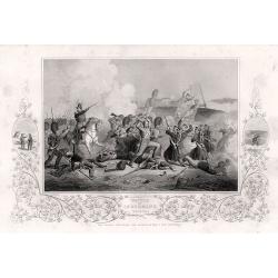
The Crimea war, 18 engravings depicting the Battles between the Russian Empire and several European powers for influence over territories of the declining Ottoman Empire, Nicholas I. Emperor of Russia and Military Leaders of the European Powers
An interesting set of 18 steel engravings depicting The Crimea war, the Battles between the Russian Empire and several European powers for influence over territories of t...
Place & Date: London, 1858
![Lutetia, vulgari nomine Paris, urbs Galliae maxima. . . [with French text on verso]](/uploads/cache/82158-250x250.jpg)
Lutetia, vulgari nomine Paris, urbs Galliae maxima. . . [with French text on verso]
Bird's-eye view of Paris from Braun & Hogenberg’s sixteenth century bestseller Civitates Orbis Terrarum.This is a beautiful example of one of the earliest modern pl...
Place & Date: Cologne, c. 1572-1580
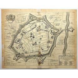
Crema ou Crème.
A striking plan of the town of Crema, in the Republic of Venice, now part of Italy. It is by Pierre Mortier in Amsterdam in 1720.It has the crest of the city, and a deta...
Place & Date: Amsterdam, 1708
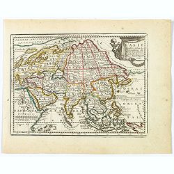
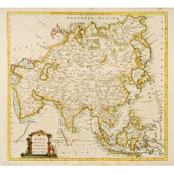
L' Asie Dressée Selon les Observations de Mrs. De l' Academie Royale des Sciences.
A delightful little map of Asia that conforms to the standard French model of the period. Hokkaido is attached to the mainland and Terre de Iesso is off the coast partial...
Place & Date: Paris, 1719
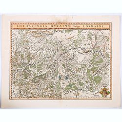
Lotharingia Ducatus vulgo Lorraine.
A very detailed map for his time centered on Nancy, Bayon and Metz, and including the river valleys of the Sar and Moselle. In the lower right-hand corner of the map is a...
Place & Date: Amsterdam, ca 1640
Selling price: $16
Sold in 2021
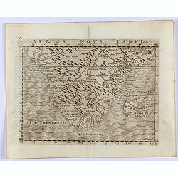
Africa Nova Tabula.
Gastaldi's modern map of the Southern part of Africa, Madagascar, etc. From Giacomo Gastaldi's Atlas of 1548 which has been called the most comprehensive atlas, produced ...
Place & Date: Venice, 1548
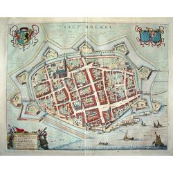
Salt Boemel
To the left the heraldic arms of Brabant and on the right the arms of Ravestein. From Joan Blaeu's town book. Novum Ac Magnum Theatrum Urbium Belgicae Liberae Ac Foederat...
Place & Date: Amsterdam, 1649
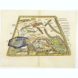
.Tabula septima Asiae.
This is a Ptolemaic representation of the extremely mountainous region east and northeast of the Caspian Sea. The dense mountains are further a barrier due to thick fores...
Place & Date: Vienne, 1541
![Salisbvrgensis Ivrisdictionis. [Salzburg].](/uploads/cache/81836-250x250.jpg)
Salisbvrgensis Ivrisdictionis. [Salzburg].
A beautifully colored example with a bold, sharp strike of the first issue of the first map of the Jurisdiction of Salzburg to appear in a modern atlas. The engraving is ...
Place & Date: Antwerp, 1570
![[Zürich], Tigurum, Zürych.](/uploads/cache/84273-250x250.jpg)
[Zürich], Tigurum, Zürych.
Decorative engraved copperplate engraving of Zürich. Title in the upper margin and large coat-of-arms on the right. With detailed legend and description of the buildings...
Place & Date: Frankfurt, 1646
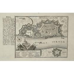
Riga
The exact title of this map is : Riga wie es A. 1700 aus dem Polnischen Lager communicirt worden. The map was made after an engraving by De Fer.
Place & Date: 1720
![[Lot of 11 maps and views of the Falkland islands and the Argentinian part of Terra del Fuega. ]](/uploads/cache/20422-(2)-250x250.jpg)
[Lot of 11 maps and views of the Falkland islands and the Argentinian part of Terra del Fuega. ]
Rigobert Bonne (1727-1795), French cartographer. His maps are found in a.o. Atlas Moderne (1762), Raynal's Histoire Philos. du Commerce des Indes (1774) and Atlas Encyclo...
Place & Date: Paris, 1762
Selling price: $200
Sold in 2022
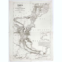
Karte der Hauptstraßen von der niederen Donau bis Constantinopel … / Spezialkarte des Meerbusens von Burgas . ..
Uncommon map of the routes of the eastern part of the Balkan Peninsula. prepared by C. Zirbeck The map has two insets "Meerbusen von Burgas oder Mesambri" (Bay ...
- $550 / ≈ €491
Place & Date: 1820
Divers ouvrages des habitans de l'Isle Sandwich.
From the French edition of James Cook's third voyage entitled Troisième Voyage de Cook, ou Voyage à l'Océan Pacifique, ordonné par le Roi d'Angleterre, pour faire des...
Place & Date: Paris, 1785
![[No title] Russland.](/uploads/cache/28944-250x250.jpg)
[No title] Russland.
Map depict the area north of the Black Sea, including the cities of Jekaterinoslaw, Bachmut, Alexandrowsk.From "W. E. A. von Schliebens Atlas von Europa nebst Koloni...
- $300 / ≈ €268
Place & Date: Leipzig, G. J. Göschen, ca 1825-1830
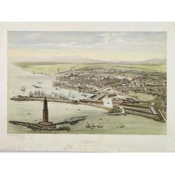
L'Italie à vol d'Oiseau / Livourne. Vue prise au dessus du Fanal.
A bird's eye view of the port city of Livorno ( or in English Leghorn ) on the Tyrrhenian Sea on the western edge of Tuscany.Draw and lithographed by A. Guesdon. Publishe...
Place & Date: Paris, Lemercier, ca. 1850
![West Indies [chart] from Belize to Cabo Catoche.](/uploads/cache/39479-250x250.jpg)
West Indies [chart] from Belize to Cabo Catoche.
An British Admiralty chart of a portion of the eastern coast of Belize (or British Honduras as it was) north to the northern most point, Cabo Catoche, on the Mexican Yuca...
Place & Date: London, 1839
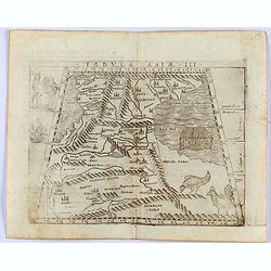
Tabula Asiae III
Gastaldi's map of the region between the Black Sea and Caspian Sea. Shows cities, towns, rivers and mountains. Includes an illustration of Noah's Arc in the Caspian Sea. ...
Place & Date: Venice, 1548
Province ecclesiastica di Besançon in Francia (Tav LVI)
This large-format Besançon map is finely engraved and beautifully colored and was prepared by Girolamo Petri, a lawyer who served as a senior official within the Vatican...
- $300 / ≈ €268
Place & Date: Rome, 1858
Partie Méridionale de la Russie Européenne, Tartarie, Russienne, Petite Tartarie.
Map of the southern part of Russia and Tartary. The Caspian Sea in lower right corner. By C. F. Delamarche, successor of Robert de Vaugondy, Geographer.
- $50 / ≈ €45
Place & Date: Paris, 1806
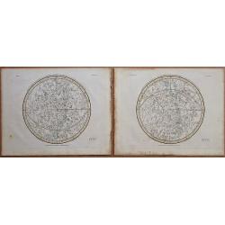
Stereographic Projection of the Southern Celestial Hemisphere on the Plane of the Equinoctial - Stereographic Projection of the Northern Celestial Hemisphere on the Plane of the Equinoctial.
A finely engraved and delicately colored pair of celestial charts by Alexander Jamieson engraved by Neele & Son. Alexander Jamieson published A Celestial Atlas Compri...
Place & Date: London, 1822
![Anacardium Occidentale. Westindische Elephanten Laub. [Cashew nut]](/uploads/cache/95777-250x250.jpg)
Anacardium Occidentale. Westindische Elephanten Laub. [Cashew nut]
Copper engraved print; overall size 36 x 22,5 cm from the German edition of Blackwell's 'Herbarium Blackwellianum...' or 'A Curious Herbal', originally published in Londo...
Place & Date: Nurnberg, 1757-1773
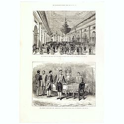
The attempt on the Czar's life: The Grand Ball-Room . . .
A panorama of the Winter Palace with an attempt on the Czar's life published in the Illustrated London News of 28 February, 1880.
- $15 / ≈ €13
Place & Date: London, 28 February, 1880
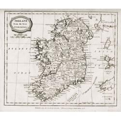
Ireland From The best Authorities.
Map of Ireland by J. Barlow, published by C. BRIGHTLY & T KINNERSLEY, Suffolk, March 1806.
Place & Date: London,1806
Partie Méridionale de la Russie Européenne, Tartarie, Russienne, Petite Tartarie.
Map of the southern part of Russia and Tartary. By C. F. Delamarche, successor of Robert de Vaugondy, Geographer.
- $90 / ≈ €80
Place & Date: Paris, 1806
Les Provinces, ou Gouvernement de Poictou, d'Anjou, du Maine, De Touraine . . .
Map centered on Loire region, with Blois, Saumur, Sancerre and Orleans, from Nicolas de Fer's "L'Atlas curieux ou le Monde réprésente dans des cartes. "The &q...
Place & Date: Paris, 1705
Gouvernement de Dauphiné, Generalité de Grenoble.
Map of the Dauphiné region, from Nicolas de Fer's "L'Atlas curieux ou le Monde réprésente dans des cartes. "The "Atlas Curieux" is a geographic enc...
Place & Date: Paris, 1705
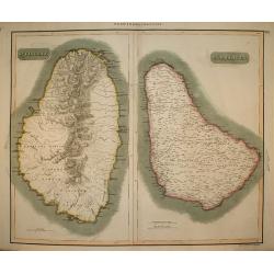
West India Islands: St. Vincent & Barbadoes
Undated copper-engraved map, c. 1815, for Thomson's New General Atlas.
Place & Date: Edinburgh, c.1815
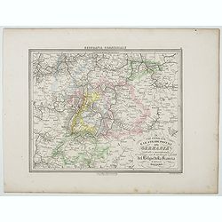
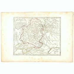
Le Vie Ferrate e le Strade Postali della Germania centrale e meridionale . . .
Uncommon map of Germany and part of France and Switzerland prepared by Francesco Costantino Marmocchi. Above the map "Geografia Commerciale". From "Il Glob...
- $25 / ≈ €22
Place & Date: Genova, Paolo Rivara fu Giacomo, 1858
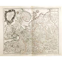
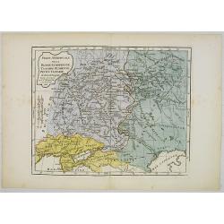
Partie Septentrionale de la Russie Europeenne ou sont distinguees exactement toutes les Provinces, d'apres le detail de l'Atlas Russien, Par le Sr. Robert de Vaugondy fils, Geog. Ordin? Du Roi.
Detailed map of northern European Russia, including Finland. The map was first published by the Venetian cartographer and publisher François (Père) Santini and first pu...
Place & Date: Venice, 1784
Disegno Idrografico del Canale Reale . . .
A decorative Coronelli map showing the Canal du Midi. It shows the extent of the canal from the Mediterranean sea at Narbonne to Toulouse. Featuring a pair of large coats...
- $300 / ≈ €268
Place & Date: Venice, 1695-1697
Russie d'Europe avec la partie la plus peuple de celle d'Asie...
A detailed map covering what was 'Russia in Europe', toward the end of the eighteenth century. Decorated with a decorative title cartouche, and an 'Advertisement'.Boundar...
- $150 / ≈ €134
Place & Date: Paris, ca 1783
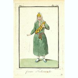
Femme Tschouwache.
Originally hand-colored mezzotint from 'Costumes civils actuels de tous les peuples connus' engraved by Félix Mixelle and Lachaussée Jeune after Jacques Grasset de Sain...
- $30 / ≈ €27
Place & Date: M. Sylvain Maréchal. Paris, 1788
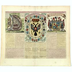
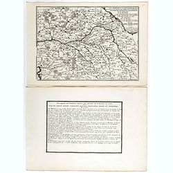
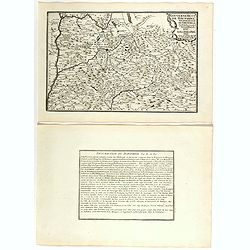
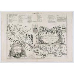
Carte du gouvernement civil ecclésiastique de moscovie, l'état des revenus et l'ordre de la justice et des officiers de la cour.
Interesting sheet with a detailed plan of Moscow, plus two large coats-of-arms, with descriptive French text, from Chatelain's monumental 7 volume Atlas Historique. In up...
- $950 / ≈ €849
Place & Date: Amsterdam, 1720
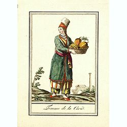
Femme de la Carie.
Originally hand-colored mezzotint costume plate of a woman from the Republic of Karelia, engraved by Félix Mixelle and Lachaussée Jeune after Jacques Grasset de Saint-S...
Place & Date: Paris,1801-1806
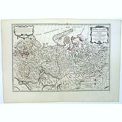
Governo di Arcangelo, e sue Provincie Nella Russia Europea . . .
Map shows the island Nova Zembla and the government of Archangel, Jarensk and Chlynow. Engraved by G. Zuliani and G. Pitteri.Published in Zatta's "Atlante Novissimo&...
- $375 / ≈ €335
Place & Date: Venice, 1782
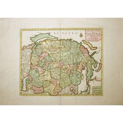
Nieuwe Kaart van Tartarie..
This is a very handsome and detailed chart of the northern regions of Asia reflecting the recent discoveries in Kamchatka by Witsen with the icy cape Kaap Suetoinos, whic...
Place & Date: Amsterdam, 1760
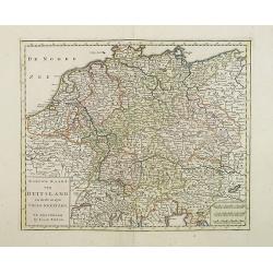
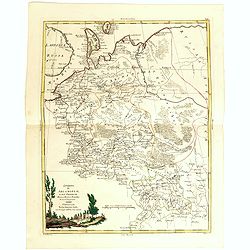
Nieuwe Kaart van Duitsland..
Detailed map of Germany, including The Netherlands, Belgium, Luxembourg, Switzerland and Austria. Isaac Tirion was born in Utrecht ca. 1705. He came to Amsterdam ca. 1725...
- $120 / ≈ €107
Place & Date: Amsterdam, 1747