Wish List
With WishList / Virtual Collection, you can save and collect your favorite items in one place, it is free and you can delete an item from your list at any time.
Save any of the 30.000+ maps, prints or Medieval manuscripts from our BuyNow Catalog or Catalog Archive.
Unless logged in, an item is only saved for that session. If you want to save the items permanently, please log in first.
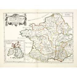
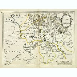
Antiquorum Galliae episcopatuum geographica descriptio. . . / Antiqui magnae Britaniae Episcopatus.
Detailed map of France during Ancient times. In lower left corner inset map of England "Antiqui magnae Britaniae Episcopatus." (160x146mm.) First published in &...
- $120 / ≈ €107
Place & Date: Paris, ca.1641
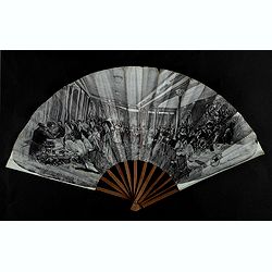
Les nuits du Rat Mort.
Fan for Rat Mort (Dead Rat) restaurant, in Montmartre, Paris. Representing the room of the Rat Mort starting from a retouched photograph showing the couples seated with i...
Place & Date: Paris, 1905
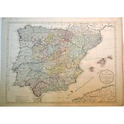
Karte von Spanien nach der neuen Karte von Lopez …..
A large map from the 'Atlas der Neuen Geographie von der ganzen bekannten Erde', plate # 6. With a circular text cartouche. Schneider & Weigel in Nuremberg were ...
Place & Date: Nuremberg, 1804
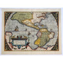
Americae Sive Novi Orbis, Nova Descriptio. 

A very fine example of Ortelius' map showing the western hemisphere with the prominent bulge in the South American coastline. No text on verso. The second copperplate on ...
Place & Date: Antwerp, 1579
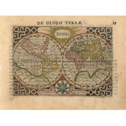
Jehova (Worldmap)
Double-hemisphere. Engraved by Jodocus Hondius. With "Iehova" shown at top center. Letterpress text in upper margin: "De Globo Terrae". Later issue of...
Place & Date: Amsterdam 1600-1606
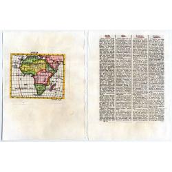
Afrika
From : Schauplatz der Natur und Kuenste, in vier Sprachen, deutsch, lateinisch, franzoesisch, und italiaenisch. [An exhibition of Art and Nature, in four Languages, Germa...
Place & Date: Vienna, 1781
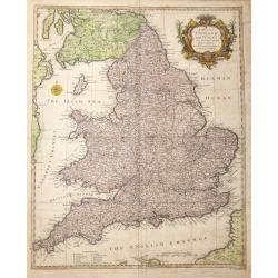
A Map of England and Wales from the latest and best Observations; For Mr Tindal's Continuation of Mr Rapin's History
An attractive map with decorative title cartouche embellishing upper right.This highly detailed map shows England & Wales with part of Scotland and its position with ...
Place & Date: London, 1745

A View of the Exchange and the Warehouses at Petersburg in Russia.
Beautiful engraving of the St. Petersburg stock exchange engraved for Middleton’s Complete System of Geography. Robert Sayer (1725–1794) was a leading publisher and ...
Place & Date: London, 1780
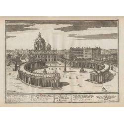
L\'Eglise de St. Pierre à Rome.
Engraving of the St. Peter's Basilica in Rome.From De Fer's Atlas Curieux.
Place & Date: Paris, 1705-1717
![[2 x maps] Western Division of Paris. Containing the Quartiers and Eastern Division of Paris. Containing the Quartiers.](/uploads/cache/83157-250x250.jpg)
[2 x maps] Western Division of Paris. Containing the Quartiers and Eastern Division of Paris. Containing the Quartiers.
An attractive pair of steel plate plans of Paris that show the entire city in remarkable detail. Along the bottom are a total of 24 elevation views of important buildings...
Place & Date: London, 1834

Pseudo Narcissus pallidus calice amplo. / Pseudo Narcisus simplex Belga. / Pseudo Narcissu aureus praecox.
Beautiful narcissus from the first edition of the Hortus Eystettensis, printed and issued by Basilius Besler in Nuremberg 1613. This year is the 400 anniversary of the fi...
Place & Date: Nuremberg, 1613
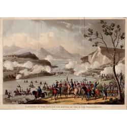
Napoleon at the Passage and Battle of the River Tagliamento.
Engraved by George Cruikshank from the original design of C. Vernet, executed at Paris by I. Duplessi Bertaux.Published on September 11th, 1823, by John Fairburn, Broadwa...
Place & Date: London, 1823

Sale du Grand Conseil de Venise....de Pierre Mortier Libraire. A Amsterdam.
Copper engraved print; overall size 58 x 70 cm, from Abraham Nicolas Amelot de la Houssaie's 'Histoire du gouvernement de Venise', publ. by Pierre Mortier, Amsterdam, c17...
Place & Date: Amsterdam, ca. 1705
Europa delineata et recens edita.
"Among the many great Dutch map publishers active in the seventeenth century were the Visscher family, begun by Claes Jansz Visscher (1587-1652) and continued by his...
Place & Date: Amsterdam 1656-1677

St. Thomas's Hospital (together wit) Christ's Hospital. (2 engravings)
Both engravings are copper plate engravings by William Henry Toms, published in "Maitland’s History of London" in 1738.
Place & Date: London, 1738
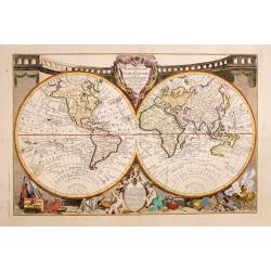
Mappemonde ou globe terestre
Scarce and decorative world map with all the major early explorers. Jean Baptiste Louis Clouet (born 1730) was a member of the Academie Royale des Sciences de Rouen and t...
Place & Date: Rouen, 1787
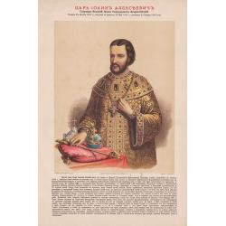
Tsar Ioann Alekseevich.
A portrait of Tsar Ioann Alekseevich, from the very rare Rossiiskii Tsarstvennyi Dom Romanovykh (Russian Tsarist House of Romanov), published by Izdanie K. A. Borozdina.
Place & Date: Moscow, 1896

Vietnam Festveranstaltung … Jane fonda Indochine peace campaign, Ho X. De . . .
Poster for the Berlin 1974 festival organized by the Indochina Peace Campaign movement.The Indochina Peace campaign (IPC) was an antiwar organization founded in 1972 by ...
Place & Date: Germany, 1974
![Sivillia [Sevilla].](/uploads/cache/85201-250x250.jpg)
Sivillia [Sevilla].
A wonderful view on the city of Sevilla (Spain). The river Guadalquivir in the foreground with travellers, an inn, and salesmen on its bank, many ships on the city side o...
Place & Date: Amsterdam, ca 1680
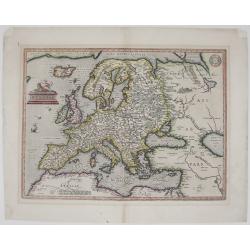
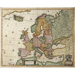
Europae
Nice colored Ortelius’ map of Europe. This is the second edition, which was first issued in 1584 and can be distinguished from the earlier editions by the inclusion of ...
Place & Date: Antwerp, 1598
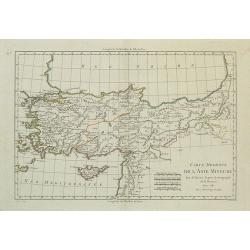
Carte Moderne de l'Asie Mineure.
Small and appealing map of Asia Minor, including Cyprus. Shows many cities and towns, as well as the ruins of Troy and Ephesus. The Black Sea coast is still not well kno...
Place & Date: Paris, 1781
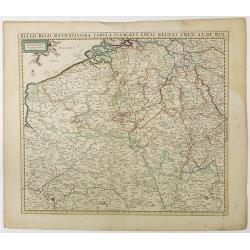
Belgii Regii Accuratissima Tabula Pluribus Locis. . .
Covering present-day Belgium, Luxembourg, Noord Brabant an Limburg in the Netherlands, and northern part of France.
Place & Date: Amsterdam, 1680
Selling price: $30
Sold in 2023
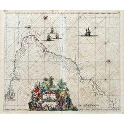
Littora Brasiliae
Important sea-chart, oriented with north to the left. Shows the area of the Brazilian coastline from the mouth of the Amazon until the Rio de la Plata in Argentina. A sup...
Place & Date: Amsterdam, ca. 1675

Bombario, o dood! Te schendig in nood.
Decorative print satirizing the stock exchange speculative crisis business after it collapse in the beginning of the 18th century, that led to the complete ruin of many o...
Place & Date: Amsterdam, 1720
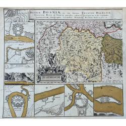
Regnum Bosniae, una cum finitimis Croatiae, Dalmatiae, Slavoniae,...
Left sheet only of this famous map. Centered on Bosnia and surrounded with 8 town plans: Ussitza, Brodt, Wihaz, Zwornek, Ratscha, Sabatz, Belgrade, and Orsava.
Place & Date: Nuremberg, ca. 1740
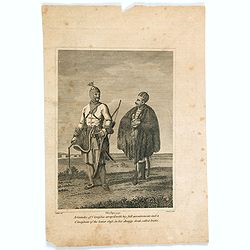
A Grandee of Circassia with his full accoutrements and a Cirassian of the lower class. . .
A small early nineteenth copperplate engraving of two Circassian men, one of higher rank than the other, in their respective costumes. Circassians are a Northwest Caucasi...
Place & Date: London, ca 1817

Leaf on vellum from an antiphonary.
A large vellum antiphonary leaf, written in Latin, probably Rome. RECTO: A wonderful initial ,Q, decorated with pen work in red, white and blue, in rich burnished gold.VE...
Place & Date: Italy, 1480
Selling price: $450
Sold in 2024
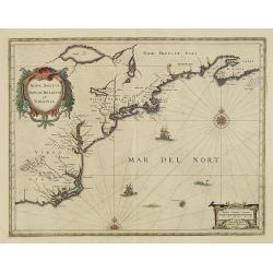
Nova Anglia Novum Belgium et Virginia.
In the 1636 edition of the Appendix, Johannes Janssonius inserted this important and influential map of the eastern seaboard from C. of Feare (Cape Lookout) to Nova Scoti...
Place & Date: Amsterdam, 1636

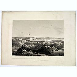
Winter Village of the Minatarres.
During the winter of 1833-34, Bodmer traveled some distance from Fort Clark to one of the Hitatsa winter villages, where he stayed for a few days.In this scene, a number ...
Place & Date: Pars, Coblenz, London, 1839
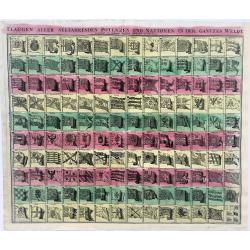
Flaggen aller Seefahrenden Potenzen und Noationen in der gantzen Welt...
Striking example of the famous Flag print produced by Homann. The chart illustrates 139 flags of various nations, factions, and trading companies, including the flags of ...
Place & Date: Nurenberg, 1730

Doctor Syntax setting out in search of a wife.
Charming title page for "Doctor Syntax.. .. in Search of a Wife .. Printed by R. Ackermann.
Place & Date: London, 1823
Selling price: $10
Sold in 2023
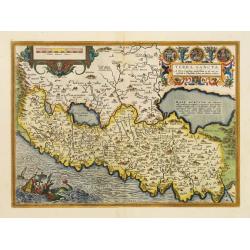
Terra Sancta.
This is the most modern of Ortelius' maps of the Holy Land. It focuses specifically on the Holy Land and is oriented with east of the top. Ortelius used as a model the wa...
Place & Date: Antwerp, 1595
Selling price: $600
Sold in 2022

Plan, Section and Elevation of the Poo-Ta-La or Temple of the Lama at Zhe-Hol in Tartary.
A striking copper engraving from an important eighteenth century series on China by William Alexander. From Sir George Leonard Staunton's An Authentic Account of an Emba...
Place & Date: London, 1796
Selling price: $13
Sold in 2023
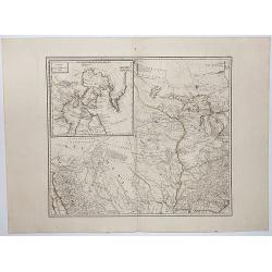
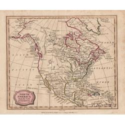
GENERAL MAP OF NORTH AMERICA.
This map is the upper left portion of a 4-sheet map of North America, featuring the northwestern part of North America, and includes an inset map of Baffin and Hudson Bay...
Place & Date: Vienna, 1788
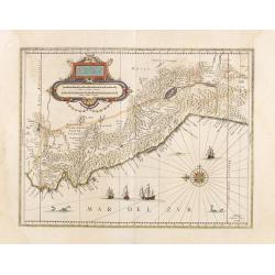
Peru.
Decorated with ships and monsters on the sea. Orientated with east at the top. Shows the Pacific coast of South America from Ecuador (at the left-hand side) as far south ...
- $400 / ≈ €357
Place & Date: Amsterdam, 1658
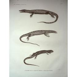
Plate of Three Lizards, from the reptiles volume of Napoleon's Description de l\'egypte.
A huge plate - imperial folio size - from the Second edition (1821-1828) of the reptile volume of Napoleon's "Description de l'Egypte. This is plate 3b, entitled &qu...
Place & Date: Paris, 1821-1828
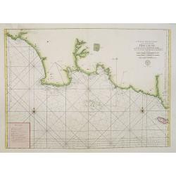
6.me Carte Particuliere Des Costes De Bretagne Depuis la Baye D'Hodierne Jusqu' a L'Isle de Groa..
Large-scale sea chart covering the coast of Brittany. With rhumb lines.Published by the Depot Générale de la marine with stamp and Prix. Trente Sols.
Place & Date: Paris, ca 1700
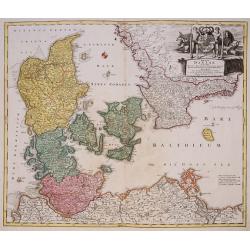
Regni Daniae, in quo sunt Ducatus Holsatia ...
Johann Baptist Homann's well-engraved map of Denmark, Schleswig-Holstein and Mecklenburg in Germany. With a fine decorative title cartouche.Johann Baptist Homann (1663-17...
Place & Date: Nuremberg, 1744

Donna dell' Isola di Pasqua, o terra di Davis nel Mar del Sud. / Femme de l' Isle de Pâques ou terre de Davis dans la Mer du Sud.
Full portrait of a woman, a native of the Easter Island. From "Raccolta di ? stampe." a series of historically significant eighteenth-century copper plate engra...
- $350 / ≈ €313
Place & Date: Venice, Antonio Zatta, c.1790
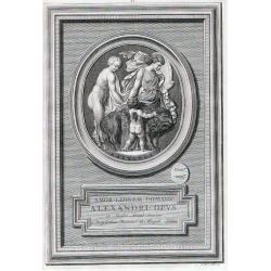
AMOR . LEONEM . DOMANS . ALEXANDRI . OPUS . ex Sarden Anagt Excisum ex Dactyiotheca Viccomit de Morpeth Londini
Print by Bernard Picart (1673 Paris - 1733 Amsterdam),for "Priamvs Aetionis Opvs, Gemmae incisum In Pasta apud Phillp de Stosch".Bernard Picart (1673 Paris - 17...
Place & Date: Paris, 1719
Junction of the Yellow Stone River with the Missouri.
An aquatint engraving done near Fort Union, just above the junction of the Yellow Stone and Missouri Rivers Fort Union was the uppermost point of steamer travel, and like...
Place & Date: Pars, Coblenz, London, 1839
![Plan of Banta [together with] and Bantem Bay.](/uploads/cache/83768-250x250.jpg)
Plan of Banta [together with] and Bantem Bay.
1. Clear view of the city of Banta. The Houtman ships finally arrived at Banten, a northwestern port in Java. Houtman was introduced to the Sultan of Banten, who promptly...
Place & Date: Amsterdam, 1611
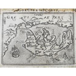
Corcyra vel Corfu
Unusual edition of this early miniature map of Corfu. With a sailing ship and a sea-monster. Latin title above the map.
Place & Date: Antwerp, ca. 1600
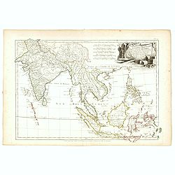
Les Indes Orientales et leur Archipel. . .
General map of Indonesia, extending from India to the Philippines and New Guinea.Ornated with a decorative title cartouche. Boundaries outlined in hand color.From theAtla...
- $250 / ≈ €223
Place & Date: Paris, ca 1783
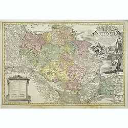
Principatus Silesiae Oelsnensis in suos Districtus Oels Bernstadt et Trebnitz divisi exactissima Tabula geographica, exhibens insimul. . .
Detailed map centered on Rawitsch, Freyhan, Adelnau, Mittelwalde, Gr.Wartenberg, Kempen, Pitschen, Kreuzberg in Oberschlesien, Ohlau and Breslau. Published in Atlas Siles...
Place & Date: Nuremberg, 1750
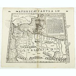
Aphricae Tabula I. (Mauritania - present-day Morocco, Algeria, and Tunisia.)
Double-page woodcut Ptolemaic-style map by Sebastian Münster figuring Mauritania, present-day Morocco, Algeria, and Tunisia, published in the edition of Strabo by Henri ...
Place & Date: Basle, Henri Petri, 1571
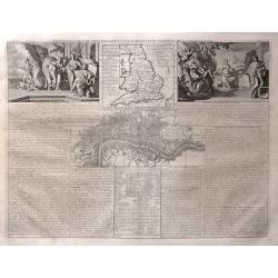
Nouvelle Carte du Gouvernement Civil, d'Angleterre et de celuy de la Ville de Londres.
An interesting copperplate map from Chatelain's "Atlas Historique", devoted to the government of England with panels of descriptive French text, and two scenes ...
Place & Date: Amsterdam, 1720
![[Taoism religion of the Callmoucks].](/uploads/cache/25834-250x250.jpg)
[Taoism religion of the Callmoucks].
Aquatint depicting six Taoist deities engraved by D.K. Bonatti, after drawings by C. Bottigella. Plate N° 43. The Tatars people which live almost all in the north of Asi...
- $45 / ≈ €40
Place & Date: Milan, 1827
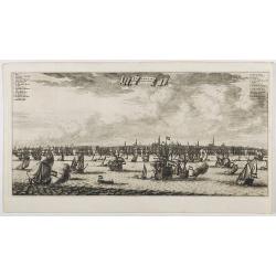
Amsterdam aan de Waterkant vanaf 't IJ te Sien.
A panoramic view of the town from 't IJ. Engraved by Daniël Stoopendaal.Dare to go in Black. All early maps were printed in black and white; many were kept that way for ...
Place & Date: Amsterdam, 1694
Selling price: $300
Sold in 2023
![[Lot of 7 maps of the lands bordering the Red Sea]](/uploads/cache/20680-250x250.jpg)
[Lot of 7 maps of the lands bordering the Red Sea]
Jan Elwe’s re-issue of Guillaume de l’Isle’s 1707 map of the lands bordering the Red Sea, showing Arabia distinctively.Jan Berend Elwe. Amsterdam-based publisher. P...
Place & Date: Paris, 1792
Selling price: $200
Sold in 2022
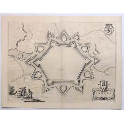
Grolla.
An exquisite town plan of Grolla in Holland, shown via a panoramic birds-eye view, it features the fortress and the surrounding pastoral landscape, and includes a coat of...
Place & Date: Amsterdam, 1649
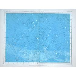
An attractive set of six celestial plates.
An attractive set of six celestial plates. A series of illustrations of the 'Heavenly Bodies.' A collaboration of the cartographer Alexander Keith Johnston and the astron...
Place & Date: Glasgow, 1877
Plan géométrique des environs de Nice, de Monaco, et de Menton.
Folding-map of the Nice, Monaco and Menton viccinities. A traveler's guide. On the upper left a cartouche stating different observations. Engraved by Erhard, geographer a...
Place & Date: Paris, 1870
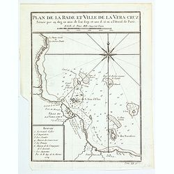
Plan de Rade et Ville de la Vera Cruz.
Bellin’s map of the port of Vera Cruz, Mexico which appeared in Prevost's "L'Histoire Generale des Voyages". This detailed map shows the Port of Vera Cruz in ...
Place & Date: Paris, 1754
Impero della China Colle Isole del Giappone.
China, Korea and Japan, with a decorative title cartouche.
Place & Date: Venice, 1784
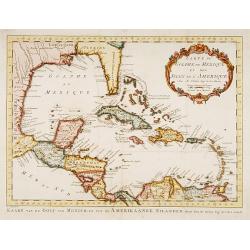
Carte du Golphe du Mexique et des Isles de L'Amerique.
Uncommon edition of this fine map of the Gulf of Mexico.From Atlas Portatif pour servir a l'intelligence de l'Histoire Philosophique et Politique des etablissements et du...
Place & Date: Amsterdam 1773
![Tabula Asiae III [Black & Caspian Sea Region]](/uploads/cache/41831-250x250.jpg)
Tabula Asiae III [Black & Caspian Sea Region]
Attractive woodblock Ptolemaic map, depicting Armenia and in the Right part of the Caspian Sea with Noes Arch, believed to have come to rest in a mountain in Armenia acco...
Place & Date: Basel, Heinrich Petri, 1545
Marah Fontes Amari.
Magnificent bird's eye- of the springs of Marah. Landscape with several small ponds and people collecting water in foreground, a caravan on a road between two mountains i...
Place & Date: Antwerp, c.1690
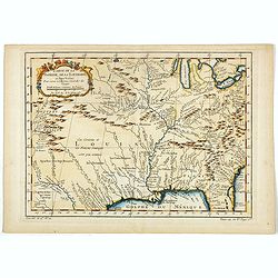
Carte de la Floride, de la Louisiane, et Pays Voisins. . .
Jacques Nicolaas Bellin (1703-1772) was one of the most important and proficient French cartographers of the mid-eighteenth century. He was appointed the first Ingenieur ...
Place & Date: Paris, 1757
![[Departure of Hans Staten from Lisbon].](/uploads/cache/39418-250x250.jpg)
[Departure of Hans Staten from Lisbon].
This print depicts the harbour scene, illustrating the departure of Hans Staden from Lisbon in 1547, when he set sail aboard a ship bound for Brazil, under the command of...
Place & Date: Frankfurt, 1607
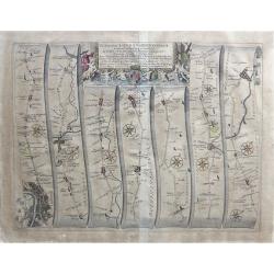
The Road From London to Buckingham.
This antique strip map is from the "Britannia" by John Ogilby, first published in 1675 with later hand coloring. This map is Number 12 of 100 maps in the atlas ...
Place & Date: London, 1675
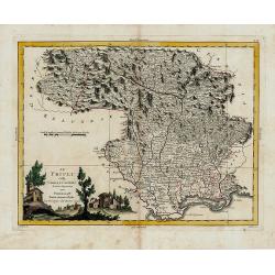
Il Friuli colla Carnia e il Cadorino di nuova Proiezione.
North-eastern Italy by Zatta, taken from his Atlante Novissimo . . published in Venezia in 1784, but engraved in 1783 (this date is printed on the map). Blank verso.
Place & Date: Venezia, 1784
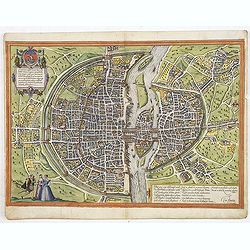
Lutetia, vulgari nomine Paris, urbs Gallia...
Beautiful and early town-plan of Paris with title cartouche and figures in the foreground. The Bastille is shown at the upper center of the engraving and the Notre-Dame c...
Place & Date: Cologne, ca. 1572
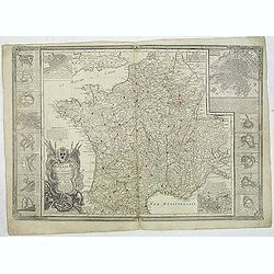
La France, divisée en ses principaux gouvernements. Avec toutes les Routes de ce Royaume. . .
Uncommon map of France with 16 inset plans of the major towns in France. Each town with a few lines of comment about their beauty, longitude and latitude and distance fro...
Place & Date: Paris, 1782
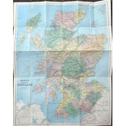
The Tourist's New Map of Scotland.
Attractive pocket map of Scotland, superbly detailed. Inset map of the Orkney and Shetland Islands. Folding into green covers with gilt title.
Place & Date: London, ca. 1890
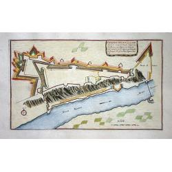
Les Souverainetez de Sedan et de Raucourt et la Provosté de Doncheri 1642.
A decorative map of Principauté de Sedan prepared by Jean Boisseau. The address mentions "A Paris chez I.Boisseau, Enlumineur du Roy pour les Cartes Geographiques, ...
Place & Date: Paris, 1642

Lovenstein.
A very nice view of the castle. On the sky, three hands holding a quill, a stone and a stick are depicted. With a verse in two languages underneath the picture.The poet D...
Place & Date: Frankfurt, 1623-1678
Selling price: $15
Sold in 2023

Indien Corbeau.
A watercolor of an Crow Indian by H.Thomas. The Crow Tribe of Indians is currently located in south-eastern Montana. The Crows are of Siouan origin, speaking a language c...
Place & Date: America, c. 1920
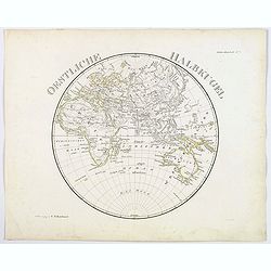
Oestliche Halbkugel.
A circular map of the eastern hemisphere, published in Steiler's Hand-Atlas in 1831. In German, each continent colored in outline.
Place & Date: Gotha, 1831
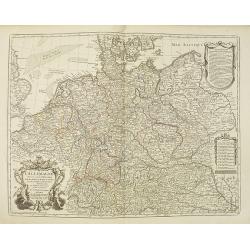
L'Allemagne dressée sur les observations. . .
Map of Germany, Low Countries, Poland, Switzerland, Northern Italy. Prepared by G.De L'Isle after observations by Kepler and Tycho Brahe.Engraved by Jean Batiste Liébaux...
- $300 / ≈ €268
Place & Date: Paris, 1788
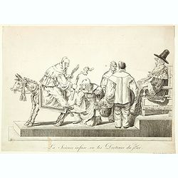
La Science infuse, ou les Docteurs du jour.
Demonstrating the innate knowledge of science, a man is sitting backwards on a donkey holding its tail in one hand and a candle in the other, another man is about to admi...
Place & Date: Paris, 1860
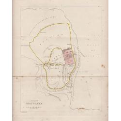
Ancient Jerusalem (Holyland)
A modest bird's-eye plan of Ancient Jerusalem that details the countryside, and all major areas, and shows the three walls of the city. Important buildings such as the te...
Place & Date: London, 1844
Inferior Germania.
Small map of the Benelux, centered on the Netherlands. Surrounded by text in Dutch. Included in the rare book : Wereld Spiegel, waer in vertoontword de Beschryvinge der R...
Place & Date: Amsterdam, Cloppenburch, 1621
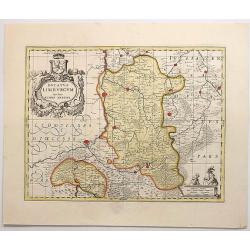
Ducatus Limburgum Auctore Aegidion Martini.
A striking decorative map of the province of Limburg in present The Netherlands and Belgium that is centred on the Meuse (Maas) River and the cities of Huy, Liege, and Ma...
Place & Date: Amsterdam, 1720
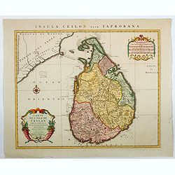
Carte de L'Isle de Ceylan. . . / Insula Ceilon olim Taprobana.
A fine large format map of Ceylon / Sri Lanka, as published by Covens & Mortier in Amsterdam. The map is based upon Guillaume De L'Isle's earlier map of Sri Lanka, an...
Place & Date: Amsterdam, 1742
![[Title page for ] Grosser Atlas with inset of North Pole projection map.](/uploads/cache/48579-250x250.jpg)
[Title page for ] Grosser Atlas with inset of North Pole projection map.
Title page from Grosser Atlas printed by Johann Ernst Udelbulner. Printed in red and black, with a map of the North Pole in lower part.Johann Baptist Homann born in Kamml...
Place & Date: Nuremberg, 1731
North America, from the Best Authorities
"North America, from the Best Authorities. "An attractive small map of the whole of North America engraved by James Barlow, with original hand coloring. Publish...
Place & Date: Bungay, 1806
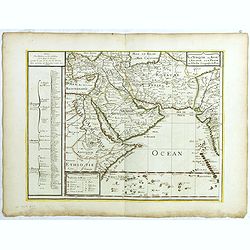
La Turquie en Asie, l'Arabie et la Perse.
Uncommon map centered on Arabian Pen Insular and Turkey, Cyprus, Palestine, Iran, Iraq, with Mer del Catif Golfe de Bassora. The map shows an extensive layout of traderou...
Place & Date: Paris, 1684
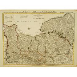
Carte De Normandie ou sont marquez exactement Les Pays ou Contrees enfermées dans cette Province..
Highly detailed map of Normandy, in north-western France. Beautifully engraved with a large compass rose and table of explanatory text. Shows illustrated topography with ...
Place & Date: Amsterdam c. 1745