Subscribe to be notified if similar examples become available.
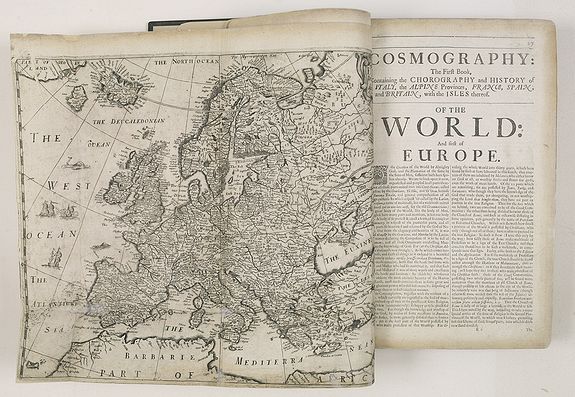
Cosmography in Four Books. Containing the Chorography and History of the Whole World, and all the Principal Kingdoms, Provinces, Seas, and Isles thereof. |
||||||||||||||||||||
|
||||||||||||||||||||
|
|
||||||||||||||||||||
Estimated value: $1800 - $1800 |
Virtual Collection - Save and collect your favorite items in one place.
Unless logged in, the item is only saved for that session. If you want to save the items permanently, please Login first Learn more [+] |
|||||||||||||||||||
Description
He took holy orders in 1624 and proceeded with theological studies. Heylyn was an "acrimonious controversialist" (Compact DNB ), who became embroiled in many theological disputes, and his enemies succeeded in removing him several times from ecclesiastical posts. On one of these occasions, after he had been interrogated by a commons' committee, someone told him "geography is better than divinity," and he began to work on an enlarged edition of his Microcosmos , called Cosmographie (London, Henry Seile, 1652).
The work opens with a general introduction to geography, followed by two books on the history and geography of Europe, book three deals with Asia, whereas Africa (book four part one) and America (book four part two) conclude the description of the known world.
The present edition closes with an Appendix to the Former Work, Endeavouring a Discovery of the Unknown Parts of the World: Especially of Terra Australis Incognita, or the Southern Continent . According to JCB , p. 473, the Appendix appeared for the first time in the edition of 1657. Interestingly, it does not appear in Mendelssohn's copy (I, pp. 710-711) of the fifth edition.
The Appendix has been little noted by bibliographers but is especially interesting. Heylyn deals with the unknown territories on the globe, where no "Knight Errant" ever set foot before. He divides the unknown areas into Terra Incognita Borealis, i.e. the north pole and the northern regions of America and Russia on the one hand, and Terra Incognita Australis, that is, unknown parts in the southern hemisphere on the other, and ventures to summarize the known facts as well as fictitious accounts on these territories.
The Australian continent supposedly matches the size of Europe, Africa and America combined (a consequence of the antipode theory), and Heylyn wonders, "The Countrey being so large, so free from the Incumbrances of Frosts and Ice and endless Winters, I have oft marvelled with my self that no farther progress hath been made in Discovery of it." Heylyn discusses the findings of explorers as Quiros, Magellan, Hawkins, Lemaire, etc., and deals with Terra del Fuego, the Solomon Islands, and New Guinea.
The Appendix section concludes, humorously, "And therefore I try my fortune, and without troubling the vice-Roys of Peru and Mexico or taking out Commission for a new Discovery, will make a search into this Terra Australis for some other Regions, which must be found either here or no-where." He continues to name them: Mundus alter & idem, "Another world, and yet the same, is a witty and ingenious Invention of a Learned Prelate" (i.e. Bishop Hall), Utopia, "Utopia is a Country first discovered by Sir Thomas More," New Atlantis, "an Island of this Southern Continent discovered by Sir Francis Bacon... It had this name with reference to Atlantis, an Island of the Western or Atlantick Ocean, mentioned in the Works of Plato, both alike invisible," etc.
The inclusion of fictitious countries, albeit humorously, in a serious geographical work and the mingling of known and presumed facts on existing undiscovered territories such as Australia makes Heylyn's work a good example of the state of science in the middle of the seventeenth century, when the influence of philosphical theorizing in science was giving way to knowledge acquired by actual observation.
Cosmography was well received and went through many editions. Some of these different stages can be traced in the present copy. The engraved title-page has the inscription "The 5th Edition Corrected & Inlarged (sic) by the Author. London. Printed for Anne Seile ... 1669," whereas the letterpress title-page has "London, Printed for Anne Seile, and Philip Chetwind. 1674." Tooley, p. 49, notes a similar copy in which the letterpress title is dated 1674 and the engraved title-page 1669.
To further confuse matters, the printed half-titles to the six different parts are all dated 1673, and carry the names of different publishers, printed by J. Macock, for Philip Chetwind and Anne Seile (Book 1, 2), no publisher mentioned (Book 3, Book 4 part II, Appendix), printed for Anne Seile (Book 4 part 1). The four maps all say "impensis Anne Seile 1663." Following the death of Henry Seile, in 1662, the plates for the maps did not pass to his widow Anne but presumably to Philip Chetwind. In 1663 Anne commissioned Robert Vaughan to engrave a similar set of maps. These maps continued to appear in editions of the Cosmography up to 1677.
According to Burden, the map of America is virtually identical to the 1652 map. The first set was copied from John Speed, whose 1627 atlas was the first to depict California as an island (Burden 217).
The allegorical engraved title-page shows the creation of the world, the four continents symbolized three times by four women, four men, and four animals.
The pagination is irregular. The work opens with fourteen unnumbered pages (engraved title-page, lettepress title-page, advertisement, preface), followed by an introduction (pp. 1-24). Book I occupies pp. 25-304, book II: pp. 305-"443" [=444], "139"-"226" [= 445-532]. book III: (2), 1-86, 91-230. book IV and the appendix: (2), 1-78, (2), 83-162.
The index is preceded by a blank leaf, and consists of forty unnumbered pages. In addition to these irregularities, the following pages have been misnumbered: I: p. 36 ("37"), 37 ("38"), 291 ("391"). II: p. 327 ("329"), 442 ("136"), 444 ("443"). IV: 146 ("147").Slightly soiled and stained, several skillfully repaired tears and margins, three maps with small tears along folding lines, some small holes in text (I: p.169,325. II: 169. III: 58,75,141. IV, p. 11). I: p. 299: marginal tear slightly affecting text, some damage to margins. Nevertheless a neatly restored copy of this classic work in an attractive modern binding.
Reference: Sabin 31655 (note). Wing STC 1694. Howes, Guide to Australasian Books (1986), p. 83 (1669 edition)..JCB, p. 473 (1657 edition). Mendelssohn I, pp. 710-711 (1669 edition). Burden 379. Tooley, Africa, pp. 49-50
FAQ - Guarantee - Shipping
Buying in the BuyNow Gallery
This item is available for immediate purchase when a "Add to Cart" or "Inquire Now" button is shown.
Items are sold in the EU margin scheme
Payments are accepted in Euros or US Dollars.
Authenticity Guarantee
 We provide professional descriptions, condition report (based on 45 years experience in the map business)
Paulus Swaen warrants the authenticity of our items and a certificate of authenticity is provided for each acquired lot.
Condition and Coloring
We indicate the condition of each item and use our unnique HiBCoR grading system in which four key items determine a map's value: Historical Importance, Beauty, Condition/Coloring and Rarity.
Color Key
We offer many maps in their original black and white condition. We do not systematically color-up maps to make them more sellable to the general public or buyer.
Copper engraved or wood block maps are always hand colored. Maps were initially colored for aesthetic reasons and to improve readability. Nowadays, it is becoming a challenge to find maps in their original colors and are therefor more valuable.
We use the following color keys in our catalog:
Original colors; mean that the colors have been applied around the time the map was issued.
Original o/l colors; means the map has only the borders colored at the time of publication.
Colored; If the colors are applied recently or at the end of the 20th century.
Read more about coloring of maps [+]
Shipping fee
A flat shipping fee of $ 30 is added to each shipment by DHL within Europe and North America. This covers : International Priority shipping, Packing and Insurance (up to the invoice amount).
Shipments to Asia are $ 40 and rest of the world $50
We charge only one shipping fee when you have been successful on multiple items or when you want to combine gallery and auction purchases.
Read more about invoicing and shipping
FAQ
Please have a look for more information about buying in the BuyNow gallery
Many answers are likely to find in the general help section.
Virtual Collection
![]()
With Virtual Collection you can collect all your favorite items in one place. It is free, and anyone can create his or her Virtual map collection.
Unless you are logged in, the item is only saved for this session. You have to be registed and logged-in if you want to save this item permanently to your Virtual Collection.
Read More[+]
Register here, it is free and you do not need a credit card.
Add this item to
Virtual Collection
or click the following link to see my Virtual Collection.
| High-Resolution Digital Image Download | |
|
Paulus Swaen maintains an archive of most of our high-resolution rare maps, prints, posters and medieval manuscript scans. We make them freely available for download and study. Read more about free image download |
Click this image for a free HR-image download. |
In accordance with the EU Consumer Rights Directive and habitually reside in the European Union you have the right to cancel the contract for the purchase of a lot, without giving any reason.
The cancellation period will expire 14 calendar days from the day after the date on which you or a third party (other than the carrier and indicated by you) acquires, physical possession of the lot. To exercise the right to cancel you must inform Paulus Swaen Europe bv, which is offering to sell the lot either as an agent for the seller or as the owner of the lot, of your decision to cancel this contract by a clear statement (e.g. a letter sent by post, or e-mail (amsterdam@swaen.com).
To meet the cancellation deadline, it is sufficient for you to send your communication concerning your exercise of the right to cancel before the cancellation period has expired.