Subscribe to be notified if similar examples become available.
San kokf tsou ran to sets, ou, Apercu général des trois royaumes./ Tr. de l'original japonais-chinois par Mr. J. Klaproth. Ouvrage accompagné de cinq cartes. |
||||||||||||||||||||
|
||||||||||||||||||||
|
|
||||||||||||||||||||
Estimated value: $22000 - $30000 |
Virtual Collection - Save and collect your favorite items in one place.
Unless logged in, the item is only saved for that session. If you want to save the items permanently, please Login first Learn more [+] |
|||||||||||||||||||
Description
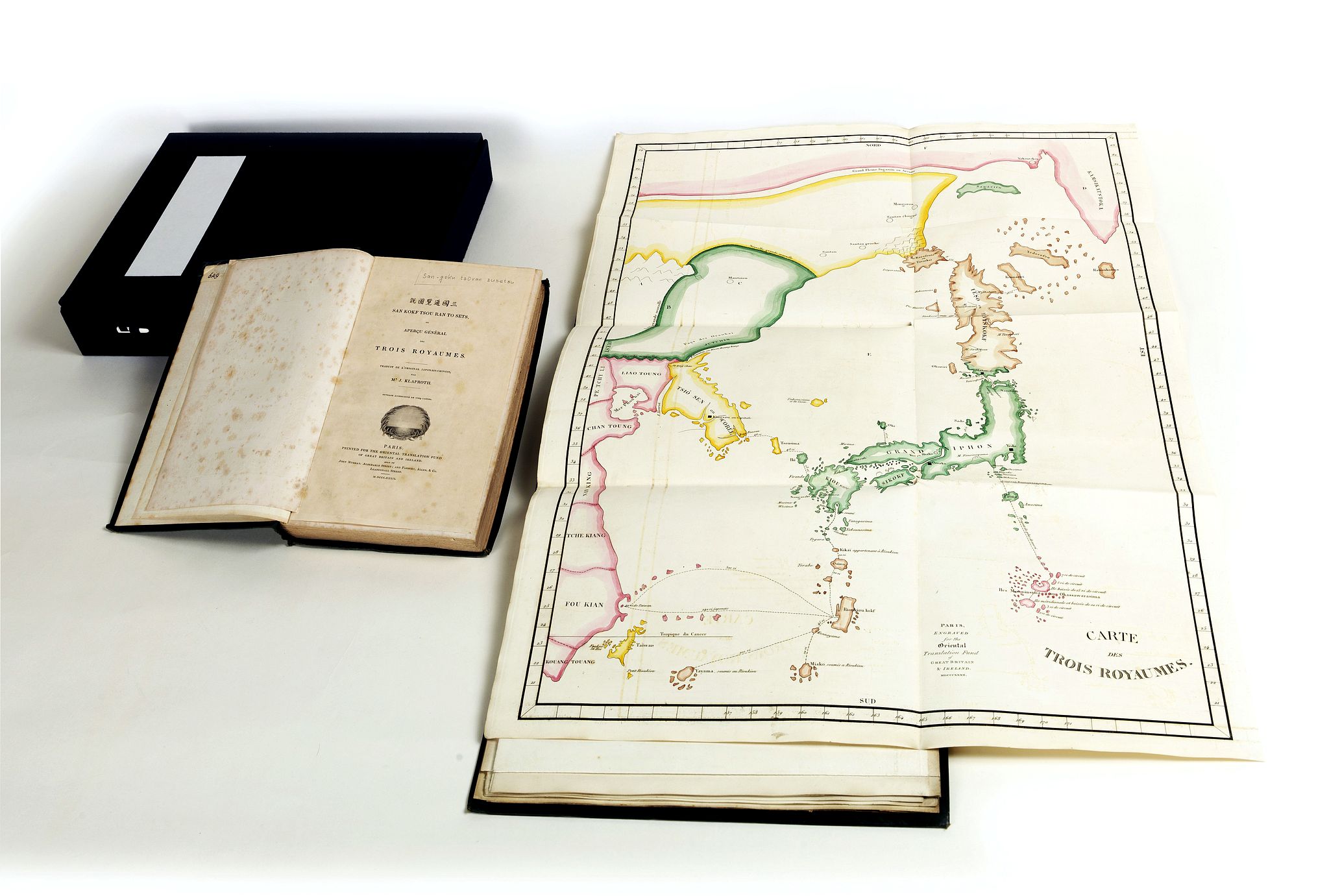
First written in Japanese and rendered in Chinese characters in 1785, this is the first Western edition of "Sangoku Tsuran Zusetsu" (Illustrated General Survey of the Three Countries) edited and translated into French by German Orientalist Julius von Klaproth (1783-1835).
Printed for the Oriental Translation Fund of Great Britain. Although certainly an able interpretation and impressive work of scholarship, this edition is most extraordinary for its large quarto album, which includes five magnificent hand-colored, engraved maps:
Map: 1. "Carte des Trois Royaumes", Including: Sagariin [Sakhalin Island], Kamsikatstoka, Isseo Ye Biskokof [Hokkaido], Grand Niphon [all Japanese Islands], Rioukiou Kokf [Loo Choo Islands], Taiwan, the coast of mainland China from the Sagariin River in the North, down to Kouang Touang & Fou Kian in the South, with Tche Kiang, Nan King, Chan Toung, Tsio Sen Coree [Korea], Liao Touong and Mantsiou [Manchuria] areas nicely shown.
In modern terms, it covers from the Sea of Okhotsk and the southern tip of Kamchatka south as far as Taiwan and the Ogasawara Islands, including the modern-day countries of Japan and Korea, as well as parts of China and Russia.
Today, it is significant because it includes the disputed Dokdo Islands (Takeshima / Liancourt Rocks) definitively defined as Korean territory.
Map 2: "Carte des Huit Provinces du Tchao Sian." [Chosen or Corea]: a magnificent pictorial map, with yellow outline, showing the whole country and each of its provinces, with the King's Residence located in KING KI [Seoul] with a large black square castle noted. The upper portion or the North, shows Liao Toung & Ju Tchin, with the rivers separating them from Korea. Each province named, with rivers, main towns, villages, mountains & rivers noted. The lower portion shows Tsousima in green, some 40 Ri [miles] from Korea. To the East is the Thsian Chan Koue island. This is a major & primitive European map of Korea.
Map 3: "Carte de L'Ile de Ieso", Is a primitive map of Hokkaido showing Kamsikatstoka or Kouroumouse to the North in red outline, Sagariin Island in green outline, Karafouto-Sima to the West with yellow & brown outline and part of Mantsiou. The main island of Iesso is with brown outline, and shows mountains, rivers, towns and sea routes in Ri [miles], with Province Ooshiou in the south and Matsumaye at the tip of Iesso in green outline, noting Japanese influence.
Map 4: "Carte des Iles Riou Kiou", is a great example of an early primitive European map. Shows the tip of Japan at the North and Kagoshima with adjacent Islands in green. The Ryukyu chain begins in brown, with Oosima & Toknosima, the main island and the citadel Ziouli in heavy black outline, all provinces, cities, mountains noted. The outer islands, South to Yama Island and its smaller islands then Taiwan in yellow. The coast of China in red shows Kyoo To Sio, Fo Ken Sio, Se Kiang Sio, Nan King Sio, San Tong Sio [provinces] to the West. The major sea routes from Japan are recorded with a dotted line in Li [miles] all through the chain and to Fo Ken.
Map 5: Carte de Iles Inhabites ou Mou Nin Sima..", shown just below Idzou province in Japan in green outline, along with the scattered islands and the ship route with Ri [miles]. Down to the Ogassawara chain outlined in red. Shows all of the islands in this area from the large Ile Septentrionale and Ile Meridionale with the smaller ones.
All of the maps are folding, the largest folds out to 21 1/4 x 28 1/2 inches, or 540 x 725 mm.
Of greatest interest is ALPHABET ET SYLLABAIRE COREEN, sheet size 31.5 x 24 cm., shows 205 Hangul characters and their sounds written in romanized letters alongside. This is the first time the Korean Hangul characters were published in the West.
Published in Edo, Japan at the end of the eighteenth-century, "San kokf tsou ran" to sets was written by Hayashi Shihei (1738-1793), a Japanese military strategist, explorer, and writer also known as Rinsifee. In this book, Rinisfee recounts an exploratory survey of the geography of the regions that were then the frontiers of Japan, including Korea, Hokkaido, and the Ryukyu Islands, and provides descriptions of the inhabitants, including the Ainu. Anticipating European infiltration of Japan, in later works Rinisfee would advocate for improved defenses along Japanese frontiers and a stronger maritime presence.
Julius Heinrich Klaproth was the son of a famous father, Martin Heinrich Klaproth, the owner of the pharmacy The White Swan in Berlin and member of the Academy of Sciences, an outstanding scientist – he discovered no less than four chemical elements, among them uranium. As a boy young Klaproth was proficient in science but later on he felt attracted by Oriental languages, to a degree that he went to the Berlin Royal Library to study the Chinese-Spanish dictionary of Father Diaz and other books pertaining to China.
Klaproth published several dozen translations during his lifetime but is probably best known for his 1823 work Asia polyglotta nebst Sprachatlas, one of the first linguistic surveys of Oriental languages.
Provenance : With a bound-in page : "This copy was printed for Sir. T.Phillipps, Bart. M.R.S.I. A subscriber to the Oriental Translation Fund".
Sir Thomas Phillipps, 1st Baronet (1792 – 1872) was an English antiquary and book collector who amassed the largest collection of manuscript material in the 19th century. He was an illegitimate son of a textile manufacturer and inherited a substantial estate, which he spent almost entirely on vellum manuscripts and, when out of funds, borrowed heavily to buy manuscripts, thereby putting his family deep into debt.
Phillipps recorded in an early catalogue that his collection was instigated by reading various accounts of the destruction of valuable manuscripts.
Such was his devotion that he acquired some 40,000 printed books and 60,000 manuscripts, arguably the largest collection a single individual has created.
Reference: Cordier 2946. Kyoto University of Foreign Studies: NIPPONALIA supplement #1616, p.170 for bibliographic details.
FAQ - Guarantee - Shipping
Buying in the BuyNow Gallery
This item is available for immediate purchase when a "Add to Cart" or "Inquire Now" button is shown.
Items are sold in the EU margin scheme
Payments are accepted in Euros or US Dollars.
Authenticity Guarantee
 We provide professional descriptions, condition report (based on 45 years experience in the map business)
Paulus Swaen warrants the authenticity of our items and a certificate of authenticity is provided for each acquired lot.
Condition and Coloring
We indicate the condition of each item and use our unnique HiBCoR grading system in which four key items determine a map's value: Historical Importance, Beauty, Condition/Coloring and Rarity.
Color Key
We offer many maps in their original black and white condition. We do not systematically color-up maps to make them more sellable to the general public or buyer.
Copper engraved or wood block maps are always hand colored. Maps were initially colored for aesthetic reasons and to improve readability. Nowadays, it is becoming a challenge to find maps in their original colors and are therefor more valuable.
We use the following color keys in our catalog:
Original colors; mean that the colors have been applied around the time the map was issued.
Original o/l colors; means the map has only the borders colored at the time of publication.
Colored; If the colors are applied recently or at the end of the 20th century.
Read more about coloring of maps [+]
Shipping fee
A flat shipping fee of $ 30 is added to each shipment by DHL within Europe and North America. This covers : International Priority shipping, Packing and Insurance (up to the invoice amount).
Shipments to Asia are $ 40 and rest of the world $50
We charge only one shipping fee when you have been successful on multiple items or when you want to combine gallery and auction purchases.
Read more about invoicing and shipping
FAQ
Please have a look for more information about buying in the BuyNow gallery
Many answers are likely to find in the general help section.
Virtual Collection
![]()
With Virtual Collection you can collect all your favorite items in one place. It is free, and anyone can create his or her Virtual map collection.
Unless you are logged in, the item is only saved for this session. You have to be registed and logged-in if you want to save this item permanently to your Virtual Collection.
Read More[+]
Register here, it is free and you do not need a credit card.
Add this item to
Virtual Collection
or click the following link to see my Virtual Collection.
| High-Resolution Digital Image Download | |
|
Paulus Swaen maintains an archive of most of our high-resolution rare maps, prints, posters and medieval manuscript scans. We make them freely available for download and study. Read more about free image download |
Click this image for a free HR-image download. |
In accordance with the EU Consumer Rights Directive and habitually reside in the European Union you have the right to cancel the contract for the purchase of a lot, without giving any reason.
The cancellation period will expire 14 calendar days from the day after the date on which you or a third party (other than the carrier and indicated by you) acquires, physical possession of the lot. To exercise the right to cancel you must inform Paulus Swaen Europe bv, which is offering to sell the lot either as an agent for the seller or as the owner of the lot, of your decision to cancel this contract by a clear statement (e.g. a letter sent by post, or e-mail (amsterdam@swaen.com).
To meet the cancellation deadline, it is sufficient for you to send your communication concerning your exercise of the right to cancel before the cancellation period has expired.