
Secunda etas mundi. Folium XIII. |
||||||||||||||||||||
|
||||||||||||||||||||
|
|
||||||||||||||||||||
$25000 / ≈ €21304This item is available for immediate sale! Questions before Buying ?
We are happy to answer your questions.
25000.00
|
Virtual Collection - Save and collect this or any of your favorite items in one place.
If you want to save the items permanently, please sign in or create account first. |
|||||||||||||||||||
Description
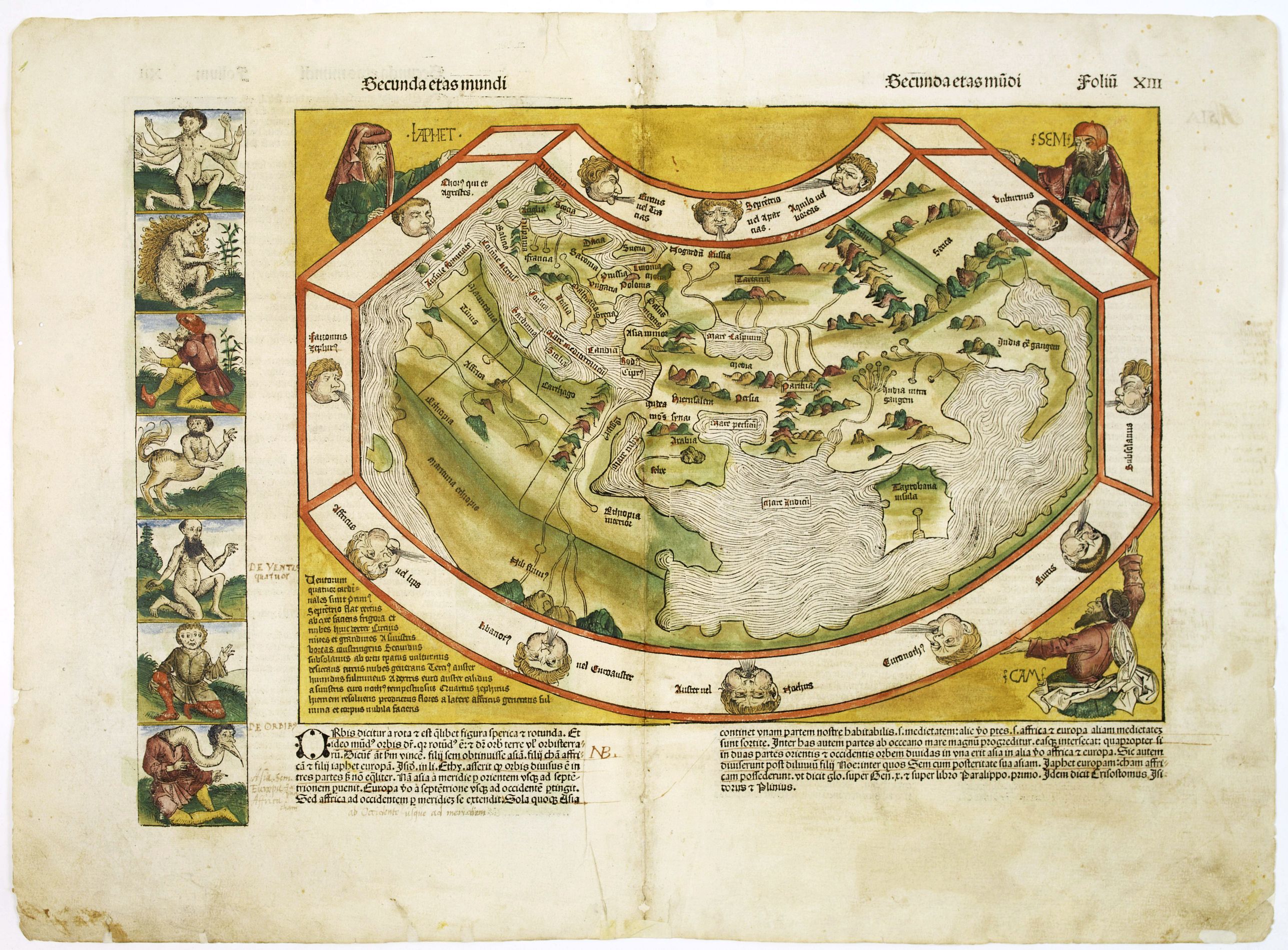
Schedel's world map was based on the cartographic system of Claudius Ptolemy, the great second-century AD geographer whose scholarship formed the foundation for map production in the fifteenth century.
Its configuration is ostensibly based on Ptolemy's second projection but simplified for a popular audience, without the scientific apparatus of latitudes, longitudes, scales and extensive nomenclature.
The map provides a window onto the late medieval imagination. The border contains twelve dour wind-heads, while the map is supported in three of its corners by the solemn figures of Ham, Shem and Japhet taken from the Old Testament.
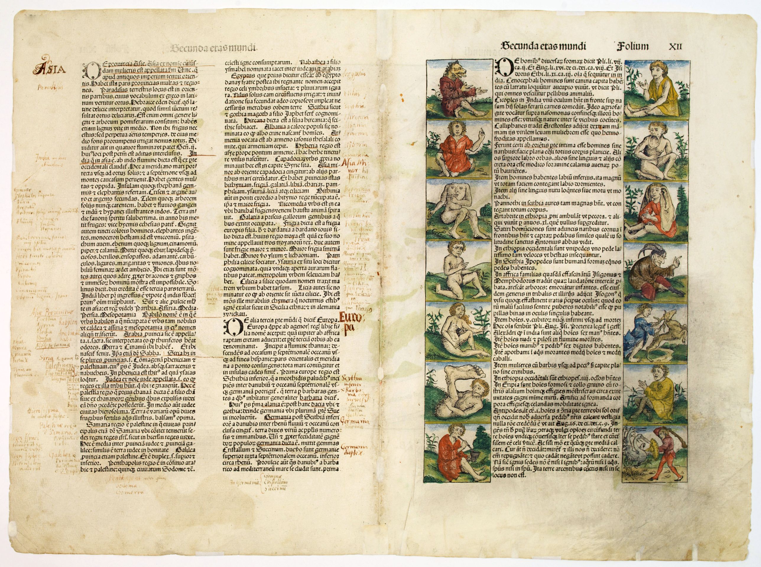
Most remarkable are the panels representing creatures that were thought to inhabit the furthermost parts of the earth. There are seven such scenes to the left of the map and a further fourteen on its verso.
Among the scenes are a six-armed man, a centaur, a four-eyed man from a coastal tribe in Ethiopia, a dog-headed man from the Simien Mountains, a cyclops, a man with a single giant foot, a man with a huge lower lip, a man with ears hanging down to his waist, and other frightening and fanciful creatures.
Page from the richest illustrated Incunable, the famous:
Liber chronicarum or Nuremberg Chronicle, was published the year that Columbus returned to Europe after discovering America.
The woodblock cutters were Michael Wolgemut, the well-known teacher of Albrecht Dürer, and his stepson Wilhelm Pleydenwurff. Wohlgemut was Albrecht Dürer's tutor between 1486-90 and recent scholarship has shown, that Albrecht Dürer may also have collaborated since some of the cuts bear a remarkably close resemblance to the Apocalypse illustrations.
The printing was carried out under the supervision of the great scholar-printer Anton Koberger, whose printing was famous throughout Europe
An opportunity to acquire a 15th-century book illustration by named artists.!
Learn more about the Nüremberg Chronicle [+]
The map provides a window onto the late medieval imagination. The border contains twelve dour wind-heads, while the map is supported in three of its corners by the solemn figures of Ham, Shem and Japhet taken from the Old Testament.
Most remarkable are the panels representing creatures that were thought to inhabit the furthermost parts of the earth. There are seven such scenes to the left of the map and a further fourteen on its verso.
Among the scenes are a six-armed man, a centaur, a four-eyed man from a coastal tribe in Ethiopia, a dog-headed man from the Simien Mountains, a cyclops, a man with a single giant foot, a man with a huge lower lip, a man with ears hanging down to his waist, and other frightening and fanciful creatures.
Page from the richest illustrated Incunable, the famous: Liber chronicarum or Nuremberg Chronicle, was published the year that Columbus returned to Europe after discovering America.
The woodblock cutters were Michael Wolgemut, the well-known teacher of Albrecht Dürer, and his stepson Wilhelm Pleydenwurff. Wohlgemut was Albrecht Dürer's tutor between 1486-90 and recent scholarship has shown, that Albrecht Dürer may also have collaborated since some of the cuts bear a remarkably close resemblance to the Apocalypse illustrations.
The printing was carried out under the supervision of the great scholar-printer Anton Koberger, whose printing was famous throughout Europe
Learn more about the Nüremberg Chronicle [+]
FAQ - Guarantee - Shipping
Buying in the BuyNow Gallery
This item is available for immediate purchase when a "Add to Cart" or "Inquire Now" button is shown.
Items are sold in the EU margin scheme
Payments are accepted in Euros or US Dollars.
Authenticity Guarantee
 We provide professional descriptions, condition report (based on 45 years experience in the map business)
Paulus Swaen warrants the authenticity of our items and a certificate of authenticity is provided for each acquired lot.
Condition and Coloring
We indicate the condition of each item and use our unnique HiBCoR grading system in which four key items determine a map's value: Historical Importance, Beauty, Condition/Coloring and Rarity.
Color Key
We offer many maps in their original black and white condition. We do not systematically color-up maps to make them more sellable to the general public or buyer.
Copper engraved or wood block maps are always hand colored. Maps were initially colored for aesthetic reasons and to improve readability. Nowadays, it is becoming a challenge to find maps in their original colors and are therefor more valuable.
We use the following color keys in our catalog:
Original colors; mean that the colors have been applied around the time the map was issued.
Original o/l colors; means the map has only the borders colored at the time of publication.
Colored; If the colors are applied recently or at the end of the 20th century.
Read more about coloring of maps [+]
Shipping fee
A flat shipping fee of $ 30 is added to each shipment by DHL within Europe and North America. This covers : International Priority shipping, Packing and Insurance (up to the invoice amount).
Shipments to Asia are $ 40 and rest of the world $50
We charge only one shipping fee when you have been successful on multiple items or when you want to combine gallery and auction purchases.
Read more about invoicing and shipping
FAQ
Please have a look for more information about buying in the BuyNow gallery
Many answers are likely to find in the general help section.
Virtual Collection
![]()
With Virtual Collection you can collect all your favorite items in one place. It is free, and anyone can create his or her Virtual map collection.
Unless you are logged in, the item is only saved for this session. You have to be registed and logged-in if you want to save this item permanently to your Virtual Collection.
Read More[+]
Register here, it is free and you do not need a credit card.
Add this item to
Virtual Collection
or click the following link to see my Virtual Collection.
| Digital Image Download | |
|
Paulus Swaen maintains an archive of most of our high-resolution rare maps, prints, posters and medieval manuscript scans. We make them freely available for download and study. Read more about free image download |
Click the image for a free small image download. |
In accordance with the EU Consumer Rights Directive and habitually reside in the European Union you have the right to cancel the contract for the purchase of a lot, without giving any reason.
The cancellation period will expire 14 calendar days from the day after the date on which you or a third party (other than the carrier and indicated by you) acquires, physical possession of the lot. To exercise the right to cancel you must inform Paulus Swaen Inc, of your decision to cancel this contract by a clear statement (e.g. a letter sent by post, or e-mail (amsterdam@swaen.com).
To meet the cancellation deadline, it is sufficient for you to send your communication concerning your exercise of the right to cancel before the cancellation period has expired.

