Islamic Cartography
 In the year 1138, the royal palace at Palermo, Sicily, was the scene of a long-awaited meeting between an unusual Christian king and a distinguished Muslim scholar. As his visitor entered the hall, the king rose, took his hand and led him across the carpeted marble to a place of honor beside the throne. Almost at once, the two men began to discuss the project for which the scholar had been asked to come from North Africa: the creation of the first accurate—and scientific—map of the entire known world.
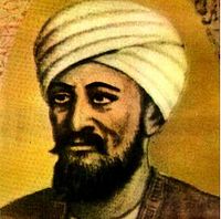
The monarch was Roger II, King of Sicily; his distinguished guest was the Arab geographer al-Idrisi. Born in Ceuta, Morocco, across the Strait of Gibraltar from Spain, al-Idrisi was in his late 30s. After studying in Cordoba, in Muslim Spain, he spent some years traveling, covering the length of the Mediterranean, from Lisbon to Damascus. As a young man with poetic pretensions, he had written student verse celebrating wine and good company, but during his journeys he had discovered his real passion: geography.
In the Arabic/Persian/Muslim world, impressive progress was made in cartography; in fact, far more than was realized for a long time, for it is only in recent years that the full significance of these contributions has been recognized.
Ptolemy's Geography was translated into Arabic in the 9th century and soon improvements were being made using data obtained from the explorations being carried out. Al-Khwarizmi wrote a major work on cartography, which gave the latitudes and longitudes for 2,402 localities as a basis for his world map. The book, which was based on Ptolemy's Geography, lists latitudes and longitudes, cities, mountains, seas, islands, geographical regions, and rivers. The manuscript does include maps that are more accurate than those of Ptolemy, in particular, it is clear that where more local knowledge was available to al-Khwarizmi such as in the regions of Islam, Africa and the Far East then his work is considerably more accurate than that of Ptolemy, but for Europe al-Khwarizmi seems, on the whole, to have used Ptolemy's data.
The major work by Sezgin, has done much to demonstrate that the medieval Islamic geographers had an important influence on the development of geography in Europe up to 1800. In he presents a reconstruction of al-Khwarizmi's map of the world which he believes used a stereographic projection of the terrestrial hemisphere, with a pole on the terrestrial equator. Sezgin also argues that Ptolemy's Geography may not have included a world map and that some later world maps are based, at least in part, on Islamic sources.
The next important Islamic scholar we should mention is al-Biruni who wrote his Cartography in around 995. In it he discussed map projections due to other scientists, then gives his own interesting mapping of a hemisphere onto a plane. A detailed description of this projection is given in [17]. Al-Biruni wrote a textbook on the general solution of spherical triangles around 1000 then, sometime after 1010, he applied these methods on spherical triangles to geographical problems. He introduced techniques to measure the Earth and distances on it using triangulation. He computed very accurate values for the differences in longitude and latitude between Ghazni in Afghanistan and Mecca. He found the radius of the earth to be 6339.6 km, a value not obtained in the West until the 16th century. His Masudic canon contains a table giving the coordinates of six hundred places, some of which were measured by al-Biruni himself, some being taken al-Khwarizmi's work referred to above.
At a time when Christian Europe was producing religious representations of the world rather than scientific maps, another type of map, or perhaps more accurately chart, for the use of sailors began to appear. These were called portolan maps (from the Italian word for a sailing manual) and were produced by sailors using a magnetic compass. The earliest examples we know about the date from the beginning of the 14th century, and were Italian or Catalan portolan maps. The earliest portolan maps covered the Mediterranean and the Black Sea and showed wind directions and such information useful to sailors. The coastlines shown on these maps are by far the most accurate to have been produced up to that time. The Catalan World Map produced in 1375 was the work of Abraham Cresques from Palma in Majorca. He was a skilled cartographer and instrument maker and the map was commissioned by Charles V of France. The western part of his map was partly based on portolan maps while the eastern part was based on Ptolemy's data.
By al-Idrisi's time, Muslim astronomers had made great strides in methods of reckoning latitude. (Longitude remained a problem until the 17th century.) Arab geographers had corrected some of the errors of Ptolemy and other Greek scientists. The mathematician al-Khwarizmi reduced Ptolemy's estimate of the length of the Mediterranean Sea from 62 to 52 degrees; the Spanish Muslim astronomer al-Zarqali further adjusted the figure to the correct 42. Other Muslim scholars, like the Iraqi astronomer al-Battani and the Persian al-Biruni, composed tables giving the latitudes of leading cities.
Al-Idrisi himself gave three figures for the earth's circumference, without deciding among them: Eratosthenes' approximately correct estimate, a slightly smaller figure arrived at by Indian astronomers, and a still smaller number—though larger than Ptolemy's—which was apparently agreed on by Sicilian scholars.
Cartography, nevertheless, remained in a primitive state. Although Ptolemy had discussed several kinds of projection, the problem of flattening out the surface of a sphere so that it could be represented on a map was not solved until the 16th and 17th centuries—the Age of Exploration—and none too satisfactorily even then.
The great geographer Gerardus Mercator commented, if you wish to sail from one port to another here is a chart and follow it carefully and you will certainly arrive at your destination. You may get there sooner or not as soon as expected, but there is al-idrisi's silver disk planisphere whose projection is considerably in advance of others of its time.
On the disk, according to al-Idrisi's own account, were incised "by skillful workers'' lines marking the limits of the seven climates of the habitable world, arbitrary divisions established by Ptolemy running east and west and bounded by parallels of latitude, from the Arctic to the Equator. Below the Equator, an unexplored southern temperate zone was thought to be separated from the familiar northern one by an impassable area of deadly heat. Following the rough sketch prepared by al-Idrisi, the silversmiths transferred the outlines of countries, oceans, rivers, gulfs, peninsulas and islands to the planisphere.
Al-Idrisi presented the planisphere, a silver celestial sphere and the book to his patron in 1154, just a few weeks before Roger died at 58, probably of a heart attack; he went on to compose another geographical work for William I, Roger's successor. This work is said to have been even more extensive than his earlier one, but only a few extracts have survived.
As he had brought the Arabic text with him, however, his great work lived on, winning widespread fame, serving as a model for Muslim geographers and historians for centuries and providing the great Muslim historian, Ibn Khaldun, with practically all his geographical knowledge.
It was not, however, available in Europe. Although the Arabic text of Roger's Book was published in Rome by the Medici press in 1592, it was not again available to Europeans in Latin until the 17th century. In the 1400's, therefore, Christopher Columbus had to rely on other sources of information. Using a globe prepared by a German cartographer named Martin Behaim—based on Ptolemy's miscalculations—Columbus also added in Marco Polo's equally misleading estimates of distances and concluded, incorrectly, that by sailing west from Spain he could reach Japan or India after no more than a 4,000-mile voyage.
It is a curious thought that had Columbus been aware of the true distance—from al-Idrisi's estimates—he might have hesitated to undertake his epoch-making voyage and might never have discovered that new world which came to light one morning on the far side of the "Sea of Darkness."
( source : http://www.saudiaramcoworld.com/issue/197704/al-idrisi.and.roger.s.book.htm )
Further interesting reading at : http://cartographic-images.net/Cartographic_Images/219_al-Idrisi.html
The next important Islamic scholar we should mention is al-Biruni who wrote his Cartography in around 995. In it he discussed map projections due to other scientists, then gives his own interesting mapping of a hemisphere onto a plane. A detailed description of this projection is given in [17]. Al-Biruni wrote a textbook on the general solution of spherical triangles around 1000 then, sometime after 1010, he applied these methods on spherical triangles to geographical problems. He introduced techniques to measure the Earth and distances on it using triangulation. He computed very accurate values for the differences in longitude and latitude between Ghazni in Afghanistan and Mecca. He found the radius of the earth to be 6339.6 km, a value not obtained in the West until the 16th century. His Masudic canon contains a table giving the coordinates of six hundred places, some of which were measured by al-Biruni himself, some being taken al-Khwarizmi's work referred to above.
At a time when Christian Europe was producing religious representations of the world rather than scientific maps, another type of map, or perhaps more accurately chart, for the use of sailors began to appear. These were called portolan maps (from the Italian word for a sailing manual) and were produced by sailors using a magnetic compass. The earliest examples we know about date from the beginning of the 14th century, and were Italian or Catalan portolan maps. The earliest portolan maps covered the Mediterranean and Black Sea and showed wind directions and such information useful to sailors. The coastlines shown on these maps are by far the most accurate to have been produced up to that time. The Catalan World Map produced in 1375 was the work of Abraham Cresques from Palma in Majorca. He was a skilled cartographer and instrument maker and the map was commissioned by Charles V of France. The western part of his map was partly based on portolan maps while the eastern part was based on Ptolemy's data.
By al-Idrisi's time, Muslim astronomers had made great strides in methods of reckoning latitude. (Longitude remained a problem until the 17th century.) Arab geographers had corrected some of the errors of Ptolemy and other Greek scientists. The mathematician al-Khwarizmi reduced Ptolemy's estimate of the length of the Mediterranean Sea from 62 to 52 degrees; the Spanish Muslim astronomer al-Zarqali further adjusted the figure to the correct 42. Other Muslim scholars, like the Iraqi astronomer al-Battani and the Persian al-Biruni, composing tables giving the latitudes of leading cities.
Al-Idrisi himself gave three figures for the earth's circumference, without deciding among them: Eratosthenes' approximately correct estimate, a slightly smaller figure arrived at by Indian astronomers, and a still smaller number—though larger than Ptolemy's—which was apparently agreed on by Sicilian scholars.
Cartography, nevertheless, remained in a primitive state. Although Ptolemy had discussed several kinds of projection, the problem of flattening out the surface of a sphere so that it could be represented on a map was not solved until the 16th and 17th centuries—the Age of Exploration—and none too satisfactorily even then. The great geographer Gerardus Mercator commented: if you wish to sail from one port to another, here is a chart and follow it carefully will certainly arrive at your of destination may get there sooner or not as soon expected, but there." al-idrisi's silver disk, "planisphere," was form projection considerably in advance others its time.
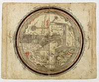 After ISAL-ISTAKHRI. The world, centered on the Persian Gulf. Ottoman province, c. 1820. 260 x 290mm. World map in manuscript. Drawn on paper with watercolor, ink, gouache and gold highlighting.
World map in a manuscript with Arabic inscriptions, centered on the Jezirah.
This map is based on al-Istakhri's world map (977/1570 A.D.). Oriented with South at the top, just as in the T-O maps of contemporary Latin Europe, but instead of the Earthly Paradise, the Arab scholars knew enough to place China and Tibet in the furthest East.
After ISAL-ISTAKHRI. The world, centered on the Persian Gulf. Ottoman province, c. 1820. 260 x 290mm. World map in manuscript. Drawn on paper with watercolor, ink, gouache and gold highlighting.
World map in a manuscript with Arabic inscriptions, centered on the Jezirah.
This map is based on al-Istakhri's world map (977/1570 A.D.). Oriented with South at the top, just as in the T-O maps of contemporary Latin Europe, but instead of the Earthly Paradise, the Arab scholars knew enough to place China and Tibet in the furthest East.
The map shows Egypt and the river Nile in the right and further on "Country of the Black People". Note how the tip of Africa points eastwards, a mistake that the Chinese geographers were the first to correct.
In the lower right corner of Europe, i.e., "Country of the Romans and Franks... " The map shows the Indus in the lower left, with the Indian Peninsula, Tibet, and the Chinese Empire, and the Red Sea colored in red. The outer circles represent the seas.
The manuscript is a cosmology, not meant to be geographically accurate, but only to present the reader with a systematic overview of the existing knowledge of the world at the time.
This map has been sold
According to Arab geographical theory based entirely on Ptolemy, this would be a sphere. Since the far side of a world sphere (an upside-down world) was practically inconceivable, only a hemisphere was thought to be habitable. This could easily be “projected” onto a flat area and represented by a circle.
That Ptolemy represented the habitable world as occupying 180 degrees of the earth supported this idea. Thus al- Istakhri represented the world as a circle surrounded by the Encompassing Sea, with the two main seas reaching in from the east and the west toward the center, where they would join except for a small, narrow land barrier—the barzakh of the Qur’an.
In his text, al-Istakhri gives a simple description of the world to explain his map. “The earth is divided into two by the two seas, so that we have a north or cold half and a south or hot half. People in these two halves get blacker as you go south and whiter as you go north etc.”
The main kingdoms are listed together with the kingdoms that adjoin them. This is the only place where non-Islamic areas are given any mention. Measurements are attempted; thus the width from the Encircling Ocean in northwestern Africa to the ocean in China was 400 days’ journey. However, the distance north to south was not measurable. There were 210 days’ journey through uninhabitable lands, but the extreme north was uninhabited because of intense cold, and the extreme south because of intense heat. The seas were described briefly, and the fact that the Khazar [Caspian] Sea and the Khwarazm [Aral] Sea were landlocked is mentioned, as well as the sea connection between the Encircling Ocean and Istanbul—that is, the Baltic joins up to the Bosporus.
 Kâtip Çelebi
Kâtip Çelebi, Mustafa bin Abdullah, Haji Khalifa or Kalfa (1609-1657), was an Ottoman scholar, historian and geographer, who is regarded as one of the most productive authors of non-religious scientific literature in the 17th-century Ottoman Empire.
Kâtip became an army clerk and took part in many campaigns in the east, meanwhile collecting material for his historical works. As a child, he was taught the Qur'an and Arabic grammar and calligraphy, but his later education was irregular; he attended lectures between military campaigns. An inheritance allowed him to settle permanently in Constantinople, where, except for his duties as a government clerk, he was able to devote all his time to collecting books, studying, and writing.
He was an avid bibliophile, an industrious scholar, and a prolific and straightforward writer. Celebi began work on an atlas of maps, which was not completed and published until 1732, by Muteferrica, due to the continuing ban on printing in the Ottoman Empire.
The Cihannüma of Katip Celebi, printed in Istanbul by Ibrahim Müteferrika, was published in 1732. Müteferrika's press was the first Islamic printing house. The introduction of printing in movable type was slow to develop in the Middle East. The very earliest examples of printing in Arabic script date from the early 16th century Europe, where religious texts were printed, especially by Italian printers. Some early Arabic religious texts were also printed in presses in Christian communities in the Middle East, but it was not until the early 18th century that Islamic printing houses in the Islamic world officially authorized printing in Arabic script.
The initiative came from Said Efendi, son of the Ottoman Ambassador to Paris, who accompanied his father on a diplomatic visit there in 1721. There he had learned about printing and on his return to Istanbul, he requested the support of the Grand Vizier in the setting up of a printing press. His chief collaborator was Ibrahim Müteferrika, a man with many interests including astronomy, history, philosophy and theology. He was born in Hungary in 1674, probably a Christian who converted to Islam. The name ‘Müteferrika’ is derived from his employment as a bureaucrat and diplomat under Sultan Ahmed III.
Together with Said Efendi he was granted permission to print books in Ottoman Turkish in Arabic script. The presses and type fonts were obtained from local Jewish and Christian printers and later imported from Europe. Ibrahim Müteferrika became the director of the first Turkish printing press. The first book, a dictionary, was printed in 1729. Religious texts were officially excluded because they were still copied only in manuscript form. There was a vested interest among the local scribes and calligraphers to prevent the growth of printing. The cursive design of the Arabic script lent itself particularly well to manuscript production and the manuscript workshops presented a constant opposition to Müteferrika’s enterprise.
Important among his printed works was the world atlas, the ‘Cihannüma’ of Katip Celebi printed in 1732. This is a world atlas, or cosmography, loosely translated as ‘The mirror of the world’. Celebi (1609–1657) was an Ottoman historian, bibliographer and geographer and the most conspicuous and productive scholar, particularly in the non-religious sciences in the 17th-century Ottoman Empire. He was a life-long friend of Müteferrika.
Müteferrika has himself added a significant introduction to his printing of Celebi’s work in which he discusses the Copernican view of astronomy. He is considered one of the first to introduce the Copernican view of the solar system to Ottoman readers.
The diagrams and maps within the volume, of which there are over forty, cover the countries of the Middle East, the Mediterranean and areas farther afield.
Back in Istanbul, however, the printing activities did not last and came to an end in 1743, due to strong opposition of the local scribes to Müteferrika’s enterprise. He died in 1745, after printing works on grammar, geography, maths and above all, history; books from his press are often known as the ‘Turkish incunabula’. But this change was not long-lasting and printing houses eventually grew up in other Middle Eastern cities. Eventually, even the ban of printing religious texts was lifted and the first printed Qur’an texts appeared in the 1860s.
 MAHMUT RAIF EFENDI well known for his Cedid Atlas Tercümesi or New Translation of the Atlas, the first Muslim-published world atlas based on European geographic knowledge and cartographic methods. Printed 1218 H. or 1803 in Üsküdar, a part of Istanbul. Title, scale and place names in Ottoman Turkish.
The atlas is an Ottoman translation of William Faden's atlas. The atlas was produced to provide modern geographic information for students and teachers at the military engineering school, and for officials in the Ottoman War and Foreign Ministries.
Composed of 24 maps, it is the first Muslim-published world atlas based on European geographic knowledge and cartographic methods. Except for the celestial chart, all the maps in the atlas are based on cartographic works from editions of William Faden's General Atlas. A number of editions of the General Atlas were issued in the late 18th and early 19th centuries, but the specific edition used as the basis for the Cedid Atlas is unknown.
The recent publication of Kemal Beydilli's Turk Bilim ve Matbaacilik Tarihinde Muhendishâne ve Kutuphanesi (1776-1826) (Istanbul: Eren, 1995) provides valuable background information about the creation and compilation of the atlas.
The copy of Faden's General Atlas used to compile the Cedid Atlas was acquired by Mahmud Ra'if Efendi when he was private secretary to the Ottoman ambassador in London.
 Only 50 copies of the atlas were produced. One special copy was printed for Selim III, six others were given to important state officials, and two were placed in the library of the Engineering School. The rest were made available to the public.
It is estimated that no more than 20 complete atlases and about 5 incomplete or loose sheets are in existence.
A comparison of the contents of the Cedid Atlas with those of the General Atlas provides insight into which geographic regions the Ottomans considered most important.
The atlas contains separate maps of each continent and the majority of the maps naturally focus on the lands adjacent to the Mediterranean Sea and maritime Europe. There is only one plate each for Africa (aside from the Mediterranean) and Asia, but four plates cover portions of the Western Hemisphere, including a map of North America primarily east of the Mississippi River, which shows the territorial claims of Great Britain in the United States.
Mahmud Ra'if Efendi's 80-page original geographic study, Icaletu'l-Cografiye, is appended to the atlas. The atlas and geographic treatise are artifacts of the Nizam-i Cedid (New Order), the Ottomans' first effort to implement reforms based on European models.
The author was attached to the Ottoman Embassy in London. The book was written in French by Mahmut Raif Efendi and translated into Ottoman Turkish by Yakovaki Effendi.
Instituted by Sultan Selim III (1789-1807), the "New Order" attempted to incorporate European military, technical, economic and administrative achievements into the Ottoman system. The atlas was produced to provide modern geographic information for the students and teachers at the new military engineering school and for officials in the Ottoman War and Foreign ministries.
