Subscribe to be notified if similar examples become available.
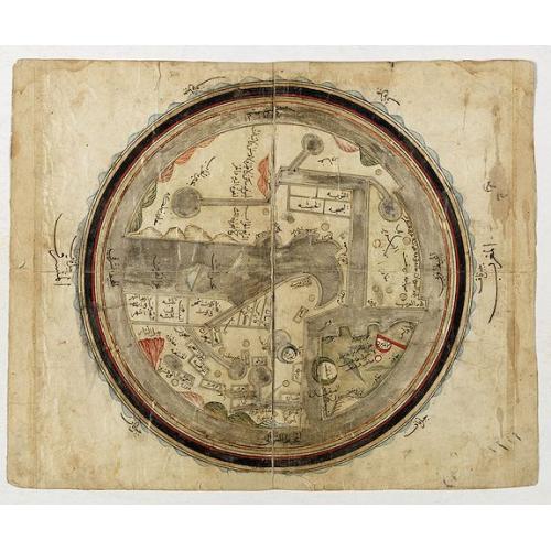
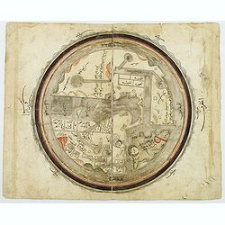
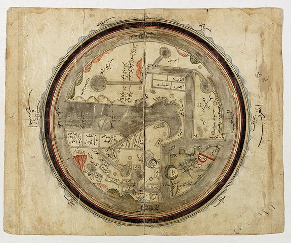
The world, centering on the Persian Gulf. |
||||||||||||||||||||
|
||||||||||||||||||||
|
|
||||||||||||||||||||
|
|
Virtual Collection - Save and collect this or any of your favorite items in one place.
If you want to save the items permanently, please sign in or create account first. |
|||||||||||||||||||
Description
World map in manuscript. Drawn on paper with watercolor, ink, gouache and gold highlighting. World map in manuscript with inscriptions in Arabic showing a map of the world centered on the Jezirah.
This is a map in the traditional Islamic style. It is based on a map that accompanied a commentary Kitab al-masalik wa-al-mamalik (Book of Realms and Kingdoms) by Al-Istakhri, produced in the middle of the tenth century, approximately 930-933 (318-321).
A second version of the commentary was produced in 951 (340). The world map that accompanied the commentaries was a stylized representation of the world, more cosmological than geographical. It depicted a spherical world surrounded by seas. South is at the top. It is centered in Arabia with the tip of Africa pointing East. It was more of a diagram than a map, summarizing the world as then known to Arab and Persian geographers. Twelfth-century copies of this original map are held in Berlin and Bologna.
The map then became the template for subsequent world maps including a World Map by Ibn Hawqal, produced in 988 (378) and further refined by Ibn al-Wardi in a world map produced around 1593 (1001) and now held in the British Library.
So the current map is derived from Al-Istakhri through Ibn Hawqal and Ibn al-Wardi. It was probably held in Istanbul as most of the variants of Ibn Hawqal were kept in the Topkapi Museum in Istanbul.
It was made later than 1600 because it has more text than the 1593 Al Wardi map, suggesting a later overlay of some description. There is a variety of Arabic script styles also suggestive of overlain writings at different times. The style is less geometric than the Al-Wardi maps indicating a greater Ottoman influence.
Research and text by John Rennie Short (Professor of Public Policy at the University of Maryland (UMBC).)
al-Istakhri's world map is oriented with the South at the top, just as in the T-O maps of contemporary Latin Europe, but instead of the Earthly Paradise, the Arab scholars knew enough to place in the furthest East both China and Tibet.
The map shows Egypt and the river Nile in the right and further on "Country of the Black People". Note how the tip of Africa points eastwards, a mistake which the Chinese geographers were the first to correct.
In the lower right corner Europe, i.e. "Country of the Romans and Franks".. " The map shows the Indus in the lower left, with the Indian Peninsula, Tibet and Chinese Empire and The Red Sea colored in red. The outer circles represent the seas.
The manuscript is a cosmology, not meant to be accurate geographically, but only to present the reader with a systematic overview of the existing knowledge about the world at the time.
According to Arab geographical theory based entirely on Ptolemy, this would be a sphere. Since the far side of a world sphere (an upside-down world) was practically inconceivable, only a hemisphere was thought to be inhabitable. This could easily be “projected” onto a flat area and represented by a circle.
That Ptolemy represented the inhabitable world as occupying 180 degrees of the earth supported this idea. Thus al- Istakhri represented the world as a circle surrounded by the Encompassing Sea, with the two main seas reaching in from the east and the west toward the center, where they would join except for a small, narrow land barrier—the barzakh of the Qur’an .
In his text, al-Istakhri gives a simple description of the world to explain his map. “The earth is divided into two by the two seas so that we have a north or cold half and south or hot half. People in these two halves get blacker as you go south and whiter as you go north etc.” The main kingdoms are listed together with the kingdoms that adjoin them. This is the only place where non-Islamic areas are given any mention. Measurements are attempted; thus the width from the Encircling Ocean in northwestern Africa to the ocean in China was 400 days’ journey. However, the distance from north to south was not measurable. There was 210 days’ journey through inhabitable lands, but the extreme north was uninhabited because of intense cold and the extreme south because of intense heat. The seas were described briefly, and the fact that the Khazar [Caspian] Sea and the Khwarazm [Aral] Sea were landlocked is mentioned, as well as the sea connection between the Encircling Ocean and Istanbul—that is, the Baltic joins up to the Bosporus.
Read more about the history of Islamic cartography. [+]

This is a map in the traditional Islamic style. It is based on a map that accompanied a commentary Kitab al-masalik wa-al-mamalik (Book of Realms and Kingdoms) by Al-Istakhri, produced in the middle of the tenth century, approximately 930-933 (318-321).
A second version of the commentary was produced in 951 (340). The world map that accompanied the commentaries was a stylized representation of the world, more cosmological than geographical. It depicted a spherical world surrounded by seas. South is at the top. It is centered in Arabia with the tip of Africa pointing East. It was more of a diagram than a map, summarizing the world as then known to Arab and Persian geographers. Twelfth-century copies of this original map are held in Berlin and Bologna. The map then became the template for subsequent world maps including a World Map by Ibn Hawqal, produced in 988 (378) and further refined by Ibn al-Wardi in a world map produced around 1593 (1001) and now held in the British Library.
So the current map is derived from Al-Istakhri through Ibn Hawqal and Ibn al-Wardi. It was probably held in Istanbul as most of the variants of Ibn Hawqal were kept in the Topkapi Museum in Istanbul.
It was made later than 1600 because it has more text than the 1593 Al Wardi map, suggesting a later overlay of some description. There is a variety of Arabic script styles also suggestive of overlain writings at different times. The style is less geometric than the Al-Wardi maps indicating a greater Ottoman influence. Research and text by John Rennie Short (Professor of Public Policy at the University of Maryland (UMBC).)
al-Istakhri's world map is oriented with the South at the top, just as in the T-O maps of contemporary Latin Europe, but instead of the Earthly Paradise, the Arab scholars knew enough to place in the furthest East both China and Tibet.
The map shows Egypt and the river Nile in the right and further on "Country of the Black People". Note how the tip of Africa points eastwards, a mistake which the Chinese geographers were the first to correct.
In the lower right corner Europe, i.e. "Country of the Romans and Franks".. " The map shows the Indus in the lower left, with the Indian Peninsula, Tibet and Chinese Empire and The Red Sea colored in red. The outer circles represent the seas.
The manuscript is a cosmology, not meant to be accurate geographically, but only to present the reader with a systematic overview of the existing knowledge about the world at the time. According to Arab geographical theory based entirely on Ptolemy, this would be a sphere. Since the far side of a world sphere (an upside-down world) was practically inconceivable, only a hemisphere was thought to be inhabitable. This could easily be “projected” onto a flat area and represented by a circle. That Ptolemy represented the inhabitable world as occupying 180 degrees of the earth supported this idea. Thus al- Istakhri represented the world as a circle surrounded by the Encompassing Sea, with the two main seas reaching in from the east and the west toward the center, where they would join except for a small, narrow land barrier—the barzakh of the Qur’an . In his text, al-Istakhri gives a simple description of the world to explain his map. “The earth is divided into two by the two seas so that we have a north or cold half and south or hot half. People in these two halves get blacker as you go south and whiter as you go north etc.” The main kingdoms are listed together with the kingdoms that adjoin them. This is the only place where non-Islamic areas are given any mention. Measurements are attempted; thus the width from the Encircling Ocean in northwestern Africa to the ocean in China was 400 days’ journey. However, the distance from north to south was not measurable. There was 210 days’ journey through inhabitable lands, but the extreme north was uninhabited because of intense cold and the extreme south because of intense heat. The seas were described briefly, and the fact that the Khazar [Caspian] Sea and the Khwarazm [Aral] Sea were landlocked is mentioned, as well as the sea connection between the Encircling Ocean and Istanbul—that is, the Baltic joins up to the Bosporus.
FAQ - Guarantee - Shipping
Buying in the BuyNow Gallery
This item is available for immediate purchase when a "Add to Cart" or "Inquire Now" button is shown.
Items are sold in the EU margin scheme
Payments are accepted in Euros or US Dollars.
Authenticity Guarantee
 We provide professional descriptions, condition report (based on 45 years experience in the map business)
Paulus Swaen warrants the authenticity of our items and a certificate of authenticity is provided for each acquired lot.
Condition and Coloring
We indicate the condition of each item and use our unnique HiBCoR grading system in which four key items determine a map's value: Historical Importance, Beauty, Condition/Coloring and Rarity.
Color Key
We offer many maps in their original black and white condition. We do not systematically color-up maps to make them more sellable to the general public or buyer.
Copper engraved or wood block maps are always hand colored. Maps were initially colored for aesthetic reasons and to improve readability. Nowadays, it is becoming a challenge to find maps in their original colors and are therefor more valuable.
We use the following color keys in our catalog:
Original colors; mean that the colors have been applied around the time the map was issued.
Original o/l colors; means the map has only the borders colored at the time of publication.
Colored; If the colors are applied recently or at the end of the 20th century.
Read more about coloring of maps [+]
Shipping fee
A flat shipping fee of $ 30 is added to each shipment by DHL within Europe and North America. This covers : International Priority shipping, Packing and Insurance (up to the invoice amount).
Shipments to Asia are $ 40 and rest of the world $50
We charge only one shipping fee when you have been successful on multiple items or when you want to combine gallery and auction purchases.
Read more about invoicing and shipping
FAQ
Please have a look for more information about buying in the BuyNow gallery
Many answers are likely to find in the general help section.
Virtual Collection
![]()
With Virtual Collection you can collect all your favorite items in one place. It is free, and anyone can create his or her Virtual map collection.
Unless you are logged in, the item is only saved for this session. You have to be registed and logged-in if you want to save this item permanently to your Virtual Collection.
Read More[+]
Register here, it is free and you do not need a credit card.
Add this item to
Virtual Collection
or click the following link to see my Virtual Collection.
| Digital Image Download | |
|
Paulus Swaen maintains an archive of most of our high-resolution rare maps, prints, posters and medieval manuscript scans. We make them freely available for download and study. Read more about free image download |
Click the image for a free small image download. |
In accordance with the EU Consumer Rights Directive and habitually reside in the European Union you have the right to cancel the contract for the purchase of a lot, without giving any reason.
The cancellation period will expire 14 calendar days from the day after the date on which you or a third party (other than the carrier and indicated by you) acquires, physical possession of the lot. To exercise the right to cancel you must inform Paulus Swaen Inc, of your decision to cancel this contract by a clear statement (e.g. a letter sent by post, or e-mail (amsterdam@swaen.com).
To meet the cancellation deadline, it is sufficient for you to send your communication concerning your exercise of the right to cancel before the cancellation period has expired.
